CN100533503C - An interactive traffic navigation and vehicular security system - Google Patents
An interactive traffic navigation and vehicular security system Download PDFInfo
- Publication number
- CN100533503C CN100533503C CNB2006101570277A CN200610157027A CN100533503C CN 100533503 C CN100533503 C CN 100533503C CN B2006101570277 A CNB2006101570277 A CN B2006101570277A CN 200610157027 A CN200610157027 A CN 200610157027A CN 100533503 C CN100533503 C CN 100533503C
- Authority
- CN
- China
- Prior art keywords
- control center
- remote control
- data
- user terminal
- information
- Prior art date
- Legal status (The legal status is an assumption and is not a legal conclusion. Google has not performed a legal analysis and makes no representation as to the accuracy of the status listed.)
- Expired - Fee Related
Links
- 230000002452 interceptive effect Effects 0.000 title claims abstract description 19
- 238000010295 mobile communication Methods 0.000 claims abstract description 24
- 230000004224 protection Effects 0.000 claims description 23
- 238000005516 engineering process Methods 0.000 claims description 22
- 238000000034 method Methods 0.000 claims description 20
- 238000004891 communication Methods 0.000 claims description 9
- 238000001514 detection method Methods 0.000 claims description 7
- 238000012545 processing Methods 0.000 claims description 7
- 230000000007 visual effect Effects 0.000 claims description 7
- 230000008569 process Effects 0.000 claims description 6
- 230000015572 biosynthetic process Effects 0.000 claims description 3
- 230000010354 integration Effects 0.000 abstract description 4
- 238000004458 analytical method Methods 0.000 abstract description 2
- 230000009977 dual effect Effects 0.000 abstract 1
- 238000010606 normalization Methods 0.000 abstract 1
- 230000006870 function Effects 0.000 description 21
- 230000005540 biological transmission Effects 0.000 description 7
- 230000003068 static effect Effects 0.000 description 6
- 238000011161 development Methods 0.000 description 5
- 230000003993 interaction Effects 0.000 description 5
- 230000008901 benefit Effects 0.000 description 3
- 238000010586 diagram Methods 0.000 description 3
- 241001269238 Data Species 0.000 description 2
- 230000010267 cellular communication Effects 0.000 description 2
- 230000005465 channeling Effects 0.000 description 2
- 238000013461 design Methods 0.000 description 2
- 239000000284 extract Substances 0.000 description 2
- 230000002093 peripheral effect Effects 0.000 description 2
- 238000001228 spectrum Methods 0.000 description 2
- 230000001360 synchronised effect Effects 0.000 description 2
- 206010039203 Road traffic accident Diseases 0.000 description 1
- 238000009825 accumulation Methods 0.000 description 1
- 230000009286 beneficial effect Effects 0.000 description 1
- 230000007423 decrease Effects 0.000 description 1
- 230000002950 deficient Effects 0.000 description 1
- 230000000694 effects Effects 0.000 description 1
- 238000007726 management method Methods 0.000 description 1
- 230000006855 networking Effects 0.000 description 1
- 230000001314 paroxysmal effect Effects 0.000 description 1
- 230000008439 repair process Effects 0.000 description 1
- 238000004088 simulation Methods 0.000 description 1
- 238000012360 testing method Methods 0.000 description 1
- 239000002699 waste material Substances 0.000 description 1
Images


Abstract
This invention relates to an interactive traffic navigation and vehicle-carrying security system, including the remote control center and the user terminal. The remote control center includes the geographic information system for the integration and analysis of information and generating relevant data, the intelligent information system for automatic normalization and storage of the data results from the said geographic information system and providing data support for the call center, and the call center for providing interactive interface and communicating information with the vehicle-carrying terminals. The user terminal includes the vehicle-carrying terminal and the navigation instrument, the vehicle-carrying terminal including CPU, a GPS module, mobile communication module and data interface module, the navigation instrument including the dual CPU architecture, a GPS module, memory, data interface module and input/output equipment, and the vehicle-carrying terminal and the navigation instrument connects integrally through the data interface module; the vehicle-carrying terminal exchanges information with the remote control center through the mobile communication network. The invention not only protects the end-user life and property security, but also saves personal and social resources.
Description
Technical field
The present invention relates to a kind of automobile security protection and navigational system, more particularly, relate to a kind of GPS of utilization location and navigation, GIS, mobile communication technology, the interactively traffic navigation of short distance interconnection technique and vehicular security system.
Background technology
Along with The development in society and economy, people's life scope is more and more broader, and auto industry market is also ripe gradually, and this must allow the usage quantity of vehicle constantly increase, and people's the scope of driving is constantly expanded.Yet the traffic jam issue that urban transport problems, especially big city are increasingly serious usually causes the huge waste on public's time and the social resources.Both conflict mutually and contradiction allows the navigating instrument with road guiding function obtain huge market development prospect.Yet, existing navigation product is to adopt the static type navigation mode carry basically, and perhaps combining with TMC etc. provides the passive type dynamic navigation, can't carry out alternately with control center, real-time traffic situation and terminal user's demand are combined, realize interactively dynamic navigation.Therefore, be necessary to make up a kind of security protection+dynamic vehicle navigation system of supporting remote interaction.And the development of following technology, for security protection and dynamic vehicle navigation system provide support.
GPS (Global Positioning System, be called for short GPS) be that the U.S. developed since the seventies in 20th century, built up in 1994 comprehensively, have the new generation satellite navigation and the positioning system of the navigation of comprehensive real-time three-dimensional and station-keeping ability in sea, land and sky.Gps system not only can be used for location, navigation, when also can be used for measuring, test the speed and surveying.Accurately locate by the satellite-signal that GPS receives, can learn the information such as travel route, position, speed, height of vehicle.
Geographic Information System (Geographical Information System is called for short GIS) occurred since the end of the fifties, the beginning of the sixties, was to describe and the software systems of handling relevant geography information.GIS is means with the computing machine, and spatial data and information with geographic entity are handled, and has as functions such as collection, management, analysis and expression datas.GIS can handle and answer location (Location), condition (Condition), trend (Trends), pattern (Patterns), simulation problems such as (Modeling).
Global system for mobile communications (Global System for Mobile Communications is called for short GSM) based on cellular communication system, begins development in early 1980s in Europe.GSM has continued the advantage of cellular communication system channeling and intelligent network, has improved frequency efficiency, has increased the capacity of system, has also realized hand off and roaming function, whole world widespread use now.GPRS (General Packet Radio Service, be called for short GPRS), be a kind of new packet data bearers business that development is come out on existing gsm system, it adopts the frequency range identical with GSM, frequency span, burst structure, wireless-modulated standard, frequency hopping rule and identical tdma frame structure.That GPRS is specially adapted to be interrupted, paroxysmal or frequent, a spot of data transmission also are applicable to big data quantity transmission once in a while; Logical (the Code Division Multiple Access of CDMA transmission, be called for short CDMA), by several technology be combined intos such as spread spectrum, multiple access access, beehive net and channelings, contain a kind of cooperation technology that frequency domain, time domain and sign indicating number territory three dimensional signal are handled, it is good to have anti-interference, the anti-multipath decline, the secret and safe height, same frequency can be reused in a plurality of sub-districts, attributes such as trade-off can be done between capacity and the quality, the present mobile communication net can be satisfied professional demand such as high capacity, high-quality, integrated service, soft handover, international roaming.
The short distance interconnection technique comprises wireless connect technologies such as wired connection technology such as RS 232 serial ports and infrared, Bluetooth, and wherein Bluetooth is the current application focus.Bluetooth is the designate of the short-range wireless connect technology standard of a kind of low-power, it supports technology such as open 2.4GHz ISM (i.e. industry, science, the medical science) frequency range in the whole world, frequency hopping, spread spectrum, it has advantages such as support voice transmission, low-power consumption, networking be simple and convenient, and can clear the jumps in effective range connects, and does not have special communication visual angle and direction requirement.
Summary of the invention
The technical problem to be solved in the present invention is, at the passive homing of the above-mentioned static state of prior art, the strong and not high defective of real-time of interactivity provides a kind of dynamic, interactively traffic navigation and vehicular security system and method.
The technical solution adopted for the present invention to solve the technical problems is: construct a kind of interactively traffic navigation and vehicular security system, comprise remote control center and user terminal, described remote control center comprises and is used to integrate with analytical information and generates the Geographic Information System of related data, be used for the intelligent information system that automatic standard and storage provide data to support from the result data of described Geographic Information System and for the call center, and the call center that is used to provide interactive interface, carries out information communication with user terminal; Described user terminal comprises car-mounted terminal and navigating instrument, described car-mounted terminal comprises CPU, a GPS module, mobile communication module and first data interface module, and described CPU communicates with a GPS module, mobile communication module, first data interface module respectively by the serial ports expansion technology; A described GPS module is used to handle and receives the signal that obtains and send it to CPU; Described mobile communication module is used for communicating with remote control center; Described first data interface module is used for communicating with the navigating instrument that has the corresponding data interface; Described navigating instrument comprises based on dual-CPU architecture, the 2nd GPS module, storer, second data interface module and input-output device, and described car-mounted terminal is realized integrated the connection with navigating instrument by data interface module; Described car-mounted terminal is by mobile communications network and described remote control center interactive information.
In interactively traffic navigation of the present invention and vehicular security system, described data-interface comprises wireless data interface and cable data interface; Described wireless data interface comprises blue-teeth data interface and infrared data interface; Described cable data interface comprises RS 232 serial data interfaces.
In interactively traffic navigation of the present invention and vehicular security system, described car-mounted terminal also comprises handle, and described navigating instrument also comprises input and output control.
In interactively traffic navigation of the present invention and vehicular security system, the described CPU in the described car-mounted terminal communicates by serial ports expansion technology and described handle; Described handle in the described car-mounted terminal is used for operation control car-mounted terminal.
In interactively traffic navigation of the present invention and vehicular security system, described car-mounted terminal also comprises the complex programmable logic controller, is used to expand a plurality of IO interface to realize the security protection control of automobile.
In interactively traffic navigation of the present invention and vehicular security system, the road detection of described security protection controlling packet oil scraper, alarm detection, lamp detect and the lock Throttle Opening Control.
In interactively traffic navigation of the present invention and vehicular security system, the described based on dual-CPU architecture in the described navigating instrument is used to carry out signal Processing, and communicates by described second data-interface and car-mounted terminal; Described the 2nd GPS module in the described navigating instrument is used to handle the GPS locating information that reception obtains, and sends it to CPU; Described storer in the described navigating instrument comprises flash memory and/or micro harddisk, is used for the operating system of burning navigating instrument operation; Described input-output device in the described navigating instrument comprises touch-screen, safe digital memory card and USB (universal serial bus).
In interactively traffic navigation of the present invention and vehicular security system, described mobile communications network comprises GSM, GPRS and CDMA.
In interactively traffic navigation of the present invention and vehicular security system, it is characterized in that the data flow in the system comprises: the free interactive information of navigating instrument and car-mounted terminal; Remote control center is integrated and real-time update raw information; User terminal is uploaded user profile to remote control center; Remote control center receives and real-time process user information, and the raw information in conjunction with remote control center is integrated into service recommendations; Remote control center offers user terminal with service recommendations with the form of visual information and/or voice messaging.
The present invention also provides a kind of interactively traffic navigation and vehicle-mounted safety protection method, car-mounted terminal and integrated user terminal and the remote control center interactive information that is connected the back formation of navigating instrument, and described interactive information comprises the steps:
1) user terminal sends " services request " to remote control center;
2) remote control center accepts request, and replys " acceptance service ", and the service of setting up between user terminal and the remote control center connects;
3) user terminal with its data upload of extracting from gps satellite to remote control center;
4) remote control center is sent to user terminal with the dynamic data of its acquisition, upgrades the data of user terminal;
5) user terminal proposes the individual character requirement to remote control center, and the dynamic data that remote control center sends is provided feedback and estimates suggestion;
6) remote control center receives and process user demand and suggestion in real time, with " service recommendations " result of integrating as one visual and/or voice messaging, offer user terminal;
7) if user terminal, is then finished the mutual of itself and control center to the service satisfactory of remote control center, implement dynamic navigation according to real time data, otherwise, with its suggestions and requests feedback, repeating step 5) and the operation of step 6) continue alternately, until reaching the user terminal target.
Implement interactively traffic navigation of the present invention and vehicular security system and method; has following beneficial effect: among the present invention; navigating instrument and car-mounted terminal user are mutual with remote control center at any time in navigation procedure by mobile communications network and short distance interconnection technique; in time exchange and obtain and renewal real-time navigation and safeguard information; and by remote control center design navigation and security protection scheme; but the vehicle-mounted security protection and the dynamic navigation of real realization remote interaction; both terminal user's safety of life and property can be protected, individual and social resources can be saved again.
Description of drawings
The invention will be further described below in conjunction with drawings and Examples, in the accompanying drawing:
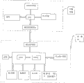
Fig. 1 is the structural representation of the preferred embodiment of interactively traffic navigation of the present invention and vehicular security system;
Fig. 2 is the synoptic diagram of interaction data between the each several part of interactively traffic navigation of the present invention and vehicular security system;
Fig. 3 is the physical arrangement figure of the user terminal in interactively traffic navigation of the present invention and the vehicular security system;
Fig. 4 is the process flow diagram of interactively traffic navigation of the present invention and vehicle-mounted safety protection method.
Embodiment
Based on technology such as GPS location and navigation, GIS, mobile communication technology (as GSM, GPRS and CDMA etc.), short distance interconnection techniques (as serial ports, infrared, Bluetooth etc.), the present invention integrates remote control center, car-mounted terminal, navigating instrument three's function, forms a kind of interactively traffic navigation and vehicular security system.Remote control center, car-mounted terminal, navigating instrument three's formation and function will be described respectively below.
Remote control center
Remote control center is made up of several parts such as call center, intelligent information system, Geographic Information System.The call center provides a close friend's interactive interface for system, and directly and car-mounted terminal carry out information communication; All geography information and data (electronic chart, peripheral information etc.), Weather information, Real-time Traffic Information (traffic accident, vehicle flowrate, block up etc.) and condition of road surface (repair the roads, ponding etc.) are integrated and analyzed to Geographic Information System, generates the succinct data about event description, weather conditions, influence degree, direction and scope, duration, path planning suggestion etc.; The result data of automatic standard of intelligent information system and storage Geographic Information System, and provide the data support for the call center.
Car-mounted terminal
Car-mounted terminal utilizes equipment such as its handle, mobile communication module, GPS locating module, and direct and remote control center is realized the location and the safety guard work of vehicle alternately.Wherein mobile communication module can be taked mobile communications such as GSM, GRPS or CDMA.Because car-mounted terminal has mobile communication function,, realize its service function so also can by its data-interface, utilize navigating instrument rich functions and close friend's user interface and control center mutual only as a communications intermediary with navigating instrument.Data-interface between car-mounted terminal and the navigating instrument can adopt wireless connect technologies such as wired connection technology such as 232 serial ports or Bluetooth to realize.
Navigating instrument
Navigating instrument carries functions such as static GPS navigation, audio-visual broadcast, and the interface (can adopt wireless connect technologies such as wired connection technology such as 232 serial ports or Bluetooth to realize) that carries out data transmission with car-mounted terminal is arranged.The navigating instrument user can use the navigation feature of the static state that navigating instrument carries, and the data that can only accept control center's transmission are implemented the GPS navigation of passive type, also can implement the Interactive Dynamic navigation alternately with the center.Simultaneously, navigating instrument can receive and show function informations such as vehicle-mounted security protection, phone, note, and handles and demonstration control center result data.
In interactively traffic navigation and vehicular security system, independently car-mounted terminal and navigating instrument are formed user terminal by data-interface (wired or wireless connected mode), and user terminal is mutual by mobile communications network (GSM, GPRS, CDMA etc.) and remote control center.
In a preferred embodiment of the invention, the basis that is applied as with GPS location and navigation, GIS, GPRS/GSM communication network, Bluetooth wireless connect technology, on the basis of existing static navigation and on-vehicle safety protection Long-distance Control, remote control center, vehicle-mounted security protection and the triplicity of intelligent navigation instrument are got up, constitute interactively traffic navigation and vehicular security system, its architecture as shown in Figure 1.
Navigating instrument is realized integrated the connection to form user terminal with car-mounted terminal (being car among Fig. 1) by Bluetooth, be positioned at the continuous emission space information of gps satellite of space, the GPS receiver module that is installed in user terminal receives satellite information, signal by the processor processing GPS receiver module of user terminal is exported therefrom extracts data such as needed Position, Velocity and Time.At this moment, user terminal can utilize its existing electronic chart to finish static navigation feature.
Remote control center by GPRS/GSM with the various real time data dynamic transmission of central integration to user terminal, subscriber terminal equipment can utilize its GPS navigation function that carries to realize the passive type dynamic navigation in conjunction with these data, also can feed back to control center, carry out information communication with it, realize Interactive Dynamic navigation and security protection.
In the Interactive Dynamic navigation and safety-protection system that the present invention proposes, user terminal can feed back it after receiving real-time dynamic data, proposes its individual character requirement to remote control center.After remote control center is received the feedback information of user terminal, utilize that it is concentrated, powerful data processing function and broadness, perfect, real-time information resources, be user's path planning, handle individual demand etc., and directly service is offered the user.
As shown in Figure 2, the synoptic diagram of interaction data between each several part in the navigation of the interactively dynamic type of the present invention and the safety-protection system.Its systemic-function effect is described below:
Navigating instrument and car-mounted terminal are formed by the Bluetooth wireless connect technology can free mutual user terminal.Navigating instrument can obtain GPRS/GSM (as phone, note, the safeguard information etc.) function of car-mounted terminal by image demonstration and voice prompting mode, and can be by the various functions on touch-screen direct control and the use car-mounted terminal.
The information gathering point set in the various places, city collected real time traffic data, transferring to remote control center utilization GIS and intelligent information handling system puts in order and stores data, in the cartographic information of center, add real-time traffic and data such as condition of road surface, meteorology, news and music, then the raw information of integration and real-time update control center.
The location of navigating instrument and ride, path requirement, security protection and other personalized " user profile " such as the demands GPRS/GSM by car-mounted terminal with data upload to remote control center.
The user profile that the navigating instrument user uploads is accepted and handled in real time to remote control center, utilize the powerful data processing function and complete, abundant, the real-time information resources at center, the user profile that the information and the navigating instrument user at center uploaded combines carries out overall treatment, for the terminal user integrates path planning, divides " service recommendations " such as flow path direction, alternative route, security protection layouts.
" service recommendations " that remote control center will be integrated be visual or voice messaging as one, and the GPRS communication function by car-mounted terminal offers the terminal user.
Describe as can be seen from top data flow, interactively security protection and dynamic vehicle navigation system that the present invention proposes, its advantage mainly show as following some:
1, navigating instrument both can separate use with car-mounted terminal, also can realize integrated connection.
2, former ride terminal user can enjoy more friendly interactive interfaces such as dynamic demonstration, voice suggestion, touch control.
3, navigating instrument is connected alternately with remote control center, but its data of real-time update, and the more full and accurate data that can directly use control center to provide, needn't take himself resource.
4, remote control center is concentrated and all resources of integration system, makes that the information of system is more perfect, and data are more accurate, and function is more powerful, simultaneously, also can lower system cost, expanding system data accumulation scope.
5, the terminal user only need claim, and need not to plan in person and handle various data, can directly enjoy the service of specialty.
The preferred embodiments of the present invention utilize various hardware, software and agreement to realize the Interactive Dynamic navigation under the overall architecture of architecture shown in Figure 1.Mainly focus on the integrated realization of user terminal.
In a preferred embodiment of the invention, the physics realization of the car-mounted terminal of user terminal and navigating instrument be connected as shown in Figure 3.Car-mounted terminal is core with the high-speed CPU, communicates with GPS module, mobile module, Bluetooth module and handle respectively by the serial ports expansion technology.The GPS module is mainly used in to be handled the signal that antenna receives and passes to CPU, finally obtains the longitude and latitude of deckhead position, realizes the accurate location of ride; Mobile module is used for GSM/GPRS/CDMA short message and telephone service, and realization is communicated by letter with remote control center; The navigating instrument that the Bluetooth module is used for and has the Bluetooth function communicates; Handle then is used for dialing, the demonstration short message of car-mounted terminal and operates other control commands, makes car-mounted terminal separate use with navigating instrument.In addition, car-mounted terminal is selected CPLD (Complex Programmable LogicDevice for use, the complex programmable logic controller) a plurality of number of I O interfaces of expansion are used for the detection of automobile oil circuit, alarm detection, lamp detection, lock Throttle Opening Control and other security protections control.
Navigating instrument adopts based on dual-CPU architecture, based on one 32 bit processor (as Samsung 2410), one 16 bit processor (as MSP430) is auxilliary, carry out that high speed signal is handled and with ride between communicate by letter, simultaneously, adopt multi-disc Synchronous DRAM (synchronous dynamic random access memory) (as HY57V561620) to constitute 128M or higher internal memory, to guarantee the system high-speed operation.The GPS resume module receives the GPS locating information, and it is transferred to CPU.CPU can carry out data processing in conjunction with softwares such as map, calculating.The operating system (as WINCE) of navigating instrument operation is writable in Flash (flash memory) or micro harddisk.Simultaneously, navigating instrument also disposes input-output device such as touch-screen, SD (safe digital memory card) card and USB (USB (universal serial bus)) interface, and the feasible system upgrading reaches the exchanges data with other equipment.
The agreement that user terminal uses comprises that mainly these agreements are linked up for system information foundation is provided as host-host protocols such as GPRS communication protocol, gps satellite reception agreement, Bluetooth standard, standard usb interfaces.
Software mainly comprises navigation software, interface drive software and assistant software etc.Navigation software comprises GPS locating and displaying, analogue navigation and true navigation, destination retrieval and zone or functions such as classification retrieval, multidate information data processing, decoding and path planning; The interface drive software comprises drive softwares such as SD card, USB and AV input and output, links for main frame and peripheral hardware provide; Assistant software refers to realize the broadcast of video display, music, and picture browsing, e-book such as consult at the software of multiple function.
The invention provides a kind of interactively traffic navigation and vehicle-mounted safety protection method, as shown in Figure 4, this method comprises the steps:
User terminal uses the button on the navigating instrument touch-screen, sends " services request " to remote control center, and " services request " can select manual service or automated intelligent service;
Remote control center accepts request, and replys " acceptance service ", sets up user terminal and is connected with service between remote control center;
User terminal from the data such as Position, Velocity and Time that gps satellite extracts, is uploaded to remote control center with it, realizes the safety guard function of vehicle;
Remote control center is sent to user terminal with the real-time traffic and the dynamic datas such as condition of road surface, meteorology, news and music of its acquisition, upgrades the data of user terminal;
The user proposes individual character about " path planning " to control center and requires (purpose, the shortest time is preferential, avoid ground etc.), and the dynamic data that remote control center sends is provided feedback and estimates suggestion;
Remote control center receives and process user demand and suggestion in real time, with " path planning " result who integrates, as a visual or voice messaging, offers the terminal user;
If the terminal user is to the service satisfactory of remote control center, then this finishes the mutual of itself and control center, implements dynamic navigation according to real time data, otherwise, with its suggestions and requests feedback, the operation of repetition 5,6 continues mutual, until the target that reaches the terminal user.
In the present invention; navigating instrument and car-mounted terminal user are mutual with remote control center at any time in navigation procedure by mobile communications network and short distance interconnection technique; in time exchange and obtain and renewal real-time navigation and safeguard information; and by remote control center design navigation and security protection scheme; but the vehicle-mounted security protection and the dynamic navigation of real realization remote interaction; both terminal user's safety of life and property can be protected, individual and social resources can be saved again.
Claims (10)
1, a kind of interactively traffic navigation and vehicular security system comprise remote control center and user terminal, it is characterized in that,
Described remote control center comprises and is used to integrate with analytical information and generates the Geographic Information System of related data, be used for the intelligent information system that automatic standard and storage provide data to support from the result data of described Geographic Information System and for the call center, and the call center that is used to provide interactive interface, carries out information communication with user terminal;
Described user terminal comprises car-mounted terminal and navigating instrument, described car-mounted terminal comprises CPU, a GPS module, mobile communication module and first data interface module, and described CPU communicates with a GPS module, mobile communication module, first data interface module respectively by the serial ports expansion technology;
A described GPS module is used to handle and receives the signal that obtains and send it to CPU;
Described mobile communication module is used for communicating with remote control center;
Described first data interface module is used for communicating with the navigating instrument that has the corresponding data interface;
Described navigating instrument comprises based on dual-CPU architecture, the 2nd GPS module, storer, second data interface module and input-output device, and described car-mounted terminal is realized integrated the connection with navigating instrument by data interface module;
Described car-mounted terminal is by mobile communications network and described remote control center interactive information.
2, interactively traffic navigation according to claim 1 and vehicular security system is characterized in that, described data-interface comprises wireless data interface and cable data interface; Described wireless data interface comprises blue-teeth data interface and infrared data interface; Described cable data interface comprises RS232 serial data interface.
3, interactively traffic navigation according to claim 2 and vehicular security system is characterized in that, described car-mounted terminal also comprises handle, and described navigating instrument also comprises input and output control.
4, interactively traffic navigation according to claim 3 and vehicular security system is characterized in that, the described CPU in the described car-mounted terminal communicates by serial ports expansion technology and described handle;
Described handle in the described car-mounted terminal is used for operation control car-mounted terminal.
5, interactively traffic navigation according to claim 4 and vehicular security system is characterized in that, described car-mounted terminal also comprises the complex programmable logic controller, are used to expand a plurality of IO interface to realize the security protection control of automobile.
6, interactively traffic navigation according to claim 5 and vehicular security system is characterized in that, the road detection of described security protection controlling packet oil scraper, alarm detection, lamp detect and the lock Throttle Opening Control.
7, interactively traffic navigation according to claim 1 and vehicular security system is characterized in that, the described based on dual-CPU architecture in the described navigating instrument is used to carry out signal Processing, and communicate by described second data interface module and car-mounted terminal;
Described the 2nd GPS module in the described navigating instrument is used to handle the GPS locating information that reception obtains, and sends it to CPU;
Described storer in the described navigating instrument comprises flash memory and/or micro harddisk, is used for the operating system of burning navigating instrument operation;
Described input-output device in the described navigating instrument comprises touch-screen, safe digital memory card and USB (universal serial bus).
8, interactively traffic navigation according to claim 1 and vehicular security system is characterized in that, described mobile communications network comprises GSM, GPRS and CDMA.
9, according to each described interactively traffic navigation and vehicular security system in the claim 1-7, it is characterized in that the data flow in the system comprises:
1) the free interactive information of navigating instrument and car-mounted terminal;
2) remote control center is integrated and real-time update raw information;
3) user terminal is uploaded user profile to remote control center;
4) remote control center receives and real-time process user information, and the raw information in conjunction with remote control center is integrated into service recommendations;
5) remote control center offers user terminal with service recommendations with the form of visual information and/or voice messaging.
10, a kind of interactively traffic navigation and vehicle-mounted safety protection method, car-mounted terminal and integrated user terminal and the remote control center interactive information that is connected the back formation of navigating instrument is characterized in that described interactive information comprises the steps:
1) user terminal sends " services request " to remote control center;
2) remote control center accepts request, and replys " acceptance service ", and the service of setting up between user terminal and the remote control center connects;
3) user terminal with its data upload of extracting from gps satellite to remote control center;
4) remote control center is sent to user terminal with the dynamic data of its acquisition, upgrades the data of user terminal;
5) user terminal proposes the individual character requirement to remote control center, and the dynamic data that remote control center sends is provided feedback and estimates suggestion;
6) remote control center receives and process user demand and suggestion in real time, with " service recommendations " result of integrating as one visual and/or voice messaging, offer user terminal;
7) if user terminal, is then finished the mutual of itself and control center to the service satisfactory of remote control center, implement dynamic navigation according to real time data, otherwise, with its suggestions and requests feedback, repeating step 5) and the operation of step 6) continue alternately, until the target that reaches user terminal.
Priority Applications (1)
| Application Number | Priority Date | Filing Date | Title |
|---|---|---|---|
| CNB2006101570277A CN100533503C (en) | 2006-11-23 | 2006-11-23 | An interactive traffic navigation and vehicular security system |
Applications Claiming Priority (1)
| Application Number | Priority Date | Filing Date | Title |
|---|---|---|---|
| CNB2006101570277A CN100533503C (en) | 2006-11-23 | 2006-11-23 | An interactive traffic navigation and vehicular security system |
Publications (2)
| Publication Number | Publication Date |
|---|---|
| CN1967615A CN1967615A (en) | 2007-05-23 |
| CN100533503C true CN100533503C (en) | 2009-08-26 |
Family
ID=38076367
Family Applications (1)
| Application Number | Title | Priority Date | Filing Date |
|---|---|---|---|
| CNB2006101570277A Expired - Fee Related CN100533503C (en) | 2006-11-23 | 2006-11-23 | An interactive traffic navigation and vehicular security system |
Country Status (1)
| Country | Link |
|---|---|
| CN (1) | CN100533503C (en) |
Families Citing this family (10)
| Publication number | Priority date | Publication date | Assignee | Title |
|---|---|---|---|---|
| CN101183011B (en) * | 2007-12-27 | 2011-08-31 | 深圳市赛格导航科技股份有限公司 | GPS navigation method and system |
| CN101806597B (en) * | 2009-02-13 | 2012-12-12 | 深圳市赛格导航科技股份有限公司 | Intelligent information system-based remote interactive navigation method and system |
| CN101881621B (en) * | 2009-05-07 | 2012-10-03 | 深圳市赛格导航科技股份有限公司 | Omnibearing security and real-time navigation system supporting source sharing |
| JP5448626B2 (en) * | 2009-07-31 | 2014-03-19 | クラリオン株式会社 | Navigation device, server device, and navigation system |
| CN102117547A (en) * | 2009-12-31 | 2011-07-06 | 上海博泰悦臻电子设备制造有限公司 | Business processing method of vehicle service system |
| US8731627B2 (en) * | 2011-04-04 | 2014-05-20 | General Motors Llc | Method of using a smart phone as a telematics device interface |
| CN102975632A (en) * | 2011-09-02 | 2013-03-20 | 杭州鸿泉数字设备有限公司 | Vehicle remote management control achieving device |
| CN102853841A (en) * | 2012-05-08 | 2013-01-02 | 龚䶮 | Man-machine interaction method of navigator |
| CN103884349A (en) * | 2014-02-21 | 2014-06-25 | 武汉无懈科技有限责任公司 | Evaluation-based navigation method |
| CN105466450A (en) * | 2015-11-21 | 2016-04-06 | 广西南宁至简至凡科技咨询有限公司 | GPS-based train journey measuring system |
-
2006
- 2006-11-23 CN CNB2006101570277A patent/CN100533503C/en not_active Expired - Fee Related
Also Published As
| Publication number | Publication date |
|---|---|
| CN1967615A (en) | 2007-05-23 |
Similar Documents
| Publication | Publication Date | Title |
|---|---|---|
| CN100533503C (en) | An interactive traffic navigation and vehicular security system | |
| CN108230734B (en) | Outdoor wisdom parking system based on V2X communication | |
| CN102187178B (en) | For the method for green route selection, device and map data base | |
| RU2571450C2 (en) | Method of multimodal navigation | |
| US9830817B2 (en) | Bus station optimization evaluation method and system | |
| CN1963394B (en) | A dynamic intelligent navigation method | |
| CN101135725B (en) | Method for tracing navigation system and tracing navigation | |
| CN101976505A (en) | Traffic evaluation method and system | |
| CN104167092A (en) | Method and device for determining taxi pick-up and drop-off hot spot region center | |
| CN202444622U (en) | Weather forecast and disaster pre-warning system for vehicular information services | |
| CN104316068A (en) | Method, device and system for navigation of electric automobile | |
| CN101086806A (en) | A system and method for onboard terminal based on traffic information grid platform | |
| CN103914991A (en) | Vehicle position sharing method | |
| CN105702041A (en) | Highway multisource data fusion state estimation system based on neural network and method thereof | |
| CN105466435A (en) | Route planning method and device for navigation system | |
| CN101114836A (en) | System and method for vehicle mounted terminal to issue traffic information gridding service | |
| CN105679009A (en) | Taxi-taking/order-receiving POI recommendation system and method based on taxi GPS data mining | |
| CN109121070A (en) | A kind of underground parking bluetooth layout and localization method | |
| CN101881621B (en) | Omnibearing security and real-time navigation system supporting source sharing | |
| CN109874109A (en) | Mobile unit and its service information pushing method | |
| CN104992572A (en) | An automobile traffic restriction warning intelligent management system | |
| CN102768797B (en) | A kind of urban road condition information evaluation method and device | |
| Fantian et al. | Review of the key technologies and applications in internet of vehicle | |
| KR20000036661A (en) | The bilateral action remote service process for geographical map & it including system & the mobile communication terminal that use it | |
| CN101304291A (en) | Mobile phone advices plate and use method thereof |
Legal Events
| Date | Code | Title | Description |
|---|---|---|---|
| C06 | Publication | ||
| PB01 | Publication | ||
| C10 | Entry into substantive examination | ||
| SE01 | Entry into force of request for substantive examination | ||
| C14 | Grant of patent or utility model | ||
| GR01 | Patent grant | ||
| CF01 | Termination of patent right due to non-payment of annual fee | ||
| CF01 | Termination of patent right due to non-payment of annual fee |
Granted publication date: 20090826 |