EP0818692A1 - Method for determining the absolute value of the velocity of a radar carrier - Google Patents
Method for determining the absolute value of the velocity of a radar carrier Download PDFInfo
- Publication number
- EP0818692A1 EP0818692A1 EP97401684A EP97401684A EP0818692A1 EP 0818692 A1 EP0818692 A1 EP 0818692A1 EP 97401684 A EP97401684 A EP 97401684A EP 97401684 A EP97401684 A EP 97401684A EP 0818692 A1 EP0818692 A1 EP 0818692A1
- Authority
- EP
- European Patent Office
- Prior art keywords
- radar
- ground
- speed
- carrier
- image
- Prior art date
- Legal status (The legal status is an assumption and is not a legal conclusion. Google has not performed a legal analysis and makes no representation as to the accuracy of the status listed.)
- Granted
Links
Images


Classifications
-
- G—PHYSICS
- G01—MEASURING; TESTING
- G01S—RADIO DIRECTION-FINDING; RADIO NAVIGATION; DETERMINING DISTANCE OR VELOCITY BY USE OF RADIO WAVES; LOCATING OR PRESENCE-DETECTING BY USE OF THE REFLECTION OR RERADIATION OF RADIO WAVES; ANALOGOUS ARRANGEMENTS USING OTHER WAVES
- G01S13/00—Systems using the reflection or reradiation of radio waves, e.g. radar systems; Analogous systems using reflection or reradiation of waves whose nature or wavelength is irrelevant or unspecified
- G01S13/02—Systems using reflection of radio waves, e.g. primary radar systems; Analogous systems
- G01S13/50—Systems of measurement based on relative movement of target
- G01S13/58—Velocity or trajectory determination systems; Sense-of-movement determination systems
- G01S13/60—Velocity or trajectory determination systems; Sense-of-movement determination systems wherein the transmitter and receiver are mounted on the moving object, e.g. for determining ground speed, drift angle, ground track
-
- G—PHYSICS
- G01—MEASURING; TESTING
- G01S—RADIO DIRECTION-FINDING; RADIO NAVIGATION; DETERMINING DISTANCE OR VELOCITY BY USE OF RADIO WAVES; LOCATING OR PRESENCE-DETECTING BY USE OF THE REFLECTION OR RERADIATION OF RADIO WAVES; ANALOGOUS ARRANGEMENTS USING OTHER WAVES
- G01S13/00—Systems using the reflection or reradiation of radio waves, e.g. radar systems; Analogous systems using reflection or reradiation of waves whose nature or wavelength is irrelevant or unspecified
- G01S13/88—Radar or analogous systems specially adapted for specific applications
- G01S13/89—Radar or analogous systems specially adapted for specific applications for mapping or imaging
- G01S13/90—Radar or analogous systems specially adapted for specific applications for mapping or imaging using synthetic aperture techniques, e.g. synthetic aperture radar [SAR] techniques
Definitions
- the present invention relates to airborne radars or on board satellites.
- This process has the advantage of not involving the setting of the radar compared to its carrier because it does not require knowledge precise pointing angle of the radar with respect to the reference trihedron of the wearer, nor that of the drift angle of the wearer with respect to his path. This results in an increase in the accuracy of the measurement.
- the speed of the wearer is obtained either at using a satellite navigation system (GPS), or using radar operating in a special mode called speed vector determination ground.
- GPS satellite navigation system
- radar operating in a special mode called speed vector determination ground.
- FIG. 2 illustrates the operating principle of an airborne radar operating in mode for determining the speed vector of its carrier.
- the radar placed at the front point of an aircraft 20 performs two lateral sightings of the ground with large deposits - ⁇ 1 and ⁇ 2 and at very low site ⁇ .
- the beam 21 of the radar illuminates a portion of the ground which returns an echo affected by a frequency drift F D ⁇ 1 linked to the Doppler effect due to the component V 1 of the horizontal speed of the carrier in the direction targeted by the relationship:
- V 1 radar ⁇ F D ⁇ 1 2cos ⁇
- the beam 22 of the radar illuminates another portion of ground which returns an echo affected by 'a frequency drift F d ⁇ 2 linked to the Doppler effect due to the component V 2 of the horizontal speed of the carrier in the direction targeted by the relationship:
- V 2 radar ⁇ F D ⁇ 2 2cos ⁇
- the orientation of the ground speed vector is not necessarily confused with the longitudinal axis of the aircraft 21 because there may be, as is the case shown in FIG. 2, a heading drift angle - ⁇ due crosswind.
- this method of determination gives the direction of the ground speed of the aircraft, this independently of the drift.
- it implements a priori knowledge of the deposits - ⁇ 1 and ⁇ 2 of the directions targeted and possibly of the site ⁇ , if the latter is not negligible, which takes into account radar setting errors. relative to the aircraft reference system, which affects the accuracy of the measurement.
- FIG. 3 illustrates this lighting process, by a radar carried by an aircraft 30, from the same point P on the ground, in two successive instants t 1 and t 2 .
- the aircraft 30 follows a rectilinear trajectory c.
- time t 1 when its radar illuminates point P of the ground for the first time, it is at point A of its trajectory c with a drift angle ⁇ ; he sees the point P of the ground at a distance D 1 and under a deposit G 1 .
- time t 2 when its radar illuminates point P on the ground for the second time, it has reached point B on its trajectory c with the same drift angle ⁇ and sees point P on the ground at a new distance D 2 and under a new G 2 deposit.
- This expression of the ground speed of the radar carrier presents the advantage of no longer involving a deposit and therefore of making the measurement independent of the radar setting on its carrier and the heading drift of the carrier.
- the Doppler offset frequency measurement precision is generally chosen such that the resolution of the image is isotropic, or a radial resolution (along the distance axis) equal to the transverse resolution (axis Doppler frequencies).
- the accuracy on the distance measurement between two points of the image goes from 200 m to 7 m.
- the method for evaluating the modulus of the ground speed of the carrier of a radar which has just been described for a 2D radar, is generalized to radars 3D, either by using the information of the differences channels in the case of 3D interferometric modes, either by using a digital file describing the altitude of the terrain in the case of 3D modes with digital file of ground.
Abstract
Description
La présente invention concerne les radars aéroportés ou embarqués à bord de satellites.The present invention relates to airborne radars or on board satellites.
Lorsqu'un radar aéroporté fonctionne en mode imagerie (SAR), la conformité de l'image à la réalité dépend de la précision avec laquelle est connu le module de la vitesse de déplacement du porteur du radar. Une imprécision dans la connaissance du module de la vitesse du radar se traduit par une déformation de l'image qui altère les mesures de distance faites dans cette image. Pour obtenir des mesures de distance précises sur une image radar, on est donc contraint de connaítre le module de la vitesse de déplacement du porteur d'une manière extrêmement précise.When an airborne radar is operating in imagery (SAR) mode, the conformity of the image to reality depends on the precision with which is known the modulus of the speed of movement of the radar carrier. A imprecision in the knowledge of the speed module of the radar translated by a distortion of the image which alters the distance measurements do in this picture. For accurate distance measurements on a radar image, we are therefore forced to know the modulus of the speed of movement of the carrier in an extremely precise manner.
Dans la technique antérieure, il est habituel de déterminer la vitesse de déplacement du porteur, soit à l'aide du radar lui-même qui fonctionne alors dans un mode spécifique de mesure du vecteur vitesse du porteur, différent du mode imagerie et faisant intervenir le calage du radar par rapport à son porteur, soit à l'aide d'un équipement distinct du radar comme un système de navigation par satellites (GPS) ou, si sa précision le permet, la centrale inertielle.In the prior art, it is usual to determine the speed of movement of the carrier, either using the radar itself which then operates in a specific mode for measuring the velocity vector of the carrier, different from imaging mode and involving radar calibration relative to its carrier, either using equipment separate from the radar as a satellite navigation system (GPS) or, if its accuracy allows, the inertial unit.
On se propose ici, de déterminer le module de la vitesse de déplacement du porteur d'un radar à l'aide du seul radar lui même, sans faire intervenir le calage de celui-ci par rapport à son porteur, et indépendamment de la dérive du porteur due à un éventuel vent de travers, afin d'améliorer la précision de la mesure et d'éviter la nécessité du recours à un autre système que le radar lui-même.We propose here to determine the modulus of the speed of movement of the speed camera holder using the speed camera alone, without involve the timing thereof relative to its carrier, and regardless of the wearer's drift due to a possible crosswind, in order to improve the accuracy of the measurement and avoid the need for recourse to a system other than the radar itself.
La présente invention a pour objet un procédé de détermination du module de la vitesse de déplacement du porteur d'un radar consistant à :
- éclairer latéralement avec le radar une même zone du sol à deux instants différents t1 et t2,
- mesurer les distances D1 et D2, et les décalages de fréquence Doppler Fd1 et Fd2 des échos retournés par un même point de la zone du sol observée au cours des deux instants t1 et t2, et
- déduire le module
- laterally illuminate the same area of the ground with the radar at two different times t 1 and t 2 ,
- measure the distances D 1 and D 2 , and the Doppler frequency offsets F d1 and F d2 of the echoes returned by the same point of the ground area observed during the two instants t 1 and t 2 , and
- deduct module
Ce procédé a l'avantage de ne pas faire intervenir le calage du radar par rapport à son porteur car il ne nécessite pas la connaissance précise de l'angle de pointage du radar par rapport au trièdre de référence du porteur, ni celle de l'angle de dérive du porteur par rapport à sa trajectoire. Il en résulte une augmentation de la précision de la mesure.This process has the advantage of not involving the setting of the radar compared to its carrier because it does not require knowledge precise pointing angle of the radar with respect to the reference trihedron of the wearer, nor that of the drift angle of the wearer with respect to his path. This results in an increase in the accuracy of the measurement.
D'autres caractéristiques et avantages de l'invention ressortiront de la description ci-après d'un mode de mise en oeuvre donné à titre d'exemple. Cette description sera faite en regard du dessin dans lequel :
- une figure 1 est un schéma illustrant la façon d'éclairer latéralement une zone du sol par un radar aéroporté pour en prendre une image,
- une figure 2 est un schéma illustrant la manière habituelle d'estimer la vitesse sol au moyen d'un radar aéroporté, et
- une figure 3 est un schéma illustrant la manière, selon l'invention, d'estimer le module de la vitesse sol au moyen d'un radar aéroporté.
- FIG. 1 is a diagram illustrating the way of lateral lighting an area of the ground by an airborne radar in order to take an image thereof,
- FIG. 2 is a diagram illustrating the usual way of estimating the ground speed by means of an airborne radar, and
- FIG. 3 is a diagram illustrating the way, according to the invention, of estimating the modulus of the ground speed by means of an airborne radar.
Un dispositif d'imagerie par effet Doppler utilise la dépendance de
la fréquence Doppler en fonction du gisement ou écart angulaire de la zone
visée par rapport à l'axe de déplacement du porteur pour former une image.
La prise de vue est latérale car un radar en mode imagerie est aveugle dans
l'axe de déplacement de son porteur. Comme on peut le voir sur la figure 1,
le radar est supposé placé en pointe avant d'un aéronef 10 qui se déplace
au-dessus du sol avec une vitesse horizontale Vh. Il vise latéralement par
rapport à l'aéronef 10, une zone à cartographier 11 située à une distance D,
à un gisement G et à un site -S. L'écho renvoyé par le centre de cette zone
11 est affecté d'un retard τ proportionnel à sa distance D et d'un décalage
en fréquence Fd due à l'effet Doppler vérifiant les relations :

- c, la vitesse de propagation des ondes hyperfréquence du radar,
- λ, la longueur d'onde des ondes hyperfréquence du radar.
- c, the speed of propagation of the microwave waves of the radar,
- λ, the wavelength of the radar microwave waves.
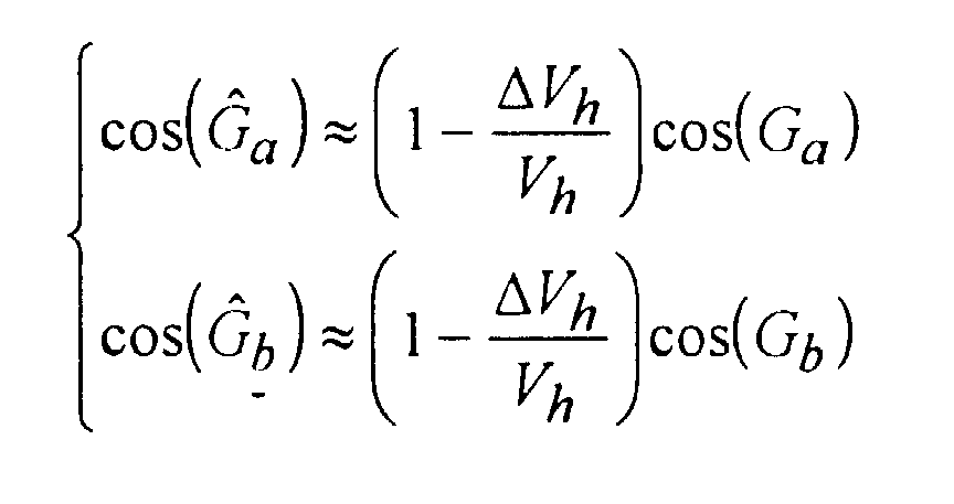
Soit ΔVh l'erreur commise sur l'estimation V andh de la vitesse
horizontale du porteur :

L'erreur sur la vitesse horizontale du porteur étant faible, on peut
écrire :
Si l'on s'intéresse à la distance r entre les deux points de l'image,
celle-ci s'écrit :
L'erreur Δr commise sur la distance entre les deux points de
l'image :


Par exemple, si l'on commet une erreur de 1 % sur la vitesse horizontale de déplacement du porteur, celle-ci se traduit sur une mesure de distance entre deux points éloignés transversalement de 10 km et distants du radar de 100 km à un gisement moyen de 45°, par une erreur de l'ordre de 200 m.For example, if you make a 1% error on the speed horizontal movement of the carrier, this results in a measurement of distance between two points transversely distant 10 km and distant 100 km radar at an average bearing of 45 °, due to an error of the order 200 m.
Pour diminuer cette erreur de mesure sur la distance entre deux points d'une image radar, il faut améliorer la précision sur la vitesse du porteur. Dans le scénario ci-dessus, pour que l'erreur de distance soit inférieure à 10 m, on doit connaítre la vitesse du porteur à moins de 0,05 % près, ce qui est très difficile.To reduce this measurement error on the distance between two points of a radar image, it is necessary to improve the precision on the speed of the carrier. In the above scenario, for the distance error to be less than 10 m, we must know the speed of the carrier less than 0.05% close, which is very difficult.
Dans la technique antérieure, la vitesse du porteur s'obtient soit à l'aide d'un système de navigation par satellite (GPS), soit à l'aide du radar fonctionnant dans un mode spécial dit de détermination du vecteur vitesse sol.In the prior art, the speed of the wearer is obtained either at using a satellite navigation system (GPS), or using radar operating in a special mode called speed vector determination ground.
La figure 2 illustre le principe de fonctionnement d'un radar
aéroporté fonctionnant en mode de détermination du vecteur vitesse de son
porteur. Le radar placé en pointe avant d'un aéronef 20 effectue deux visées
latérales du sol à gisements importants -α1 et α2 et à très faible site β. Au
cours de la première visée, qui a lieu, par exemple du côté gauche de
l'aéronef, au gisement -α1, le faisceau 21 du radar illumine une portion du
sol qui retourne un écho affecté d'une dérive en fréquence FDα1 liée à l'effet
Doppler dû à la composante V1 de la vitesse horizontale du porteur dans la
direction visée par la relation :
Il est intéressant de profiter du fait que, dans une mesure de distance entre deux points d'une image radar, il est inutile de connaítre la direction de la vitesse sol du porteur et d'utiliser ce fait pour rechercher un mode de fonctionnement du radar en détermination du seul module de la vitesse sol ne faisant pas entrer en ligne de compte les erreurs de calage du radar par rapport au référentiel de l'aéronef, cela afin d'améliorer la précision de la mesure et de rendre inutile le recours à un système de navigation par satellites.It is interesting to take advantage of the fact that, to an extent distance between two points of a radar image, there is no need to know the direction of the wearer's ground speed and use this fact to look for a radar operating mode in determining the only module of the ground speed not taking timing errors into account radar in relation to the aircraft reference system, this in order to improve the accuracy of the measurement and making it unnecessary to use a system of satellite navigation.
Pour ce faire, on propose d'éclairer latéralement avec le radar, un même point du sol en deux instants successifs t1 et t2 décalés d'un intervalle de temps T et d'effectuer, à chacun de ces instants, les mesures des distances D1 et D2,, et des décalages de fréquence Doppler Fd1 et Fd2 des échos correspondants. To do this, it is proposed to illuminate laterally with the radar, the same point on the ground at two successive instants t 1 and t 2 offset by a time interval T and to carry out, at each of these instants, the measurements of the distances D 1 and D 2 ,, and Doppler frequency shifts F d1 and F d2 of the corresponding echoes.
Pour la suite, on supposera, dans un but de simplification, que l'angle de site -S sous lequel est vu le point illuminé du sol est très faible, au plus quelques degrés, et peut avoir son cosinus approché sans inconvénient par la valeur 1.For the rest, we will assume, for the sake of simplification, that the angle of site -S under which the illuminated point of the ground is seen is very small, at plus a few degrees, and can have its cosine approached without inconvenience by the value 1.
La figure 3 illustre ce processus d'éclairement, par un radar porté
par un aéronef 30, d'un même point P du sol, en deux instants successifs t1
et t2. L'aéronef 30 suit une trajectoire rectiligne c. A l'instant t1, lorsque son
radar éclaire le point P du sol pour la première fois, il est au point A de sa
trajectoire c avec un angle de dérive δ; il voit le point P du sol à une
distance D1 et sous un gisement G1. A l'instant t2, lorsque son radar éclaire
le point P du sol pour la deuxième fois, il est parvenu au point B de sa
trajectoire c avec le même angle de dérive δ et voit le point P du sol à une
nouvelle distance D2 et sous un nouveau gisement G2.FIG. 3 illustrates this lighting process, by a radar carried by an
Le décalage Doppler Fd2 de l'écho consécutif à l'éclairement du
point P du sol au deuxième instant t2 répond à la relation :


Cette expression de la vitesse sol du porteur du radar présente l'intérêt de ne plus faire intervenir de gisement et donc de rendre la mesure indépendante du calage du radar sur son porteur et de la dérive de cap du porteur.This expression of the ground speed of the radar carrier presents the advantage of no longer involving a deposit and therefore of making the measurement independent of the radar setting on its carrier and the heading drift of the carrier.
L'expression précédente ne donne pas exactement la vitesse sol du porteur du radar mais sa composante selon le site de la visée. Cela ne présente pas d'inconvénient pour la détermination de la distance entre deux points d'une image radar, dans la mesure où c'est cette composante qui intervient dans les calculs.The previous expression does not give the ground speed exactly of the radar carrier but its component according to the site of the sighting. This presents no disadvantage for determining the distance between two points of a radar image, insofar as it is this component which is involved in the calculations.
L'écart-type des erreurs de mesure du module de la vitesse sol du
porteur du radar par mise en oeuvre de la relation (6) est donné par la
formule suivante :

Or, pour un radar d'imagerie, la précision de mesure de fréquence
de décalage Doppler est généralement choisie telle que la résolution de
l'image soit isotrope, soit une résolution radiale (selon l'axe distance) égale
à la résolution transverse (axe des fréquences Doppler). L'écart-type de la
mesure de fréquence de décalage Doppler vaut alors
Si de plus l'intervalle de temps T entre les deux instants de
mesure t1 et t2 est assez court pour que les distances et les fréquences de
décalage Doppler aient peu varié, l'expression de la précision de la mesure
de vitesse se simplifie :
Cette précision sur la vitesse permet d'obtenir une précision de
mesure de distance sur une image, dont l'écart-type σr déduit de la relation
(3) en négligeant la dérive vaut :

En considérant une précision de mesure de distance radar-cible de 1 m, une vitesse du porteur du radar de 200 m/s et en supposant que les deux images d'une même zone du sol soient réalisées à 10 s d'intervalle, la précision sur la mesure de distance entre deux points de l'image passe de 200 m à 7 m.By considering a radar-target distance measurement accuracy 1 m, a speed of the radar carrier of 200 m / s and assuming that the two images of the same area of the ground are taken at 10 s intervals, the accuracy on the distance measurement between two points of the image goes from 200 m to 7 m.
On peut réduire la durée de l'intervalle de temps séparant les deux prises de vue d'une même zone tout en conservant la même précision de mesure, en utilisant plusieurs points de réflexion dans l'image pour estimer la vitesse sol du porteur. On fait alors autant d'évaluations de la vitesse sol du porteur qu'il y a de points de réflexion pris en compte et l'on fait la moyenne de ces évaluations ce qui améliore la précision. Dans l'exemple ci-dessus, l'utilisation de 100 points de réflexion au lieu d'un permet de ramener l'intervalle de temps de 10 s à 1 s, pour la même précision. We can reduce the duration of the time interval separating the two shots of the same area while maintaining the same precision measurement, using multiple reflection points in the image to estimate the ground speed of the carrier. We then do as many evaluations of the ground speed of the carrier that there are reflection points taken into account and averages these ratings which improves accuracy. In the example above, using 100 reflection points instead of a reduces the time interval from 10 s to 1 s, for the same precision.
On peut remarquer que l'acquisition des signaux nécessaires à la formation de l'image Radar, par une technique SAR par exemple, et celle des mesures nécessaires à l'estimation du module de la vitesse peuvent être effectuées dans le même temps. Ceci permet d'effectuer les meilleures corrections possibles sur les distances entre points dans l'image radar.It can be noted that the acquisition of the signals necessary for the Radar image formation, by a SAR technique for example, and that measures necessary to estimate the modulus of the speed can be performed at the same time. This allows the best possible corrections on the distances between points in the radar image.
Le procédé d'évaluation du module de la vitesse sol du porteur d'un radar qui vient d'être décrit pour un radar 2D, se généralise aux radars 3D, soit en utilisant les informations des voies différences dans les cas des modes 3D interférométriques, soit en utilisant un fichier numérique décrivant l'altitude du terrain dans les cas des modes 3D avec fichier numérique de terrain.The method for evaluating the modulus of the ground speed of the carrier of a radar which has just been described for a 2D radar, is generalized to radars 3D, either by using the information of the differences channels in the case of 3D interferometric modes, either by using a digital file describing the altitude of the terrain in the case of 3D modes with digital file of ground.
Claims (3)
Applications Claiming Priority (2)
| Application Number | Priority Date | Filing Date | Title |
|---|---|---|---|
| FR9608733A FR2751088B1 (en) | 1996-07-12 | 1996-07-12 | METHOD FOR DETERMINING THE MODULE OF THE SPEED OF THE RADAR CARRIER |
| FR9608733 | 1996-07-12 |
Publications (2)
| Publication Number | Publication Date |
|---|---|
| EP0818692A1 true EP0818692A1 (en) | 1998-01-14 |
| EP0818692B1 EP0818692B1 (en) | 2002-01-09 |
Family
ID=9493988
Family Applications (1)
| Application Number | Title | Priority Date | Filing Date |
|---|---|---|---|
| EP97401684A Expired - Lifetime EP0818692B1 (en) | 1996-07-12 | 1997-07-11 | Method for determining the absolute value of the velocity of a radar carrier |
Country Status (4)
| Country | Link |
|---|---|
| US (1) | US5870053A (en) |
| EP (1) | EP0818692B1 (en) |
| DE (1) | DE69709496T2 (en) |
| FR (1) | FR2751088B1 (en) |
Cited By (1)
| Publication number | Priority date | Publication date | Assignee | Title |
|---|---|---|---|---|
| RU2673679C1 (en) * | 2017-10-17 | 2018-11-29 | Публичное акционерное общество "Авиационная холдинговая компания "Сухой" | Pulse-doppler radar signals digital processing device with targets by distance migration compensation |
Families Citing this family (4)
| Publication number | Priority date | Publication date | Assignee | Title |
|---|---|---|---|---|
| SE513210C2 (en) * | 1998-10-30 | 2000-07-31 | Ericsson Telefon Ab L M | Procedure for determining movement data for objects |
| FR2884617B1 (en) * | 2005-04-15 | 2007-07-06 | Alstom Belgium Sa | SYSTEM AND METHOD FOR DETERMINING THE INSTANT SPEED OF AN OBJECT. |
| FR2886020B1 (en) * | 2005-05-19 | 2007-10-19 | Eurocopter France | SPEED ESTIMATING SYSTEM OF AN AIRCRAFT AND ITS APPLICATION TO DETECTION OF OBSTACLES |
| EP3394616B1 (en) | 2015-12-24 | 2019-04-24 | Koninklijke Philips N.V. | A method and a system for determinations of cell suspensions |
Citations (2)
| Publication number | Priority date | Publication date | Assignee | Title |
|---|---|---|---|---|
| US4771287A (en) * | 1983-06-23 | 1988-09-13 | Westinghouse Electric Corp. | Method of correcting for errors in radar imaging |
| EP0406877A2 (en) * | 1989-07-07 | 1991-01-09 | Deutsches Zentrum für Luft- und Raumfahrt e.V. | Method for extracting movement errors of a carrier transporting a coherent imaging radar system from radar raw data and device for carrying out this method |
Family Cites Families (6)
| Publication number | Priority date | Publication date | Assignee | Title |
|---|---|---|---|---|
| FR2629602B1 (en) * | 1976-04-02 | 1991-09-20 | Thomson Csf | SIGNAL PROCESSING DEVICE OF A SIDE VISION RADAR, AND RADAR SYSTEM COMPRISING SUCH A DEVICE |
| FR2483086A1 (en) * | 1980-05-22 | 1981-11-27 | Martin Philippe | SIGNAL PROCESSING METHOD FOR SIDE-OPEN AND OPEN SYNTHESIZED RADAR AND IMPLEMENTATION CIRCUIT |
| US5160931A (en) * | 1991-09-19 | 1992-11-03 | Environmental Research Institute Of Michigan | Interferometric synthetic aperture detection of sparse non-surface objects |
| US5278757A (en) * | 1991-11-15 | 1994-01-11 | The Trustees Of The University Of Pennsylvania | Synthetic aperture ultrasonic imaging system using a minimum or reduced redundancy phased array |
| US5469167A (en) * | 1993-10-18 | 1995-11-21 | The United States Of America As Represented By The Secretary Of The Army | Synthetic aperture radar for nonlinear trajectories using range relative doppler processing and invariant mapping |
| FR2712095B1 (en) * | 1993-11-05 | 1995-12-22 | Europ Agence Spatiale | Method of aerial or spatial altimetric measurements, in particular intended for the altimetry of the oceans, and device implementing such a method. |
-
1996
- 1996-07-12 FR FR9608733A patent/FR2751088B1/en not_active Expired - Fee Related
-
1997
- 1997-07-10 US US08/882,392 patent/US5870053A/en not_active Expired - Fee Related
- 1997-07-11 DE DE69709496T patent/DE69709496T2/en not_active Expired - Fee Related
- 1997-07-11 EP EP97401684A patent/EP0818692B1/en not_active Expired - Lifetime
Patent Citations (2)
| Publication number | Priority date | Publication date | Assignee | Title |
|---|---|---|---|---|
| US4771287A (en) * | 1983-06-23 | 1988-09-13 | Westinghouse Electric Corp. | Method of correcting for errors in radar imaging |
| EP0406877A2 (en) * | 1989-07-07 | 1991-01-09 | Deutsches Zentrum für Luft- und Raumfahrt e.V. | Method for extracting movement errors of a carrier transporting a coherent imaging radar system from radar raw data and device for carrying out this method |
Cited By (1)
| Publication number | Priority date | Publication date | Assignee | Title |
|---|---|---|---|---|
| RU2673679C1 (en) * | 2017-10-17 | 2018-11-29 | Публичное акционерное общество "Авиационная холдинговая компания "Сухой" | Pulse-doppler radar signals digital processing device with targets by distance migration compensation |
Also Published As
| Publication number | Publication date |
|---|---|
| FR2751088A1 (en) | 1998-01-16 |
| US5870053A (en) | 1999-02-09 |
| DE69709496T2 (en) | 2002-09-26 |
| FR2751088B1 (en) | 1998-11-06 |
| DE69709496D1 (en) | 2002-02-14 |
| EP0818692B1 (en) | 2002-01-09 |
Similar Documents
| Publication | Publication Date | Title |
|---|---|---|
| FR2715724A1 (en) | A method for determining the position of an aircraft from acceleration data of an inertial system as well as from output data of a navigation system, and device. | |
| US7038612B2 (en) | Method for SAR processing without INS data | |
| FR2694638A1 (en) | A synthetic aperture image motion compensation method and device using a flight / position line reference system. | |
| US8471766B2 (en) | Method of correlating known image data of moving transmitters with measured radio signals | |
| CA2542734C (en) | System and process for determining the instantaneous velocity of an object | |
| FR2781888A1 (en) | Movement compensation system for synthetic aerial radar system includes inertial and global positioning to provide correction of data | |
| US6549165B2 (en) | Ocean altimetry interferometric method and device using GNSS signals | |
| AU2005250540B2 (en) | Testing method, and method for passively obtaining target parameters | |
| FR2545226A1 (en) | METHOD FOR DETERMINING THE POSITION OF A SEISMIC PULSE RECEIVER IMMERSAL CABLE, WHICH IS TRAILERED BY A BUILDING CREATING THESE IMPULSES | |
| US20110057839A1 (en) | Method and apparatus for passive geolocation using synthetic-aperture processing | |
| EP1782098B1 (en) | Method for an antenna angular calibration by relative distance measuring | |
| EP0818692B1 (en) | Method for determining the absolute value of the velocity of a radar carrier | |
| FR2916531A1 (en) | METHOD FOR ESTIMATING ERRORS POSITION AND SPEED OF AN INERTIAL PLATFORM USING RADAR WITH IMAGING SAR | |
| FR2750214A1 (en) | METHOD OF CALIBRATING POSITIONING ERRORS OF A RADAR AND THE FLOOR DRIFT OF AN INERTIAL PLANT EMBEDDED ABOARD AN AIRCRAFT | |
| EP1324065B1 (en) | Method for passively finding the position of a target and especially for air-air locating | |
| EP2990824B1 (en) | Sonar method and device for determining the speed of movement of a marine vehicle relative to the seabed | |
| EP0881505B1 (en) | Method of repeated position-finding for a mobile object using radar cartographie of uneven terrain | |
| EP0778471B1 (en) | Radar detection method and system | |
| EP3980720B1 (en) | Method and device for resetting an inertial unit of a transport means on the basis of information delivered by a viewfinder of the transport means | |
| FR2932570A1 (en) | METHOD AND DEVICE FOR ESTIMATING AT LEAST ONE SPEED COMPONENT OF A MOBILE TARGET | |
| EP2681579B1 (en) | Method for positioning a moving element on a radar image | |
| EP1691214A1 (en) | System for determining the absolute position of a towed or self-propelled submarine engine | |
| FR2675268A1 (en) | METHOD AND DEVICE FOR DETERMINING THE POSITION OF A TRANSPONDER BY USING A VIRTUAL SECONDARY SURVEILLANCE RADAR. | |
| FR3041766A1 (en) | PASSIVE LOCALIZATION METHOD OF ELECTROMAGNETIC GROUND EMITTERS, USE, AND DEVICE THEREOF | |
| Cantalloube et al. | Accurate geometrical model for airborne Synthetic Aperture Radar |
Legal Events
| Date | Code | Title | Description |
|---|---|---|---|
| PUAI | Public reference made under article 153(3) epc to a published international application that has entered the european phase |
Free format text: ORIGINAL CODE: 0009012 |
|
| AK | Designated contracting states |
Kind code of ref document: A1 Designated state(s): DE FR GB IT |
|
| 17P | Request for examination filed |
Effective date: 19980309 |
|
| AKX | Designation fees paid |
Free format text: DE FR GB IT |
|
| RBV | Designated contracting states (corrected) |
Designated state(s): DE FR GB IT |
|
| 17Q | First examination report despatched |
Effective date: 20001206 |
|
| GRAG | Despatch of communication of intention to grant |
Free format text: ORIGINAL CODE: EPIDOS AGRA |
|
| GRAG | Despatch of communication of intention to grant |
Free format text: ORIGINAL CODE: EPIDOS AGRA |
|
| GRAH | Despatch of communication of intention to grant a patent |
Free format text: ORIGINAL CODE: EPIDOS IGRA |
|
| GRAH | Despatch of communication of intention to grant a patent |
Free format text: ORIGINAL CODE: EPIDOS IGRA |
|
| RAP1 | Party data changed (applicant data changed or rights of an application transferred) |
Owner name: THALES |
|
| GRAA | (expected) grant |
Free format text: ORIGINAL CODE: 0009210 |
|
| REG | Reference to a national code |
Ref country code: GB Ref legal event code: IF02 |
|
| AK | Designated contracting states |
Kind code of ref document: B1 Designated state(s): DE FR GB IT |
|
| REF | Corresponds to: |
Ref document number: 69709496 Country of ref document: DE Date of ref document: 20020214 |
|
| GBT | Gb: translation of ep patent filed (gb section 77(6)(a)/1977) |
Effective date: 20020405 |
|
| PLBE | No opposition filed within time limit |
Free format text: ORIGINAL CODE: 0009261 |
|
| STAA | Information on the status of an ep patent application or granted ep patent |
Free format text: STATUS: NO OPPOSITION FILED WITHIN TIME LIMIT |
|
| 26N | No opposition filed | ||
| PGFP | Annual fee paid to national office [announced via postgrant information from national office to epo] |
Ref country code: DE Payment date: 20090709 Year of fee payment: 13 |
|
| PGFP | Annual fee paid to national office [announced via postgrant information from national office to epo] |
Ref country code: IT Payment date: 20090722 Year of fee payment: 13 |
|
| PG25 | Lapsed in a contracting state [announced via postgrant information from national office to epo] |
Ref country code: DE Free format text: LAPSE BECAUSE OF NON-PAYMENT OF DUE FEES Effective date: 20110201 |
|
| REG | Reference to a national code |
Ref country code: DE Ref legal event code: R119 Ref document number: 69709496 Country of ref document: DE Effective date: 20110201 |
|
| PG25 | Lapsed in a contracting state [announced via postgrant information from national office to epo] |
Ref country code: IT Free format text: LAPSE BECAUSE OF NON-PAYMENT OF DUE FEES Effective date: 20100711 |
|
| PGFP | Annual fee paid to national office [announced via postgrant information from national office to epo] |
Ref country code: FR Payment date: 20110727 Year of fee payment: 15 |
|
| PGFP | Annual fee paid to national office [announced via postgrant information from national office to epo] |
Ref country code: GB Payment date: 20110706 Year of fee payment: 15 |
|
| GBPC | Gb: european patent ceased through non-payment of renewal fee |
Effective date: 20120711 |
|
| REG | Reference to a national code |
Ref country code: FR Ref legal event code: ST Effective date: 20130329 |
|
| PG25 | Lapsed in a contracting state [announced via postgrant information from national office to epo] |
Ref country code: GB Free format text: LAPSE BECAUSE OF NON-PAYMENT OF DUE FEES Effective date: 20120711 Ref country code: FR Free format text: LAPSE BECAUSE OF NON-PAYMENT OF DUE FEES Effective date: 20120731 |