EP0838764A2 - Map data base management method and system therefor - Google Patents
Map data base management method and system therefor Download PDFInfo
- Publication number
- EP0838764A2 EP0838764A2 EP97308471A EP97308471A EP0838764A2 EP 0838764 A2 EP0838764 A2 EP 0838764A2 EP 97308471 A EP97308471 A EP 97308471A EP 97308471 A EP97308471 A EP 97308471A EP 0838764 A2 EP0838764 A2 EP 0838764A2
- Authority
- EP
- European Patent Office
- Prior art keywords
- map
- region
- scale
- index
- map data
- Prior art date
- Legal status (The legal status is an assumption and is not a legal conclusion. Google has not performed a legal analysis and makes no representation as to the accuracy of the status listed.)
- Granted
Links
Images


Classifications
-
- G—PHYSICS
- G06—COMPUTING; CALCULATING OR COUNTING
- G06T—IMAGE DATA PROCESSING OR GENERATION, IN GENERAL
- G06T1/00—General purpose image data processing
-
- G—PHYSICS
- G01—MEASURING; TESTING
- G01C—MEASURING DISTANCES, LEVELS OR BEARINGS; SURVEYING; NAVIGATION; GYROSCOPIC INSTRUMENTS; PHOTOGRAMMETRY OR VIDEOGRAMMETRY
- G01C21/00—Navigation; Navigational instruments not provided for in groups G01C1/00 - G01C19/00
- G01C21/38—Electronic maps specially adapted for navigation; Updating thereof
- G01C21/3863—Structures of map data
- G01C21/387—Organisation of map data, e.g. version management or database structures
- G01C21/3881—Tile-based structures
-
- Y—GENERAL TAGGING OF NEW TECHNOLOGICAL DEVELOPMENTS; GENERAL TAGGING OF CROSS-SECTIONAL TECHNOLOGIES SPANNING OVER SEVERAL SECTIONS OF THE IPC; TECHNICAL SUBJECTS COVERED BY FORMER USPC CROSS-REFERENCE ART COLLECTIONS [XRACs] AND DIGESTS
- Y10—TECHNICAL SUBJECTS COVERED BY FORMER USPC
- Y10S—TECHNICAL SUBJECTS COVERED BY FORMER USPC CROSS-REFERENCE ART COLLECTIONS [XRACs] AND DIGESTS
- Y10S707/00—Data processing: database and file management or data structures
- Y10S707/99931—Database or file accessing
- Y10S707/99932—Access augmentation or optimizing
-
- Y—GENERAL TAGGING OF NEW TECHNOLOGICAL DEVELOPMENTS; GENERAL TAGGING OF CROSS-SECTIONAL TECHNOLOGIES SPANNING OVER SEVERAL SECTIONS OF THE IPC; TECHNICAL SUBJECTS COVERED BY FORMER USPC CROSS-REFERENCE ART COLLECTIONS [XRACs] AND DIGESTS
- Y10—TECHNICAL SUBJECTS COVERED BY FORMER USPC
- Y10S—TECHNICAL SUBJECTS COVERED BY FORMER USPC CROSS-REFERENCE ART COLLECTIONS [XRACs] AND DIGESTS
- Y10S707/00—Data processing: database and file management or data structures
- Y10S707/99941—Database schema or data structure
- Y10S707/99943—Generating database or data structure, e.g. via user interface
-
- Y—GENERAL TAGGING OF NEW TECHNOLOGICAL DEVELOPMENTS; GENERAL TAGGING OF CROSS-SECTIONAL TECHNOLOGIES SPANNING OVER SEVERAL SECTIONS OF THE IPC; TECHNICAL SUBJECTS COVERED BY FORMER USPC CROSS-REFERENCE ART COLLECTIONS [XRACs] AND DIGESTS
- Y10—TECHNICAL SUBJECTS COVERED BY FORMER USPC
- Y10S—TECHNICAL SUBJECTS COVERED BY FORMER USPC CROSS-REFERENCE ART COLLECTIONS [XRACs] AND DIGESTS
- Y10S707/00—Data processing: database and file management or data structures
- Y10S707/99941—Database schema or data structure
- Y10S707/99944—Object-oriented database structure
- Y10S707/99945—Object-oriented database structure processing
-
- Y—GENERAL TAGGING OF NEW TECHNOLOGICAL DEVELOPMENTS; GENERAL TAGGING OF CROSS-SECTIONAL TECHNOLOGIES SPANNING OVER SEVERAL SECTIONS OF THE IPC; TECHNICAL SUBJECTS COVERED BY FORMER USPC CROSS-REFERENCE ART COLLECTIONS [XRACs] AND DIGESTS
- Y10—TECHNICAL SUBJECTS COVERED BY FORMER USPC
- Y10S—TECHNICAL SUBJECTS COVERED BY FORMER USPC CROSS-REFERENCE ART COLLECTIONS [XRACs] AND DIGESTS
- Y10S707/00—Data processing: database and file management or data structures
- Y10S707/99941—Database schema or data structure
- Y10S707/99948—Application of database or data structure, e.g. distributed, multimedia, or image
Definitions
- the present invention relates to a map data base management method and a system therefor, and more particularly, to a map data base management method and a system therefor, for efficiently managing maps of various scales corresponding to one area.
- a car navigation system and geographical information system As a multimedia technology for saving man power.
- GIS geographical information system
- a car navigation system is used for finding a current position of a car using a driving distance and direction of the car.
- a data base management system (DBMS) adopted in such a car navigation system and a geographical information system still uses a binary-tree form in the structure of searching an index.
- DBMS data base management system
- a current index search method using a binary-tree structure is slow in its search speed, a map data base for various scales cannot be efficiently managed.
- some car navigation systems use a data base management system having a formalised region-tree method and a hierarchical structure, which is also show in its search speed and is difficult to adapt itself to various areas.
- a map data base management method for efficiently managing map data of various scales on an area basis and on a country basis, by searching map data of a corresponding region using a map data base in which indices are designated in the form of a hierarchical structure based on a geographical characteristic of each region.
- a map data base management method comprising the steps: (a) constructing a map index file so that with respect to regions partitioning each of maps drawn on a plurality of scales involved with the same geographical area, an individual region index is designated to a region, in the manner that a region index for designating each region constituting a relatively large-scale map determines region indices for designating a plurality of regions constituting a map of a scale just below the relatively large-scale; (b) constructing a map data file so that among regions designated by region indices in step (a), individual map data is designated by a scale and a region index, in the manner that each region having land in a corresponding scale map has corresponding map data and each region having no land in a corresponding scale map has no map data; (c) determining a region index corresponding to desired longitude and latitude and scale, using the map index file in the step (a); and (d) reading map data corresponding to the desired scale and the region index determined in the
- said map index file contains a predetermined longitude and latitude range and a predetermined scale range, and storage position and data length of map data and start region index corresponding to each scale and region index, wherein the start region index has a number which is determined by the number of regions for partitioning a map having a scale just below said each scale by which the region corresponding to said each scale and said region index is divided, and the corresponding region index.
- Said step (c) may comprise the sub-steps of: (c1) determining whether one of desired longitude and latitude and desired scale is beyond the predetermined longitude and latitude range and scale range; and (c2) determining, in sequence, a region index corresponding to the desired longitude and latitude and scale from a relatively large-scale map to a relatively small-scale map, when it is determined that the desired longitude and latitude and scale are not beyond the predetermined longitude and latitude range and scale range in the step (c1).
- Step (c2) preferably calculates the region index corresponding to the desired longitude and latitude and scale, using a longitude interval and a latitude interval indicated on a scale map with regard to each region corresponding to the desired longitude and latitude, and a corresponding start region index.
- a map data base management system comprising: a map data base storage unit for storing a map index file so that with respect to regions partitioning each of maps drawn on a plurality of scales involved with the same geographical area, an individual region index is designated to a region, in the manner that a region index for designating each region constituting a relatively large-scale map determines region indices for designating a plurality of regions constituting a map of a scale just below the relatively large-scale, and a map data file so that among regions designated by region indices, individual map data is designated by a scale and a region index, in the manner that each region having land in a corresponding scale map has corresponding map data and each region having no land in a corresponding scale map has no map data; a map management unit for determining region indices corresponding to desired longitude and latitude and a scale applied from the external, and reading the map data corresponding to the desired scale and the determined region index from the map data base storage unit to then
- Said map index file preferably contains a predetermined longitude and latitude range and a predetermined scale range, and storage position and data length of map data and start region index corresponding to each scale and region index, wherein, the start region index has a number which is determined by the number of regions for partitioning a map having a scale just below said each scale by which the region corresponding to said each scale and said region index is divided, and the corresponding region index.
- Said map management unit preferably determines whether one of desired longitude and latitude and desired scale is beyond the predetermined longitude and latitude range and scale range, and determines, in sequence, a region index corresponding to the desired longitude and latitude and scale from a relatively large-scale map to a relatively small-scale map, when it is determined that the desired longitude and latitude and scale are not beyond the predetermined longitude and latitude range and scale range.
- Said map management unit preferably calculates the region index corresponding to the desired longitude and latitude and scale, using a longitude interval and a latitude interval indicated on a scale map with regard to each region corresponding to the desired longitude and latitude, and a corresponding start region index.
- a map database management method comprising the steps of: (a) constructing a map index file in which maps of different scales for a common geographical area have inter-related region indices, whereby a region index designating a particular geographical region on a relatively large scale map is associated with region indices designating the same geographical region on a relatively smaller scale map; (b) constructing a map data file in which individual map data is designated by a scale and a region index, and allocating map data for each of the region indices corresponding to geographical regions which are land regions in a corresponding scale map and allocating no map data to region indices corresponding to geographical regions which are not land regions; and (c) detecting a user input requesting map information for a given scale and geographical region and retrieving and displaying corresponding map data to the user.
- step (c) comprises determining a region index corresponding to user input longitude, latitude and scale information using the map index file of step (a) and reading and displaying map data corresponding to the region index from the map data file of step (b).
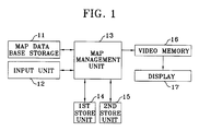
- a map data base management system includes a map data base storage unit 11 for storing map data of various scale and region indices corresponding to the map data in the form of files, and an input unit 12 for receiving a desired scale (or scale index) and longitude and latitude via an interface with a user.
- the map data base storage unit 11 is designed as a CD ROM, a hard disk drive (HDD) and a RAM card.
- a first store unit 14 and a second store 15 are connected to the map management unit 13.
- the first store unit 14 stores a program and data for managing the map data base, and is designed with a ROM.
- the second store unit 15 temporarily stores a map index file read from the map data base storage unit 11 and is designed with a RAM.
- a video memory 16 and a display 17 are connected to the map management unit 13, in order to display map data on a screen.
- scale indices for identifying maps of various scales are "1" for a complete map of Korea, "2" for a 1-to-1,200,00 map, "3” for a 1-to-200,000 map, "4" for a 1-to-100,000 map. "5" for a 1-to-500,000 map, "6” for a 1-to-25,000 map and "7” for a 1-to-5,000 map, respectively.
- Maps of various scales in which region indices are designated according to the embodiments of the present invention will be described with reference to Figures 2 through 8.
- one region index is designated for each of a number of regions constituting a map drawn on each scale so that with respect to a given geographical area, a region index involved with a relatively large-scale map corresponds to a plurality of region indices involved with a map having a scale just below the above large scale.
- a map data base is constituted so that only map data with respect to a region where land actually exists is stored after dividing a map of each scale into regions with and without land, respectively.
- two islands i.e., Dokto and Ullungdo form part of the Korean territory
- description of map data base management with respect to the above two Islands will be omitted.
- Figure 2 shows a map of Korea drawn on a scale of 1 to 50,000 in which region indices are designated according to the embodiment of the present invention.
- the horizontal line B1 indicates a latitude line and the vertical line B2 indicates a longitude line, respectively.
- "B3" indicates region indices with respect to regions having no map data
- B4 indicates region indices with respect to regions having map data.
- the region indices B3 and B4 are shown in Figure 2 as being discriminated from one another by means of double solid lines enclosing those region indices B4.
- Figure 3 shows a map of Korea drawn on a scale of 1 to 100,000 and having region indices with respect to the 1 to 100,000 map, the horizontal line C1 indicates a latitude line and the vertical line C2 indicates a longitude line, respectively.
- “C3” indicates region indices with respect to regions having no map data
- "C4" indicates region indices with respect to regions having map data.
- the region indices C3 and C4 are shown in Figure 3 as being discriminated from one another by thick solid lines enclosing region indices C4.
- Each region index shown in the Figure 3 map designates regions on a 1-to-100,000 map corresponding to a group of four region indices designated in the 1-to-50,000 map of Figure 2.
- C5 is a discrimination line illustrating the discrimination of the different type of regions corresponding to the region indices B3 and B4 on the 1-to-50,000 map of Figure 2, and the shaded areas correspond to other regions of the type B3 on the 1-to-50,000 map which contain no meaningful map data.
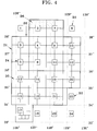
- the vertical line D1 indicates a longitude line and the horizontal line D2 indicates a latitude line, respectively.
- "D3" indicates region indices with respect to regions having no map data
- "D4" indicates region indices with respect to regions having map data.
- the region indices D3 and D4 are shown in Figure 4 as being discriminated from one another by thick solid lines enclosing region indices D4.
- reference numerals 1, 8, 18, 22, 23 and 24 are region indices of type D3.
- Each region index D3 or D4 shown in the Figure 4 map designates regions on a 1-to-200,000 map which each correspond to four region indices involved in the 1-to-100,000 map of Figure 3.
- An index D5 is a discrimination line for discriminating regions to be described in connection with the 1-to-100,000 map of Figure 3, and shaded portions as shown by index D6 indicate regions on the 1-to-100,000 map having region indices C3.
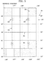
- Figure 5 shows a 1-to-1,200,000 map obtained by dividing a complete map of Korea by four and including map region indices.
- the horizontal line E1 indicates a latitude line and the vertical line E2 indicates a longitude axis, respectively.
- "E3" indicates region indices with respect to individual regions on a 1-to-1,200,000 map.
- One region on the 1-to-1,200,000 map of region indices E3 relates to four regions on the 1-to-1,200,000 map corresponding to four regions indices D3 or D4,
- "E4" is a discrimination line for discriminating regions to be described in connection with the 1-to-200,000 map, and "E5" being a shading portion shows regions indicated corresponding to the region indices D3 on a 1-to-200,000 map.
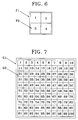
- Figure 6 shows that each region on the 1-to-50,000 map of Figure 2 corresponding to the region index B3 or B4 corresponds to four regions on a 1-to-25,000 map.
- an index F1 means each region on a 1-to-50,000 map
- an index F2 means four regions of the region F1 which has been divided into the same size and having a scale of 1-to-25,000.
- Figure 7 shows that each region on the 1-to-50,000 map of Figure 2 corresponds to 100 regions on a 1-to-5,000 map.
- G1 means a region corresponding to each region index B4 on the 1-to-50,000 map of Figure 2
- G2 means region indices corresponding to 100 regions of the region G1 which has been divided into the same size.
- Each region corresponding to the G2 has a 1-to-5,000 scale.
- Figure 8 depicts a Cheju Island area having a scale of 1-to-50,000 shown in Figure 2.
- darkened circles H1 are centre positions of six regions H2 divided from the 1-to-50,000 map of the Cheju Island area, respectively.
- the latitude and longitude of each centre position H1 is (33° 30', 126° 22' 30"), (33° 30'. 126° 37' 30"), (33° 30', 126° 52' 30"), (33° 15', 126° 15'), (33° 15', 126° 30'), and (33° 15', 126° 45').
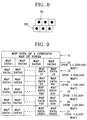
- the region index of each scale and the map data of the corresponding regions which have been described with reference to Figures 2 through 8 with respect to the complete map of Korea, are stored in advance in the map data base storage unit 11 of figure 1 in the form of a map data file and map index file to be described with reference to Figures 9 and 10.
- the map data file of Figure 9 is divided into areas I1 through I7 corresponding to scale indices 1 through 7, wherein a plurality of map data corresponding to each region index are positioned in each area.
- the area I1 designated by the scale index 1 stores the map data of the complete map of Korea.
- the area I2 designated by the scale index 2 stores the map data of the 1-to-1,200,000 map of Figure 5. Therefore, the map data corresponding to four regions of the 1-to-1,200,000 map exists in the area I2.
- the area I3 of the scale index 3 stores the map data of the regions having the map data in Figure 4, that is, the map data of 18 regions designated by the region indices D4.
- the area I4 of the scale index 4 stores the map data of the 64 regions designated by the region indices C4 among the 68 regions shown in Figure 3.
- the area I5 of the scale index 5 stores the map data of the 231 regions designated by the region indices B4 among the 262 regions shown in Figure 2.
- the area I6 of the scale index 6 stores the map data corresponding to the 729 regions having the map data when each of the 262 regions shown in Figure 2 is divided into four regions on a 1-to-25,000 map.
- the area I7 of the scale index 7 stores the map data corresponding to the 18, 225 regions having the map data when each of the 262 regions shown in Figure 2 is divided into 100 regions having the same size on a 1-to-5,000 map.
- the map index file shown in Figure 10 includes areas J1 through J9 individually corresponding to the scale indices, where the respective areas J1 through J9 store data storage positions, data lengths and start region indices of the map data file of Figure 9.
- the data storage position and the data length indicate the positions in which the map data corresponding to each of regions indices involving each scale index is stored in the map data file of Figure 9 and the lengths of the stored data, respectively.
- the start region index is a region index of a region having the lowest index value among a region on a map having a certain scale and the corresponding regions on a small scale map just less than the above scale. For example, the start region index stored in correspondence to the region index 2 on the 1-to-1,200,000 map of Figure 5 becomes the region index 7 on the 1-to-200,000 map of Figure 4.
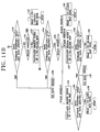
- FIG. 11A and 11B showing a flow chart diagram of a process of managing a map data base in the map management unit 13, the map management unit 13 incorporating with a central processing unit (CPU) performs a map data search according to a map data base management program stored in the first store unit 14.
- the map management unit 13 reads the map index file of Figure 10 stored in the map data base storage unit 11 and stores the read result in the second store unit 15 (step 101).
- the map management unit 13 determines whether the received longitude and latitude and scale index are contained in a predetermined longitude and latitude range and scale index range stored in an area J1 of the map index file, in order to determine whether the map data of the longitude and latitude and scale to be found by a user are supported by the Figure 1 system (step 103). When one of the received longitude and latitude and the scale index is beyond a corresponding predetermined range, the map management unit 13 processes this case as a boundary error (step 104).
- the map management unit 13 determines whether the received scale index is "1" (step 105).
- the map management unit 13 reads the map data of a complete map of Korea from the map data base storage unit 11, using the storage position where the map data of the complete map of Korea is stored and the map data length information which are contained in the area J3 of the map index file stored in the second store unit 15, when the received scale index is "1" (step 106). Then, the map management unit 13 displays the map data of the complete map of Korea on the display 17 via the video memory 16 so that a user can see it.
- the map management unit 13 calculates the region index involving the 1-to-1,200,000 map using the input longitude and latitude and the following equations (1) (step 107).
- Longitude offset Integer [X-125° 35')/2°
- Latitude offset Integer [(39° - Y)/3°
- Region index Latitude offset x2 + longitude offset +1
- X and Y are the input longitude and latitude, respectively.
- the 125° 35' and 39° are the longitude and latitude of a predetermined reference position in connection with the map of Korea, and 2° and 3° are a longitude interval and a latitude interval in each region formalized in the Figure 5 map.
- constants 2 and 1 in the region index calculation equation are a numerical difference in the region indices 3 and 2 to the latitude and longitude directions with respect to the start region index whose value is 1 in the Figure 5 map, respectively.
- the input latitude is 38° and the longitude is 127° as an example using the above equation (1)
- a longitude offset and a latitude offset of the 1-to-1,200,000 map are both zero.
- the value of the region index corresponding to the input longitude and latitude is 1.
- the map management unit 13 determines whether the value of the input scale index is 2 (step 108). When the value of the scale index is 2, the map management unit 13 determines the data storage position and the length information corresponding to the input scale index and the region index calculated in the step 107 among the data contained in the area J4 of the map index file stored in the second store unit 15, and reads the corresponding map data from the map data file stored in the map data base storage unit 11 using the determined data storage position and the length information (step 109). Then, the map management unit 13 displays the read map data on the display 17 via the video memory 16 so that user can see it.
- the map mangement unit 13 calculates the region index corresponding to the input longitude using the following equations (2), with respect to the formalized 1-to-200,000 map described with reference to Figure 4 (step 110).
- Longitude offset Integer[((X-125° 35') -longitude offset of 1:1,200,000 mapx2° )/1° ]
- Latitude offset Integer[((39° -Y) -latitude offset of 1:1,200,00 mapx3° )/1° ]
- Region index Latitude offset x2 + longitude offset + start region index
- the 2° and 3° in the equation (2) are a longitude interval and a latitude interval in each region of the formalized Figure 5 map, respectively.
- the 1° indicated in the denominator is a longitude interval and latitude interval in each region of the formalized Figure 4 map, respectively.
- the factor 2 and 1 indicated in the right-hand side of the region index calculation equation are differences in number to the latitude and longitude directions with respect to the region index 1, respectively. Since each region index in the 1-to-1,200,000 map correspond to six region indices in the 1-to-200,00 map, the start region index in the 1-to-200,000 map corresponding to each region index in the 1-to-1,200,000 map becomes (corresponding region index of 1-to-1,200,000 map)x6-5).
- the start region index is stored in the corresponding position of the area J4.
- step 110 the region index of the longitude and latitude in the Figure 4 1-to-200,000 map is calculated using the equations (2), the map management unit 13 determines whether the data storage position corresponding to the calculated region index is null and the data length is defined as 0, using the corresponding data contained in the area J5 of the map index file stored in the second store unit 15 (step 111). This is because the region index is designated even in the region having no map data in the 1-to-200,000 map as described in connection with Figure 4. The map management unit 13 processes the case that the data storage position and the data length corresponding to the calculated region index are null and zero respectively as a data non-existence error (step 112).
- the map management unit 13 determines whether the input scale index is 3 (step 113).
- the map management unit 13 reads the corresponding map data from the map data base storage unit 11 (step 114), using the data storage position and the data length corresponding to the region index contained in the area J5 of the map index file and calculated in step 110. Then, the map management unit 13 displays the read map data on the display 17 via the video memory 16 so that a user can see it.
- the map management unit 13 determines whether the calculated region index is 17 of a region index of the Cheju Island area (step 115).
- the map management unit 13 determines whether the input scale index is 4 (step 116). If so, since there is no map data in the 1-to-100,000 map with respect to the Cheju Island area, the map management unit 13 processes it as the data non-existence error (step 112).
- the map management unit 13 calculates the region index corresponding to the input longitude and latitude, using the 1-to-50,000 map of the Cheju Island described with reference to Figure 8 (step 117).
- the region index with respect to the informalised Cheju Island in the 1-to-50,000 map of step 117 is calculated as follows:
- the region index becomes one of the indices 257 through 262 of the indices of Figure 2.
- the map management unit 13 calculates the region index in the 1-100,000 map described with reference to Figure 3 corresponding to the input longitude and latitude, using the following equation (3) involving the longitude offset, the latitude offset and the region index of the 1-to-100,000 map (step 118).
- Longitude offset Integer[((X-125° 35') - longitude offset of 1:1,200,000 map x 2° - longitude offset of 1:200,000 map x 1° )/30']
- Latitude offset Integer [((39° - Y) - latitude offset of 1:1,200,000 map x 3° - latitude offset of 1:200,000 map x 1° )/30']
- Region index Latitude offset x2 + longitude offset + start region index
- the 30' indicated in the denominator in the equations (3) is a longitude interval and latitude interval in each region of the formalized Figure 3 1-to-100,000 map, respectively.
- the start region index used in calculation of the region index in the 1-to-100,000 map has the following relationship with respect to the region indices of the 1-to-200,000 map:
- the longitude offset of the 1-to-100,000 map is 0 ⁇ integer[((127° - 125° 35')-0X2°-1X1°)/30'] ⁇
- the latitude offset is 0 ⁇ integer[((39°-38°)-0X3°- 1X1°)/30'].
- the map management unit 13 determines whether the data storage position corresponding to the calculated region index is null and the data length is defined as 0, using the corresponding data contained in the area J6 of the map index file stored in the second store unit 15 (step 119). This is because the region index is designated even in the region having no map data in the 1-to-100,000 map as described in connection with Figure 3.
- the map management unit 13 processes the case that the data storage position and the data length corresponding to the calculated region index are null and zero, respectively, as a data non-existence error (step 120)
- the map management unit 13 determines whether the input scale index is 4 (step 121). When the input scale index is 4, the map management unit 13 reads the corresponding map data from the map data base storage unit 11, using the data storage position and the data length corresponding to the region index defined in the area J6 of the map index file stored in the second store unit 15 and calculated in step 118 (step 122). Then, the map management unit 13 displays the read map data on the display 17 via the video memory 16 so that the user can see it.
- the map management unit 13 calculates the region index corresponding to the input longitude and latitude, using the 1-to-50,000 map described with reference to Figure 8 using the following equation (4) involving the longitude offset, the latitude offset and the region index of the 1-to-50,000 map (step 123).
- Longitude offset Integer[((X-125° 35') - longitude offset of 1:1,200,000 map x2° - longitude offset of 1:200,000 map x 1° - longitude offset of 1:100,000 map x 30')/15']
- Latitude offset Integer[((39° -Y) - latitude offset of 1:1,200,000 map x 3° - latitude offset of 1:200,000 map x 1° - latitude offset of 1:100,000 map x 30')/15']
- Region index Latitude offset x 2 + longitude offset + start region index
- the 15' indicated in the denominator of the longitude and latitude offset calculation equation (4) is a longitude interval and latitude interval in each region of the 1-to-500,000 map of Figure 2, respectively.
- the region index in the 1-to-50,000 map has the following relationship with respect to the region indices of the 1-to-100,000 map:
- the map management unit 13 determines whether the data storage position corresponding to the calculated region index is null and the data length is defined as 0, using the corresponding data contained in the area J7 of the Figure 10 map index file stored in the second store unit 15 (step 124). This is because the region index is designated even in the region having no map data in the 1-to-50,000 map as described in connection with Figure 2.
- the map management unit 13 processes the case that the data storage position and the data length corresponding to the calculated region index are null and zero, respectively, as a data non-existence error (step 120).
- the map management unit 13 determines which of 5,6 and 7 is the input scale index (step 125).
- the map management unit 13 reads the corresponding map data from the map data base storage unit 11 which stores the map data file (step 126), using the data storage position and the data length corresponding to the region index calculated in step 123 or step 117, which are defined in the area J7 of the map index file stored in the second store unit 15. Then, the map management unit 13 displays the read map data on the display 17 via the video memory 16 so that user can see it.
- step 127 the map management unit 13 determines whether the region index calculated in step 117 or 123 is the region index involving the 1-to-50,000 map of the Cheju Island area (step 127).
- the map management unit 13 can be modified to determine whether it belongs to the Cheju Island area using the input longitude and latitude.
- the map management unit 13 calculates the region index in the 1-to-25,000 map corresponding to the input longitude and latitude, using the following equation (5).
- Longitude offset Integer [((X-125° 35') - longitude offset of 1:1,200,000 map x 2° - longitude offset of 1:200,000 map x 1° - longitude offset of 1:100,000 map x 30' - longitude offset of 1:50,000 map x 15')/7'30"]
- Latitude offset Integer [((39° -Y) - latitude offset of 1:1,200,000 map x 3° - latitude offset of 1:200,000 map x 1° - latitude offset of 1:100,000 map x 30' - latitude offset of 1:50,000 map x 15')/7'30"]
- Region index Latitude offset x 10 + longitude offset + start region index
- the 7' 30" indicated in the denominators of the longitude and latitude offset calculation equations (5) are a longitude interval and latitude interval in the region corresponding to each region index involving the 1-to-25,000 map, respectively. Also, since the region indices involving the 1-to-25,000 map are formalized in the form where four region indices correspond to one region index involving the 1-to-50,000 map, the start region index of the 1-to-25,000 map becomes the corresponding region index of the 1-to-50,000 map x 4-3.
- the map management unit 13 determines whether the region index calculated in connection with the 1-to-50,000 map belongs to which one of a class of 157 through 259 and the other class of 260 through 262. If the calculated region index is one of 257 through 259, the map management unit 13 calculates the region index on the 1-to-25,000 map corresponding to the input longitude and latitude, using the following equations (6).
- the map management unit 13 calculates the region index on the 1-to-25,000 map corresponding to the input longitude and latitude, using the following equations (7).
- Longitude offset Integer[((X-126° 7' 30") -(region index of 1:50,000 map -260)x15')/7' 30"]
- Latitude offset Integer [((33° 22' 30" - Y)/7' 30"]
- Region index Latitude offset x2 + longitude offset + start region index
- the region indices of the 1 to 25,000 map from the 1025 to 1048 can be obtained.
- the map management unit 13 determines whether the data storage position corresponding to the calculated region index is null and the data length is defined as 0, from the area J8 of the map index file stored in the second store unit 15 (step 128). If the data storage position and the data length are null and zero, respectively, the map management unit 13 processes it as a data non-existence error (step 129).
- the map management unit 13 reads the data storage position and the data length corresponding to the region index calculated in step 127 from the area J8 of the map index file stored in the second store unit 15. Using the data storage position and the length information, the map management unit 13 reads the map data corresponding to the map data file stored in the map data base storage unit 11 (step 130). Then, the map management unit 13 displays the read map data on the display 17 via the video memory 16 so that user can see it.
- the map management unit 13 determines whether the region index calculated in step 117 or 123 is the region index involving the 1-to-50,000 map of the Cheju Island. When the input scale index is determined that it is not the region index of the Cheju Island region, the map management unit 13 calculates the region index in the 1-to-5,000 map corresponding to the input longitude and latitude and described with reference to Figure 7, using the following equations (8) (step 131).
- Longitude offset Integer [((X-125° 35') - longitude offset of 1:1,200,000 map x2° - longitude offset of 1:200,000 map x1° - longitude offset of 1:100,000 map x 30' - longitude offset of 1:50,000 map x 15')/1' 30"]
- Latitude offset Integer [((39° -Y) - latitude offset of 1:1,200,000 map x3° - latitude offset of 1:200,000 map x1° - latitude offset of 1:100,000 map x 30' - latitude offset of 1:50,000 map x15')/1' 30"]
- Region index Latitude offset x 10 + longitude offset + start region index
- the 1' 30" indicated in the denominators of the longitude and latitude offset calculation equation (8) are a longitude interval and a latitude interval in the region corresponding to each region index of the 1 to 5,000 map, respectively. Also, since the region indices involving the 1-to-5,000 map are formalized in the form where 100 region indices correspond to one region index involving the 1-to-50,000 map, the start region index of the 1 to 5,000 map becomes the corresponding region index of the 1 to 50,000 mapx100-99.
- the map management unit 13 determines whether the region index calculated in connection with the 1-to-50,000 map belongs to which one of a class of 257 through 259 and the other class of 260 through 262. If the calculated region index is one of 257 through 259, the map management unit 13 calculates the region index on the 1-to-5,000 map of Cheju Island corresponding to the input longitude and latitude, using the following equations (9).
- the map management unit 13 calculates the region index of the 1-to-5,000 map using the following equation (10).
- Longitude offset Integer[((X-126° 7' 30") - (region index of 1:50,000 map -260)x15')/1' 30"]
- Latitude offset Integer[((33° 22' 30"-Y)/1' 30"]
- Region index Latitude offset x10 + longitude offset + start region index
- the map management unit 13 determines whether the data storage position corresponding to the calculated region index is null and the data length is defined as 0, among the data storage positions and the data lengths stored in the area J9 of the map index file stored in the second store unit 15 (step 132). This is because the region index exists even in the region having no map data of the 1-to-5,000 map. If the data storage position and the data length are null and zero, respectively, the map management unit 13 processes it as a data non-existence error (step 129).
- the map management unit 13 determines the data storage position and the data length corresponding to the region index calculated in step 132 among the data stored in the area J9 of the map index file of the second store unit 15. Using the determined data storage position and the length information, the map management unit 13 reads the map data from the map data file stored in the map data base storage unit 11 (step 133). Then, the map management unit 13 displays the read map data on the display 17 via the video memory 16 so that user can see it.
- the map data base management method and the system therefor manages the map data involving the maps of various scales via the formalized index structure and the hierarchical structure.
- the size of the map index file can be minimized and the search of the map data can be simply performed via simple calculation.
- a region is classified into one having land and the other having no land in each scale, which can enable constitution of the map data base with only geographically useful map data.
- a map data base can be efficiently constructed.
Abstract
Description
start region index=corresponding region index of the 1-to-200,000 map x 4-3-8;
start region index=corresponding region index of the 1-to-200,000 map x4-3-16; and
no start region index exists.
Claims (10)
- A map data base management method comprising the steps:(a) constructing a map index file so that with respect to regions partitioning each of maps drawn on a plurality of scales involved with the same geographical area, an individual region index is designated to a region, in the manner that a region index for designating each region constituting a relatively large-scale map determines region indices for designating a plurality of regions constituting a map of a scale just below the relatively large-scale;(b) constructing a map data file so that among regions designated by region indices in step (a), individual map data is designated by a scale and a region index, in the manner that each region having land in a corresponding scale map has corresponding map data and each region having no land in a corresponding scale map has no map data;(c) determining a region index corresponding to desired longitude and latitude and scale, using the map index file in the step (a); and(d) reading map data corresponding to the desired scale and the region index determined in the step (c) from the map data file in the step (b), and displaying the read map data.
- The map data base management method according to claim 1, wherein said map index file contains a predetermined longitude and latitude range and a predetermined scale range, and storage position and data length of map data and start region index corresponding to each scale and region index,
wherein the start region index has a number which is determined by the number of regions for partitioning a map having a scale just below said each scale by which the region corresponding to said each scale and said region index is divided, and the corresponding region index. - The map data base management method according to claim 2, wherein said step (c) comprises the sub-steps of:(c1) determining whether one of desired longitude and latitude and desired scale is beyond the predetermined longitude and latitude range and scale range; and(c2) determining, in sequence, a region index corresponding to the desired longitude and latitude and scale from a relatively large-scale map to a relatively small-scale map, when it is determined that the desired longitude and latitude and scale are not beyond the predetermined longitude and latitude range and scale range in the step (c1).
- The map data base management method according to claim 3, wherein step (c2) calculates the region index corresponding to the desired longitude and latitude and scale, using a longitude interval and a latitude interval indicated on a scale map with regard to each region corresponding to the desired longitude and latitude, and a corresponding start region index.
- A map data base management system comprising:a map data base storage unit (11) for storing a map index file so that with respect to regions partitioning each of maps drawn on a plurality of scales involved with the same geographical area, an individual region index is designated to a region, in the manner that a region index for designating each region constituting a relatively large-scale map determines region indices for designating a plurality of regions constituting a map of a scale just below the relatively large-scale, anda map data file so that among regions designated by region indices, individual map data is designated by a scale and a region index, in the manner that each region having land in a corresponding scale map has corresponding map data and each region having no land in a corresponding scale map has no map data;a map management unit (13) for determining region indices corresponding to desired longitude and latitude and a scale applied from the external, and reading the map data corresponding to the desired scale and the determined region index from the map data base storage unit to then output the read data; anda display unit (17) for displaying the map data output from said map management unit (13).
- The map data base management system according to claim 5, wherein said map index file contains a predetermined longitude and latitude range and a predetermined scale range, and storage position and data length of map data and start region index corresponding to each scale and region index,
wherein, the start region index has a number which is determined by the number of regions for partitioning a map having a scale just below said each scale by which the region corresponding to said each scale and said region index is divided, and the corresponding region index. - The map data base management system according to claim 6, wherein said map management unit (13) determines whether one of desired longitude and latitude and desired scale is beyond the predetermined longitude and latitude range and scale range, and
determines, in sequence, a region index corresponding to the desired longitude and latitude and scale from a relatively large-scale map to a relatively small-scale map, when it is determined that the desired longitude and latitude and scale are not beyond the predetermined longitude and latitude range and scale range. - The map data base management system according to claim 7, wherein said map management unit (13) calculates the region index corresponding to the desired longitude and latitude and scale, using a longitude interval and a latitude interval indicated on a scale map with regard to each region corresponding to the desired longitude and latitude, and a corresponding start region index.
- A map database management method comprising the steps of:(a) constructing a map index file in which maps of different scales for a common geographical area have inter-related region indices, whereby a region index designating a particular geographical region on a relatively large scale map is associated with region indices designating the same geographical region on a relatively smaller scale map;(b) constructing a map data file in which individual map data is designated by a scale and a region index, and allocating map data for each of the region indices corresponding to geographical regions which are land regions in a corresponding scale map and allocating no map data to region indices corresponding to geographical regions which are not land regions; and(c) detecting a user input requesting map information for a given scale and geographical region and retrieving and displaying corresponding map data to the user.
- A method according to claim 9, wherein step (c) comprises determining a region index corresponding to user input longitude, latitude and scale information using the map index file of step (a) and reading and displaying map data corresponding to the region index from the map data file of step (b).
Applications Claiming Priority (2)
| Application Number | Priority Date | Filing Date | Title |
|---|---|---|---|
| KR1019960047806A KR100219161B1 (en) | 1996-10-23 | 1996-10-23 | Map database management system using map data index |
| KR9647806 | 1996-10-23 |
Publications (3)
| Publication Number | Publication Date |
|---|---|
| EP0838764A2 true EP0838764A2 (en) | 1998-04-29 |
| EP0838764A3 EP0838764A3 (en) | 1999-08-11 |
| EP0838764B1 EP0838764B1 (en) | 2004-06-09 |
Family
ID=19478618
Family Applications (1)
| Application Number | Title | Priority Date | Filing Date |
|---|---|---|---|
| EP97308471A Expired - Lifetime EP0838764B1 (en) | 1996-10-23 | 1997-10-23 | Map data base management method and system therefor |
Country Status (5)
| Country | Link |
|---|---|
| US (1) | US6125367A (en) |
| EP (1) | EP0838764B1 (en) |
| JP (1) | JP2991290B2 (en) |
| KR (1) | KR100219161B1 (en) |
| CN (1) | CN1150475C (en) |
Cited By (6)
| Publication number | Priority date | Publication date | Assignee | Title |
|---|---|---|---|---|
| WO2000002011A2 (en) * | 1998-07-03 | 2000-01-13 | Siemens Aktiengesellschaft | Method for storing and outputting a digital road map and navigation system |
| WO2001022281A1 (en) * | 1999-09-20 | 2001-03-29 | Addressworks Limited | Method and system for maintaining geographic data |
| WO2001050437A1 (en) * | 1999-12-30 | 2001-07-12 | Robert Bosch Gmbh | Method for operating a navigation system |
| WO2002075593A1 (en) * | 2001-03-17 | 2002-09-26 | Digi-Data Technologies Limited | Digital library for georeferenced maps |
| US7072642B2 (en) | 2000-11-28 | 2006-07-04 | Ntt Docomo, Inc. | Receiving device and repeating device |
| US7966301B2 (en) * | 2003-05-09 | 2011-06-21 | Planeteye Company Ulc | System and method for employing a grid index for location and precision encoding |
Families Citing this family (26)
| Publication number | Priority date | Publication date | Assignee | Title |
|---|---|---|---|---|
| JP2001109760A (en) * | 1999-10-06 | 2001-04-20 | Toshiba Corp | Device for displaying geographical information and storage medium with program executing the same stored therein |
| US7246109B1 (en) * | 1999-10-07 | 2007-07-17 | Koninklijke Philips Electronics N.V. | Method and apparatus for browsing using position information |
| JP3922857B2 (en) * | 1999-12-13 | 2007-05-30 | パイオニア株式会社 | Navigation system |
| EP1266282B1 (en) * | 2000-03-17 | 2010-04-21 | Microsoft Corporation | System and method for non-uniform scaled mapping |
| US6424933B1 (en) * | 2000-03-17 | 2002-07-23 | Vicinity Corporation | System and method for non-uniform scaled mapping |
| US6571242B1 (en) * | 2000-07-25 | 2003-05-27 | Verizon Laboratories Inc. | Methods and systems for updating a land use and land cover map using postal records |
| US7689621B1 (en) * | 2000-11-06 | 2010-03-30 | Navteq North America, Llc | Multi-dimensional spatial index for a geographic database |
| US6618736B1 (en) * | 2001-03-09 | 2003-09-09 | Ensim Corporation | Template-based creation and archival of file systems |
| JP5035493B2 (en) * | 2001-03-28 | 2012-09-26 | 栗田工業株式会社 | Water treatment equipment provision system |
| KR100472203B1 (en) * | 2002-12-12 | 2005-03-10 | 한국전자통신연구원 | Fast image processing system and method thereof |
| CN100392646C (en) * | 2003-05-13 | 2008-06-04 | 私立逢甲大学 | Simple map and data searching system thereof |
| US20040243945A1 (en) * | 2003-05-30 | 2004-12-02 | International Business Machines Corporation | Representing a storage subsystem logical configuration in a graphical user interface using a tree metaphor |
| KR100982058B1 (en) * | 2003-10-20 | 2010-09-13 | 엘지전자 주식회사 | Method for managing map data of a vehicle |
| US7373473B2 (en) * | 2004-03-10 | 2008-05-13 | Leica Geosystems Hds Llc | System and method for efficient storage and manipulation of extremely large amounts of scan data |
| US7619913B2 (en) * | 2004-11-30 | 2009-11-17 | Hewlett-Packard Development Company, L.P. | Device, method and program for managing area information |
| CN101162149B (en) * | 2006-11-30 | 2011-10-26 | 厦门雅迅网络股份有限公司 | Method for realizing remote map guidance data rapid renewing of networking vehicle mounted guidance terminal |
| CN101162152B (en) * | 2006-12-06 | 2012-01-11 | 厦门雅迅网络股份有限公司 | Processing method for realizing map displaying in networking vehicle mounted guidance terminal |
| CN101533524B (en) * | 2008-03-10 | 2012-01-18 | 北京中科通图信息技术有限公司 | Method for superimposing lines and surfaces |
| CN102027468B (en) * | 2008-05-16 | 2014-04-23 | 上海惠普有限公司 | Provisioning a geographical image for retrieval |
| US8587617B2 (en) * | 2009-02-04 | 2013-11-19 | Raytheon Company | Apparatus and method for map zooming |
| CN101976239A (en) * | 2010-09-19 | 2011-02-16 | 北京腾瑞万里科技有限公司 | Method and device for searching geographical object information |
| CN102760377B (en) * | 2011-04-29 | 2014-03-19 | 黄桂芝 | Large scale topographical map surveying and mapping method utilizing rotating TIN (triangulated irregular network) and distance and included angle dual-weight interpolation method |
| US20160170620A1 (en) * | 2013-08-02 | 2016-06-16 | Zag Holdings Inc. | Systems and methods for presenting summary information associated with map elements |
| KR102124657B1 (en) | 2013-10-29 | 2020-06-18 | 팅크웨어(주) | Apparatus and method for processing map data by real time index creation and system thereof |
| CN103605533B (en) * | 2013-10-30 | 2017-02-08 | 四川长虹电器股份有限公司 | Method for rapidly loading map data |
| CN110990431A (en) * | 2019-08-19 | 2020-04-10 | 四川长虹电器股份有限公司 | Method for realizing synchronous linkage carousel of China map and line graph data |
Citations (2)
| Publication number | Priority date | Publication date | Assignee | Title |
|---|---|---|---|---|
| US5030117A (en) * | 1987-09-25 | 1991-07-09 | Delorme David M | Digital global map generating system |
| US5445524A (en) * | 1994-05-03 | 1995-08-29 | Jones; John A. | Geographic location identification system |
Family Cites Families (18)
| Publication number | Priority date | Publication date | Assignee | Title |
|---|---|---|---|---|
| FR2461305B1 (en) * | 1979-07-06 | 1985-12-06 | Thomson Csf | MAP INDICATOR SYSTEM MORE PARTICULARLY FOR AIR NAVIGATION |
| US4513377A (en) * | 1981-06-11 | 1985-04-23 | Nippondenso Co., Ltd. | Vehicle-mounted navigator |
| DE3474607D1 (en) * | 1983-03-09 | 1988-11-17 | Nippon Denso Co | Map display system |
| JPH0690596B2 (en) * | 1985-04-30 | 1994-11-14 | 日本電装株式会社 | Electronic map display |
| CA1277043C (en) * | 1985-07-25 | 1990-11-27 | Marvin S. White, Jr. | Apparatus storing a representation of topological structures and methods of building and searching the representation |
| US4873513A (en) * | 1987-08-26 | 1989-10-10 | Geodisplay Technology Limited Partnership | Automated map display system |
| JPH03244081A (en) * | 1990-02-21 | 1991-10-30 | Nec Corp | Map retrieval system |
| US5274560A (en) * | 1990-12-03 | 1993-12-28 | Audio Navigation Systems, Inc. | Sensor free vehicle navigation system utilizing a voice input/output interface for routing a driver from his source point to his destination point |
| US5696684A (en) * | 1991-07-04 | 1997-12-09 | Robert Bosch Gmbh | Electronic guide device |
| JP2644935B2 (en) * | 1991-07-25 | 1997-08-25 | 株式会社日立製作所 | Terrain information processing method and device |
| US5199072A (en) * | 1992-02-03 | 1993-03-30 | Motorola, Inc. | Method and apparatus for restricting access within a wireless local area network |
| DE69301308T2 (en) * | 1992-02-18 | 1996-05-23 | Evans & Sutherland Computer Co | IMAGE TEXTURING SYSTEM WITH THEME CELLS. |
| JPH0660298A (en) * | 1992-08-12 | 1994-03-04 | Daikei:Kk | Navigation system |
| JP2629559B2 (en) * | 1993-05-28 | 1997-07-09 | セイコーエプソン株式会社 | In-vehicle television device and in-vehicle FM transmitter device |
| JPH07181890A (en) * | 1993-12-22 | 1995-07-21 | Matsushita Electric Ind Co Ltd | Map display device |
| US5835236A (en) * | 1993-12-27 | 1998-11-10 | Barbari; Edward P. | Method and apparatus for dynamically creating and transmitting documents via facsmile equipment |
| US5472239A (en) * | 1994-05-12 | 1995-12-05 | Trujillo; Larry D. | Laminated map directory |
| EP0738875B1 (en) * | 1995-04-19 | 2001-09-12 | Nippon Telegraph And Telephone Corporation | Method of automatically generating road network information and system for embodying the same |
-
1996
- 1996-10-23 KR KR1019960047806A patent/KR100219161B1/en not_active IP Right Cessation
-
1997
- 1997-10-23 EP EP97308471A patent/EP0838764B1/en not_active Expired - Lifetime
- 1997-10-23 US US08/956,463 patent/US6125367A/en not_active Expired - Lifetime
- 1997-10-23 CN CNB971252939A patent/CN1150475C/en not_active Expired - Fee Related
- 1997-10-23 JP JP9291269A patent/JP2991290B2/en not_active Expired - Fee Related
Patent Citations (2)
| Publication number | Priority date | Publication date | Assignee | Title |
|---|---|---|---|---|
| US5030117A (en) * | 1987-09-25 | 1991-07-09 | Delorme David M | Digital global map generating system |
| US5445524A (en) * | 1994-05-03 | 1995-08-29 | Jones; John A. | Geographic location identification system |
Cited By (8)
| Publication number | Priority date | Publication date | Assignee | Title |
|---|---|---|---|---|
| WO2000002011A2 (en) * | 1998-07-03 | 2000-01-13 | Siemens Aktiengesellschaft | Method for storing and outputting a digital road map and navigation system |
| WO2000002011A3 (en) * | 1998-07-03 | 2000-06-22 | Siemens Ag | Method for storing and outputting a digital road map and navigation system |
| WO2001022281A1 (en) * | 1999-09-20 | 2001-03-29 | Addressworks Limited | Method and system for maintaining geographic data |
| WO2001050437A1 (en) * | 1999-12-30 | 2001-07-12 | Robert Bosch Gmbh | Method for operating a navigation system |
| US6711497B1 (en) | 1999-12-30 | 2004-03-23 | Robert Bosch Gmbh | Method for operating a navigational system |
| US7072642B2 (en) | 2000-11-28 | 2006-07-04 | Ntt Docomo, Inc. | Receiving device and repeating device |
| WO2002075593A1 (en) * | 2001-03-17 | 2002-09-26 | Digi-Data Technologies Limited | Digital library for georeferenced maps |
| US7966301B2 (en) * | 2003-05-09 | 2011-06-21 | Planeteye Company Ulc | System and method for employing a grid index for location and precision encoding |
Also Published As
| Publication number | Publication date |
|---|---|
| CN1192547A (en) | 1998-09-09 |
| JPH10153951A (en) | 1998-06-09 |
| EP0838764A3 (en) | 1999-08-11 |
| JP2991290B2 (en) | 1999-12-20 |
| KR100219161B1 (en) | 1999-09-01 |
| KR19980028668A (en) | 1998-07-15 |
| EP0838764B1 (en) | 2004-06-09 |
| US6125367A (en) | 2000-09-26 |
| CN1150475C (en) | 2004-05-19 |
Similar Documents
| Publication | Publication Date | Title |
|---|---|---|
| EP0838764B1 (en) | Map data base management method and system therefor | |
| US6336111B1 (en) | Support for alternative names in a geographic database used with a navigation program and methods for use and formation thereof | |
| US7266560B2 (en) | Parcelized geographic data medium with internal spatial indices and method and system for use and formation thereof | |
| US6016485A (en) | System for pathfinding | |
| US6184823B1 (en) | Geographic database architecture for representation of named intersections and complex intersections and methods for formation thereof and use in a navigation application program | |
| US5953722A (en) | Method and system for forming and using geographic data | |
| EP1365212B1 (en) | System and method for storing geographic data on a physical storage medium | |
| CN102426022B (en) | For showing the method and system of point of interest | |
| US7730049B2 (en) | Method for representing the vertical component of road geometry and computing grade or slope | |
| US7062377B2 (en) | Method for organizing map data | |
| KR100266036B1 (en) | Road map information readout apparatus, recording medium and transmitting method | |
| JP3039621B2 (en) | Digital map data supply device, digital data supply device, and electronic map device | |
| US7689621B1 (en) | Multi-dimensional spatial index for a geographic database | |
| US20070253642A1 (en) | Method and apparatus for indexing, storing and retrieving raster (GRID) data in a combined raster vector system | |
| US7096117B1 (en) | Method and system of polyline generation for rendering a richly attributed representation of a geographic region | |
| CN101057123B (en) | Information terminal and method used for information selection | |
| JP2000293099A (en) | Map database | |
| JP4510286B2 (en) | Digital map processing method | |
| Petzold et al. | Fast screen map labeling œ data structures and algorithms | |
| JPH1124554A (en) | Map display device, map data memory device and map data memory medium | |
| CN112084273A (en) | Map display method, device and system and computer readable storage medium | |
| JP2733285B2 (en) | Map reading device and map information storage medium | |
| JP3413748B2 (en) | Route search method for in-vehicle navigation device | |
| Shaffer et al. | An in-core hierarchical data structure organization for a geographic database | |
| Samet | Spatial databases and geographical information systems (GIS) |
Legal Events
| Date | Code | Title | Description |
|---|---|---|---|
| PUAI | Public reference made under article 153(3) epc to a published international application that has entered the european phase |
Free format text: ORIGINAL CODE: 0009012 |
|
| 17P | Request for examination filed |
Effective date: 19971119 |
|
| AK | Designated contracting states |
Kind code of ref document: A2 Designated state(s): FR GB |
|
| AX | Request for extension of the european patent |
Free format text: AL;LT;LV;RO;SI |
|
| PUAL | Search report despatched |
Free format text: ORIGINAL CODE: 0009013 |
|
| AK | Designated contracting states |
Kind code of ref document: A3 Designated state(s): AT BE CH DE DK ES FI FR GB GR IE IT LI LU MC NL PT SE |
|
| AX | Request for extension of the european patent |
Free format text: AL;LT;LV;RO;SI |
|
| RIC1 | Information provided on ipc code assigned before grant |
Free format text: 6G 01C 21/20 A, 6G 06F 17/00 B |
|
| AKX | Designation fees paid |
Free format text: FR GB |
|
| 17Q | First examination report despatched |
Effective date: 20030520 |
|
| REG | Reference to a national code |
Ref country code: DE Ref legal event code: 8566 |
|
| GRAP | Despatch of communication of intention to grant a patent |
Free format text: ORIGINAL CODE: EPIDOSNIGR1 |
|
| GRAS | Grant fee paid |
Free format text: ORIGINAL CODE: EPIDOSNIGR3 |
|
| GRAA | (expected) grant |
Free format text: ORIGINAL CODE: 0009210 |
|
| AK | Designated contracting states |
Kind code of ref document: B1 Designated state(s): FR GB |
|
| REG | Reference to a national code |
Ref country code: GB Ref legal event code: FG4D |
|
| ET | Fr: translation filed | ||
| PLBE | No opposition filed within time limit |
Free format text: ORIGINAL CODE: 0009261 |
|
| STAA | Information on the status of an ep patent application or granted ep patent |
Free format text: STATUS: NO OPPOSITION FILED WITHIN TIME LIMIT |
|
| 26N | No opposition filed |
Effective date: 20050310 |
|
| REG | Reference to a national code |
Ref country code: GB Ref legal event code: 732E |
|
| REG | Reference to a national code |
Ref country code: FR Ref legal event code: TP |
|
| PGFP | Annual fee paid to national office [announced via postgrant information from national office to epo] |
Ref country code: FR Payment date: 20111005 Year of fee payment: 15 Ref country code: GB Payment date: 20110930 Year of fee payment: 15 |
|
| GBPC | Gb: european patent ceased through non-payment of renewal fee |
Effective date: 20121023 |
|
| REG | Reference to a national code |
Ref country code: FR Ref legal event code: ST Effective date: 20130628 |
|
| PG25 | Lapsed in a contracting state [announced via postgrant information from national office to epo] |
Ref country code: GB Free format text: LAPSE BECAUSE OF NON-PAYMENT OF DUE FEES Effective date: 20121023 |
|
| PG25 | Lapsed in a contracting state [announced via postgrant information from national office to epo] |
Ref country code: FR Free format text: LAPSE BECAUSE OF NON-PAYMENT OF DUE FEES Effective date: 20121031 |