EP1087208A2 - Vehicle navigation method - Google Patents
Vehicle navigation method Download PDFInfo
- Publication number
- EP1087208A2 EP1087208A2 EP00118041A EP00118041A EP1087208A2 EP 1087208 A2 EP1087208 A2 EP 1087208A2 EP 00118041 A EP00118041 A EP 00118041A EP 00118041 A EP00118041 A EP 00118041A EP 1087208 A2 EP1087208 A2 EP 1087208A2
- Authority
- EP
- European Patent Office
- Prior art keywords
- vehicle
- determined
- difference
- time
- absolute
- Prior art date
- Legal status (The legal status is an assumption and is not a legal conclusion. Google has not performed a legal analysis and makes no representation as to the accuracy of the status listed.)
- Granted
Links
- 238000000034 method Methods 0.000 title claims abstract description 17
- 230000010354 integration Effects 0.000 claims abstract description 11
- 238000012937 correction Methods 0.000 claims description 12
- 238000012545 processing Methods 0.000 description 11
- 230000035945 sensitivity Effects 0.000 description 8
- YBJHBAHKTGYVGT-ZKWXMUAHSA-N (+)-Biotin Chemical compound N1C(=O)N[C@@H]2[C@H](CCCCC(=O)O)SC[C@@H]21 YBJHBAHKTGYVGT-ZKWXMUAHSA-N 0.000 description 4
- FEPMHVLSLDOMQC-UHFFFAOYSA-N virginiamycin-S1 Natural products CC1OC(=O)C(C=2C=CC=CC=2)NC(=O)C2CC(=O)CCN2C(=O)C(CC=2C=CC=CC=2)N(C)C(=O)C2CCCN2C(=O)C(CC)NC(=O)C1NC(=O)C1=NC=CC=C1O FEPMHVLSLDOMQC-UHFFFAOYSA-N 0.000 description 4
- 238000011156 evaluation Methods 0.000 description 2
- 238000009434 installation Methods 0.000 description 2
- 238000013459 approach Methods 0.000 description 1
- 230000005540 biological transmission Effects 0.000 description 1
- 230000015572 biosynthetic process Effects 0.000 description 1
- 230000008878 coupling Effects 0.000 description 1
- 238000010168 coupling process Methods 0.000 description 1
- 238000005859 coupling reaction Methods 0.000 description 1
- 230000001419 dependent effect Effects 0.000 description 1
- 230000000694 effects Effects 0.000 description 1
- 238000001914 filtration Methods 0.000 description 1
- VKYKSIONXSXAKP-UHFFFAOYSA-N hexamethylenetetramine Chemical compound C1N(C2)CN3CN1CN2C3 VKYKSIONXSXAKP-UHFFFAOYSA-N 0.000 description 1
- 230000007935 neutral effect Effects 0.000 description 1
- 230000009897 systematic effect Effects 0.000 description 1
Images
Classifications
-
- G—PHYSICS
- G01—MEASURING; TESTING
- G01C—MEASURING DISTANCES, LEVELS OR BEARINGS; SURVEYING; NAVIGATION; GYROSCOPIC INSTRUMENTS; PHOTOGRAMMETRY OR VIDEOGRAMMETRY
- G01C21/00—Navigation; Navigational instruments not provided for in groups G01C1/00 - G01C19/00
- G01C21/26—Navigation; Navigational instruments not provided for in groups G01C1/00 - G01C19/00 specially adapted for navigation in a road network
- G01C21/28—Navigation; Navigational instruments not provided for in groups G01C1/00 - G01C19/00 specially adapted for navigation in a road network with correlation of data from several navigational instruments
Definitions
- the invention relates to a method for navigating a Vehicle in which a change of direction of the vehicle by integrating a direction change speed indicating signal is determined.
- Such a method is used, for example, for a "Carin" navigation system used.
- the need for navigation aids has increased in recent years continuously increased.
- the overall task is structured here in three parts, namely the position determination of the vehicle, the route planning and the transmission the route to the driver.
- the present Invention relates to the first section, namely the Positioning of the vehicle.
- Gyroscopes For the determination of the direction in the known case Gyroscopes used. Gyroscopes generate an output signal, for when driving straight ahead or at a standstill (no change of direction) naturalized the term "drift" Has. When the vehicle changes direction changes the output signal, that of the angular velocity ⁇ of the vehicle depends. By integrating this signal over time you can then determine the change in direction.
- a gyroscope can have an output voltage range from 0 to 5 V, in the neutral position, i.e. when the vehicle is driving straight or an output voltage (drift) of 2.5 V is output becomes.
- the change in output signal related to the angular velocity, i.e. mV / (° / s), is called sensitivity (sensitivity).
- the invention has for its object directions to be able to determine more precisely.
- Steps a-c do not have to be done with every change of direction be performed.
- Under external Aids should be understood to mean those that do not Influence on the gyroscope or on a comparable one Have unity and are not affected by the gyroscope become.
- the difference between the two absolute Directions can be determined relatively precisely. If the Sensitivity is right, the result of the integration should correspond to this difference in direction. If that is not the case, you can use a correction quantity for example form by using the previously used Correction quantity multiplied by the quotient from the difference of the absolute directions and the integration result.
- Such a calibration can be made while driving because the vehicle undergoes a change of direction here often. In order to influencing factors can also be taken into account change the sensitivity while driving.
- the Calibration can be done with relatively few additional ones Perform steps, reducing the processing overhead remains small for the navigation system. Additionally receives one has the advantage that this calibration also the influence of the installation position of the gyroscope on its output signal can be taken
- Preferably external satellites are used used. Positioning with the help of satellites is relatively inaccurate, as stated above.
- the Direction determination with the help of satellites is however much more accurate.
- the signal from the navigation satellites is evaluated usually every second off, i.e. with a frequency of 1 Hz. So you can assume that in this short period of time systematic positioning errors not significant has changed, so that when making a difference between two positions eliminates the error.
- the streets are preferably stored in a database. This facilitates the evaluation with the help of a Computers, which anyway for the evaluation of the other data required for navigation is required.
- the correction variable is advantageously only determined if if the difference in absolute directions is at least Is 60 °. In this case, the result of the integration large enough so that here, for example, a discretization error no longer plays a major role. Changes in direction with a difference of at least 60 ° occur, for example, when the vehicle turns at right angles. Larger changes in direction result For example, when the vehicle is on a Highway intersection wants to turn left. Because a crossing the oncoming lane is excluded the vehicle usually changes direction here Execute by 270 °.
- the correction variable is preferably only determined when if in the period between the first time and the second time a predetermined average Angular velocity is not fallen below. For example, the calibration is suspended if the mean angular velocity is less than 1 ° / sec. is. In this case you reduce the risk that Drift deviations negatively affect the determination of the correction quantity impact.
- the correction variable is preferably filtered.
- the Influence of a current correction quantity determination then always put in a larger context, like this that, for example, "outliers" are not too negative impact. With such a filtering one can also ensure that correction values that follow a large Change of direction can be determined, a larger one Get weight as corrective measures after a small change in direction can be determined.
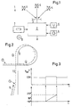
- a system 1 for navigating a vehicle is only included shown a section that deals with the position determination deals.
- a processing device 2 is connected to an antenna 3, the signals from navigation satellites 4 receives. With the help of satellites the positions and directions are spaced from one second, i.e. determined with a frequency of 1 Hz. You can see the distance over the duration of signals to calculate the satellite 4. If the distance is known to at least three satellites, then you can calculate the position of the vehicle on earth. However, this position is with certain Buggy.
- the processing device 2 is also connected to a schematically represented gyroscope 5, the Output signal shown in Fig. 3 (upper graph) is. Finally there is a tachometer 6 with the processing device connected to that of the processing device 2 reports the distance traveled.
- the processing device 2 is also with a schematically illustrated database 7 connected also formed by a reader for a data carrier 8 can be, for example, a CD-ROM. On the database 7 streets can be filed so that they from the processing device 2, for example one Computers that can be recycled.
- the processing facility 2 can be the current position, for example of the vehicle on the road on which the Vehicle is currently located. This procedure will also known as "map matching".
- database 7 is used for route planning, but in this case is of minor interest.
- the system uses for location or position determination of the vehicle to a significant extent so-called “dead reckoning” referred to as. From a known location the distance from the vehicle in which direction travels. The distance is with Using the tachometer 6 determines the direction with Help of the gyroscope 5. By vectorial addition of the individual directed routes can be the current Determine the position of the vehicle.
- the gyroscope 5 then gives when the vehicle is straight drives, a constant voltage of 2.5 V, for example from.
- This constant output voltage of the gyroscope 5 is also called “drift”.
- sensitivity normalizes the deviation of the output signal to an angular velocity. If you integrate this deviation over time, how this is shown in Fig. 3 below, then you get an indication of the angle traveled.
- FIG. 2 shows an example of the course of a street 9. Such a course of the road results, for example at a motorway junction where there is a northbound Want to turn the vehicle west. It will assume that the vehicle is on street 9.
- a course 10 is drawn in with dashed lines Processing device 2 calculated by coupling navigation Has. Due to some inaccuracies and errors, that resulted from this calculation, the course 10 does not exactly match the street 9. In particular, one can see in a section 11 that the direction of the course 10 is not with the direction of street 9 coincides.
- the 270 ° rotation begins at time 3 ⁇ and ends at time 4 ⁇ .
- the Output voltage increases from 2.5 V to 2.6 V.
- the integrated output signal is plotted underneath which should display 270 ° accordingly.
- ⁇ which is, for example, 1,000 °.
- ⁇ which is, for example, 1,000 °.
- the driven Curve include an angle of 60 ° or more. Between the first time 1 ⁇ and the second time 2 ⁇ The mean angular velocity must not be less than a predetermined value. If this Value for example 1 ° / sec. the entire change of direction be at least 60 ° if the time difference 60 sec is.
Abstract
Description
Die Erfindung betrifft ein Verfahren zum Navigieren eines Fahrzeugs, bei dem eine Richtungsänderung des Fahrzeugs durch Integration eines eine Richtungsänderungsgeschwindigkeit anzeigenden Signals ermittelt wird.The invention relates to a method for navigating a Vehicle in which a change of direction of the vehicle by integrating a direction change speed indicating signal is determined.
Ein derartiges Verfahren wird beispielsweise bei einem "Carin" -Navigationssystem verwendet.Such a method is used, for example, for a "Carin" navigation system used.
Der Bedarf an Navigationshilfen ist in den letzten Jahren kontinuierlich gestiegen. Hierbei möchte man dem Fahrer eines Kraftfahrzeugs eine möglichst günstige Route aufzeigen können, auf der er von einem Ausgangsort zum Zielort gelangen kann. Die Gesamtaufgabe gliedert sich hierbei in drei Teile, nämlich die Positionsbestimmung des Fahrzeugs, die Routenplanung und die Übermittlung der Route an den Fahrer. Die vorliegende Erfindung betrifft den ersten Abschnitt, nämlich die Positionsbestimmung des Fahrzeugs. The need for navigation aids has increased in recent years continuously increased. Here you want to Driver of a motor vehicle as cheap as possible Route can point out from a starting point can get to the destination. The overall task is structured here in three parts, namely the position determination of the vehicle, the route planning and the transmission the route to the driver. The present Invention relates to the first section, namely the Positioning of the vehicle.
Für die Positionsbestimmung des Fahrzeuges stehen seit einiger Zeit Navigationssatelliten zur Verfügung, die einen Teil eines "Global Positioning System" oder GPS bilden. Mit Hilfe der Satelliten ist zwar eine Standort- oder Positionsbestimmung mit wenigen Einschränkungen überall möglich. Die hierbei erzielbare Genauigkeit liegt jedoch nur im Bereich von 100 m. Dies mag bei Überlandfahrten in den meisten Fällen ausreichen. Kritisch ist diese "Ungenauigkeit" aber dort, wo der Abstand von Straßen kleiner als diese Größe ist, beispielsweise in Städten oder an Verkehrsknotenpunkten, wo mehrere Straßen in einem relativ dichten Abstand aufeinander treffen.For the position determination of the vehicle stand since some time navigation satellites are available that part of a "Global Positioning System" or GPS form. With the help of the satellites, a location or position can be determined with few restrictions possible anywhere. The accuracy that can be achieved is however only in the range of 100 m. This may be the case when traveling overland sufficient in most cases. Critical is this "inaccuracy" but where the distance of streets is smaller than this size, for example in cities or at traffic junctions, where several streets at a relatively close distance meet each other.
Man ist daher in bestimmten Bereichen dazu übergegangen, eine "Koppelnavigation" zu verwenden, bei der die Position des Fahrzeugs dadurch bestimmt wird, daß man Richtung und Entfernung von einem Ausgangspunkt aus ermittelt. Die aktuelle Position des Fahrzeugs wird also durch eine Art Vektoraddition ermittelt. Ein derartiges Verfahren wird auch als "dead reckoning" bezeichnet. Allerdings summieren sich bei diesem Verfahren Fehler, die bei jeder Vektorbildung entstehen, auf, so daß man auch hier Gefahr läuft, die Position des Fahrzeugs nicht mit der gewünschten Genauigkeit bestimmen zu können.Therefore, in certain areas, to use "dead reckoning" in which the Position of the vehicle is determined by one Direction and distance determined from a starting point. The current position of the vehicle is therefore determined by a kind of vector addition. Such a thing The process is also known as "dead reckoning". However, errors add up in this process, that arise with every vector formation, so that one here too there is a risk of the position of the vehicle not being able to determine with the desired accuracy.
Für die Richtungsbestimmung werden im bekannten Fall Gyroskope verwendet. Gyroskope erzeugen ein Ausgangssignal, für das sich bei Geradeausfahrt oder Stillstand (keine Richtungsänderung) die Bezeichnung "Drift" eingebürgert hat. Wenn das Fahrzeug eine Richtungsänderung vornimmt, ergibt sich eine Änderung des Ausgangssignals, die von der Winkelgeschwindigkeit ω des Fahrzeugs abhängt. Durch Integration dieses Signals über der Zeit kann man dann die Änderung der Richtung ermitteln.For the determination of the direction in the known case Gyroscopes used. Gyroscopes generate an output signal, for when driving straight ahead or at a standstill (no change of direction) naturalized the term "drift" Has. When the vehicle changes direction changes the output signal, that of the angular velocity ω of the vehicle depends. By integrating this signal over time you can then determine the change in direction.
Ein Gyroskop kann beispielsweise einen Ausgangsspannungsbereich von 0 bis 5 V haben, wobei in der Neutralstellung, d.h. wenn das Fahrzeug geradeaus fährt oder steht, eine Ausgangsspannung (Drift) von 2,5 V abgegeben wird. Die Änderung des Ausgangssignals bezogen auf die Winkelgeschwindigkeit, d.h. mV/(°/s), wird als Empfindlichkeit (sensitivity) bezeichnet.For example, a gyroscope can have an output voltage range from 0 to 5 V, in the neutral position, i.e. when the vehicle is driving straight or an output voltage (drift) of 2.5 V is output becomes. The change in output signal related to the angular velocity, i.e. mV / (° / s), is called sensitivity (sensitivity).
Man hat bisher für die Empfindlichkeit einen festen Wert angenommen, beispielsweise 25 mV für 1°/sec. Diese Annahme war zwar vielfach richtig. Man kann aber beobachten, daß die Empfindlichkeit einer relativ großen Streuung bei verschiedenen Gyroskopen unterliegt und auch von der Neigung des Gyroskopen aufgrund der Einbaulage abhängig ist. Die Streubreite kann hierbei über 10 % betragen.So far, one has a fixed sensitivity Accepted value, for example 25 mV for 1 ° / sec. This Assumption was often correct. But you can see that the sensitivity of a relatively large Scattering is subject to different gyroscopes and also from the inclination of the gyroscope due to the installation position is dependent. The spread can be over Amount to 10%.
Man kann sich leicht vorstellen, daß die Richtungsermittlung dann relativ ungenau wird, wenn das Fahrzeug auf der Auffahrrampe eines Parkhauses mehrere Kreise gefahren ist, d.h. Drehungen um ein Vielfaches von 360° ausgeführt hat. Hier kann leicht ein Richtungsfehler von 90° zustande kommen.One can easily imagine that the direction determination then becomes relatively inaccurate when the vehicle Several circles on the ramp of a parking garage has driven, i.e. Rotations by a multiple of 360 ° executed. A directional error can easily occur here from 90 °.
Der Erfindung liegt die Aufgabe zugrunde, Richtungen genauer bestimmen zu können.The invention has for its object directions to be able to determine more precisely.
Diese Aufgabe wird bei einem Verfahren der eingangs genannten
Art dadurch gelöst, daß das Ergebnis der Integration
durch folgende Schritte korrigiert wird:
Die Schritte a-c müssen hierbei nicht bei jeder Richtungsänderung durchgeführt werden. Unter externen Hilfsmitteln sollen solche verstanden werden, die keinen Einfluß auf das Gyroskop bzw. auf eine vergleichbare Einheit haben und von dem Gyroskop nicht beeinflußt werden. Die Differenz zwischen den beiden absoluten Richtungen läßt sich relativ genau bestimmen. Wenn die Empfindlichkeit stimmt, müßte das Ergebnis der Integration dieser Richtungsdifferenz entsprechen. Falls das nicht der Fall ist, kann man eine Korrekturgröße beispielsweise dadurch bilden, daß man die bislang verwendete Korrekturgröße multipliziert mit dem Quotienten aus der Differenz der absoluten Richtungen und dem Integrationsergebnis. Eine derartige Kalibrierung kann während der Fahrt vorgenommen werden, weil das Fahrzeug hier öfters eine Richtungsänderung durchmacht. Damit lassen sich auch Einflußfaktoren berücksichtigen, die die Empfindlichkeit während der Fahrt verändern. Die Kalibrierung läßt sich mit relativ wenigen zusätzlichen Schritten durchführen, wodurch der Verarbeitungsaufwand für das Navigationssystem klein bleibt. Zusätzlich erhält man den Vorteil, daß durch diese Kalibrierung auch der Einfluß der Einbaulage des Gyroskopen auf sein Ausgangssignal berücksichtigt werden kann.Steps a-c do not have to be done with every change of direction be performed. Under external Aids should be understood to mean those that do not Influence on the gyroscope or on a comparable one Have unity and are not affected by the gyroscope become. The difference between the two absolute Directions can be determined relatively precisely. If the Sensitivity is right, the result of the integration should correspond to this difference in direction. If that is not the case, you can use a correction quantity for example form by using the previously used Correction quantity multiplied by the quotient from the difference of the absolute directions and the integration result. Such a calibration can be made while driving because the vehicle undergoes a change of direction here often. In order to influencing factors can also be taken into account change the sensitivity while driving. The Calibration can be done with relatively few additional ones Perform steps, reducing the processing overhead remains small for the navigation system. Additionally receives one has the advantage that this calibration also the influence of the installation position of the gyroscope on its output signal can be taken into account.
Vorzugsweise werden als externe Hilfsmittel Satelliten verwendet. Die Positionsbestimmung mit Hilfe von Satelliten ist zwar relativ ungenau, wie oben angegeben. Die Richtungsbestimmung mit Hilfe von Satelliten ist jedoch wesentlich genauer. Man wertet das Signal der Navigationssatelliten üblicherweise im Abstand von einer Sekunde aus, also mit einer Frequenz von 1 Hz. Man kann also davon ausgehen, daß sich in diesem kurzen Zeitraum der systematische Positionsbestimmungsfehler nicht wesentlich geändert hat, so daß man bei einer Differenzbildung zwischen zwei Positionen den Fehler eliminiert. Man kann die Richtung gegenüber den Satelliten auch relativ einfach über den Doppler-Effekt bestimmen.Preferably external satellites are used used. Positioning with the help of satellites is relatively inaccurate, as stated above. The Direction determination with the help of satellites is however much more accurate. The signal from the navigation satellites is evaluated usually every second off, i.e. with a frequency of 1 Hz. So you can assume that in this short period of time systematic positioning errors not significant has changed, so that when making a difference between two positions eliminates the error. One can also relative the direction towards the satellites simply determine via the Doppler effect.
Alternativ oder zusätzlich dazu können als externe Hilfsmittel Straßen verwendet werden, auf die das Fahrzeug abgebildet wird. Diese Vorgehensweise, d.h. die Abbildung, ist auch als "map matching" bekannt. Man geht hierbei von der Annahme aus, daß sich ein Fahrzeug mit einer relativ großen Wahrscheinlichkeit auf einer Straße bewegen wird, die sich in der Nähe von Positionen befindet, die beispielsweise durch die Koppelnavigation oder mit Hilfe von Satelliten ermittelt worden ist. Diese Vorgehensweise liefert in vielen Fällen zumindest für die Richtungsbestimmung ausreichend genaue Angaben, weil die Richtung der Straße festliegt.Alternatively or in addition, you can use it as an external Aids are used to drive the vehicle is mapped. This approach, i.e. the Illustration, also known as "map matching". Man assumes that there is a vehicle with a relatively high probability on one Road will move that is close to positions located, for example, through the dead reckoning or with the help of satellites is. In many cases, this procedure at least provides sufficiently precise for the direction determination Information because the direction of the street is fixed.
Vorzugsweise sind die Straßen in einer Datenbank abgelegt. Dies erleichtert die Auswertung mit Hilfe eines Computers, der ohnehin für die Auswertung der sonstigen bei der Navigation anfallenden Daten benötigt wird. The streets are preferably stored in a database. This facilitates the evaluation with the help of a Computers, which anyway for the evaluation of the other data required for navigation is required.
Mit Vorteil wird die Korrekturgröße nur dann ermittelt, wenn die Differenz der absoluten Richtungen mindestens 60° beträgt. In diesem Fall ist das Ergebnis der Integration groß genug, so daß hier beispielsweise ein Diskretisierungsfehler keine größere Rolle mehr spielt. Richtungsänderungen mit einer Differenz von mindestens 60° treten beispielsweise dann auf, wenn das Fahrzeug rechtwinklig abbiegt. Größere Richtungsänderungen ergeben sich beispielsweise dann, wenn das Fahrzeug an einem Autobahnkreuz nach links abbiegen will. Da eine Überquerung der Gegenfahrbahn ausgeschlossen ist, muß das Fahrzeug hier üblicherweise eine Richtungsänderung um 270° ausführen.The correction variable is advantageously only determined if if the difference in absolute directions is at least Is 60 °. In this case, the result of the integration large enough so that here, for example, a discretization error no longer plays a major role. Changes in direction with a difference of at least 60 ° occur, for example, when the vehicle turns at right angles. Larger changes in direction result For example, when the vehicle is on a Highway intersection wants to turn left. Because a crossing the oncoming lane is excluded the vehicle usually changes direction here Execute by 270 °.
Bevorzugterweise wird die Korrekturgröße nur dann ermittelt, wenn in dem Zeitraum zwischen dem ersten Zeitpunkt und dem zweiten Zeitpunkt eine vorbestimmte mittlere Winkelgeschwindigkeit nicht unterschritten wird. Beispielsweise wird die Kalibrierung ausgesetzt, wenn die mittlere Winkelgeschwindigkeit kleiner als 1°/sek. ist. In diesem Fall verringert man das Risiko, daß sich Drift-Abweichungen negativ auf die Ermittlung der Korrekturgröße auswirken.The correction variable is preferably only determined when if in the period between the first time and the second time a predetermined average Angular velocity is not fallen below. For example, the calibration is suspended if the mean angular velocity is less than 1 ° / sec. is. In this case you reduce the risk that Drift deviations negatively affect the determination of the correction quantity impact.
Vorzugsweise wird die Korrekturgröße gefiltert. Der Einfluß einer aktuellen Korrekturgrößenermittlung wird dann immer in einen größeren Zusammenhang gestellt, so daß sich beispielsweise "Ausreißer" nicht allzu negativ auswirken. Bei einer derartigen Filterung kann man auch dafür sorgen, daß Korrekturgrößen, die nach einer großen Richtungsänderung ermittelt werden, ein größeres Gewicht bekommen, als Korrekturgrößen, die nach einer kleinen Richtungsänderung ermittelt werden. The correction variable is preferably filtered. The Influence of a current correction quantity determination then always put in a larger context, like this that, for example, "outliers" are not too negative impact. With such a filtering one can also ensure that correction values that follow a large Change of direction can be determined, a larger one Get weight as corrective measures after a small change in direction can be determined.
Die Erfindung wird im folgenden anhand eines bevorzugten Ausführungsbeispiels in Verbindung mit der Zeichnung näher beschrieben. Hierin zeigen:
- Fig. 1
- eine schematische Darstellung eines Navigationssystems,
- Fig. 2
- eine beispielhafte Fahrtstrecke zur Erläuterung der Vorgehensweise und
- Fig. 3
- einige Signalverläufe.
- Fig. 1
- a schematic representation of a navigation system,
- Fig. 2
- an exemplary route to explain the procedure and
- Fig. 3
- some waveforms.
Ein System 1 zum Navigieren eines Fahrzeugs ist nur mit
einem Ausschnitt dargestellt, der sich mit der Positionsbestimmung
befaßt. Eine Verarbeitungseinrichtung 2
ist mit einer Antenne 3 verbunden, die Signale von Navigationssatelliten
4 empfängt. Mit Hilfe von Satelliten
werden die Positionen und Richtungen im Abstand von
einer Sekunde, also mit einer Frequenz von 1 Hz ermittelt.
Über die Laufzeit von Signalen kann man die Entfernung
zu den Satelliten 4 errechnen. Wenn die Entfernung
zu mindestens drei Satelliten bekannt ist, dann
kann man die Position des Fahrzeugs auf der Erde errechnen.
Diese Position ist allerdings mit gewissen
Fehlern behaftet.A
Ferner ist die Verarbeitungseinrichtung 2 verbunden mit
einem schematisch dargestellten Gyroskopen 5, dessen
Ausgangssignal in Fig. 3 (oberer Graph) dargestellt
ist. Schließlich ist noch ein Tachometer 6 mit der Verarbeitungseinrichtung
verbunden, der der Verarbeitungseinrichtung
2 die zurückgelegte Wegstrecke mitteilt. The
Die Verarbeitungseinrichtung 2 ist mit einer ebenfalls
schematisch dargestellten Datenbank 7 verbunden, die
auch durch ein Lesegerät für einen Datenträger 8 gebildet
sein kann, beispielsweise eine CD-ROM. Auf der Datenbank
7 können Straßen so abgelegt sein, daß sie von
der Verarbeitungseinrichtung 2, beispielsweise einem
Computer, verwertet werden können. Die Verarbeitungseinrichtung
2 kann beispielsweise die aktuelle Position
des Fahrzeugs auf der Straße abbilden, auf der sich das
Fahrzeug gerade befindet. Diese Vorgehensweise wird
auch als "map matching" bezeichnet. Darüber hinaus
dient die Datenbank 7 zur Routenplanung, die aber im
vorliegenden Fall von untergeordnetem Interesse ist.The
Das System verwendet zur Standort- oder Positionsbestimmung
des Fahrzeugs zu einem wesentlichen Teil eine
sogenannte "Koppelnavigation", die auch als "dead reckoning"
bezeichnet wird. Von einem bekannten Standort
aus wird ermittelt, welche Entfernung das Fahrzeug in
welche Richtung zurücklegt. Die Entfernung wird mit
Hilfe des Tachometers 6 ermittelt, die Richtung mit
Hilfe des Gyroskopen 5. Durch eine vektorielle Addition
der einzelnen gerichteten Strecken läßt sich die aktuelle
Position des Fahrzeugs bestimmen.The system uses for location or position determination
of the vehicle to a significant extent
so-called "dead reckoning"
referred to as. From a known location
the distance from the vehicle in
which direction travels. The distance is with
Using the tachometer 6 determines the direction with
Help of the
Das Gyroskop 5 gibt dann, wenn das Fahrzeug geradeaus
fährt, eine konstante Spannung von beispielsweise 2,5 V
ab. Diese konstante Ausgangsspannung des Gyroskopen 5
wird auch als "Drift" bezeichnet.The
Wenn sich die Richtung des Fahrzeugs ändert, ändert
sich auch die Ausgangsspannung des Gyroskopen 5. Die
Abweichung des Ausgangssignals von seinem "Ruhewert"
ist abhängig von der Geschwindigkeit, mit der das Fahrzeug
die Richtung ändert. Diese Winkelgeschwindigkeitsabhängigkeit
wird als Empfindlichkeit bezeichnet. Die
Empfindlichkeit normiert besser gesagt die Abweichung
des Ausgangssignals auf eine Winkelgeschwindigkeit.
Wenn man diese Abweichung über der Zeit integriert, wie
dies in Fig. 3 unten dargestellt ist, dann erhält man
eine Angabe über den zurückgelegten Winkel.When the direction of the vehicle changes, changes
the output voltage of the
Fig. 2 zeigt beispielhaft den Verlauf einer Straße 9. Ein derartiger Straßenverlauf ergibt sich beispielsweise bei einem Autobahnkreuz, an dem ein nach Norden fahrendes Fahrzeug nach Westen abbiegen möchte. Es wird angenommen, daß sich das Fahrzeug auf der Straße 9 befindet.2 shows an example of the course of a street 9. Such a course of the road results, for example at a motorway junction where there is a northbound Want to turn the vehicle west. It will assume that the vehicle is on street 9.
Gestrichelt eingezeichnet ist ein Verlauf 10, den die
Verarbeitungseinrichtung 2 durch Koppelnavigation errechnet
hat. Aufgrund einiger Ungenauigkeiten und Fehler,
die sich bei dieser Berechnung ergeben haben,
stimmt der Verlauf 10 nicht genau mit der Straße 9 überein.
Insbesondere kann man in einem Abschnitt 11 erkennen,
daß auch die Richtung des Verlaufs 10 nicht mit
der Richtung der Straße 9 übereinstimmt.A course 10 is drawn in with dashed
Zu einem Zeitpunkt 1 ○ wird nun mit Hilfe der Satelliten
4 die Richtung des Fahrzeuges bestimmt. Dieser Wert
wird als absolute Richtung angenommen. Die Koppelnavigation
der Verarbeitungseinrichtung 2 nimmt diesen Wert
nun als neue Richtung an. Das Fahrzeug durchläuft nun
eine Kurve von 270°. Zu einem Zeitpunkt 2 ○ wird wiederum
eine Richtungsbestimmung mit Hilfe der Satelliten 4
vorgenommen. Die Koppelnavigation in der Verarbeitungseinrichtung
wird wieder auf diesen neuen Richtungswert
gesetzt. At a
Die Drehung um 270° beginnt am Zeitpunkt 3 ○ und endet
am Zeitpunkt 4 ○. Wie aus Fig. 3 zu erkennen ist, ändert
sich zwischen dem ersten Zeitpunkt 3 ○ und dem zweiten
Zeitpunkt 4 ○ die Ausgangsspannung des Gyroskopen 5. Die
Ausgangsspannung steigt nämlich von 2,5 V auf 2,6 V.
Darunter ist das integrierte Ausgangssignal aufgetragen,
das dementsprechend 270° anzeigen soll.The 270 ° rotation begins at
Zu den Zeitpunkten 1 ○ und 2 ○ wurde die absolute Richtung
bestimmt und zwar mit Mitteln, die weder durch das Gyroskop
5 beeinflußt werden noch dieses beeinflussen.
Wenn der Skalierungsfaktor S des Gyroskops 5 stimmt,
dann wird sich nach der Integration ebenfalls ein Ausgangswert
von 270° für das gewählte Beispiel ergeben.At
Man kann nun einen neuen Skalierungsfaktor Sneu aus dem
bisher verwendeten Skalierungsfaktor Salt, dem aus der
Differenz der absoluten Richtung ermittelten Wert A und
der sich aus dem Integrationsergebnis I ergebenden
Richtungsdifferenz dadurch ermitteln, daß man bildet
Man kann nun den Wert Sneu auch noch filtern, in dem man
beispielsweise folgende Filterfunktion verwendet
Hierbei wird für ϕ ein mehr oder weniger frei wählbarer Referenzwinkel vorgegeben, der beispielsweise 1.000° beträgt. Auf diese Weise kann man die Größe der Richtungsänderung noch in die Gewichtung einfließen lassen, d.h. wenn die gefahrene Kurve größer ist, hat auch Sneu ein größeres Gewicht auf SFilter.Here, a more or less freely selectable reference angle is specified for ϕ, which is, for example, 1,000 °. In this way, the magnitude of the change in direction can still be included in the weighting, ie if the driven curve is larger, S new also has a greater weight on S filters .
Man kann nun noch verschiedene Bedingungen vorsehen,
die erfüllt sein müssen, damit der Skalierungsfaktor S,
den man auch als Korrekturgröße bezeichnen kann, überhaupt
ermittelt werden kann. Beispielsweise muß die gefahrene
Kurve einen Winkel von 60° oder mehr umfassen.
Zwischen dem ersten Zeitpunkt 1 ○ und dem zweiten Zeitpunkt
2 ○ darf die mittlere Winkelgeschwindigkeit nicht
kleiner als ein vorbestimmter Wert sein. Wenn dieser
Wert beispielsweise 1°/sek. ist, muß die gesamte Richtungsänderung
mindestens 60° betragen, wenn die Zeitdifferenz
60 sek. beträgt.You can now provide different conditions
that have to be fulfilled so that the scaling factor S,
which can also be called a correction quantity, at all
can be determined. For example, the driven
Curve include an angle of 60 ° or more.
Between the
Claims (7)
Applications Claiming Priority (2)
| Application Number | Priority Date | Filing Date | Title |
|---|---|---|---|
| DE19945120 | 1999-09-21 | ||
| DE19945120A DE19945120C2 (en) | 1999-09-21 | 1999-09-21 | Method of navigating a vehicle |
Publications (3)
| Publication Number | Publication Date |
|---|---|
| EP1087208A2 true EP1087208A2 (en) | 2001-03-28 |
| EP1087208A3 EP1087208A3 (en) | 2004-01-21 |
| EP1087208B1 EP1087208B1 (en) | 2007-02-28 |
Family
ID=7922709
Family Applications (1)
| Application Number | Title | Priority Date | Filing Date |
|---|---|---|---|
| EP00118041A Expired - Lifetime EP1087208B1 (en) | 1999-09-21 | 2000-08-23 | Vehicle navigation method |
Country Status (3)
| Country | Link |
|---|---|
| US (1) | US6366850B1 (en) |
| EP (1) | EP1087208B1 (en) |
| DE (2) | DE19945120C2 (en) |
Citations (8)
| Publication number | Priority date | Publication date | Assignee | Title |
|---|---|---|---|---|
| JPS59104510A (en) * | 1982-12-06 | 1984-06-16 | Mitsubishi Electric Corp | On-vehicle bearing sensor |
| US4743913A (en) * | 1986-02-19 | 1988-05-10 | Nissan Motor Company, Limited | Hybrid navigation system for determining a relative position and direction of a vehicle and method therefor |
| GB2216272A (en) * | 1988-02-29 | 1989-10-04 | Nissan Motor | Vehicle's driving azimuth detecting apparatus correcting disturbed geomagnetic azimuth |
| JPH01295312A (en) * | 1988-05-24 | 1989-11-29 | Toshiba Corp | Guiding device for unmanned vehicle |
| EP0373317A2 (en) * | 1988-10-14 | 1990-06-20 | Sumitomo Electric Industries, Ltd. | Device and method for determining errors in the data of a magnetic direction sensor |
| EP0496517A1 (en) * | 1991-01-23 | 1992-07-29 | Sumitomo Electric Industries, Ltd. | Method of calculating scale factor of gyro |
| DE4208158A1 (en) * | 1991-03-13 | 1992-09-17 | Tokimec Inc | CIRCUIT SYSTEM |
| EP0844462A2 (en) * | 1996-11-22 | 1998-05-27 | Zexel Corporation | Method and apparatus for determining the position of a moving object |
Family Cites Families (7)
| Publication number | Priority date | Publication date | Assignee | Title |
|---|---|---|---|---|
| JP2946051B2 (en) * | 1990-02-22 | 1999-09-06 | 株式会社トキメック | Gyro device |
| JP2946050B2 (en) * | 1990-02-22 | 1999-09-06 | 株式会社トキメック | Gyro device |
| US5345382A (en) * | 1992-05-15 | 1994-09-06 | Zexel Corporation | Calibration method for a relative heading sensor |
| US5572217A (en) * | 1993-06-04 | 1996-11-05 | Flawn; Brian J. | Compass |
| US5928309A (en) * | 1996-02-05 | 1999-07-27 | Korver; Kelvin | Navigation/guidance system for a land-based vehicle |
| EP0810570B1 (en) * | 1996-05-31 | 2003-10-15 | Xanavi Informatics Corporation | Navigation system indicating distance to traffic jams |
| US5877723A (en) * | 1997-03-05 | 1999-03-02 | Caterpillar Inc. | System and method for determining an operating point |
-
1999
- 1999-09-21 DE DE19945120A patent/DE19945120C2/en not_active Expired - Fee Related
-
2000
- 2000-08-23 EP EP00118041A patent/EP1087208B1/en not_active Expired - Lifetime
- 2000-08-23 DE DE50014109T patent/DE50014109D1/en not_active Expired - Fee Related
- 2000-09-07 US US09/657,077 patent/US6366850B1/en not_active Expired - Fee Related
Patent Citations (8)
| Publication number | Priority date | Publication date | Assignee | Title |
|---|---|---|---|---|
| JPS59104510A (en) * | 1982-12-06 | 1984-06-16 | Mitsubishi Electric Corp | On-vehicle bearing sensor |
| US4743913A (en) * | 1986-02-19 | 1988-05-10 | Nissan Motor Company, Limited | Hybrid navigation system for determining a relative position and direction of a vehicle and method therefor |
| GB2216272A (en) * | 1988-02-29 | 1989-10-04 | Nissan Motor | Vehicle's driving azimuth detecting apparatus correcting disturbed geomagnetic azimuth |
| JPH01295312A (en) * | 1988-05-24 | 1989-11-29 | Toshiba Corp | Guiding device for unmanned vehicle |
| EP0373317A2 (en) * | 1988-10-14 | 1990-06-20 | Sumitomo Electric Industries, Ltd. | Device and method for determining errors in the data of a magnetic direction sensor |
| EP0496517A1 (en) * | 1991-01-23 | 1992-07-29 | Sumitomo Electric Industries, Ltd. | Method of calculating scale factor of gyro |
| DE4208158A1 (en) * | 1991-03-13 | 1992-09-17 | Tokimec Inc | CIRCUIT SYSTEM |
| EP0844462A2 (en) * | 1996-11-22 | 1998-05-27 | Zexel Corporation | Method and apparatus for determining the position of a moving object |
Non-Patent Citations (1)
| Title |
|---|
| PATENT ABSTRACTS OF JAPAN vol. 008, no. 219 (P-306), 5. Oktober 1984 (1984-10-05) & JP 59 104510 A (MITSUBISHI DENKI KK), 16. Juni 1984 (1984-06-16) * |
Also Published As
| Publication number | Publication date |
|---|---|
| DE19945120C2 (en) | 2001-12-06 |
| US6366850B1 (en) | 2002-04-02 |
| EP1087208B1 (en) | 2007-02-28 |
| DE19945120A1 (en) | 2001-04-12 |
| EP1087208A3 (en) | 2004-01-21 |
| DE50014109D1 (en) | 2007-04-12 |
Similar Documents
| Publication | Publication Date | Title |
|---|---|---|
| DE69728501T2 (en) | Car navigation system | |
| DE69826340T2 (en) | Method and device for determining an alternative route in a vehicle navigation system | |
| DE10050765B4 (en) | Route setting method and associated navigation device | |
| DE19735946A1 (en) | Vehicle navigation system for setting direction indications for connecting streets | |
| DE60027879T2 (en) | Route guidance device | |
| DE10022528A1 (en) | Vehicle navigation computer having curve smoothing procedure for more accurate representation of journey curves taken from course map data stored on CD-ROM | |
| DE102009001553A1 (en) | Driver assistance system, driver assistance procedure and computer program | |
| DE10307591A1 (en) | Navigation device and navigation method | |
| DE102016213817B4 (en) | A method, apparatus and computer readable storage medium having instructions for determining the lateral position of a vehicle relative to the lanes of a lane | |
| EP0730726A1 (en) | Process for producing a digitised road map | |
| DE19519066A1 (en) | Method and system for guiding a vehicle | |
| DE102006027832A1 (en) | Car navigation system | |
| DE19926367A1 (en) | Navigation device and method for controlling the scale of a map section shown on a display unit of a navigation device | |
| DE102009022881A1 (en) | Method and navigation device for geographical position determination | |
| EP1380021B1 (en) | Method for operating a navigation system for a vehicle | |
| DE10319445A1 (en) | Driver assistance device with course prediction module | |
| EP1301755B1 (en) | Navigation device and position correction method | |
| DE19753172A1 (en) | Process for computer-aided navigation of a vehicle with a terminal, terminal and traffic center | |
| WO1998013666A1 (en) | Navigation-assistance method and device for a vehicle driver | |
| EP1006340B1 (en) | Method for determining the position of a vehicle | |
| DE102008042732A1 (en) | Method for determining a route and device therefor | |
| DE19945121C2 (en) | Method of navigating a vehicle | |
| EP1087208A2 (en) | Vehicle navigation method | |
| DE102020105313A1 (en) | Method, computing device and system for mapping landmarks of a road network in a road map | |
| DE102009042470A1 (en) | Arrangement for collecting toll charge of lorry on highway roads, has edge lines for arrangement of position of vehicle to tracks by traffic lane, where toll charges are detected and stored according to different toll lanes |
Legal Events
| Date | Code | Title | Description |
|---|---|---|---|
| PUAI | Public reference made under article 153(3) epc to a published international application that has entered the european phase |
Free format text: ORIGINAL CODE: 0009012 |
|
| AK | Designated contracting states |
Kind code of ref document: A2 Designated state(s): AT BE CH CY DE DK ES FI FR GB GR IE IT LI LU MC NL PT SE |
|
| AX | Request for extension of the european patent |
Free format text: AL;LT;LV;MK;RO;SI |
|
| RAP1 | Party data changed (applicant data changed or rights of an application transferred) |
Owner name: SIEMENS AKTIENGESELLSCHAFT |
|
| PUAL | Search report despatched |
Free format text: ORIGINAL CODE: 0009013 |
|
| AK | Designated contracting states |
Kind code of ref document: A3 Designated state(s): AT BE CH CY DE DK ES FI FR GB GR IE IT LI LU MC NL PT SE |
|
| AX | Request for extension of the european patent |
Extension state: AL LT LV MK RO SI |
|
| RIC1 | Information provided on ipc code assigned before grant |
Ipc: 7G 01C 21/16 B Ipc: 7G 01S 5/14 B Ipc: 7G 01C 17/38 B Ipc: 7G 01C 21/28 A |
|
| 17P | Request for examination filed |
Effective date: 20040216 |
|
| AKX | Designation fees paid |
Designated state(s): DE FR GB |
|
| 17Q | First examination report despatched |
Effective date: 20060630 |
|
| GRAP | Despatch of communication of intention to grant a patent |
Free format text: ORIGINAL CODE: EPIDOSNIGR1 |
|
| GRAS | Grant fee paid |
Free format text: ORIGINAL CODE: EPIDOSNIGR3 |
|
| GRAA | (expected) grant |
Free format text: ORIGINAL CODE: 0009210 |
|
| AK | Designated contracting states |
Kind code of ref document: B1 Designated state(s): DE FR GB |
|
| REG | Reference to a national code |
Ref country code: GB Ref legal event code: FG4D Free format text: NOT ENGLISH |
|
| REF | Corresponds to: |
Ref document number: 50014109 Country of ref document: DE Date of ref document: 20070412 Kind code of ref document: P |
|
| GBT | Gb: translation of ep patent filed (gb section 77(6)(a)/1977) |
Effective date: 20070523 |
|
| ET | Fr: translation filed | ||
| PLBE | No opposition filed within time limit |
Free format text: ORIGINAL CODE: 0009261 |
|
| STAA | Information on the status of an ep patent application or granted ep patent |
Free format text: STATUS: NO OPPOSITION FILED WITHIN TIME LIMIT |
|
| 26N | No opposition filed |
Effective date: 20071129 |
|
| PGFP | Annual fee paid to national office [announced via postgrant information from national office to epo] |
Ref country code: DE Payment date: 20080822 Year of fee payment: 9 |
|
| PGFP | Annual fee paid to national office [announced via postgrant information from national office to epo] |
Ref country code: FR Payment date: 20080813 Year of fee payment: 9 |
|
| PGFP | Annual fee paid to national office [announced via postgrant information from national office to epo] |
Ref country code: GB Payment date: 20080821 Year of fee payment: 9 |
|
| GBPC | Gb: european patent ceased through non-payment of renewal fee |
Effective date: 20090823 |
|
| REG | Reference to a national code |
Ref country code: FR Ref legal event code: ST Effective date: 20100430 |
|
| PG25 | Lapsed in a contracting state [announced via postgrant information from national office to epo] |
Ref country code: DE Free format text: LAPSE BECAUSE OF NON-PAYMENT OF DUE FEES Effective date: 20100302 Ref country code: FR Free format text: LAPSE BECAUSE OF NON-PAYMENT OF DUE FEES Effective date: 20090831 |
|
| PG25 | Lapsed in a contracting state [announced via postgrant information from national office to epo] |
Ref country code: GB Free format text: LAPSE BECAUSE OF NON-PAYMENT OF DUE FEES Effective date: 20090823 |