EP1378764A1 - Object detection system and method of estimating object size - Google Patents
Object detection system and method of estimating object size Download PDFInfo
- Publication number
- EP1378764A1 EP1378764A1 EP03076972A EP03076972A EP1378764A1 EP 1378764 A1 EP1378764 A1 EP 1378764A1 EP 03076972 A EP03076972 A EP 03076972A EP 03076972 A EP03076972 A EP 03076972A EP 1378764 A1 EP1378764 A1 EP 1378764A1
- Authority
- EP
- European Patent Office
- Prior art keywords
- range
- estimating
- detection system
- measurements
- width
- Prior art date
- Legal status (The legal status is an assumption and is not a legal conclusion. Google has not performed a legal analysis and makes no representation as to the accuracy of the status listed.)
- Granted
Links
Images


Classifications
-
- G—PHYSICS
- G01—MEASURING; TESTING
- G01S—RADIO DIRECTION-FINDING; RADIO NAVIGATION; DETERMINING DISTANCE OR VELOCITY BY USE OF RADIO WAVES; LOCATING OR PRESENCE-DETECTING BY USE OF THE REFLECTION OR RERADIATION OF RADIO WAVES; ANALOGOUS ARRANGEMENTS USING OTHER WAVES
- G01S13/00—Systems using the reflection or reradiation of radio waves, e.g. radar systems; Analogous systems using reflection or reradiation of waves whose nature or wavelength is irrelevant or unspecified
- G01S13/02—Systems using reflection of radio waves, e.g. primary radar systems; Analogous systems
- G01S13/50—Systems of measurement based on relative movement of target
- G01S13/505—Systems of measurement based on relative movement of target using Doppler effect for determining closest range to a target or corresponding time, e.g. miss-distance indicator
-
- G—PHYSICS
- G01—MEASURING; TESTING
- G01S—RADIO DIRECTION-FINDING; RADIO NAVIGATION; DETERMINING DISTANCE OR VELOCITY BY USE OF RADIO WAVES; LOCATING OR PRESENCE-DETECTING BY USE OF THE REFLECTION OR RERADIATION OF RADIO WAVES; ANALOGOUS ARRANGEMENTS USING OTHER WAVES
- G01S13/00—Systems using the reflection or reradiation of radio waves, e.g. radar systems; Analogous systems using reflection or reradiation of waves whose nature or wavelength is irrelevant or unspecified
- G01S13/88—Radar or analogous systems specially adapted for specific applications
- G01S13/93—Radar or analogous systems specially adapted for specific applications for anti-collision purposes
- G01S13/931—Radar or analogous systems specially adapted for specific applications for anti-collision purposes of land vehicles
- G01S2013/9327—Sensor installation details
- G01S2013/93271—Sensor installation details in the front of the vehicles
Definitions
- the present invention generally relates to object detection and, more particularly, relates to a vehicle object detection system and method of estimating the size of an object such as length and width dimensions.
- Automotive vehicles are increasingly being equipped with collision avoidance and warning systems for predicting the potential collision with an external object, such as another vehicle or a pedestrian. Upon detecting a potential collision, such systems typically initiate an action to avoid the collision and/or provide a warning to the vehicle operator.
- Adaptive cruise control systems have been proposed to track a leading vehicle and automatically control the speed of the following vehicle.
- the ability to accurately predict an upcoming collision also enables a vehicle controller to control and deploy safety-related devices on the vehicle. For example, upon predicting an anticipated collision or near collision with an object, the vehicle seat belt pretensioner could be activated in a timely manner to pretension the seat belt, thereby enhancing the application of the safety device.
- the controller could also deploy a warning signal to notify the vehicle driver of a predicted collision with an object.
- the host vehicle In conventional target tracking systems employed on automotive vehicles, the host vehicle is generally equipped with a sensor arrangement that acquires range, range rate, and azimuth angle (i.e., direction to target) measurements for each tracked target within a field of view.
- the sensor arrangement employed in many conventional collision detection systems is generally complex and costly and includes a plurality of radar beams or laser beams covering a field of view.
- the conventional collision detection system In order to detect an anticipated vehicle collision with an object, the conventional collision detection system generally senses the presence of an object, tracks the movement of the sensed object, measures the azimuth angle of the object, range to the object, and range rate of the object, all relative to the host vehicle.
- the size of the object in order to determine whether or not to deploy one or more countermeasures and, if so, to further determine what type of countermeasures to deploy. For example, for an anticipated collision with a relatively large object, such as another vehicle or a pedestrian, it may be desirable to deploy certain countermeasures such as pretensioning the seat belt and deploying one or more air bags. However, for relatively small objects, such as a beverage container, no countermeasure deployment may be necessary. Further, it may be desirable to differentiate between certain types of objects, such as a pedestrian and a vehicle so as to deploy different countermeasures depending on the object size and/or type of object.
- the detection system includes a sensor for sensing an object within a field of view.
- the sensor measures range and range rate of the sensed object.
- the detection system further includes a controller for estimating a size dimension of the object as a function of the range and range rate. The controller estimates the size dimension absent an azimuth angle measurement of the object.
- a method of estimating a size dimension of an object includes the steps of sensing the presence of an object, tracking the sensed object, measuring range to the object for each of a plurality of measurements, and determining range rate of the object for each of the plurality of measurements.
- the method also includes the steps of estimating a size dimension of the object as a function of the range and the range rate.
- the size dimension is estimated absent an azimuth angle measurement.
- the detection system and method of estimating a size dimension of an object advantageously estimates a size dimension (e.g., length or width) of an object without requiring a complex and costly sensor arrangement, such as those which determine an azimuth angle measurement of the object.
- an automotive vehicle 10 having a collision detection system including a radar sensor 12 mounted thereto to cover a desired field of view 14 in front of the vehicle 10.
- the vehicle collision detection system senses and tracks one or more objects, such as moving target 16, and estimates a miss distance M for each sensed object.
- the miss distance M is the closest anticipated distance between the target 16 and the vehicle 10.
- the collision detection system is able to detect an anticipated collision between the vehicle 10 and the target 16, thereby allowing for responsive action to be taken.
- the collision detection system further estimates size dimensions of length and width of the object 16 by exploiting differences in range and range rate observed over the span of the distributed object.
- the estimated size dimensions of length and width of the object 16 provide a useful indication of the size of the object which can be useful in determining whether to deploy one or more countermeasures and what type of countermeasure(s) to deploy.
- the estimated length and width could further be useful in combination with information from other sensors, such as a camera to identify the location of an object in an image.
- the sensor 12 may include a single sensor or a plurality of sensors arranged to cover the field of view 14 to sense the presence of one or more objects. The sensor 12 also tracks the relative movement of each sensed object within the field of view 14. Sensor 12 measures the range (radial distance) R to the target object 16, and further measures the range rate (time rate of change of radial distance) of the target object 16.
- the range R is the measured radial distance between the vehicle 10 and the object 16 which is output from sensor 12 and may include sensor noise.
- the range rate is the measured rate of change of the range R of the object 16 as a function of time relative to the host vehicle 10 which may be output from sensor 12 and may also include noise.
- Sensor 12 may be a Doppler radar sensor that determines range rate based on the radar Doppler effect.
- the range rate may be determined by computing the time rate of change (i.e., derivative) of sensed range R.
- Sensor 12 may include a commercially available off-the-shelf wide-beam staring microwave Doppler radar sensor.
- object detecting sensors including other types of radar sensors, video imaging cameras, and laser sensors may be employed to detect the presence of an object, track the relative movement of the detected object, and determine the range and range rate measurements R and that are processed to estimate the miss distance M and length and width of the object 16.
- the collision detection system and method of the present invention advantageously estimates the miss distance M and estimates length and width size dimensions of the object 16 as a function of the range and range rate measurements R and , without the requirement of acquiring an azimuth angle measurement of the object.
- the collision detection system of the present invention is able to use a reduced complexity and less costly sensing arrangement.
- Controller 20 preferably includes a microprocessor-based controller having a microprocessor 22 and memory 24.
- Memory 24 may include random access memory (RAM), read-only memory (ROM), and electrically erasable programmable read-only memory (EEPROM).
- Controller 20 may be a commercially available off-the-shelf controller and may be dedicated to precrash processing or object detection processing, or may share processing capability with other vehicle functions.
- the controller 20 receives the range measurement R and range rate measurement from the radar sensor 12 and processes the received range and range rate measurements R and with a miss distance estimation and collision detection routine to determine the miss distance M of the target object 16 relative to the host vehicle 10.
- the collision detection routine processes the estimated miss distance M to determine whether a potential collision of the object 16 with the vehicle 10 may occur.
- the controller 20 further processes the received range and range rate measurements R and with length and width estimation routines to estimate the size dimensions of length and width of the object as an indication of the size of the object. By providing an indication of the size of the object, the controller 20 may decide whether or not to deploy any countermeasures in response to an anticipated collision based on object size, and may further decide which type of countermeasures to deploy based on object size.
- the controller 20 generates an output signal 26 in the event that an anticipated vehicle collision has been determined.
- the output signal 26 may be supplied as an input to one or more devices in the vehicle, such as a seat belt pretensioner 28, to activate the device(s) in anticipation of an anticipated upcoming collision.
- the seat belt pretensioner 28 may be controlled to pretension the seat belt just prior to the anticipated vehicle collision to eliminate slack in the restraining device.
- the output signal 26 may be provided to one or more warning devices 30 to warn the vehicle operator and occupants of an anticipated vehicle collision. It should further be appreciated that other devices may be deployed as countermeasures including vehicle air bags, pop-up roll bars, and other safety-related devices.
- an object length, width, and miss distance estimator 32 is generally shown receiving the range measurement R and range rate measurement , both generated by sensor 12.
- the range and range rate measurements R and are processed by the estimator 32, which includes a programmed routine as shown in FIG. 4 to estimate the miss distance M, and object size estimation routines as shown in FIGS. 10-12 to estimate length L and width W of the target object 16.
- the miss distance estimator 32 may also estimate speed S of the target object 16.
- miss distance estimation and the object length and width estimations of the present invention assume that the target object 16 is moving straight and at a constant speed relative to the host vehicle 10.
- the target object heading i.e., the direction of speed S on line 17
- the miss angle ⁇ is changing and the range rate is changing.
- the miss angle ⁇ is the angle between a line extending radially from the vehicle 10 to the object 16 and the line 17 in the direction of movement of the object 16. If exact measurements of range R and range rate are available at time instant k and k+1, the speed of the object can be obtained.
- routine 40 for estimating the miss distance M of a target object and determining a collision detection signal 26.
- Routine 40 begins at step 42 and proceeds to step 44 to receive the sensor measurement data, including the range measurement R and range rate measurement , for each object sensed within the sensor field of view.
- routine 40 associates data with the particular target object by way of an object tracker.
- the object tracker tracks each object based on the combination of range and range rate measurements R and . If the current range and range rate measurements R and are sufficiently close in value to the predicted range and range rate values, the object measurements are assumed to pertain to the same object.
- the tracking of each detected object allows for a consistent stream of measurement data at incremental time periods k, k+1, k+2, etc. for each sensed object.
- routine 40 computes a mathematical square of the range R as shown by R 2 , and also computes a mathematical square of the product of range and range rate as shown by (R ⁇ ) 2 for each of X number of most recent measurements for a tracked object.
- the squared range and squared product of range and rate values R 2 and (R ⁇ ) 2 , respectively, for each of X measurements are preferably stored in memory and are processed by controller 20 as explained herein.
- the number X of measurements may include thirty (30), according to one example, or may include fewer or greater number of measurements. Processing of a greater number of measurements may result in less noise, but may be less responsive to maneuvers between the object and the host vehicle. Accordingly, the number X of measurements selected is a compromise and may vary depending on the application.
- routine 40 generates a least-squares fit line (curve) for a window of recent data for the tracked object in a plane, referred to herein as the W-plane.
- the W-plane is defined as a plane having data plotted on X-axis and Y-axis coordinates, such as is shown in FIG. 5.
- the Y-axis coordinate represents the squared range R 2 values
- the X-axis coordinate represents the squared product of range and range rate (R ⁇ ) 2 values.
- the pairs of computed values for each data measurement may be plotted in the W-plane as shown by points 64 for X number of measurements.
- a least-squares fit line 66 is generated based on a close fit to the plurality of plotted measurements 64.
- routine 40 extracts estimates of the miss distance M and speed S of the object from the fitted line 66 shown in the W-plane.
- the curve 66 crosses the vertical axis defined by the squared range R 2 at a point 68 when the squared product of range and range rate (R ⁇ ) 2 is equal to zero.
- the miss distance M is defined as the square root of the squared range R 2 value
- point 68 is the measured point at which the object reaches the closest anticipated point of approach to the host vehicle.
- R 2 is set to a value of zero.
- the miss distance M and speed S may be estimated from an interpretation of the fitted curve 66.
- This relationship is shown in the following equation: wherein 1 / S 2 represents the slope of curve 66 as defined by horizontal segment 70 and vertical segment 72. Accordingly, the speed S of the object relative to the vehicle may be estimated based on the slope of curve 66.
- the miss distance M is the distance that the target object would have come closest to the vehicle 10 if the object continued along the instantaneous curve.
- the points plotted in the W-plane form a straight line with an intercept on the R 2 axis having a value equal to M 2 and with a slope of 1 / S 2 . While a straight line curve 66 is shown, it should be appreciated that some higher-order curve may be employed to define the relationship of the sample points.
- routine 40 calculates the time to closest point-of-approach T CPA for the target object.
- the time to closest point-of-approach T CPA can be calculated based on range, range rate, and a calculated acceleration of the object in the radial direction.
- routine 40 determines if the following two conditions are met: (1) is estimated miss distance M less than threshold 1; and (2) is T CPA less than threshold 2. If both conditions are met in step 56, routine 40 generates an output signal to provide a signal warning or to deploy countermeasures in step 58.
- the countermeasures may include pretensioning a seat belt pretensioner, providing a warning, or initiating other appropriate action.
- the estimated miss distance M may be used to determine if an imminent collision is anticipated or may be employed to determine if a close collision is anticipated.
- T CPA time to closest point-of-approach
- routine 40 ends at step 60.
- miss distance estimation assumes that the target object 16 is moving straight and at a constant speed relative to the host vehicle 10. If variations in speed and/or direction of the object 16 occur relative to the host vehicle 10, the successive instantaneous measurements will account for variations in direction or speed. While the miss distance estimation has been described in connection with a linear curve 66, it should be appreciated that higher-order curves (e.g., parabolas) may be employed. It should further be appreciated that the use of a weighting matrix in the curve fitting process (e.g., based on the inverse of range squared) and accounting for the correlation between errors in the two W-plane quantities in the curve fitting process may also be provided.
- a weighting matrix in the curve fitting process e.g., based on the inverse of range squared
- the collision detection system of the present invention estimates the size of object 16 by estimating the length L and width W of the object moving through the field of view 14 of the radar sensor 12.
- the vehicle collision detection system 18 processes a sequence of range and range rate measurements R and of each target object 16, exploits differences in range and range rate measurements R and monitored over the span of the distributed object 16, and provides running estimates of the length L and width W of the object 16 as described herein.
- the scattering centers for each radar sensor measurement taken are ideally distributed over the span of the object 16, and the collision detection system is tuned to isolate the individual scatterers, rather than lumping such measurements together into one return.
- both the host vehicle 10 and the target object 16 are in uniform motion (moving straight at constant speed).
- the assumption of uniform motion allows for conceptual viewing of the host vehicle 10 as being stationary and focuses on relative velocity of the target object 16 relative to the host vehicle 10. According to this assumption, the host vehicle 10 may be considered stationary, and therefore the target object' s velocity and the object' s velocity relative to the host vehicle are considered the same.
- the length L and width W estimates are obtained by exploiting the differences in range and range rate of the distributed object 16 by analyzing the data in the W-plane.
- a point target in uniform motion relative to the host vehicle 10 traces a straight line in the W-plane with the line intercepting the vertical axis at a point 68 that is equal to the square of the miss distance M, and the line has a slope related to relative speed of the object ( 1 / S 2 ).
- the distance (d) between the target object 16 and a point where the miss distance M occurs is referred to as the distance to closest point-of-approach.
- the vertical and horizontal axes of the W-plane can further be represented in terms of the miss distance M, the distance d between the sensed location on the object and the anticipated closest point-of-approach, and the relative speed S of the target object as shown in FIG. 6.
- the vertical axis may also be represented by M 2 +d 2
- the horizontal axis may also be represented by d 2 S 2 .
- the data shown in the W-plane of FIG. 6 is for a sensed target object having a relatively flat rectangular shape, such as an automotive vehicle, moving with a relative velocity that is parallel to the longitudinal axis of the target object (vehicle).
- the radar sensor signal returns from various locations on the object form a parallelogram pattern 80 in the W-plane.
- the pattern 80 moves in the W-plane as the object 16 moves relative to the host vehicle 10.
- the front edge of the object 16 defined by the near front (NF) corner and the far front (FF) corner has a constant distance d to closest point-of-approach and, because speed S is assumed to be constant, the corresponding points plotted in the W-plane have the same horizontal axis value.
- the points on the front edge of the object have differing miss distance M values, however, so the front edge of the object maps into a vertical line segment 86 in the W-plane.
- the rear edge of the object 16 defined by the near rear (NR) corner and the far rear (FR) corner maps into a vertical line segment 88 in the W-plane.
- the points on the near side of the object 16 have the same miss distance M value, but differing distance d to closest point-of-approach values. Consequently, the near side of the object 16 maps into a sloped line segment 84 in the W-plane having a slope of 1 / S 2 , whereas the far side of the object 16 likewise maps into a slope line segment 82 in the W-plane having a slope of 1 / S 2 .
- the shape of the rectangular object is shown in FIG. 6 in the W-plane to be a parallelogram pattern 80.
- the length L of the object 16 can be estimated from the horizontal dimension of the parallelogram in the W-plane, and the width W is related to the length of the vertical edge dimension.
- the detection system of the present invention is able to estimate length L and width W of the object 16.
- a distributed object 16 is shown in FIG. 7A relative to a stationary host vehicle, and is also shown in FIG. 7B relative to a moving host vehicle.
- the length L of the object 16 is defined as the span of the object 16 in a direction parallel to the relative velocity vector V.
- the length L may further be defined as how close of a distance together two planes orthogonal to the relative velocity vector can be squeezed and still enclose the target object.
- the length L is simply the length of the moving target vehicle 16.
- the relative velocity vector V may not be parallel to the longitudinal axis of the target object 16, in which case the length L of the object 16 may be somewhat corrupted by its width as seen in FIG. 7B.
- the width W of the object 16 may be somewhat corrupted by the length as shown in FIG. 7B.
- the width W is defined as the measurement direction orthogonal to the relative velocity vector V. It can be assumed in some situations that the target object 16 has a negligible height. If the object has a non-negligible height that is readily viewable in the field of view 14 of the sensor 12, then the width estimate W may be corrupted by the height.
- An example of non-negligible height of an object is illustrated in FIG. 8 in which the sensor 12 is shown detecting a tall thin pole 90 having a relatively small width and a large vertical height.
- the radial distance R1 depicts the shortest range to the target object
- radial distance R2 depicts the longest range to the target object.
- the width W of the pole is estimated as the difference in distance R1 and R2 (R2-R1). Ranges R1 and R2 are measured in cross section view only and generally are not the shortest and longest ranges to parts of the target host, except when it is at the closest point-of-approach.
- the detection system tracks some point on the target object and relies on occasional radar signal returns from a variety of locations over the span of the distributed object to estimate dimensions of target length L and width W by deviations from the tracked point. This is because generally radar signal returns are not consistently available from all points on the object.
- the tracked point may be the center point as shown in FIGS. 7A and 7B or any other point and is referred to herein as the centroid C. Tracking of the centroid C is referred to herein as centroid tracking.
- the centroid tracking occurs in the range-range rate plane and is mapped into the W-plane for comparison to raw radar signal returns.
- a routine 100 is illustrated in FIG. 10 for estimating the length and width dimensions of an object, predicting the object type, and deciding on any countermeasures according to the present invention.
- the routine 100 begins at step 102 and proceeds to receive range and range rate measurements R and from sensor 12 in step 104.
- routine 100 retains the measurement pairs of R and which pass gating criteria.
- the gating criteria requires that raw radar signal returns be gated such that the data is used only if it adequately matches the predicted centroid range and range rate of a target object.
- Routine 100 updates the centroid tracking filter in step 108 so as to update the centroid range and range rate using the retained data pairs (R and ).
- a recent window of points are set in the W-plane in step 110.
- step 112 the speed S of the object is estimated in the W-plane using the recent window of points.
- the speed S of the object can be estimated by modeling the object as a non-distributed point.
- deviations in the data in the W-plane may serve as indictors of length L of the object.
- routine 100 estimates the dimension of length L of the object according to the present invention.
- the object length L estimation is generated by length estimation routine 130 which is shown particularly in FIG. 11 and described below.
- the object width W is estimated in step 116, and is generated by routine 150 which is particularly shown in FIG. 12 and described below.
- Routine 100 further estimates the miss distance M of the object at the closest point-of-approach in step 118.
- routine 100 may be able to predict the type of object in step 120 based on the estimated size dimensions of width W and length L. Prediction of the type of object may include comparing the estimated size dimensions to known object criteria, such as size dimensions of vehicles, pedestrians, and other objects.
- routine 100 decides on any countermeasures to deploy based on the object type in step 122.
- Countermeasures may include pretensioning a seat belt pretensioner just prior to an anticipated collision, warning the driver of an anticipated collision, or performing any other action. It should be appreciated that the type of countermeasure deployed may be dependent on the predicted size of the object. In addition, routine 100 may decide not to deploy any countermeasures based on detection of an object of a sufficiently small size. Finally, routine 100 ends in step 124.
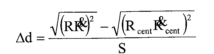
- Length estimation routine 130 begins at step 132 and proceeds to step 134 to calculate a lengthwise deviation ⁇ d for a data pair (R, ) using estimates of speed S, centroid range R cent , and centroid range rate cent , of the object centroid C. Since raw radar signal returns are interpreted in the W-plane as lengthwise deviations ⁇ d from the centroid C, the lengthwise deviation ⁇ d is the difference in value of distance d between a radar signal return and the tracked centroid C.
- the lengthwise deviation ⁇ d can be estimated according to the following equation: where ⁇ d is the lengthwise deviation between the scattering center producing the radar signal return and the location of the tracked centroid C, R is the raw range, is the raw range rate, R cent is the estimated range to the centroid, cent is the estimated centroid range rate, and S is the estimated target relative speed.
- the lengthwise deviation ⁇ d is monitored to detect the lengthwise deviations for the rear and front of the object, referred to herein as deviations d HIGH and d LOW , respectively.
- the quantities d HIGH and d LOW describe an envelope about the centroid C.
- routine 130 determines if the lengthwise deviation ⁇ d is outside of the envelope and, if so, the envelope is modified in step 138.
- the envelope is stretched only partway in order to provide some noise immunity.
- the coefficient defining the partway stretching may be adjusted to balance between measurement noise and the frequency with which extreme points on the object are expected to appear in the radar signal returns. If the extreme points are expected to be visible quite frequently, then the partway coefficient does not need to be very large.
- step 140 length estimation routine 130 checks for whether there are more (R, ) pairs to process and, if so, returns to step 134. If there are no more (R, ) pairs to process, routine 130 proceeds to step 142 to shrink the envelope boundaries by a shrinking factor for noise immunity. The envelope boundaries are shrunk towards the centroid with time, according to a calibration time constant. This provides further noise immunity by mitigating the effect of noisy returns over time.
- the object length L is estimated as the width of the envelope (d HIGH - d LOW ) in step 144. Accordingly, the length L of the object is estimated as the difference between the upper and lower edges of the envelope (d HIGH - d LOW ). Finally, routine 130 ends at step 146.
- the estimation of the width W dimension uses a batch of recent measurements 64 (e.g., 300 milliseconds) plotted as points in the W-plane, such as shown in FIG. 9.
- the speed S of the target object defines a line slope in the W-plane.
- Parallel lines 92 and 94 are shown having a slope in the neighborhood of the speed-indicated slope are found which have minimum vertical separation and which enclose all or substantially all of the points 64 plotted in the W-plane.
- the vertical distance between parallel lines 82 and 84 is shown as M 2 / HIGH - M 2 / LOW which provides an indication of the object width W.
- the raw width W measurements are lightly filtered to produce final width estimates.
- Width estimation routine 150 begins at step 152 and proceeds to step 154 to select a set of W-plane slopes in the neighborhood of slope 1 / S 2 indicated by the estimated speed of the object.
- routine 150 finds squeezing lines 92 and 94 for the particular slope value. Based on the squeezing lines 92 and 94, width estimation routine 150 calculates the object width W in step 158.
- the width estimation routine 150 checks, in decision step 160, if the width W is the smallest value at this time and, if so, saves the width value W and miss distance M in step 162. Otherwise, routine 150 proceeds to decision step 164 to check if there are more slopes to process and, if so, returns to step 156. If there are no more slopes to process, routine 150 updates the filtered width in step 166 using the minimum width W, and also updates the filtered miss distance in step 168 using the minimum miss distance M of all points detected on the distributed object 16, before ending in step 170. Accordingly, the width W of the object is estimated as a function of the squeezing lines 92 and 94 defined by the measured points in the W-plane.
- the collision detection system 18 and routines of estimating miss distance M and length L and width W of an object advantageously estimate the miss distance M of a target object and estimate length L and width W dimensions of the object without requiring the measurement of an azimuth angle of the object.
- the present invention is able to employ less complex and less expensive sensing components, thus providing cost savings.
- the collision detection system 18 advantageously estimates an anticipated collision and allows for timely responsive action to be taken.
- the estimated length and width dimensions enable the collision detection system 18 to better determine the type of countermeasures to be employed. If the size of the object is sufficiently small, the collision detection system 18 may decide not to employ any countermeasures.
- the collision detection system 18 may employ countermeasures to a greater degree as compared to smaller objects. Further, it should be appreciated that the estimated width W enables enhanced accuracy estimation of the miss distance M by advantageously estimating the miss distance to the closest point on a distributed object.
Abstract
Description
- The present invention generally relates to object detection and, more particularly, relates to a vehicle object detection system and method of estimating the size of an object such as length and width dimensions.
- Automotive vehicles are increasingly being equipped with collision avoidance and warning systems for predicting the potential collision with an external object, such as another vehicle or a pedestrian. Upon detecting a potential collision, such systems typically initiate an action to avoid the collision and/or provide a warning to the vehicle operator. Adaptive cruise control systems have been proposed to track a leading vehicle and automatically control the speed of the following vehicle. The ability to accurately predict an upcoming collision also enables a vehicle controller to control and deploy safety-related devices on the vehicle. For example, upon predicting an anticipated collision or near collision with an object, the vehicle seat belt pretensioner could be activated in a timely manner to pretension the seat belt, thereby enhancing the application of the safety device. The controller could also deploy a warning signal to notify the vehicle driver of a predicted collision with an object.
- In conventional target tracking systems employed on automotive vehicles, the host vehicle is generally equipped with a sensor arrangement that acquires range, range rate, and azimuth angle (i.e., direction to target) measurements for each tracked target within a field of view. The sensor arrangement employed in many conventional collision detection systems is generally complex and costly and includes a plurality of radar beams or laser beams covering a field of view. In order to detect an anticipated vehicle collision with an object, the conventional collision detection system generally senses the presence of an object, tracks the movement of the sensed object, measures the azimuth angle of the object, range to the object, and range rate of the object, all relative to the host vehicle.
- In addition to detecting the presence of an anticipated collision with an object it is also desirable to know the size of the object in order to determine whether or not to deploy one or more countermeasures and, if so, to further determine what type of countermeasures to deploy. For example, for an anticipated collision with a relatively large object, such as another vehicle or a pedestrian, it may be desirable to deploy certain countermeasures such as pretensioning the seat belt and deploying one or more air bags. However, for relatively small objects, such as a beverage container, no countermeasure deployment may be necessary. Further, it may be desirable to differentiate between certain types of objects, such as a pedestrian and a vehicle so as to deploy different countermeasures depending on the object size and/or type of object.
- The above-mentioned prior known collision detection systems generally require relatively complex and expensive sensor arrangements which use multiple sensors that are required to measure the azimuth angle of the object, relative to the host vehicle, in addition to obtaining the range and range rate measurements. It is generally desirable to reduce the complexity and cost of systems and components employed in automotive vehicles.
- It is therefore desirable to provide for a vehicle collision detection system which is able to estimate miss distance of an object and predict a potential collision with an approaching object that offers reduced complexity and cost. It is further desirable to provide for a cost affordable detection system and method of estimating the size of the object.
- In accordance with the teachings of the present invention, a detection system and method of estimating a size dimension of an object are provided. According to one aspect of the present invention, the detection system includes a sensor for sensing an object within a field of view. The sensor measures range and range rate of the sensed object. The detection system further includes a controller for estimating a size dimension of the object as a function of the range and range rate. The controller estimates the size dimension absent an azimuth angle measurement of the object.
- According to another aspect of the present invention, a method of estimating a size dimension of an object is provided. The method includes the steps of sensing the presence of an object, tracking the sensed object, measuring range to the object for each of a plurality of measurements, and determining range rate of the object for each of the plurality of measurements. The method also includes the steps of estimating a size dimension of the object as a function of the range and the range rate. The size dimension is estimated absent an azimuth angle measurement.
- Accordingly, the detection system and method of estimating a size dimension of an object according to the present invention advantageously estimates a size dimension (e.g., length or width) of an object without requiring a complex and costly sensor arrangement, such as those which determine an azimuth angle measurement of the object.
- These and other features, advantages and objects of the present invention will be further understood and appreciated by those skilled in the art by reference to the following specification, claims and appended drawings.
- The present invention will now be described, by way of example, with reference to the accompanying drawings, in which:
- FIG. 1 is a plan view illustrating the geometry of a collision detection system employed on a vehicle;
- FIG. 2 is a block diagram illustrating the collision detection system;
- FIG. 3 is a block diagram illustrating the length, width, and miss distance estimator of the collision detection system;
- FIG. 4 is a flow diagram illustrating a routine for estimating and using the miss distance in collision detection;
- FIG. 5 is a graph illustrating estimation of the miss distance using a curve in a W-plane defined by range squared and the product of range and range rate squared;
- FIG. 6 is a graph illustrating estimation of length and width dimensions of an object using a curve in the W-plane;
- FIGS. 7A and 7B are plan views illustrating the geometry of an object having dimensions estimated according to the present invention;
- FIG. 8 is a plan view illustrating detection of a tall thin object;
- FIG. 9 is a graph illustrating a pair of squeezing lines for estimating width of the object according to the present invention;
- FIG. 10 is a flow diagram illustrating a routine for estimating size dimensions of an object and predicting the type of object;
- FIG. 11 is a flow diagram illustrating a routine for estimating length of an object according to the present invention; and
- FIG. 12 is a routine for estimating width of an object according to the present invention.
-
- Referring to FIG. 1, an automotive vehicle 10 is generally illustrated having a collision detection system including a radar sensor 12 mounted thereto to cover a desired field of view 14 in front of the vehicle 10. The vehicle collision detection system senses and tracks one or more objects, such as moving target 16, and estimates a miss distance M for each sensed object. The miss distance M is the closest anticipated distance between the target 16 and the vehicle 10. Using the estimated miss distance M, the collision detection system is able to detect an anticipated collision between the vehicle 10 and the target 16, thereby allowing for responsive action to be taken. The collision detection system further estimates size dimensions of length and width of the object 16 by exploiting differences in range and range rate observed over the span of the distributed object. The estimated size dimensions of length and width of the object 16 provide a useful indication of the size of the object which can be useful in determining whether to deploy one or more countermeasures and what type of countermeasure(s) to deploy. The estimated length and width could further be useful in combination with information from other sensors, such as a camera to identify the location of an object in an image.
- The sensor 12 may include a single sensor or a plurality of sensors arranged to cover the field of view 14 to sense the presence of one or more objects. The sensor 12 also tracks the relative movement of each sensed object within the field of view 14. Sensor 12 measures the range (radial distance) R to the target object 16, and further measures the range rate (time rate of change of radial distance)of the target object 16. The range R is the measured radial distance between the vehicle 10 and the object 16 which is output from sensor 12 and may include sensor noise. The range rate

- The collision detection system and method of the present invention advantageously estimates the miss distance M and estimates length and width size dimensions of the object 16 as a function of the range and range rate measurements R and
- Referring to FIG. 2, the collision detection system 18 is shown including radar sensor 12 and a controller 20. Controller 20 preferably includes a microprocessor-based controller having a microprocessor 22 and memory 24. Memory 24 may include random access memory (RAM), read-only memory (ROM), and electrically erasable programmable read-only memory (EEPROM). Controller 20 may be a commercially available off-the-shelf controller and may be dedicated to precrash processing or object detection processing, or may share processing capability with other vehicle functions.
- The controller 20 receives the range measurement R and range rate measurement
- The controller 20 generates an output signal 26 in the event that an anticipated vehicle collision has been determined. The output signal 26 may be supplied as an input to one or more devices in the vehicle, such as a seat belt pretensioner 28, to activate the device(s) in anticipation of an anticipated upcoming collision. According to the example shown, the seat belt pretensioner 28 may be controlled to pretension the seat belt just prior to the anticipated vehicle collision to eliminate slack in the restraining device. The output signal 26 may be provided to one or more warning devices 30 to warn the vehicle operator and occupants of an anticipated vehicle collision. It should further be appreciated that other devices may be deployed as countermeasures including vehicle air bags, pop-up roll bars, and other safety-related devices.
- Referring to FIG. 3, an object length, width, and miss distance estimator 32 is generally shown receiving the range measurement R and range rate measurement
- The miss distance estimation and the object length and width estimations of the present invention assume that the target object 16 is moving straight and at a constant speed relative to the host vehicle 10. The target object heading (i.e., the direction of speed S on line 17) is assumed to be constant, however, if the target object 16 is not moving directly toward or away from the host vehicle 10, then the radial angle is changing. Hence, the miss angle γ is changing and the range rate
- Referring to FIG. 4, a routine 40 is illustrated for estimating the miss distance M of a target object and determining a collision detection signal 26. Routine 40 begins at step 42 and proceeds to step 44 to receive the sensor measurement data, including the range measurement R and range rate measurement
- Proceeding to step 48, routine 40 computes a mathematical square of the range R as shown by R2, and also computes a mathematical square of the product of range and range rate as shown by (R ·
- Proceeding to step 50, routine 40 generates a least-squares fit line (curve) for a window of recent data for the tracked object in a plane, referred to herein as the W-plane. The W-plane is defined as a plane having data plotted on X-axis and Y-axis coordinates, such as is shown in FIG. 5. The Y-axis coordinate represents the squared range R2 values, while the X-axis coordinate represents the squared product of range and range rate (R ·
- In step 52, routine 40 extracts estimates of the miss distance M and speed S of the object from the fitted line 66 shown in the W-plane. As seen in FIG. 5, the curve 66 crosses the vertical axis defined by the squared range R2 at a point 68 when the squared product of range and range rate (R ·

- The miss distance M and speed S may be estimated from an interpretation of the fitted curve 66. This relationship, according to one embodiment, is shown in the following equation:wherein 1 / S2 represents the slope of curve 66 as defined by horizontal segment 70 and vertical segment 72. Accordingly, the speed S of the object relative to the vehicle may be estimated based on the slope of curve 66. It should be appreciated that the miss distance M is the distance that the target object would have come closest to the vehicle 10 if the object continued along the instantaneous curve. For a target object which is moving straight at constant speed, the points plotted in the W-plane form a straight line with an intercept on the R2 axis having a value equal to M2 and with a slope of 1 / S2. While a straight line curve 66 is shown, it should be appreciated that some higher-order curve may be employed to define the relationship of the sample points.

- Referring back to FIG. 4 and proceeding to step 52, routine 40 calculates the time to closest point-of-approach TCPA for the target object. The time to closest point-of-approach TCPA can be calculated based on range, range rate, and a calculated acceleration of the object in the radial direction. Next, in decision step 56, routine 40 determines if the following two conditions are met: (1) is estimated miss distance M less than threshold 1; and (2) is TCPA less than threshold 2. If both conditions are met in step 56, routine 40 generates an output signal to provide a signal warning or to deploy countermeasures in step 58. The countermeasures may include pretensioning a seat belt pretensioner, providing a warning, or initiating other appropriate action. It should be appreciated that the estimated miss distance M may be used to determine if an imminent collision is anticipated or may be employed to determine if a close collision is anticipated. By estimating the time to closest point-of-approach TCPA, the time of an anticipated collision or a near collision event can be monitored and employed to timely employ any countermeasure devices such as a seat belt pretensioner. If either of the above conditions in step 56 is not met, routine 40 ends at step 60.
- The miss distance estimation assumes that the target object 16 is moving straight and at a constant speed relative to the host vehicle 10. If variations in speed and/or direction of the object 16 occur relative to the host vehicle 10, the successive instantaneous measurements will account for variations in direction or speed. While the miss distance estimation has been described in connection with a linear curve 66, it should be appreciated that higher-order curves (e.g., parabolas) may be employed. It should further be appreciated that the use of a weighting matrix in the curve fitting process (e.g., based on the inverse of range squared) and accounting for the correlation between errors in the two W-plane quantities in the curve fitting process may also be provided.
- The collision detection system of the present invention estimates the size of object 16 by estimating the length L and width W of the object moving through the field of view 14 of the radar sensor 12. In doing so, the vehicle collision detection system 18 processes a sequence of range and range rate measurements R and
- The following explanation of estimating length L and width W of the object 16 assumes that only one object is detected in the sensor field of view 14. However, it should be appreciated that multiple objects may be detected within the sensor field of view 14 by employing additional processing to associate such radar returns with each specific object tracked. It is also assumed that both the host vehicle 10 and the target object 16 are in uniform motion (moving straight at constant speed). The assumption of uniform motion allows for conceptual viewing of the host vehicle 10 as being stationary and focuses on relative velocity of the target object 16 relative to the host vehicle 10.
According to this assumption, the host vehicle 10 may be considered stationary, and therefore the target object' s velocity and the object' s velocity relative to the host vehicle are considered the same. - The length L and width W estimates are obtained by exploiting the differences in range and range rate of the distributed object 16 by analyzing the data in the W-plane. The data for consecutive sensed range and range rate measurements R and
- The vertical and horizontal axes of the W-plane can further be represented in terms of the miss distance M, the distance d between the sensed location on the object and the anticipated closest point-of-approach, and the relative speed S of the target object as shown in FIG. 6. Specifically, the vertical axis may also be represented by M2+d2, and the horizontal axis may also be represented by d2S2. The data shown in the W-plane of FIG. 6 is for a sensed target object having a relatively flat rectangular shape, such as an automotive vehicle, moving with a relative velocity that is parallel to the longitudinal axis of the target object (vehicle). Due to the distributed shape of the target object, the radar sensor signal returns from various locations on the object form a parallelogram pattern 80 in the W-plane. The pattern 80 moves in the W-plane as the object 16 moves relative to the host vehicle 10. The front edge of the object 16 defined by the near front (NF) corner and the far front (FF) corner has a constant distance d to closest point-of-approach and, because speed S is assumed to be constant, the corresponding points plotted in the W-plane have the same horizontal axis value. The points on the front edge of the object have differing miss distance M values, however, so the front edge of the object maps into a vertical line segment 86 in the W-plane. Likewise, the rear edge of the object 16 defined by the near rear (NR) corner and the far rear (FR) corner maps into a vertical line segment 88 in the W-plane. The points on the near side of the object 16 have the same miss distance M value, but differing distance d to closest point-of-approach values. Consequently, the near side of the object 16 maps into a sloped line segment 84 in the W-plane having a slope of 1 / S 2, whereas the far side of the object 16 likewise maps into a slope line segment 82 in the W-plane having a slope of 1 / S 2. Accordingly, the shape of the rectangular object is shown in FIG. 6 in the W-plane to be a parallelogram pattern 80. With radar signals returned and processed from various points on the distributed object 16, the length L of the object 16 can be estimated from the horizontal dimension of the parallelogram in the W-plane, and the width W is related to the length of the vertical edge dimension. By processing this information, the detection system of the present invention is able to estimate length L and width W of the object 16.
- A distributed object 16 is shown in FIG. 7A relative to a stationary host vehicle, and is also shown in FIG. 7B relative to a moving host vehicle. The length L of the object 16 is defined as the span of the object 16 in a direction parallel to the relative velocity vector V. The length L may further be defined as how close of a distance together two planes orthogonal to the relative velocity vector can be squeezed and still enclose the target object. For a stationary host vehicle 10 and a moving target vehicle 16, the length L is simply the length of the moving target vehicle 16. In a situation when both the host vehicle 10 and the target object 16 are moving, the relative velocity vector V may not be parallel to the longitudinal axis of the target object 16, in which case the length L of the object 16 may be somewhat corrupted by its width as seen in FIG. 7B. Similarly, the width W of the object 16 may be somewhat corrupted by the length as shown in FIG. 7B.
- The width W is defined as the measurement direction orthogonal to the relative velocity vector V. It can be assumed in some situations that the target object 16 has a negligible height. If the object has a non-negligible height that is readily viewable in the field of view 14 of the sensor 12, then the width estimate W may be corrupted by the height. An example of non-negligible height of an object is illustrated in FIG. 8 in which the sensor 12 is shown detecting a tall thin pole 90 having a relatively small width and a large vertical height. The radial distance R1 depicts the shortest range to the target object, and radial distance R2 depicts the longest range to the target object. The width W of the pole is estimated as the difference in distance R1 and R2 (R2-R1). Ranges R1 and R2 are measured in cross section view only and generally are not the shortest and longest ranges to parts of the target host, except when it is at the closest point-of-approach.
- To estimate length L and width W of an object, the detection system tracks some point on the target object and relies on occasional radar signal returns from a variety of locations over the span of the distributed object to estimate dimensions of target length L and width W by deviations from the tracked point. This is because generally radar signal returns are not consistently available from all points on the object. The tracked point may be the center point as shown in FIGS. 7A and 7B or any other point and is referred to herein as the centroid C. Tracking of the centroid C is referred to herein as centroid tracking. The centroid tracking occurs in the range-range rate plane and is mapped into the W-plane for comparison to raw radar signal returns.
- A routine 100 is illustrated in FIG. 10 for estimating the length and width dimensions of an object, predicting the object type, and deciding on any countermeasures according to the present invention. The routine 100 begins at step 102 and proceeds to receive range and range rate measurements R and
- In step 114, routine 100 estimates the dimension of length L of the object according to the present invention. The object length L estimation is generated by length estimation routine 130 which is shown particularly in FIG. 11 and described below. The object width W is estimated in step 116, and is generated by routine 150 which is particularly shown in FIG. 12 and described below. Routine 100 further estimates the miss distance M of the object at the closest point-of-approach in step 118. By estimating object length L and width W, routine 100 may be able to predict the type of object in step 120 based on the estimated size dimensions of width W and length L. Prediction of the type of object may include comparing the estimated size dimensions to known object criteria, such as size dimensions of vehicles, pedestrians, and other objects. Finally, routine 100 decides on any countermeasures to deploy based on the object type in step 122. Countermeasures may include pretensioning a seat belt pretensioner just prior to an anticipated collision, warning the driver of an anticipated collision, or performing any other action. It should be appreciated that the type of countermeasure deployed may be dependent on the predicted size of the object. In addition, routine 100 may decide not to deploy any countermeasures based on detection of an object of a sufficiently small size. Finally, routine 100 ends in step 124.
- Referring particularly to FIG. 11, the routine 130 for estimating length L of the object is illustrated therein. Length estimation routine 130 begins at step 132 and proceeds to step 134 to calculate a lengthwise deviation Δd for a data pair (R,
- The lengthwise deviation Δd is monitored to detect the lengthwise deviations for the rear and front of the object, referred to herein as deviations dHIGH and dLOW, respectively. The quantities dHIGH and dLOW describe an envelope about the centroid C. When a value of the lengthwise deviation Δd is calculated which is outside of the envelope (dHIGH - dLOW), the appropriate envelope boundary is stretched outward partway toward the new value. This is shown in decision step 136 in which routine 130 determines if the lengthwise deviation Δd is outside of the envelope and, if so, the envelope is modified in step 138. The envelope is stretched only partway in order to provide some noise immunity. The coefficient defining the partway stretching may be adjusted to balance between measurement noise and the frequency with which extreme points on the object are expected to appear in the radar signal returns. If the extreme points are expected to be visible quite frequently, then the partway coefficient does not need to be very large.
- In decision step 140, length estimation routine 130 checks for whether there are more (R,
- The estimation of the width W dimension uses a batch of recent measurements 64 (e.g., 300 milliseconds) plotted as points in the W-plane, such as shown in FIG. 9. The speed S of the target object defines a line slope in the W-plane. Parallel lines 92 and 94 are shown having a slope in the neighborhood of the speed-indicated slope are found which have minimum vertical separation and which enclose all or substantially all of the points 64 plotted in the W-plane. The vertical distance between parallel lines 82 and 84 is shown as M 2 / HIGH - M 2 / LOW which provides an indication of the object width W. The raw width W measurements are lightly filtered to produce final width estimates.
- Referring to FIG. 12, a routine 150 for estimating width W of an object is illustrated therein. Width estimation routine 150 begins at step 152 and proceeds to step 154 to select a set of W-plane slopes in the neighborhood of slope 1 / S 2 indicated by the estimated speed of the object. Next, in step 156, routine 150 finds squeezing lines 92 and 94 for the particular slope value. Based on the squeezing lines 92 and 94, width estimation routine 150 calculates the object width W in step 158. Width W is shown computed as a function of the square root of the maximum miss distance squared (M 2 / HIGH) minus the minimum miss distance squared (M 2 / LOW) according to the following equation:
- The width estimation routine 150 checks, in decision step 160, if the width W is the smallest value at this time and, if so, saves the width value W and miss distance M in step 162. Otherwise, routine 150 proceeds to decision step 164 to check if there are more slopes to process and, if so, returns to step 156. If there are no more slopes to process, routine 150 updates the filtered width in step 166 using the minimum width W, and also updates the filtered miss distance in step 168 using the minimum miss distance M of all points detected on the distributed object 16, before ending in step 170. Accordingly, the width W of the object is estimated as a function of the squeezing lines 92 and 94 defined by the measured points in the W-plane.
- An alternative approach to estimating width W of the object could be made analogous to the estimation of length L as described above, in which a centroid C is tracked and vertical deviations of raw radar signal returns from the centroid C in the W-plane are interpreted as providing width envelope information.
- Accordingly, the collision detection system 18 and routines of estimating miss distance M and length L and width W of an object advantageously estimate the miss distance M of a target object and estimate length L and width W dimensions of the object without requiring the measurement of an azimuth angle of the object. As a consequence, the present invention is able to employ less complex and less expensive sensing components, thus providing cost savings. By processing the estimated miss distance M, the collision detection system 18 advantageously estimates an anticipated collision and allows for timely responsive action to be taken. The estimated length and width dimensions enable the collision detection system 18 to better determine the type of countermeasures to be employed. If the size of the object is sufficiently small, the collision detection system 18 may decide not to employ any countermeasures. For larger objects, the collision detection system 18 may employ countermeasures to a greater degree as compared to smaller objects. Further, it should be appreciated that the estimated width W enables enhanced accuracy estimation of the miss distance M by advantageously estimating the miss distance to the closest point on a distributed object.
- It will be understood by those who practice the invention and those skilled in the art, that various modifications and improvements may be made to the invention without departing from the spirit of the disclosed concept. The scope of protection afforded is to be determined by the claims and by the breadth of interpretation allowed by law.
Claims (21)
- A detection system for detecting a size dimension (L, W) of an object (16), said system comprising:a sensor (12) for sensing an object (16) in a field of view (14) and measuring range (R) to the object (16) and determining range rate () of the object (16); and
 a controller (20) for estimating a size dimension (L, W) of the object (16) as a function of the range (R) and range rate (
 - The detection system as defined in claim 1, wherein the size dimension comprises length (L) of the object (16).
- The detection system as defined in claim 2, wherein the controller (20) further computes a mathematical square of the range (R2) and computes a mathematical square of the product of range and range rate (R ·
- The detection system as defined in claim 3, wherein the controller (20) estimates length (L) of the object (16) as a function of lengthwise deviation of the signals received from various locations on the distributed object (16).
- The detection system as defined in claim 1, wherein the size dimension comprises width (W) of the object (16).
- The detection system as defined in claim 5, wherein the controller (20) further computes a mathematical square of the range (R2) and computes a mathematical square of the product of range and range rate (R ·
- The detection system as defined in claim 6, wherein the controller (20) determines a pair of squeezing lines (92, 94) defining a plurality of measurements, wherein the width (W) of the object (16) is estimated as a function of the pair of squeezing lines (92, 94).
- The detection system as defined in claim 1, wherein the sensor (12) is located on a vehicle (10).
- The detection system as defined in claim 1, wherein the sensor (12) comprises a radar sensor.
- The detection system as defined in claim 9, wherein the range rate (
- The detection system as defined in claim 1, wherein the controller (20 further estimates miss distance (M) of the object (16).
- The detection system as defined in claim 11, wherein the controller (20) computes miss distance (M) as a function of the estimated size dimension (L, W) of the object (16).
- A method of estimating a size dimension (L, W) of an object (16), said method comprising the steps of:sensing the presence of an object (16);tracking the object;measuring (104) range (R) to the object;determining (104) range rate (
- The method as defined in claim 13, wherein the step of tracking the object comprises tracking the object (16) relative to a vehicle (10).
- The method as defined in claim 13, wherein the step of estimating a size dimension of the object comprises estimating (114) length (L) of the object (16).
- The method as defined in claim 15 further comprising the steps of:computing a mathematical square of range (R2) for each of the plurality of measurements; andcomputing a mathematical square of the product of range and range rate (R ·
- The method as defined in claim 13, wherein the step of estimating a size dimension of the object comprises the step of estimating (116) width (W) of the object (16).
- The method as defined in claim 17 further comprising the steps of:computing a mathematical square of range (R2) for each of the plurality of measurements; andcomputing a mathematical square of the product of range and range rate (R ·
- The method as defined in claim 13, wherein the step of determining range rate (
- The method as defined in claim 13 further comprising the step of estimating (118) miss distance (M) of the object (16).
- The method as defined in claim 20, wherein the step of estimating miss distance (M) comprises estimating miss distance as a function of the estimated size dimension (L, W) of the object (16).
Applications Claiming Priority (2)
| Application Number | Priority Date | Filing Date | Title |
|---|---|---|---|
| US10/186,784 US6794987B2 (en) | 2002-07-01 | 2002-07-01 | Object detection system and method of estimating object size |
| US186784 | 2002-07-01 |
Publications (2)
| Publication Number | Publication Date |
|---|---|
| EP1378764A1 true EP1378764A1 (en) | 2004-01-07 |
| EP1378764B1 EP1378764B1 (en) | 2012-08-15 |
Family
ID=29720406
Family Applications (1)
| Application Number | Title | Priority Date | Filing Date |
|---|---|---|---|
| EP03076972A Expired - Lifetime EP1378764B1 (en) | 2002-07-01 | 2003-06-25 | Object detection system and method of estimating object size |
Country Status (2)
| Country | Link |
|---|---|
| US (1) | US6794987B2 (en) |
| EP (1) | EP1378764B1 (en) |
Cited By (1)
| Publication number | Priority date | Publication date | Assignee | Title |
|---|---|---|---|---|
| CN105842684A (en) * | 2015-02-04 | 2016-08-10 | 通用汽车环球科技运作有限责任公司 | Vehicle motion estimation enhancement with radar data |
Families Citing this family (30)
| Publication number | Priority date | Publication date | Assignee | Title |
|---|---|---|---|---|
| DE10128792B4 (en) * | 2001-05-08 | 2005-06-09 | Daimlerchrysler Ag | Collision protection for vehicles |
| JP2004177350A (en) * | 2002-11-28 | 2004-06-24 | Denso Corp | Radar equipment for vehicle |
| JP2005004364A (en) * | 2003-06-10 | 2005-01-06 | Mitsubishi Electric Corp | Vehicle safety device |
| DE10342128A1 (en) * | 2003-09-12 | 2005-04-07 | Valeo Schalter Und Sensoren Gmbh | Method and distance detection device for determining the distance between at least one sensor device and an object |
| US7069130B2 (en) * | 2003-12-09 | 2006-06-27 | Ford Global Technologies, Llc | Pre-crash sensing system and method for detecting and classifying objects |
| US7389171B2 (en) * | 2003-12-22 | 2008-06-17 | Ford Global Technologies Llc | Single vision sensor object detection system |
| US7289019B1 (en) * | 2004-05-13 | 2007-10-30 | Jon Kertes | Vehicle avoidance collision system |
| DE102004028763A1 (en) * | 2004-06-16 | 2006-01-19 | Daimlerchrysler Ag | Andockassistent |
| US7818127B1 (en) * | 2004-06-18 | 2010-10-19 | Geneva Aerospace, Inc. | Collision avoidance for vehicle control systems |
| JP4895484B2 (en) * | 2004-06-28 | 2012-03-14 | 富士通テン株式会社 | Axis deviation calculation method for on-vehicle radar device and on-vehicle radar axis deviation determination method |
| JP4539348B2 (en) * | 2004-09-07 | 2010-09-08 | 日産自動車株式会社 | Collision time calculation device and obstacle detection device |
| US8629800B2 (en) * | 2004-09-30 | 2014-01-14 | The Boeing Company | Ground vehicle collision prevention systems and methods |
| US7379165B2 (en) * | 2004-09-30 | 2008-05-27 | The Boeing Company | Ground vehicle collision prevention systems and methods |
| US7480570B2 (en) * | 2004-10-18 | 2009-01-20 | Ford Global Technologies Llc | Feature target selection for countermeasure performance within a vehicle |
| US7339519B2 (en) * | 2005-07-12 | 2008-03-04 | Lockheed Martin Corporation | Methods and apparatus for target radial extent determination using deconvolution |
| GB2433122B (en) | 2005-12-10 | 2008-07-23 | Endet Ltd | Gas sampling probe |
| US8358342B2 (en) * | 2007-02-23 | 2013-01-22 | Johnson Controls Technology Company | Video processing systems and methods |
| US8270767B2 (en) | 2008-04-16 | 2012-09-18 | Johnson Controls Technology Company | Systems and methods for providing immersive displays of video camera information from a plurality of cameras |
| US20090307255A1 (en) * | 2008-06-06 | 2009-12-10 | Johnson Controls Technology Company | Graphical management of building devices |
| JP4831442B2 (en) * | 2008-12-24 | 2011-12-07 | トヨタ自動車株式会社 | Collision determination device |
| US9511751B2 (en) | 2011-07-22 | 2016-12-06 | GM Global Technology Operations LLC | Object identification and active safety control for vehicles |
| KR101338062B1 (en) * | 2011-11-15 | 2014-01-06 | 기아자동차주식회사 | Apparatus and method for managing pre-crash system for vehicle |
| US20130229298A1 (en) * | 2012-03-02 | 2013-09-05 | The Mitre Corporation | Threaded Track Method, System, and Computer Program Product |
| US8896747B2 (en) * | 2012-11-13 | 2014-11-25 | Qualcomm Technologies, Inc. | Depth estimation based on interpolation of inverse focus statistics |
| US20140176714A1 (en) * | 2012-12-26 | 2014-06-26 | Automotive Research & Test Center | Collision prevention warning method and device capable of tracking moving object |
| JP6369035B2 (en) * | 2013-02-05 | 2018-08-08 | 株式会社デンソー | Target detection device |
| CN111199218A (en) * | 2014-01-30 | 2020-05-26 | 移动眼视力科技有限公司 | Control system for vehicle, and image analysis system |
| JP6265095B2 (en) * | 2014-09-24 | 2018-01-24 | 株式会社デンソー | Object detection device |
| US10175348B2 (en) | 2014-10-08 | 2019-01-08 | Src, Inc. | Use of range-rate measurements in a fusion tracking system via projections |
| US11113824B2 (en) | 2019-04-30 | 2021-09-07 | Aptiv Technologies Limited | Heading angle estimation for object tracking |
Citations (3)
| Publication number | Priority date | Publication date | Assignee | Title |
|---|---|---|---|---|
| US5191337A (en) * | 1992-02-25 | 1993-03-02 | Hughes Aircraft Company | Ranging, detection and resolving in a multislope frequency modulated waveform radar system |
| US5818355A (en) * | 1995-12-26 | 1998-10-06 | Denso Corporation | Automotive anti-collision and alarm system |
| US6085151A (en) * | 1998-01-20 | 2000-07-04 | Automotive Systems Laboratory, Inc. | Predictive collision sensing system |
Family Cites Families (15)
| Publication number | Priority date | Publication date | Assignee | Title |
|---|---|---|---|---|
| US4626850A (en) * | 1983-05-16 | 1986-12-02 | David Chey | Vehicle detection and collision avoidance apparatus |
| US4818107A (en) * | 1986-05-21 | 1989-04-04 | Kabushiki Kaisha Komatsu S Eisakusho | System for measuring the position of a moving body |
| KR900008856B1 (en) * | 1986-06-12 | 1990-12-11 | 미쓰비시 뎅끼 가부시끼가이샤 | Navigation apparatus for vehicle |
| US5249157A (en) | 1990-08-22 | 1993-09-28 | Kollmorgen Corporation | Collision avoidance system |
| JPH04270373A (en) * | 1991-01-17 | 1992-09-25 | Mitsubishi Electric Corp | On-vehicle navigation device |
| JPH05172575A (en) * | 1991-12-19 | 1993-07-09 | Pioneer Electron Corp | Navigation equipment |
| JP3366225B2 (en) * | 1997-07-09 | 2003-01-14 | 本田技研工業株式会社 | Navigation device and vehicle control device |
| US6002974A (en) | 1998-02-06 | 1999-12-14 | Delco Electronics Corporation | Vehicle rollover sensing using extended kalman filter |
| US6594614B2 (en) | 2000-04-17 | 2003-07-15 | Delphi Technologies, Inc. | Vehicle back-up aid system |
| US6404328B1 (en) | 2000-10-24 | 2002-06-11 | Delphi Technologies, Inc. | Discrimination of detected objects in a vehicle path |
| US6581006B2 (en) | 2001-01-03 | 2003-06-17 | Delphi Technologies, Inc. | System and method for barrier proximity detection |
| US6469659B1 (en) | 2001-05-03 | 2002-10-22 | Delphi Technologies, Inc. | Apparatus and method for detecting radar obstruction |
| US6438477B1 (en) | 2002-02-27 | 2002-08-20 | Delphi Technologies, Inc. | Vehicle seat occupant characterization method including empty seat detection |
| US6583753B1 (en) | 2002-04-03 | 2003-06-24 | Delphi Technologies, Inc. | Vehicle back-up and parking aid radar system |
| US6615138B1 (en) * | 2002-05-30 | 2003-09-02 | Delphi Technologies, Inc. | Collision detection system and method of estimating miss distance employing curve fitting |
-
2002
- 2002-07-01 US US10/186,784 patent/US6794987B2/en not_active Expired - Lifetime
-
2003
- 2003-06-25 EP EP03076972A patent/EP1378764B1/en not_active Expired - Lifetime
Patent Citations (3)
| Publication number | Priority date | Publication date | Assignee | Title |
|---|---|---|---|---|
| US5191337A (en) * | 1992-02-25 | 1993-03-02 | Hughes Aircraft Company | Ranging, detection and resolving in a multislope frequency modulated waveform radar system |
| US5818355A (en) * | 1995-12-26 | 1998-10-06 | Denso Corporation | Automotive anti-collision and alarm system |
| US6085151A (en) * | 1998-01-20 | 2000-07-04 | Automotive Systems Laboratory, Inc. | Predictive collision sensing system |
Cited By (2)
| Publication number | Priority date | Publication date | Assignee | Title |
|---|---|---|---|---|
| CN105842684A (en) * | 2015-02-04 | 2016-08-10 | 通用汽车环球科技运作有限责任公司 | Vehicle motion estimation enhancement with radar data |
| US9903945B2 (en) | 2015-02-04 | 2018-02-27 | GM Global Technology Operations LLC | Vehicle motion estimation enhancement with radar data |
Also Published As
| Publication number | Publication date |
|---|---|
| EP1378764B1 (en) | 2012-08-15 |
| US20040000991A1 (en) | 2004-01-01 |
| US6794987B2 (en) | 2004-09-21 |
Similar Documents
| Publication | Publication Date | Title |
|---|---|---|
| US6794987B2 (en) | Object detection system and method of estimating object size | |
| US7777618B2 (en) | Collision detection system and method of estimating target crossing location | |
| US6873251B2 (en) | Tracking system and method employing multiple overlapping sensors | |
| EP1367411B1 (en) | Collision detection system and method of estimating miss distance | |
| US6888447B2 (en) | Obstacle detection device for vehicle and method thereof | |
| EP1367410B1 (en) | Collision detection system and method of estimating miss distance employing curve fitting | |
| US6687577B2 (en) | Simple classification scheme for vehicle/pole/pedestrian detection | |
| JP4857840B2 (en) | Object detection method and object detection apparatus | |
| US6775605B2 (en) | Remote sensing based pre-crash threat assessment system | |
| US20030076981A1 (en) | Method for operating a pre-crash sensing system in a vehicle having a counter-measure system | |
| US6628227B1 (en) | Method and apparatus for determining a target vehicle position from a source vehicle using a radar | |
| US20040239509A1 (en) | Target awareness determination system and method | |
| CN109080628B (en) | Target determination device and driving assistance system | |
| US20020057195A1 (en) | Method and apparatus for estimating inter-vehicle distance using radar and camera | |
| US20040019420A1 (en) | Method for determining a danger zone for a pre-crash sensing system in a vehicle having a countermeasure system | |
| US9123251B2 (en) | Image system for automotive safety applications | |
| US20080266167A1 (en) | Object Recognition System for a Motor Vehicle | |
| US10929653B2 (en) | Method for the recognition of a moving pedestrian | |
| JP2001099930A (en) | Sensor for monitoring periphery | |
| US6650983B1 (en) | Method for classifying an impact in a pre-crash sensing system in a vehicle having a countermeasure system | |
| US6650984B1 (en) | Method for determining a time to impact in a danger zone for a vehicle having a pre-crash sensing system | |
| US7130730B2 (en) | Sensing strategy for damage mitigation in compatability situations | |
| US20050004719A1 (en) | Device and method for determining the position of objects in the surroundings of a motor vehicle | |
| US20040117115A1 (en) | Method for identifying obstacles for a motor vehicle, using at least three distance sensors for identifying the laterla extension of an object | |
| JP6818902B6 (en) | Vehicle detection system |
Legal Events
| Date | Code | Title | Description |
|---|---|---|---|
| PUAI | Public reference made under article 153(3) epc to a published international application that has entered the european phase |
Free format text: ORIGINAL CODE: 0009012 |
|
| AK | Designated contracting states |
Kind code of ref document: A1 Designated state(s): AT BE BG CH CY CZ DE DK EE ES FI FR GB GR HU IE IT LI LU MC NL PT RO SE SI SK TR |
|
| AX | Request for extension of the european patent |
Extension state: AL LT LV MK |
|
| 17P | Request for examination filed |
Effective date: 20040707 |
|
| AKX | Designation fees paid |
Designated state(s): DE FR GB |
|
| 17Q | First examination report despatched |
Effective date: 20061128 |
|
| GRAP | Despatch of communication of intention to grant a patent |
Free format text: ORIGINAL CODE: EPIDOSNIGR1 |
|
| GRAS | Grant fee paid |
Free format text: ORIGINAL CODE: EPIDOSNIGR3 |
|
| GRAA | (expected) grant |
Free format text: ORIGINAL CODE: 0009210 |
|
| AK | Designated contracting states |
Kind code of ref document: B1 Designated state(s): DE FR GB |
|
| REG | Reference to a national code |
Ref country code: GB Ref legal event code: FG4D |
|
| REG | Reference to a national code |
Ref country code: DE Ref legal event code: R096 Ref document number: 60341809 Country of ref document: DE Effective date: 20121011 |
|
| PLBE | No opposition filed within time limit |
Free format text: ORIGINAL CODE: 0009261 |
|
| STAA | Information on the status of an ep patent application or granted ep patent |
Free format text: STATUS: NO OPPOSITION FILED WITHIN TIME LIMIT |
|
| 26N | No opposition filed |
Effective date: 20130516 |
|
| REG | Reference to a national code |
Ref country code: DE Ref legal event code: R097 Ref document number: 60341809 Country of ref document: DE Effective date: 20130516 |
|
| REG | Reference to a national code |
Ref country code: FR Ref legal event code: PLFP Year of fee payment: 14 |
|
| REG | Reference to a national code |
Ref country code: FR Ref legal event code: PLFP Year of fee payment: 15 |
|
| REG | Reference to a national code |
Ref country code: FR Ref legal event code: PLFP Year of fee payment: 16 |
|
| REG | Reference to a national code |
Ref country code: DE Ref legal event code: R081 Ref document number: 60341809 Country of ref document: DE Owner name: APTIV TECHNOLOGIES LIMITED, BB Free format text: FORMER OWNER: DELPHI TECHNOLOGIES, INC., TROY, MICH., US |
|
| REG | Reference to a national code |
Ref country code: GB Ref legal event code: 732E Free format text: REGISTERED BETWEEN 20190117 AND 20190123 |
|
| REG | Reference to a national code |
Ref country code: GB Ref legal event code: 732E Free format text: REGISTERED BETWEEN 20190124 AND 20190130 |
|
| PGFP | Annual fee paid to national office [announced via postgrant information from national office to epo] |
Ref country code: FR Payment date: 20190625 Year of fee payment: 17 |
|
| PG25 | Lapsed in a contracting state [announced via postgrant information from national office to epo] |
Ref country code: FR Free format text: LAPSE BECAUSE OF NON-PAYMENT OF DUE FEES Effective date: 20200630 |
|
| PGFP | Annual fee paid to national office [announced via postgrant information from national office to epo] |
Ref country code: GB Payment date: 20220617 Year of fee payment: 20 Ref country code: DE Payment date: 20220621 Year of fee payment: 20 |
|
| P01 | Opt-out of the competence of the unified patent court (upc) registered |
Effective date: 20230425 |
|
| REG | Reference to a national code |
Ref country code: DE Ref legal event code: R071 Ref document number: 60341809 Country of ref document: DE |
|
| REG | Reference to a national code |
Ref country code: GB Ref legal event code: PE20 Expiry date: 20230624 |
|
| PG25 | Lapsed in a contracting state [announced via postgrant information from national office to epo] |
Ref country code: GB Free format text: LAPSE BECAUSE OF EXPIRATION OF PROTECTION Effective date: 20230624 |