EP1662837A2 - Method and system for storage and fast retrieval of digital terrain model elevations for use in positioning systems - Google Patents
Method and system for storage and fast retrieval of digital terrain model elevations for use in positioning systems Download PDFInfo
- Publication number
- EP1662837A2 EP1662837A2 EP06004083A EP06004083A EP1662837A2 EP 1662837 A2 EP1662837 A2 EP 1662837A2 EP 06004083 A EP06004083 A EP 06004083A EP 06004083 A EP06004083 A EP 06004083A EP 1662837 A2 EP1662837 A2 EP 1662837A2
- Authority
- EP
- European Patent Office
- Prior art keywords
- elevation
- data
- digital
- location
- compressed
- Prior art date
- Legal status (The legal status is an assumption and is not a legal conclusion. Google has not performed a legal analysis and makes no representation as to the accuracy of the status listed.)
- Granted
Links
Images


Classifications
-
- G—PHYSICS
- G01—MEASURING; TESTING
- G01S—RADIO DIRECTION-FINDING; RADIO NAVIGATION; DETERMINING DISTANCE OR VELOCITY BY USE OF RADIO WAVES; LOCATING OR PRESENCE-DETECTING BY USE OF THE REFLECTION OR RERADIATION OF RADIO WAVES; ANALOGOUS ARRANGEMENTS USING OTHER WAVES
- G01S5/00—Position-fixing by co-ordinating two or more direction or position line determinations; Position-fixing by co-ordinating two or more distance determinations
- G01S5/02—Position-fixing by co-ordinating two or more direction or position line determinations; Position-fixing by co-ordinating two or more distance determinations using radio waves
- G01S5/0205—Details
- G01S5/0236—Assistance data, e.g. base station almanac
-
- G—PHYSICS
- G01—MEASURING; TESTING
- G01C—MEASURING DISTANCES, LEVELS OR BEARINGS; SURVEYING; NAVIGATION; GYROSCOPIC INSTRUMENTS; PHOTOGRAMMETRY OR VIDEOGRAMMETRY
- G01C21/00—Navigation; Navigational instruments not provided for in groups G01C1/00 - G01C19/00
- G01C21/005—Navigation; Navigational instruments not provided for in groups G01C1/00 - G01C19/00 with correlation of navigation data from several sources, e.g. map or contour matching
-
- G—PHYSICS
- G01—MEASURING; TESTING
- G01C—MEASURING DISTANCES, LEVELS OR BEARINGS; SURVEYING; NAVIGATION; GYROSCOPIC INSTRUMENTS; PHOTOGRAMMETRY OR VIDEOGRAMMETRY
- G01C21/00—Navigation; Navigational instruments not provided for in groups G01C1/00 - G01C19/00
- G01C21/20—Instruments for performing navigational calculations
-
- G—PHYSICS
- G01—MEASURING; TESTING
- G01S—RADIO DIRECTION-FINDING; RADIO NAVIGATION; DETERMINING DISTANCE OR VELOCITY BY USE OF RADIO WAVES; LOCATING OR PRESENCE-DETECTING BY USE OF THE REFLECTION OR RERADIATION OF RADIO WAVES; ANALOGOUS ARRANGEMENTS USING OTHER WAVES
- G01S19/00—Satellite radio beacon positioning systems; Determining position, velocity or attitude using signals transmitted by such systems
- G01S19/38—Determining a navigation solution using signals transmitted by a satellite radio beacon positioning system
- G01S19/39—Determining a navigation solution using signals transmitted by a satellite radio beacon positioning system the satellite radio beacon positioning system transmitting time-stamped messages, e.g. GPS [Global Positioning System], GLONASS [Global Orbiting Navigation Satellite System] or GALILEO
- G01S19/42—Determining position
- G01S19/50—Determining position whereby the position solution is constrained to lie upon a particular curve or surface, e.g. for locomotives on railway tracks
-
- G—PHYSICS
- G01—MEASURING; TESTING
- G01S—RADIO DIRECTION-FINDING; RADIO NAVIGATION; DETERMINING DISTANCE OR VELOCITY BY USE OF RADIO WAVES; LOCATING OR PRESENCE-DETECTING BY USE OF THE REFLECTION OR RERADIATION OF RADIO WAVES; ANALOGOUS ARRANGEMENTS USING OTHER WAVES
- G01S5/00—Position-fixing by co-ordinating two or more direction or position line determinations; Position-fixing by co-ordinating two or more distance determinations
- G01S5/02—Position-fixing by co-ordinating two or more direction or position line determinations; Position-fixing by co-ordinating two or more distance determinations using radio waves
- G01S5/0257—Hybrid positioning
- G01S5/0268—Hybrid positioning by deriving positions from different combinations of signals or of estimated positions in a single positioning system
-
- H—ELECTRICITY
- H03—ELECTRONIC CIRCUITRY
- H03M—CODING; DECODING; CODE CONVERSION IN GENERAL
- H03M7/00—Conversion of a code where information is represented by a given sequence or number of digits to a code where the same, similar or subset of information is represented by a different sequence or number of digits
- H03M7/30—Compression; Expansion; Suppression of unnecessary data, e.g. redundancy reduction
-
- H—ELECTRICITY
- H04—ELECTRIC COMMUNICATION TECHNIQUE
- H04W—WIRELESS COMMUNICATION NETWORKS
- H04W64/00—Locating users or terminals or network equipment for network management purposes, e.g. mobility management
-
- G—PHYSICS
- G01—MEASURING; TESTING
- G01S—RADIO DIRECTION-FINDING; RADIO NAVIGATION; DETERMINING DISTANCE OR VELOCITY BY USE OF RADIO WAVES; LOCATING OR PRESENCE-DETECTING BY USE OF THE REFLECTION OR RERADIATION OF RADIO WAVES; ANALOGOUS ARRANGEMENTS USING OTHER WAVES
- G01S19/00—Satellite radio beacon positioning systems; Determining position, velocity or attitude using signals transmitted by such systems
- G01S19/01—Satellite radio beacon positioning systems transmitting time-stamped messages, e.g. GPS [Global Positioning System], GLONASS [Global Orbiting Navigation Satellite System] or GALILEO
- G01S19/03—Cooperating elements; Interaction or communication between different cooperating elements or between cooperating elements and receivers
- G01S19/05—Cooperating elements; Interaction or communication between different cooperating elements or between cooperating elements and receivers providing aiding data
- G01S19/06—Cooperating elements; Interaction or communication between different cooperating elements or between cooperating elements and receivers providing aiding data employing an initial estimate of the location of the receiver as aiding data or in generating aiding data
Definitions
- the invention relates to wireless assisted hybrid positioning systems, and more particularly to storage and retrieval of digital terrain model elevations.
- AFLT Advanced Forward Link Trilateration
- EOTD Enhanced Observed Time Difference
- PDE Position Determination Entity
- the times-of-day at these basestations are coordinated such that at a particular instance of time, the times-of-day associated with multiple basestations are within a specified error bound.
- the accurate positions of the basestations and the times of reception are used to determining the position of the mobile device.
- Figure 1 shows an example of an AFLT system where the times of reception (TR1, TR2, and TR3) of signals from cellular basestations 101, 103, and 105 are measured at the mobile cellular telephone 111.
- This timing data may then be used to compute the position of the mobile device. Such computation may be done at the mobile device itself, or at a location server if the timing information so obtained by the mobile device is transmitted to the location server via a communication link.
- the times of receptions are communicated to a location server 115 through of one the cellular basestations (e.g., basestation 101, or 103, or 105).
- the location server 115 is coupled to receive data from the basestations through the mobile switching center 113.
- the mobile switching center 113 provides signals (e.g., voice communications) to and from the land-line Public Switched Telephone System (PSTS) so that signals may be conveyed to and from the mobile telephone to other telephones (e.g., land-line phones on the PSTS or other mobile telephones).
- PSTS Public Switched Telephone System
- the location server may also communicate with the mobile switching center via a cellular link.
- the location server may also monitor emissions from several of the basestations in an effort to determine the relative timing of these emissions.
- Time Difference of Arrival the times of reception of a signal from a mobile device is measured at several basestations.
- Figure 1 applies to this case if the arrows of TR1, TR2, and TR3 are reversed.
- This timing data may then be communicated to the location server to compute the position of the mobile device.
- a third method of doing position location involves the use in the mobile device of a receiver for the United States Global Positioning Satellite (GPS) system or other Satellite Positioning System (SPS), such as the Russian Glonass system and the proposed European Galileo System, or a combination of satellites and pseudolites.
- GPS Global Positioning Satellite
- SPS Satellite Positioning System
- Pseudolites are ground-based transmitters, which broadcast a PN code (similar to a GPS signal) modulated on an L-band carrier signal, generally synchronized with SPS time. Each transmitter may be assigned a unique PN code so as to permit identification by a remote receiver.
- Pseudolites are useful in situations where SPS signals from an orbiting satellite might be unavailable, such as tunnels, mines, buildings or other enclosed areas.
- tellite is intended to include pseudolite or equivalents of pseudolites
- GPS signals is intended to include GPS-like signals from pseudolites or equivalents of pseudolites.
- a combination of either the AFLT or TDOA with an SPS system is called a "hybrid" system.
- the round trip delay is found for signals that are sent from the basestation to the mobile device and then are returned.
- the round trip delay is found for signals that are sent from the mobile device to the basestation and then returned.
- Each of these round-trip delays is divided by two to determine an estimate of the one-way time delay. Knowledge of the location of the basestation, plus a one-way delay constrains the location of the mobile device to a circle on the earth. Two such measurements then result in the intersection of two circles, which in turn constrains the location to two points on the earth. A third measurement (even an angle of arrival or cell sector) resolves the ambiguity.
- Altitude aiding has been used in various methods for determining the position of a mobile device. Altitude aiding is typically based on a pseudomeasurement of the altitude. The knowledge of the altitude of a location of a mobile device constrains the possible positions of the mobile device to a surface of a sphere (or an ellipsoid) with its center located at the center of the earth. This knowledge may be used to reduce the number of independent measurements required to determine the position of the mobile device. Typically, an estimated altitude can be manually supplied by the operator of the mobile device, or be set to an altitude from a previous three-dimensional solution, or be set to a predetermined value, or be derived from mapping information, such as a topographical or geodetic database, maintained at a location server.
- mapping information such as a topographical or geodetic database, maintained at a location server.
- U.S. Patent No. 6,061,0108 which is hereby incorporated here by reference, describes a method where an estimated altitude is determined from the information of a cell object, which may be a cell site that has a cell site transmitter in communication with the mobile device.
- U.S. Patent No. 6,061,018 also describes a method of determining the condition of the measurements of the pseudoranges from a plurality of SPS satellites by comparing an altitude calculated from the pseudorange measurements with the estimated altitude.
- a table of lower resolution altitude data is stored in memory.
- high-resolution mapping information such as a topographical or geodetic database
- high-resolution mapping information is stored in one or more flat files (non-indexed) at a location server.
- a global Digital Elevation Model (DEM) with a horizontal grid spacing of 30 arc seconds (approximately 1 kilometer) may be obtained from U.S. Geological Survey on a set of five CD-ROMs.
- a DEM file from U.S. Geological Survey http://edcdaac.usgs.gov/) is provided as 16-bit signed integers in a simple generic binary raster format.
- the data are stored in row major order (all the data for row 1, followed by all the data for row 2, etc.).
- a Digital Elevation Model (DEM) is also referred to as a Digital Terrain Model (DTM).
- DTM Digital Terrain Model
- a method to store elevation data includes: compressing elevation data of a first portion of a Digital Elevation Model (DEM) to generate first compressed elevation data; storing the first compressed elevation data in a storage location pointed to by a first index; and storing the first index.
- the elevation data of the first portion is compressed by: subtracting a reference elevation from the elevation data of the first portion of the Digital Elevation Model (DEM) to generate normalized elevation data; scaling the normalized elevation data to generate scaled elevation data; and run length encoding the scaled elevation data to generate the first compressed elevation data.
- the parameters required for determining whether or not a location is in the first portion of the Digital Elevation Model, as well as the transformation data specifying a coordinate system used to represent the elevation data of the first portion of the Digital Elevation Model are also stored.
- a Digital Elevation Model is divided into a plurality of areas; an area of the Digital Elevation Model is divided into a plurality of tiles; and the profiles in each of the plurality of tiles of an area of the Digital Elevation Model are individually compressed.
- Parameters required for determining whether or not a location is in one of the plurality of tiles, as well as the parameters required for determining whether or not a location is in one of the plurality of areas are also stored.
- a method to retrieve elevation data includes: locating a first compressed portion of a Digital Elevation Model (DEM) using a first index; and decompressing the first compressed portion to retrieve first elevation data for at least one sample point in the Digital Elevation Model.
- the Digital Elevation Model has a plurality of compressed portions which includes the first compressed portion; and the first index points to a storage location where the first compressed portion is stored.
- the first compressed portion is decompressed by: run length decoding the first compressed portion to generate scaled elevation data; inverse scaling the scaled elevation data to generate normalized elevation data; and adding a reference elevation to the normalized elevation data to generate the first elevation data.
- the plurality of compressed portions are stored in one of: a) a Memory Mapped File (MMF); b) Random Access Memory (RAM); and c) a file in a file system on a digital processing system; and the plurality of compressed portions are portions of compressed profiles in a tile of the Digital Elevation Model.
- an area in a plurality of areas of a Digital Elevation Model is identified; a tile that contains the location is identified from a plurality of tiles in the area; a profile that is in the vicinity of the location is identified; and at least a portion of the profile is decompressed to retrieve elevation data of at least one sample point.
- a plurality of sample points in the vicinity of the location are identified.
- the elevation of the location is computed from an interpolation using the elevations of the plurality of sample points.
- a coordinate transformation is performed to express a horizontal position of the location in a coordinate system used by the Digital Elevation Model.
- a coordinate transformation is performed so that the elevation of location is expressed in a coordinate system used by a Position Determination Entity.
- the elevation of the location is provided to the Position Determination Entity to perform altitude aiding in a positioning system.
- the elevation is provided in real time in response to a request from a Position Determination Entity in one scenario; and the elevation is provided to fill in information for basestation almanac data, which is subsequently used by a Position Determination Entity for altitude aiding, in another scenario.
- the present invention includes apparatuses which perform these methods, including data processing systems which perform these methods and computer readable media which when executed on data processing systems cause the systems to perform these methods.
- Figure 1 shows an example of a prior art cellular network which determines the position of a mobile cellular device.
- Figure 2 shows an example of a location server which may be used with the present invention.
- Figure 3 shows a method to use a Terrain Elevation DataBase (TEDB) to provide terrain height information in real time during navigation processing in a Position Determination Entity (PDE) according to one embodiment of the present invention.
- TEDB Terrain Elevation DataBase
- PDE Position Determination Entity
- Figure 4 shows a method to fill in height information for basestation almanac data, which information can be used during navigation processing in a Position Determination Entity (PDE) for altitude aiding, according to one embodiment of the present invention.
- PDE Position Determination Entity
- Figure 5 shows a method to organize Digital Elevation Models according to one embodiment of the present invention.
- Figure 6 shows an example scheme for numbering tiles in an area.
- Figure 7 shows an example of a profile of terrain elevation data.
- Figure 8 shows a method to determining a terrain elevation for a location from a Digital Elevation Model (DEM) according to one embodiment of the present invention.
- DEM Digital Elevation Model
- FIG. 9 shows a Server Elevation Aiding subsystem according to one embodiment of the present invention.
- Figure 10 shows a data representation of a tile of a Digital Elevation Model (DEM) according to one embodiment of the present invention.
- DEM Digital Elevation Model
- Figure 11 shows a data representation of a header for storing a portion of a Digital Elevation Model (DEM) according to one embodiment of the present invention.
- DEM Digital Elevation Model
- Figure 12 shows a Run Length Encoding scheme which can be used with the present invention.
- Figure 13 illustrates an example of encoding a portion of a Digital Elevation Model (DEM) for storage according to one embodiment of the present invention.
- DEM Digital Elevation Model
- Figure 14 shows a method to encode a portion of a Digital Elevation Model (DEM) for storage according to one embodiment of the present invention.
- DEM Digital Elevation Model
- Figure 15 shows a method to compute the elevation of a location according to one embodiment of the present invention.
- Figure 16 shows one method to retrieve and decode a portion of a Digital Elevation Model (DEM) for computing the elevation of a location according to one embodiment of the present invention.
- DEM Digital Elevation Model
- At least one embodiment of the present invention seeks to efficiently store terrain elevation data in a database and to efficiently use the terrain elevation data in the database to provide an estimated altitude for a location.
- Figure 2 shows an example of a data processing system which may be used as a server in various embodiments of the present invention.
- the server may provide assistance data such as Doppler or other satellite assistance data to the GPS receiver in a mobile station.
- the location server may perform the final position calculation rather than the mobile station (after receiving pseudoranges or other data from which pseudoranges can be determined from the mobile station) and then may forward this position determination to the basestation or to some other system.
- the data processing system as a location server typically includes communication devices 212, such as modems or network interface.
- the location server may be coupled to a number of different networks through communication devices 212 (e.g., modems or other network interfaces).
- Such networks include the cellular switching center or multiple cellular switching centers 225, the land based phone system switches 223, cellular basestations, other GPS signal sources 227, or other processors of other location servers 221.
- the network 220 may be connected to a network of reference GPS receivers which provide differential GPS information and may also provide GPS ephemeris data for use in calculating the position of mobile systems.
- the network is coupled through the modem or other communication interface to the processor 203.
- the network 220 may be connected to other computers or network components. Also network 220 may be connected to computer systems operated by emergency operators, such as the Public Safety Answering Points which respond to 911 telephone calls.
- the location server 201 which is a form of a data processing system, includes a bus 202 which is coupled to a microprocessor 203 and a ROM 207 and volatile RAM 205 and a non-volatile memory 206.
- the processor 203 is coupled to cache memory 204 as shown in the example of Figure 2 .
- the bus 202 interconnects these various components together. While Figure 2 shows that the non-volatile memory is a local device coupled directly to the rest of the components in the data processing system, it will be appreciated that the present invention may utilize a non-volatile memory which is remote from the system, such as a network storage device which is coupled to the data processing system through a network interface such as a modem or Ethernet interface.
- the bus 202 may include one or more buses connected to each other through various bridges, controllers and/or adapters as is well known in the art. In many situations the location server may perform its operations automatically without human assistance. In some designs where human interaction is required, the I/O controller 209 may communicate with displays, keyboards, and other I/O devices.
- Figure 2 illustrates various components of a data processing system, it is not intended to represent any particular architecture or manner of interconnecting the components as such details are not germane to the present invention. It will also be appreciated that network computers and other data processing systems which have fewer components or perhaps more components may also be used with the present invention and may act as a location server or a PDE.
- aspects of the present invention may be embodied, at least in part, in software. That is, the techniques may be carried out in a computer system or other data processing system in response to its processor executing sequences of instructions contained in memory, such as ROM 207, volatile RAM 205, non-volatile memory 206, cache 204 or a remote storage device.
- memory such as ROM 207, volatile RAM 205, non-volatile memory 206, cache 204 or a remote storage device.
- hardwired circuitry may be used in combination with software instructions to implement the present invention.
- the techniques are not limited to any specific combination of hardware circuitry and software nor to any particular source for the instructions executed by the data processing system.
- various functions and operations are described as being performed by or caused by software code to simplify description. However, those skilled in the art will recognize what is meant by such expressions is that the functions result from execution of the code by a processor, such as the processor 203.
- the methods of the present invention may be performed on computer systems which are simultaneously used for other functions, such as cellular switching, messaging services, etc. In these cases, some or all of the hardware of Figure 2 would be shared for several functions.
- While storing or retrieving terrain elevation data from a database can be performed on a location server, these operations may also be performed on other digital processing systems similar to that illustrated in Figure 2 .
- FIG. 3 shows a method to use a Terrain Elevation DataBase (TEDB) to provide terrain height information in real time during navigation processing in a Position Determination Entity (PDE) according to one embodiment of the present invention.
- Terrain Elevation DataBase (TEDB) 301 stored according to the present invention e.g., in Random Access Memory (RAM) or a hard disk
- RAM Random Access Memory
- Location server 305 can efficiently retrieve an altitude for any given location in the process of determining a location of a mobile station.
- almanac data 303 on a basestation provides an estimated horizontal position of the cell site to the location server, which may be used to obtain an initial estimate of the altitude of the mobile station.
- SPS signals 309 emitting from basestations or GPS satellites (or other types of SPS satellites) are received at a mobile station.
- SPS signal 307 received at a mobile station is used to determine the times-of-arrival of the SPS signals emitting from the basestations or SPS satellites.
- Location server 305 uses the times-of-arrivals to determine the position of the mobile station.
- the horizontal position determined from the times-of-arrival can be used to retrieve an estimated altitude of the mobile station from the TEDB in order to determine the condition of the time-of-arrival (or pseudorange) measurements using the methods described in U.S. Patent No. 6,061,018.
- Figure 3 illustrates an example where the times-of-arrival are measured at a mobile station, such as in an AFLT system, an SPS system, or a hybrid AFLT system
- a mobile station such as in an AFLT system, an SPS system, or a hybrid AFLT system
- the times-of-arrival are measured at basestations, such as in an TDOA system where times-of-arrival of a signal from a mobile station are determined at a plurality of basestations.
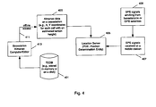
- Figure 4 shows a method to fill in height information for basestation almanac data, which information can be used during navigation processing in a Position Determination Entity (PDE) for altitude aiding, according to one embodiment of the present invention.
- Terrain Elevation DataBase (TEDB) 401 stored according to the present invention e.g., in Random Access Memory (RAM) or a hard disk
- RAM Random Access Memory
- the estimated terrain height for every cell site is maintained on the basestation to provide altitude aiding to location server 405.
- the location server cannot obtain better estimates of the altitude of the mobile station once more accurate estimates of the horizontal position of the mobile station are determined from the times-of-arrive of the SPS signals received at the mobile station.
- FIG. 5 shows a method to organize Digital Elevation Models according to one embodiment of the present invention.
- Area 501 of a Digital Elevation Model is covered by a plurality of rectangular tiles (e.g., tiles 511, 512, 513, and 514).
- area 501 may be the United States, or Korea, or Japan.
- a hierarchy of tiles is used.
- a tile at a lower level has a higher resolution; and a tile at a higher level has a lower resolution.
- a higher level tile has an indicator that indicates whether or not there are lower level tiles that model the same region of the area.
- tile 511 and sub-tiles 521, 522, 523, 524 model the same region of area 501.
- Tile 511 is a higher level tile; tiles 521, 522, 523, and 524 are lower level tiles. If the elevation of a location cannot be determined from a lower level tile, the higher level tile that contains the lower level tile may be used to determine the elevation of the location with less precision.
- Such a hierarchical grid scheme enables a fast search of data.
- the area that contains the location is identified first.
- the high level tile that contains the location is then identified. If there is a lower level tile, the lower level tile that contains the location is accessed.
- the tiles are hashed by coordinates along the latitudinal and the longitudinal directions so that the tile containing a given location can be easily identified from the horizontal coordinates of the location.
- Figure 6 shows an example scheme for numbering tiles. Such a scheme can be used to keep track of lower level tiles within a higher level tile or tiles within an area. Forming a rectangular grid, the tiles are countered in a column-wise or a row-wise fashion to index the tiles so that the index of a tile can be easily determined from its row and column indices. Its row and column indices can also be easily determined from the index of the tile. In the example of Figure 6 , the tiles are countered from the higher left (Northwest) corner of the region in a row-wise fashion. Assuming that the column index of a tile is I, the row index of the tile is J, and the number of columns of the grid is N, the index of the tile is J*N+I.
- Figure 7 shows an example of a profile of terrain elevation.
- the elevations of a plurality of sample points forms a profile.
- An interpolation of the elevations at the sample points provides the elevation for any given point on the line.
- height 703 represents the elevation at point H n
- curve 701 represents an elevation model for the segment between points H 0 and H n .
- Various ID interpolation schemes may be used to generate curve 701.
- Figure 8 shows a method to determining a terrain elevation for a location from a Digital Elevation Model (DEM) according to one embodiment of the present invention.
- a tile of DEM contains a plurality of profiles.
- profiles P 1 , P 2 , P 3 and P 4 in Figure 8 are contained within a single tile of DEM.
- the elevation of a location can be determined from the elevations of the sample points near the location.
- the elevation of point X in Figure 8 can be determined from an interpolation using the elevations at sample points X 1 , X 2 , X 3 , and X 4 .
- a bi-linear interpolation is used to compute the elevation of a point between two profiles and between two lines of sample points (which are in a direction that is not parallel to the lines of profiles).
- a bi-quadratic interpolation scheme is used to determined the elevation of a location using the elevations of the sample points near the location in a tile of Digital Elevation Model.
- the profile data for a tile is typically stored in an area specific coordinate system.
- the horizontal coordinates may be represented in a WGS84 system, or in a NAD83 system, or in a system specific for Japan or Korea; and a vertical coordinate system may be a Mean Sea Level (MSL) system (e.g., NAD88 or NAD27), or a Height Above Ellipsoid (HAE) system.
- MSL Mean Sea Level
- HAE Height Above Ellipsoid
- HAE Height Above Ellipsoid
- a WGS84 system e.g., a WGS84 system, a WGS72 system, a Clarke 1866 system, or a Bessel 1841 system
- ellipsoid models e.g., different semi-major axes and flattening ratios.
- Datum tables can be used to define transformations from various different coordinate systems to one coordinate system (e.g., the coordinate used by a PDE, such as a WGS84 system).
- FIG. 9 shows a Server Elevation Aiding subsystem according to one embodiment of the present invention.
- Server Elevation Aiding subsystem 901 contains interpolator 910, geodetic computer 920, digital elevation model manager 930 and digital elevation model data access manager 940.
- Interpolator 910 contains ID interpolator 911 and 2D interpolator 913 to provide interpolation in 1D and 2D.
- the 2D interpolator can perform a bi-linear interpolation, which is used by NGS (National Geodetic Survey) and NIMA (National Imaging and Mapping Agency) for interpolation various grids of data.
- the 2D interpolator can also perform bi-quadratic interpolation to compute the elevation of a location from the elevations of the sample points near the location.
- Geodetic computer 920 contains datum transformation manager 921 and map projector 923. Geodetic computer 920 is used to perform transformation of coordinates of a location between one coordinate system (e.g., a system used by a location server), and another coordinate system (e.g., a system used by a DEM tile).
- the common analytic transformation method of Molodensky can be used for the datum transformation for Japan; a NADCON interpolation based method can be used to transform USA NAD27 DEM data.
- the horizontal coordinate system for the DEM tile is a WGS72 system, the Molodensky or a 7 parameter S-transformation may be used to perform the transformation.
- Geodetic computer 920 may also use other transformations, such as 3D similarity transformation (aka Bursa-Wolf transformation).
- DEM manager 930 contains tile area 931, which further contains tiles of DEM (933).
- the tiles of DEM contain elevation data, stored in RAM, or in Memory Mapped Files (MMF), or files on a disk drive (e.g., a hard disk, a CD-ROM, a DVD-ROM, etc.).
- MMF Memory Mapped Files
- a DEM manager is used to store and manage the hierarchical list of tiles.
- DEM data access manager 940 contains decoder 941 and encoder 943 to provide access to tiles for various storage mechanism (e.g., hard disk or memory).
- Encoder 943 can transform a DEM model from a flat file to an indexed and compressed TEDB using a method describe below.
- Decoder 941 can decode a DEM model encoded in an indexed and compressed TEDB in order to access the elevation data in the database.
- FIG 10 shows a data representation of a tile of a Digital Elevation Model (DEM) according to one embodiment of the present invention.
- the data for various profiles in a tile is compressed using a scheme described below.
- a tile header 1001 is used to specify the common data (meta data) for the tile, which is necessary for interpreting the DEM in the tile.
- Indices 1011 - 1019 are stored after tile header 1001 to indicating the locations of the starting points of the data for various profiles. For example, index 1012 points to header 1022 for profile 1, which contains meta data specific for interpreting compressed elevation data 1032 for profile 1. Similarly, index 1019 points to header 1029 for profile n.
- compressed elevation data for various profiles requires storage spaces of different sizes. From the horizontal coordinates of a given location, the profiles that contains sample points near the location can be determined from the tile header. The indices for these profiles can be access to determine the location of the profile headers and the compressed elevation data for these profiles. The indices of the sample points near the location in the profiles can be determined from the tile header (and, in some embodiments, the profile headers).
- Figure 11 shows a data representation of a header for storing a portion of a Digital Elevation Model (DEM) according to one embodiment of the present invention.
- Data 1101 contains the type of the record and the length of the header. The type of the record indicates whether the header is a profile header or a tile header.
- Item 1103 contains indicators showing the type of data contained in this tile, which may be DEM, Geoid, latitude or longitude datum translations.
- Horizontal coordinate system 1105 specifies the coordinate system used to represent the horizontal positions of the sample points, which can be a geographic system, a UTM system, etc.
- Vertical coordinate system 1107 specifies the coordinate system used to represent the elevations of the sample points, which can be Local SL, MSL, or HAE, etc.
- Units 1190 specify the units used in measuring the horizontal coordinates and the elevations.
- Profile ordering 1111 specifies the direction of profile lines (e.g., along longitudinal direction or along latitudinal direction), and numbers of sample points along both directions in a tile. Corner points 1113 specify the positions of the corner points of the tile.
- Reference point 1115 specifies the reference value for elevations, and the latitude and longitude of starting points for profiles.
- Tile size 1117 specifies the size of the tile in the latitudinal direction and in the longitudinal direction.
- Subtile specification 1119 indicates the size of the sub-tiles under the tile, if exist.
- Compression parameters 1121 include the scaling factor used in encoding the elevation data and an indicator showing whether or not the elevations data is run length encoded. Details about the scaling factor and run length encoding are described below.
- Tile headers and profile headers may have different formats; a tile header may have more or less data items than that shown in Figure 11 ; and a profile header may have more or less data items than that shown in Figure 11 .
- a tile header may further include a string showing the source of the DEM (e.g., from a USGS model or from an NGS model) or byte ordering information; meanwhile, a profile header may not have items 1105 and 1107 for specifying the coordinate systems, since all the profiles within a tile used the same coordinate system.
- Figure 12 shows a Run Length Encoding scheme which can be used with the present invention.
- a string of symbols e.g., numbers representing elevations
- a run is a continuous repetitive string of a particular symbol.
- a sequence is a continuous non-repetitive string of symbols.
- the string of symbols between symbols 1201 and 1202 is a run; and the string of symbols between symbols 1203 and 1204 is a sequence.
- a run can be encoded as a number indicating the number of repetition of the symbol and the symbol itself.
- the run between the symbols 1201 and 1202 is encoded as number 1211, which is equal to the number of repetition subtracted from one, and symbol 1212.
- a sequence can be encoded as a number indicating the length of the string of non-repetitive symbols and the string of non-repetitive symbols.
- the sequence between symbols 1203 and 1204 is represented by number 1213, which is equal to one subtracted from the number of symbols between symbols 1203 and 1204, and a copy of the symbols (symbols between 1217 and 1214).
- the run between symbols 1205 and 1206 is encoded as number 1215 and 1216.
- a run is represented by a negative number preceding a symbol; and a sequence is represented by a non-negative number preceding a string of symbols.
- the encoded data between 1211 and 1216 can be decoded to recover the original string of symbols (between 1201 and 1206) in a decoding process.
- Figure 13 illustrates an example of encoding a portion of a Digital Elevation Model (DEM) for storage according to one embodiment of the present invention.
- Column 1303 represents the original elevation data of a DEM profile.
- the sample point on row 1351 contains the minimum of the elevations for this profile.
- Column 1305 represents the normalized elevations, which is obtained from subtracting the minimum value from the original data in column 1303.
- Column 1307 represents the scaled elevations, which is obtained from dividing the normalized elevations in column 1305 by a scaling factor (four).
- the scaling factors are such that the division of integers can be carried out by bit shift operations during the encoding process and the multiplication of integers can be carried out by bit shift operations during the decoding process.
- the range of the scaled elevations may be reduced so that the scaled elevations can be represented by integers that take less storage spaces.
- the original data is represented by 2-byte integers.
- some profiles can be represented by scaled and normalized elevations as 1-byte integers.
- scaled and normalized elevations in column 1307 can be further compressed using a run length encoding scheme.
- scaled elevations between rows 1351 and 1352 can be encoded as a sequence (1311, 1312 and 1313); and those between rows 1353 and 1359 can be encoded as a run (1321 and 1322).
- FIG. 14 shows a method to encode a portion of a Digital Elevation Model (DEM) for storage according to one embodiment of the present invention.
- Operation 1401 loads elevations for a profile of a DEM tile.
- elevation data are read from a flat file (non-indexed) that contains a Digital Elevation Model of an area (e.g., the United States, or the world).
- Such a flat file is large in size.
- operations 1403 - 1411 are used to compress the data and to store the data in one or more indexed files.
- Operation 1403 generates normalized elevations for the profile.
- the elevations of the profile are normalized with respect to a reference value.
- the normalized elevations are generated from subtracting the minimum elevation for the DEM tile from the elevations.
- the elevations are normalized with respect to the minimum elevation of the profile (or mean elevation of the profile).
- Operation 1405 scales the normalized elevations to generate scaled elevations.
- the scaled elevations requires less storage space than the elevations loaded from a flat file, since the range of data is reduced after the normalizing and scaling operations. For example, original elevation data for a profile that is represented by 2-byte integers can be represented by 1-byte scaled elevations.
- Operation 1407 run length encodes the scaled elevations to generate compressed elevation data for the profile.
- Operation 1409 generates an index for accessing the compressed elevation data in an indexed file. The index and the compressed elevation data are stored in the indexed file in operation 1411.
- Operations 1401 - 1411 can be repeated to encode (compress) a plurality of profiles of a DEM tile and to store the compressed elevation data for the profiles of the tile in one indexed file.
- compressed elevation data for different tiles of a Digital Elevation Model are stored in different files.
- One indexed file is used for each of the tiles.
- multiple tiles of compressed elevation data can be stored in one indexed file, where indices for accessing each of the tiles are stored for fast accesses to individual tiles.
- Multiple tiles of a DEM that models a specific geographical area can be organized as an area of a DEM.
- a DEM may have a plurality of areas.
- the elevation data for the tiles of DEM are represented in area specific coordinate systems.
- the tiles from different DEMs are organized in a hierarchy as described above (See Figure 5 ).
- the indexed files store the indicators linking the tiles of different levels in the hierarchy.
- the compressed and indexed elevation data of one or more Digital Elevation Models forms a Terrain Elevation DataBase (TEDB).
- TEDB Terrain Elevation DataBase
- Figure 15 shows a method to compute the elevation of a location according to one embodiment of the present invention.
- operation 1501 receives first horizontal coordinates of a location measured in a first horizontal coordinate system (e.g., a coordinate system used by a Position Determination Entity)
- operation 1503 converts the first horizontal coordinates of the location into second horizontal coordinates of the location measured in a second horizontal coordinate system used by a Terrain Elevation DataBase (TEDB).
- a first horizontal coordinate system e.g., a coordinate system used by a Position Determination Entity
- a typical Position Determination Entity uses a WGS84 system for specifying a horizontal position; and a TEDB typically stores profiles using area specific coordinate systems for various areas, such as a Universal Transverse Mercator (UTM) system, a geographic system (latitude, longitude), a local coordinates system for a region (e.g., a US state plane based system), etc.
- UTM Universal Transverse Mercator
- a conversion in operation 1503 is used to generate coordinates that can be used to search elevation data in the TEDB near the location specified by the first horizontal coordinates.
- Operation 1505 retrieves elevations of a plurality of points near the location from the Terrain Elevation DataBase.
- operation 1507 interpolates the elevations of the plurality of points near the location to compute a first elevation of the location measured in a first vertical coordinate system used by the Terrain Elevation DataBase
- operation 1509 converts the first elevation of the location into a second elevation of the location measured in a second vertical coordinate system (e.g., a coordinate system used by a Position Determination Entity).
- a typical Position Determination Entity uses a Height Above Ellipsoid (HAE) system for specifying an elevation (altitude); and a TEDB typically stores profiles using area specific coordinate systems for various areas, such as a Means Sea Level (MSL) system, a Local Sea Level (Local SL) system, or a Height Above Ellipsoid system.
- MSL Means Sea Level
- Local SL Local Sea Level
- the estimated accuracy (standard error) of the interpolated terrain elevation is also computed in operation 1507.
- Operation 1511 performs altitude aiding using the second elevation of the location.
- the second elevation of the location can be provided to a Position Determination Entity to perform altitude aiding.
- the computation of the second elevation for altitude aiding can be in the form of real time access as illustrated in Figure 3 , or in the form of offline access as illustrated in Figure 4 .
- Various altitude aiding methods such as those described in U.S. Patent No. 6,061,018, can be used with the present invention.
- the area of DEM that contains the location is identified and retrieved in order to retrieve elevations for a plurality of points near the location from the Terrain Elevation DataBase.
- the tile of DEM that contains the location is identified and retrieved. From the header of the tile, the profiles that contain points near the location are identified and accessed. From the headers of the profiles and the header of the tile, the points near the location are identified. After decoding at least portions of the compressed profiles in the Terrain Elevation DataBase, the elevations of the plurality of points near the location can be retrieved.
- Figure 16 shows one method to decode a portion of a Digital Elevation Model (DEM) for computing the elevation of a location according to one embodiment of the present invention.
- Operation 1601 obtains an index for accessing compressed elevation data for a profile in a DEM tile.
- the DEM tile may be stored in a Memory Mapped File (MMF), or in RAM, or in a file on a file system of a digital processing system (e.g., on a hard drive, a CD-ROM, or a network file), etc.
- MMF Memory Mapped File
- index 1019 for profile n is obtained in order to access the compressed data 1039 for profile n.
- Operation 1602 identifies the points that are near the location in the profile.
- the index is used to retrieve the profile header, from which the indices of the sample points in the profile, which are near the location, are computed.
- the indices of the sample points near the location are computed using the information in the tile header.
- computing the indices of the sample points near the location may involve both the tile header and the profile headers.
- operation 1605 run length decodes the compressed elevation data to generate scaled elevations for the points near the location. In general, it is necessary to run length decode a portion of a compressed profile to obtain the scaled elevations for the points near the location.
- Operation 1607 inverse scales the scaled elevations to generate normalized elevations.
- Operation 1609 de-normalizes the normalized elevations to recover the elevations for the points near the location. The reference elevation that is subtracted from the original elevation data in the decoding process is added back to the normalized elevations to reproduce the elevations of the points near the location.
- Operation 1610 computes the elevation of the location from an interpolation using the elevations of the points near the location.
- operations 1601 - 1609 are repeated for a plurality of profiles near the location to obtain elevations of a plurality of points in the plurality of profiles before operation 1610 is performed to compute the elevation of the location; and, a bi-quadratic interpolation is used to compute the elevation of the location.
- Terrain Elevation DataBases store the elevation data in a compressed and indexed format, less storage space is required.
- the compressed elevation data from a high resolution Digital Elevation Model can be stored in storage media with faster access speeds (e.g., RAM or memory mapped file) for real time altitude aiding in the process of position determination in wireless assisted hybrid positioning system.
- each of profiles contains elevation data for sample points on a single scan line
- the present invention can also be applied when each of the profiles contains elevation data for sample points on a plurality of scan lines.
Landscapes
- Engineering & Computer Science (AREA)
- Radar, Positioning & Navigation (AREA)
- Remote Sensing (AREA)
- General Physics & Mathematics (AREA)
- Physics & Mathematics (AREA)
- Automation & Control Theory (AREA)
- Computer Networks & Wireless Communication (AREA)
- Theoretical Computer Science (AREA)
- Signal Processing (AREA)
- Position Fixing By Use Of Radio Waves (AREA)
- Radar Systems Or Details Thereof (AREA)
- Processing Or Creating Images (AREA)
- Instructional Devices (AREA)
- Control Of Position, Course, Altitude, Or Attitude Of Moving Bodies (AREA)
- Aiming, Guidance, Guns With A Light Source, Armor, Camouflage, And Targets (AREA)
- Signal Processing For Digital Recording And Reproducing (AREA)
- Compression, Expansion, Code Conversion, And Decoders (AREA)
- Mobile Radio Communication Systems (AREA)
- Information Retrieval, Db Structures And Fs Structures Therefor (AREA)
Abstract
Description
- The invention relates to wireless assisted hybrid positioning systems, and more particularly to storage and retrieval of digital terrain model elevations.
- To perform position location in wireless cellular networks (e.g., a cellular telephone network), several approaches perform triangulation based upon the use of timing information sent between each of several basestations and a mobile device, such as a cellular telephone. One approach, called Advanced Forward Link Trilateration (AFLT) or Enhanced Observed Time Difference (EOTD), measures at the mobile device the times of arrival of signals transmitted from each of several basestations. These times are transmitted to a Position Determination Entity (PDE) (e.g., a location server), which computes the position of the mobile device using these times of reception. The times-of-day at these basestations are coordinated such that at a particular instance of time, the times-of-day associated with multiple basestations are within a specified error bound. The accurate positions of the basestations and the times of reception are used to determining the position of the mobile device.
- Figure 1 shows an example of an AFLT system where the times of reception (TR1, TR2, and TR3) of signals from
cellular basestations cellular telephone 111. This timing data may then be used to compute the position of the mobile device. Such computation may be done at the mobile device itself, or at a location server if the timing information so obtained by the mobile device is transmitted to the location server via a communication link. Typically, the times of receptions are communicated to alocation server 115 through of one the cellular basestations (e.g.,basestation location server 115 is coupled to receive data from the basestations through themobile switching center 113. Themobile switching center 113 provides signals (e.g., voice communications) to and from the land-line Public Switched Telephone System (PSTS) so that signals may be conveyed to and from the mobile telephone to other telephones (e.g., land-line phones on the PSTS or other mobile telephones). In some cases the location server may also communicate with the mobile switching center via a cellular link. The location server may also monitor emissions from several of the basestations in an effort to determine the relative timing of these emissions. - In another approach, called Time Difference of Arrival (TDOA), the times of reception of a signal from a mobile device is measured at several basestations. Figure 1 applies to this case if the arrows of TR1, TR2, and TR3 are reversed. This timing data may then be communicated to the location server to compute the position of the mobile device.
- Yet a third method of doing position location involves the use in the mobile device of a receiver for the United States Global Positioning Satellite (GPS) system or other Satellite Positioning System (SPS), such as the Russian Glonass system and the proposed European Galileo System, or a combination of satellites and pseudolites. Pseudolites are ground-based transmitters, which broadcast a PN code (similar to a GPS signal) modulated on an L-band carrier signal, generally synchronized with SPS time. Each transmitter may be assigned a unique PN code so as to permit identification by a remote receiver. Pseudolites are useful in situations where SPS signals from an orbiting satellite might be unavailable, such as tunnels, mines, buildings or other enclosed areas. The term "satellite", as used herein, is intended to include pseudolite or equivalents of pseudolites, and the term GPS signals, as used herein, is intended to include GPS-like signals from pseudolites or equivalents of pseudolites. Such a method using a receiver for SPS signals may be completely autonomous or may utilize the cellular network to provide assistance data or to share in the position calculation. Examples of such a method are described in U.S. Patents No. 5,841,396; No. 5,945,944; and No. 5,812,087. As a shorthand, we call these various methods "SPS". In practical low-cost implementations, both the mobile cellular communications receiver and the SPS receiver are integrated into the same enclosure and, may in fact share common electronic circuitry.
- A combination of either the AFLT or TDOA with an SPS system is called a "hybrid" system.
- In yet another variation of the above methods, the round trip delay (RTD) is found for signals that are sent from the basestation to the mobile device and then are returned. In a similar, but alternative, method the round trip delay is found for signals that are sent from the mobile device to the basestation and then returned. Each of these round-trip delays is divided by two to determine an estimate of the one-way time delay. Knowledge of the location of the basestation, plus a one-way delay constrains the location of the mobile device to a circle on the earth. Two such measurements then result in the intersection of two circles, which in turn constrains the location to two points on the earth. A third measurement (even an angle of arrival or cell sector) resolves the ambiguity.
- Altitude aiding has been used in various methods for determining the position of a mobile device. Altitude aiding is typically based on a pseudomeasurement of the altitude. The knowledge of the altitude of a location of a mobile device constrains the possible positions of the mobile device to a surface of a sphere (or an ellipsoid) with its center located at the center of the earth. This knowledge may be used to reduce the number of independent measurements required to determine the position of the mobile device. Typically, an estimated altitude can be manually supplied by the operator of the mobile device, or be set to an altitude from a previous three-dimensional solution, or be set to a predetermined value, or be derived from mapping information, such as a topographical or geodetic database, maintained at a location server.
- U.S. Patent No. 6,061,018, which is hereby incorporated here by reference, describes a method where an estimated altitude is determined from the information of a cell object, which may be a cell site that has a cell site transmitter in communication with the mobile device. U.S. Patent No. 6,061,018 also describes a method of determining the condition of the measurements of the pseudoranges from a plurality of SPS satellites by comparing an altitude calculated from the pseudorange measurements with the estimated altitude.
- Sometimes a table of lower resolution altitude data is stored in memory. Typically, high-resolution mapping information, such as a topographical or geodetic database, is stored in one or more flat files (non-indexed) at a location server. For example, a global Digital Elevation Model (DEM) with a horizontal grid spacing of 30 arc seconds (approximately 1 kilometer) may be obtained from U.S. Geological Survey on a set of five CD-ROMs. A DEM file from U.S. Geological Survey (http://edcdaac.usgs.gov/) is provided as 16-bit signed integers in a simple generic binary raster format. There is limited header and sometimes trailer bytes embedded in the image data. The data are stored in row major order (all the data for
row 1, followed by all the data forrow 2, etc.). - Sometimes, a Digital Elevation Model (DEM) is also referred to as a Digital Terrain Model (DTM).
- Methods and apparatuses to generate and to access compressed and indexed elevations of Digital Elevation Models are described here.
- In one aspect of the invention, a method to store elevation data includes: compressing elevation data of a first portion of a Digital Elevation Model (DEM) to generate first compressed elevation data; storing the first compressed elevation data in a storage location pointed to by a first index; and storing the first index. In one example according to this aspect, the elevation data of the first portion is compressed by: subtracting a reference elevation from the elevation data of the first portion of the Digital Elevation Model (DEM) to generate normalized elevation data; scaling the normalized elevation data to generate scaled elevation data; and run length encoding the scaled elevation data to generate the first compressed elevation data. In one example, the parameters required for determining whether or not a location is in the first portion of the Digital Elevation Model, as well as the transformation data specifying a coordinate system used to represent the elevation data of the first portion of the Digital Elevation Model, are also stored. In one example, a Digital Elevation Model is divided into a plurality of areas; an area of the Digital Elevation Model is divided into a plurality of tiles; and the profiles in each of the plurality of tiles of an area of the Digital Elevation Model are individually compressed. Parameters required for determining whether or not a location is in one of the plurality of tiles, as well as the parameters required for determining whether or not a location is in one of the plurality of areas, are also stored.
- In another aspect of the invention, a method to retrieve elevation data includes: locating a first compressed portion of a Digital Elevation Model (DEM) using a first index; and decompressing the first compressed portion to retrieve first elevation data for at least one sample point in the Digital Elevation Model. The Digital Elevation Model has a plurality of compressed portions which includes the first compressed portion; and the first index points to a storage location where the first compressed portion is stored.
- In one example according to this aspect, the first compressed portion is decompressed by: run length decoding the first compressed portion to generate scaled elevation data; inverse scaling the scaled elevation data to generate normalized elevation data; and adding a reference elevation to the normalized elevation data to generate the first elevation data. In one example according to this aspect, the plurality of compressed portions are stored in one of: a) a Memory Mapped File (MMF); b) Random Access Memory (RAM); and c) a file in a file system on a digital processing system; and the plurality of compressed portions are portions of compressed profiles in a tile of the Digital Elevation Model.
- In one example, to compute an elevation of a location, an area in a plurality of areas of a Digital Elevation Model is identified; a tile that contains the location is identified from a plurality of tiles in the area; a profile that is in the vicinity of the location is identified; and at least a portion of the profile is decompressed to retrieve elevation data of at least one sample point. A plurality of sample points in the vicinity of the location are identified. After the elevations of the plurality of sample points are retrieved from the Digital Elevation Model, the elevation of the location is computed from an interpolation using the elevations of the plurality of sample points. A coordinate transformation is performed to express a horizontal position of the location in a coordinate system used by the Digital Elevation Model. In computing the elevation of the location, a coordinate transformation is performed so that the elevation of location is expressed in a coordinate system used by a Position Determination Entity. The elevation of the location is provided to the Position Determination Entity to perform altitude aiding in a positioning system. The elevation is provided in real time in response to a request from a Position Determination Entity in one scenario; and the elevation is provided to fill in information for basestation almanac data, which is subsequently used by a Position Determination Entity for altitude aiding, in another scenario.
- The present invention includes apparatuses which perform these methods, including data processing systems which perform these methods and computer readable media which when executed on data processing systems cause the systems to perform these methods.
- Other features of the present invention will be apparent from the accompanying drawings and from the detailed description which follow.
- The present invention is illustrated by way of example and not limitation in the figures of the accompanying drawings in which like references indicate similar elements.
- Figure 1 shows an example of a prior art cellular network which determines the position of a mobile cellular device.
- Figure 2 shows an example of a location server which may be used with the present invention.
- Figure 3 shows a method to use a Terrain Elevation DataBase (TEDB) to provide terrain height information in real time during navigation processing in a Position Determination Entity (PDE) according to one embodiment of the present invention.
- Figure 4 shows a method to fill in height information for basestation almanac data, which information can be used during navigation processing in a Position Determination Entity (PDE) for altitude aiding, according to one embodiment of the present invention.
- Figure 5 shows a method to organize Digital Elevation Models according to one embodiment of the present invention.
- Figure 6 shows an example scheme for numbering tiles in an area.
- Figure 7 shows an example of a profile of terrain elevation data.
- Figure 8 shows a method to determining a terrain elevation for a location from a Digital Elevation Model (DEM) according to one embodiment of the present invention.
- Figure 9 shows a Server Elevation Aiding subsystem according to one embodiment of the present invention.
- Figure 10 shows a data representation of a tile of a Digital Elevation Model (DEM) according to one embodiment of the present invention.
- Figure 11 shows a data representation of a header for storing a portion of a Digital Elevation Model (DEM) according to one embodiment of the present invention.
- Figure 12 shows a Run Length Encoding scheme which can be used with the present invention.
- Figure 13 illustrates an example of encoding a portion of a Digital Elevation Model (DEM) for storage according to one embodiment of the present invention.
- Figure 14 shows a method to encode a portion of a Digital Elevation Model (DEM) for storage according to one embodiment of the present invention.
- Figure 15 shows a method to compute the elevation of a location according to one embodiment of the present invention.
- Figure 16 shows one method to retrieve and decode a portion of a Digital Elevation Model (DEM) for computing the elevation of a location according to one embodiment of the present invention.
- The following description and drawings are illustrative of the invention and are not to be construed as limiting the invention. Numerous specific details are described to provide a thorough understanding of the present invention. However, in certain instances, well known or conventional details are not described in order to avoid obscuring the description of the present invention.
- At least one embodiment of the present invention seeks to efficiently store terrain elevation data in a database and to efficiently use the terrain elevation data in the database to provide an estimated altitude for a location.
- Figure 2 shows an example of a data processing system which may be used as a server in various embodiments of the present invention. For example, as described in U.S. Patent No. 5,841,396, the server may provide assistance data such as Doppler or other satellite assistance data to the GPS receiver in a mobile station. In addition, or alternatively, the location server may perform the final position calculation rather than the mobile station (after receiving pseudoranges or other data from which pseudoranges can be determined from the mobile station) and then may forward this position determination to the basestation or to some other system. The data processing system as a location server typically includes
communication devices 212, such as modems or network interface. The location server may be coupled to a number of different networks through communication devices 212 (e.g., modems or other network interfaces). Such networks include the cellular switching center or multiple cellular switching centers 225, the land based phone system switches 223, cellular basestations, otherGPS signal sources 227, or other processors ofother location servers 221. - Multiple cellular basestations are typically arranged to cover a geographical area with radio coverage, and these different basestations are coupled to at least one mobile switching center, as is well known in the prior art (e.g., see Figure 1). Thus, multiple basestations would be geographically distributed but coupled together by a mobile switching center. The
network 220 may be connected to a network of reference GPS receivers which provide differential GPS information and may also provide GPS ephemeris data for use in calculating the position of mobile systems. The network is coupled through the modem or other communication interface to theprocessor 203. Thenetwork 220 may be connected to other computers or network components. Also network 220 may be connected to computer systems operated by emergency operators, such as the Public Safety Answering Points which respond to 911 telephone calls. Various examples of methods for using a location server have been described in numerous U.S. patents, including: U.S. Patents No. 5,841,396; No. 5,874,914; No. 5,812,087; and No. 6,215,442, all of which are hereby incorporated here by reference. - The
location server 201, which is a form of a data processing system, includes abus 202 which is coupled to amicroprocessor 203 and aROM 207 andvolatile RAM 205 and anon-volatile memory 206. Theprocessor 203 is coupled tocache memory 204 as shown in the example of Figure 2. Thebus 202 interconnects these various components together. While Figure 2 shows that the non-volatile memory is a local device coupled directly to the rest of the components in the data processing system, it will be appreciated that the present invention may utilize a non-volatile memory which is remote from the system, such as a network storage device which is coupled to the data processing system through a network interface such as a modem or Ethernet interface. Thebus 202 may include one or more buses connected to each other through various bridges, controllers and/or adapters as is well known in the art. In many situations the location server may perform its operations automatically without human assistance. In some designs where human interaction is required, the I/O controller 209 may communicate with displays, keyboards, and other I/O devices. - Note that while Figure 2 illustrates various components of a data processing system, it is not intended to represent any particular architecture or manner of interconnecting the components as such details are not germane to the present invention. It will also be appreciated that network computers and other data processing systems which have fewer components or perhaps more components may also be used with the present invention and may act as a location server or a PDE.
- It will be apparent from this description that aspects of the present invention may be embodied, at least in part, in software. That is, the techniques may be carried out in a computer system or other data processing system in response to its processor executing sequences of instructions contained in memory, such as
ROM 207,volatile RAM 205,non-volatile memory 206,cache 204 or a remote storage device. In various embodiments, hardwired circuitry may be used in combination with software instructions to implement the present invention. Thus, the techniques are not limited to any specific combination of hardware circuitry and software nor to any particular source for the instructions executed by the data processing system. In addition, throughout this description, various functions and operations are described as being performed by or caused by software code to simplify description. However, those skilled in the art will recognize what is meant by such expressions is that the functions result from execution of the code by a processor, such as theprocessor 203. - In some embodiments the methods of the present invention may be performed on computer systems which are simultaneously used for other functions, such as cellular switching, messaging services, etc. In these cases, some or all of the hardware of Figure 2 would be shared for several functions.
- While storing or retrieving terrain elevation data from a database can be performed on a location server, these operations may also be performed on other digital processing systems similar to that illustrated in Figure 2.
- Figure 3 shows a method to use a Terrain Elevation DataBase (TEDB) to provide terrain height information in real time during navigation processing in a Position Determination Entity (PDE) according to one embodiment of the present invention. Terrain Elevation DataBase (TEDB) 301 stored according to the present invention (e.g., in Random Access Memory (RAM) or a hard disk) provides real time access on
line 311 to alocation server 305 for altitude aiding.Location server 305 can efficiently retrieve an altitude for any given location in the process of determining a location of a mobile station. - In one example,
almanac data 303 on a basestation provides an estimated horizontal position of the cell site to the location server, which may be used to obtain an initial estimate of the altitude of the mobile station. - SPS signals 309 emitting from basestations or GPS satellites (or other types of SPS satellites) are received at a mobile station. SPS signal 307 received at a mobile station is used to determine the times-of-arrival of the SPS signals emitting from the basestations or SPS satellites.
Location server 305 uses the times-of-arrivals to determine the position of the mobile station. - In the process of iteratively determining the position of the mobile station, better estimations of the altitude of the mobile station can be retrieved from
TEDB 301, whenlocation server 305 determines more accurate horizontal coordinates of the mobile station from the times-of-arrival (or pseudoranges). - In another example, the horizontal position determined from the times-of-arrival can be used to retrieve an estimated altitude of the mobile station from the TEDB in order to determine the condition of the time-of-arrival (or pseudorange) measurements using the methods described in U.S. Patent No. 6,061,018.
- While Figure 3 illustrates an example where the times-of-arrival are measured at a mobile station, such as in an AFLT system, an SPS system, or a hybrid AFLT system, it would be appreciated that such real time access to a TEDB can also be used in other positioning systems where the times-of-arrival are measured at basestations, such as in an TDOA system where times-of-arrival of a signal from a mobile station are determined at a plurality of basestations.
- Figure 4 shows a method to fill in height information for basestation almanac data, which information can be used during navigation processing in a Position Determination Entity (PDE) for altitude aiding, according to one embodiment of the present invention. Terrain Elevation DataBase (TEDB) 401 stored according to the present invention (e.g., in Random Access Memory (RAM) or a hard disk) provides offline access on
line 411 to fill in altitude information in almanac data maintained on a basestation. In one example, a software module, called Basestation Almanac Computer/Editor (413), is used to compute the estimated terrain height for every cell sites listed in the almanac data maintained on the basestation. The estimated terrain height for every cell site is maintained on the basestation to provide altitude aiding tolocation server 405. However, when the offline accessing approach is used, the location server cannot obtain better estimates of the altitude of the mobile station once more accurate estimates of the horizontal position of the mobile station are determined from the times-of-arrive of the SPS signals received at the mobile station. - Figure 5 shows a method to organize Digital Elevation Models according to one embodiment of the present invention.
Area 501 of a Digital Elevation Model is covered by a plurality of rectangular tiles (e.g.,tiles area 501 may be the United States, or Korea, or Japan. When Digital Elevation Models of different resolutions are available for a certain region, a hierarchy of tiles is used. A tile at a lower level has a higher resolution; and a tile at a higher level has a lower resolution. A higher level tile has an indicator that indicates whether or not there are lower level tiles that model the same region of the area. For example,tile 511 andsub-tiles area 501.Tile 511 is a higher level tile;tiles - Such a hierarchical grid scheme enables a fast search of data. The area that contains the location is identified first. The high level tile that contains the location is then identified. If there is a lower level tile, the lower level tile that contains the location is accessed. The tiles are hashed by coordinates along the latitudinal and the longitudinal directions so that the tile containing a given location can be easily identified from the horizontal coordinates of the location.
- Figure 6 shows an example scheme for numbering tiles. Such a scheme can be used to keep track of lower level tiles within a higher level tile or tiles within an area. Forming a rectangular grid, the tiles are countered in a column-wise or a row-wise fashion to index the tiles so that the index of a tile can be easily determined from its row and column indices. Its row and column indices can also be easily determined from the index of the tile. In the example of Figure 6, the tiles are countered from the higher left (Northwest) corner of the region in a row-wise fashion. Assuming that the column index of a tile is I, the row index of the tile is J, and the number of columns of the grid is N, the index of the tile is J*N+I. Assuming the index of the tile is M, the
column index 1= mod(M, N); and the row index J= (M-I)/N. Since the column index and row index of the tile that contains a given location can be computed from the horizontal coordinates of the location and the position of the grid, the tile that contains the location can be easily identified. - Figure 7 shows an example of a profile of terrain elevation. Along a latitudinal (or longitudinal) scan line in a tile of Digital Elevation Model, the elevations of a plurality of sample points forms a profile. An interpolation of the elevations at the sample points provides the elevation for any given point on the line. For example,
height 703 represents the elevation at point Hn; andcurve 701 represents an elevation model for the segment between points H0 and Hn. Various ID interpolation schemes may be used to generatecurve 701. - Figure 8 shows a method to determining a terrain elevation for a location from a Digital Elevation Model (DEM) according to one embodiment of the present invention. A tile of DEM contains a plurality of profiles. For example, profiles P1, P2, P3 and P4 in Figure 8 are contained within a single tile of DEM. The elevation of a location can be determined from the elevations of the sample points near the location. For example, the elevation of point X in Figure 8 can be determined from an interpolation using the elevations at sample points X1, X2, X3, and X4. In the example of Figure 8, a bi-linear interpolation is used to compute the elevation of a point between two profiles and between two lines of sample points (which are in a direction that is not parallel to the lines of profiles). In one embodiment of the present invention, a bi-quadratic interpolation scheme is used to determined the elevation of a location using the elevations of the sample points near the location in a tile of Digital Elevation Model.
- The profile data for a tile is typically stored in an area specific coordinate system. For example, the horizontal coordinates may be represented in a WGS84 system, or in a NAD83 system, or in a system specific for Japan or Korea; and a vertical coordinate system may be a Mean Sea Level (MSL) system (e.g., NAD88 or NAD27), or a Height Above Ellipsoid (HAE) system. Note that different HAE systems (e.g., a WGS84 system, a WGS72 system, a Clarke 1866 system, or a Bessel 1841 system) may use different ellipsoid models (e.g., different semi-major axes and flattening ratios). Datum tables can be used to define transformations from various different coordinate systems to one coordinate system (e.g., the coordinate used by a PDE, such as a WGS84 system).
- Figure 9 shows a Server Elevation Aiding subsystem according to one embodiment of the present invention. Server
Elevation Aiding subsystem 901 containsinterpolator 910,geodetic computer 920, digitalelevation model manager 930 and digital elevation modeldata access manager 940. -
Interpolator 910 containsID interpolator 2D interpolator 913 to provide interpolation in 1D and 2D. In one embodiment of the present invention, the 2D interpolator can perform a bi-linear interpolation, which is used by NGS (National Geodetic Survey) and NIMA (National Imaging and Mapping Agency) for interpolation various grids of data. In another embodiment of the present invention, the 2D interpolator can also perform bi-quadratic interpolation to compute the elevation of a location from the elevations of the sample points near the location. -
Geodetic computer 920 containsdatum transformation manager 921 andmap projector 923.Geodetic computer 920 is used to perform transformation of coordinates of a location between one coordinate system (e.g., a system used by a location server), and another coordinate system (e.g., a system used by a DEM tile). The common analytic transformation method of Molodensky can be used for the datum transformation for Japan; a NADCON interpolation based method can be used to transform USA NAD27 DEM data. When the horizontal coordinate system for the DEM tile is a WGS72 system, the Molodensky or a 7 parameter S-transformation may be used to perform the transformation.Geodetic computer 920 may also use other transformations, such as 3D similarity transformation (aka Bursa-Wolf transformation). -
DEM manager 930 containstile area 931, which further contains tiles of DEM (933). The tiles of DEM contain elevation data, stored in RAM, or in Memory Mapped Files (MMF), or files on a disk drive (e.g., a hard disk, a CD-ROM, a DVD-ROM, etc.). A DEM manager is used to store and manage the hierarchical list of tiles. - DEM
data access manager 940 containsdecoder 941 andencoder 943 to provide access to tiles for various storage mechanism (e.g., hard disk or memory).Encoder 943 can transform a DEM model from a flat file to an indexed and compressed TEDB using a method describe below.Decoder 941 can decode a DEM model encoded in an indexed and compressed TEDB in order to access the elevation data in the database. - Figure 10 shows a data representation of a tile of a Digital Elevation Model (DEM) according to one embodiment of the present invention. According to one embodiment of the present invention, the data for various profiles in a tile is compressed using a scheme described below. To store the profiles in a tile in a storage space shown in Figure 10, a
tile header 1001 is used to specify the common data (meta data) for the tile, which is necessary for interpreting the DEM in the tile. Indices 1011 - 1019 are stored aftertile header 1001 to indicating the locations of the starting points of the data for various profiles. For example,index 1012 points toheader 1022 forprofile 1, which contains meta data specific for interpretingcompressed elevation data 1032 forprofile 1. Similarly,index 1019 points toheader 1029 for profile n. In general, compressed elevation data for various profiles requires storage spaces of different sizes. From the horizontal coordinates of a given location, the profiles that contains sample points near the location can be determined from the tile header. The indices for these profiles can be access to determine the location of the profile headers and the compressed elevation data for these profiles. The indices of the sample points near the location in the profiles can be determined from the tile header (and, in some embodiments, the profile headers). - Figure 11 shows a data representation of a header for storing a portion of a Digital Elevation Model (DEM) according to one embodiment of the present invention.
Data 1101 contains the type of the record and the length of the header. The type of the record indicates whether the header is a profile header or a tile header.Item 1103 contains indicators showing the type of data contained in this tile, which may be DEM, Geoid, latitude or longitude datum translations. Horizontal coordinatesystem 1105 specifies the coordinate system used to represent the horizontal positions of the sample points, which can be a geographic system, a UTM system, etc. Vertical coordinatesystem 1107 specifies the coordinate system used to represent the elevations of the sample points, which can be Local SL, MSL, or HAE, etc. Units 1190 specify the units used in measuring the horizontal coordinates and the elevations. Profile ordering 1111 specifies the direction of profile lines (e.g., along longitudinal direction or along latitudinal direction), and numbers of sample points along both directions in a tile. Corner points 1113 specify the positions of the corner points of the tile.Reference point 1115 specifies the reference value for elevations, and the latitude and longitude of starting points for profiles.Tile size 1117 specifies the size of the tile in the latitudinal direction and in the longitudinal direction.Subtile specification 1119 indicates the size of the sub-tiles under the tile, if exist.Compression parameters 1121 include the scaling factor used in encoding the elevation data and an indicator showing whether or not the elevations data is run length encoded. Details about the scaling factor and run length encoding are described below. - From the above description, it would be apparent to one skilled in the art that various data representation of headers may be used for tile headers or profile headers. Tile headers and profile headers may have different formats; a tile header may have more or less data items than that shown in Figure 11; and a profile header may have more or less data items than that shown in Figure 11. For example, a tile header may further include a string showing the source of the DEM (e.g., from a USGS model or from an NGS model) or byte ordering information; meanwhile, a profile header may not have
items - Figure 12 shows a Run Length Encoding scheme which can be used with the present invention. A string of symbols (e.g., numbers representing elevations) can be segmented as runs and sequences. A run is a continuous repetitive string of a particular symbol. A sequence is a continuous non-repetitive string of symbols. For example, the string of symbols between
symbols symbols symbols number 1211, which is equal to the number of repetition subtracted from one, andsymbol 1212. Similarly, a sequence can be encoded as a number indicating the length of the string of non-repetitive symbols and the string of non-repetitive symbols. For example, the sequence betweensymbols number 1213, which is equal to one subtracted from the number of symbols betweensymbols symbols number - Figure 13 illustrates an example of encoding a portion of a Digital Elevation Model (DEM) for storage according to one embodiment of the present invention.
Column 1303 represents the original elevation data of a DEM profile. The sample point onrow 1351 contains the minimum of the elevations for this profile.Column 1305 represents the normalized elevations, which is obtained from subtracting the minimum value from the original data incolumn 1303.Column 1307 represents the scaled elevations, which is obtained from dividing the normalized elevations incolumn 1305 by a scaling factor (four). In one embodiment of the present invention, the scaling factors are such that the division of integers can be carried out by bit shift operations during the encoding process and the multiplication of integers can be carried out by bit shift operations during the decoding process. In one embodiment of the present invention, when the elevations are measured in the unit of meter, the maximum scaling factor is 4 (i.e., the Least Significant Bit (LSB) of a scaled elevation represents 4 meters); when the elevations are measured in the unit of foot, the maximum scaling factor is 16 (i.e., LSB= 16 feet). After the normalization and scaling process, the range of the scaled elevations may be reduced so that the scaled elevations can be represented by integers that take less storage spaces. In one embodiment of the present invention, the original data is represented by 2-byte integers. After the normalization and scaling process, some profiles can be represented by scaled and normalized elevations as 1-byte integers. The scaled and normalized elevations incolumn 1307 can be further compressed using a run length encoding scheme. For example, scaled elevations betweenrows rows - Figure 14 shows a method to encode a portion of a Digital Elevation Model (DEM) for storage according to one embodiment of the present invention.
Operation 1401 loads elevations for a profile of a DEM tile. Typically, elevation data are read from a flat file (non-indexed) that contains a Digital Elevation Model of an area (e.g., the United States, or the world). Such a flat file is large in size. To efficiently store and access the Digital Elevation Model, operations 1403 - 1411 are used to compress the data and to store the data in one or more indexed files.Operation 1403 generates normalized elevations for the profile. The elevations of the profile are normalized with respect to a reference value. In one embodiment of the present invention, the normalized elevations are generated from subtracting the minimum elevation for the DEM tile from the elevations. In another embodiment, the elevations are normalized with respect to the minimum elevation of the profile (or mean elevation of the profile).Operation 1405 scales the normalized elevations to generate scaled elevations. In one embodiment of the present invention, the scaled elevations requires less storage space than the elevations loaded from a flat file, since the range of data is reduced after the normalizing and scaling operations. For example, original elevation data for a profile that is represented by 2-byte integers can be represented by 1-byte scaled elevations.Operation 1407 run length encodes the scaled elevations to generate compressed elevation data for the profile.Operation 1409 generates an index for accessing the compressed elevation data in an indexed file. The index and the compressed elevation data are stored in the indexed file inoperation 1411. - Operations 1401 - 1411 can be repeated to encode (compress) a plurality of profiles of a DEM tile and to store the compressed elevation data for the profiles of the tile in one indexed file. In one embodiment, compressed elevation data for different tiles of a Digital Elevation Model are stored in different files. One indexed file is used for each of the tiles. Alternatively, multiple tiles of compressed elevation data can be stored in one indexed file, where indices for accessing each of the tiles are stored for fast accesses to individual tiles. Multiple tiles of a DEM that models a specific geographical area can be organized as an area of a DEM. A DEM may have a plurality of areas. Typically, the elevation data for the tiles of DEM are represented in area specific coordinate systems.
- When multiple DEMs of different resolutions are available, the tiles from different DEMs are organized in a hierarchy as described above (See Figure 5). The indexed files store the indicators linking the tiles of different levels in the hierarchy.
- The compressed and indexed elevation data of one or more Digital Elevation Models forms a Terrain Elevation DataBase (TEDB).
- Figure 15 shows a method to compute the elevation of a location according to one embodiment of the present invention. After
operation 1501 receives first horizontal coordinates of a location measured in a first horizontal coordinate system (e.g., a coordinate system used by a Position Determination Entity),operation 1503 converts the first horizontal coordinates of the location into second horizontal coordinates of the location measured in a second horizontal coordinate system used by a Terrain Elevation DataBase (TEDB). A typical Position Determination Entity uses a WGS84 system for specifying a horizontal position; and a TEDB typically stores profiles using area specific coordinate systems for various areas, such as a Universal Transverse Mercator (UTM) system, a geographic system (latitude, longitude), a local coordinates system for a region (e.g., a US state plane based system), etc. Thus, a conversion inoperation 1503 is used to generate coordinates that can be used to search elevation data in the TEDB near the location specified by the first horizontal coordinates.Operation 1505 retrieves elevations of a plurality of points near the location from the Terrain Elevation DataBase. Afteroperation 1507 interpolates the elevations of the plurality of points near the location to compute a first elevation of the location measured in a first vertical coordinate system used by the Terrain Elevation DataBase,operation 1509 converts the first elevation of the location into a second elevation of the location measured in a second vertical coordinate system (e.g., a coordinate system used by a Position Determination Entity). A typical Position Determination Entity uses a Height Above Ellipsoid (HAE) system for specifying an elevation (altitude); and a TEDB typically stores profiles using area specific coordinate systems for various areas, such as a Means Sea Level (MSL) system, a Local Sea Level (Local SL) system, or a Height Above Ellipsoid system. In one embodiment of the present invention, the estimated accuracy (standard error) of the interpolated terrain elevation is also computed inoperation 1507.Operation 1511 performs altitude aiding using the second elevation of the location. Alternatively, the second elevation of the location can be provided to a Position Determination Entity to perform altitude aiding. The computation of the second elevation for altitude aiding can be in the form of real time access as illustrated in Figure 3, or in the form of offline access as illustrated in Figure 4. Various altitude aiding methods, such as those described in U.S. Patent No. 6,061,018, can be used with the present invention. - In one embodiment of the invention, the area of DEM that contains the location is identified and retrieved in order to retrieve elevations for a plurality of points near the location from the Terrain Elevation DataBase. Then, the tile of DEM that contains the location is identified and retrieved. From the header of the tile, the profiles that contain points near the location are identified and accessed. From the headers of the profiles and the header of the tile, the points near the location are identified. After decoding at least portions of the compressed profiles in the Terrain Elevation DataBase, the elevations of the plurality of points near the location can be retrieved.
- Figure 16 shows one method to decode a portion of a Digital Elevation Model (DEM) for computing the elevation of a location according to one embodiment of the present invention.
Operation 1601 obtains an index for accessing compressed elevation data for a profile in a DEM tile. The DEM tile may be stored in a Memory Mapped File (MMF), or in RAM, or in a file on a file system of a digital processing system (e.g., on a hard drive, a CD-ROM, or a network file), etc. For example, in Figure 10, after identifying that profile n contains points near the location,index 1019 for profile n is obtained in order to access thecompressed data 1039 for profile n. -
Operation 1602 identifies the points that are near the location in the profile. In one embodiment of the present invention, the index is used to retrieve the profile header, from which the indices of the sample points in the profile, which are near the location, are computed. In another embodiment, the indices of the sample points near the location are computed using the information in the tile header. Alternatively, computing the indices of the sample points near the location may involve both the tile header and the profile headers. - After
operation 1603 retrieves the compressed elevation data for the profile,operation 1605 run length decodes the compressed elevation data to generate scaled elevations for the points near the location. In general, it is necessary to run length decode a portion of a compressed profile to obtain the scaled elevations for the points near the location.Operation 1607 inverse scales the scaled elevations to generate normalized elevations.Operation 1609 de-normalizes the normalized elevations to recover the elevations for the points near the location. The reference elevation that is subtracted from the original elevation data in the decoding process is added back to the normalized elevations to reproduce the elevations of the points near the location.Operation 1610 computes the elevation of the location from an interpolation using the elevations of the points near the location. In one embodiment of the present invention, operations 1601 - 1609 are repeated for a plurality of profiles near the location to obtain elevations of a plurality of points in the plurality of profiles beforeoperation 1610 is performed to compute the elevation of the location; and, a bi-quadratic interpolation is used to compute the elevation of the location. - Since Terrain Elevation DataBases according various embodiments of the present invention store the elevation data in a compressed and indexed format, less storage space is required. Thus, the compressed elevation data from a high resolution Digital Elevation Model (DEM) can be stored in storage media with faster access speeds (e.g., RAM or memory mapped file) for real time altitude aiding in the process of position determination in wireless assisted hybrid positioning system.
- Although the present invention is illustrated with an example where each of profiles contains elevation data for sample points on a single scan line, the present invention can also be applied when each of the profiles contains elevation data for sample points on a plurality of scan lines.
- In the foregoing specification, the invention has been described with reference to specific exemplary embodiments thereof. It will be evident that various modifications may be made thereto without departing from the broader spirit and scope of the invention as set forth in the following claims. The specification and drawings are, accordingly, to be regarded in an illustrative sense rather than a restrictive sense.
Claims (41)
- A method to store elevation data, the method comprising:compressing elevation data of a first portion of a Digital Elevation Model (DEM) to generate first compressed elevation data;storing the first compressed elevation data in a storage location pointed to by a first index; andstoring the first index.
- A method as in claim 1 further comprising:storing parameters required for determining whether or not a location is in the first portion of the Digital Elevation Model.
- A method as in claim 1 further comprising: storing data specifying a coordinate system used to represent the elevation data of the first portion of the Digital Elevation Model.
- A method as in claim 1 wherein said compressing the elevation data of the first portion comprises:subtracting a reference elevation from the elevation data of the first portion of the Digital Elevation Model (DEM) to generate normalized elevation data; andscaling the normalized elevation data to generate scaled elevation data.
- A method as in claim 4 wherein said compressing the elevation data of the first portion further comprises:run length encoding the scaled elevation data to generate the first compressed elevation data.
- A method as in claim 1 wherein the first portion is a profile of the Digital Elevation Model.
- A method as in claim 1 further comprising:dividing an area of the Digital Elevation Model into a plurality of tiles; andstoring parameters required for determining whether or not a location is in one of the plurality of tiles;wherein the first portion is one of a plurality of profiles in one of the plurality of tiles.
- A method as in claim 7 further comprising:dividing the Digital Elevation Model into a plurality of areas; andstoring parameters required for determining whether or not a location is in one of the plurality of areas.
- A machine readable media containing executable computer program instructions which when executed by a digital processing system cause said system to perform a method to store elevation data, the method comprising:compressing elevation data of a first portion of a Digital Elevation Model (DEM) to generate first compressed elevation data;storing the first compressed elevation data in a storage location pointed to by a first index; andstoring the first index.
- A media as in claim 9 wherein the method further comprises:storing parameters required for determining whether or not a location is in the first portion of the Digital Elevation Model.
- A media as in claim 9 wherein the method further comprises:storing data specifying a coordinate system used to represent the elevation data of the first portion of the Digital Elevation Model.
- A media as in claim 9 wherein said compressing the elevation data of the first portion comprises:subtracting a reference elevation from the elevation data of the first portion of the Digital Elevation Model (DEM) to generate normalized elevation data; andscaling the normalized elevation data to generate scaled elevation data.
- A media as in claim 12 wherein said compressing the elevation data of the first portion further comprises:run length encoding the scaled elevation data to generate the first compressed elevation data.
- A media as in claim 9 wherein the first portion is a profile of the Digital Elevation Model.
- A media as in claim 9 wherein the method further comprises:dividing an area of the Digital Elevation Model into a plurality of tiles; andstoring parameters required for determining whether or not a location is in one of the plurality of tiles;wherein the first portion is one of a plurality of profiles in one of the plurality of tiles.
- A media as in claim 15 wherein the method further comprises:dividing the Digital Elevation Model into a plurality of areas; andstoring parameters required for determining whether or not a location is in one of the plurality of areas.
- A digital processing system to store elevation data, the digital processing system comprising:means for compressing elevation data of a first portion of a Digital Elevation Model (DEM) to generate first compressed elevation data;means for storing the first compressed elevation data in a storage location pointed to by a first index; andmeans for storing the first index.
- A digital processing system as in claim 17 further comprising:means for storing parameters required for determining whether or not a location is in the first portion of the Digital Elevation Model.
- A digital processing system as in claim 17 further comprising:means for storing data specifying a coordinate system used to represent the elevation data of the first portion of the Digital Elevation Model.
- A digital processing system as in claim 17 wherein said means for compressing the elevation data of the first portion comprises:means for subtracting a reference elevation from the elevation data of the first portion of the Digital Elevation Model (DEM) to generate normalized elevation data; andmeans for scaling the normalized elevation data to generate scaled elevation data.
- A digital processing system as in claim 20 wherein said means for compressing the elevation data of the first portion further comprises:means for run length encoding the scaled elevation data to generate the first compressed elevation data.
- A digital processing system as in claim 17 wherein the first portion is a profile of the Digital Elevation Model.
- A digital processing system as in claim 17 further comprising:means for dividing an area of the Digital Elevation Model into a plurality of tiles; andmeans for storing parameters required for determining whether or not a location is in one of the plurality of tiles;wherein the first portion is one of a plurality of profiles in one of the plurality of tiles.
- A digital processing system as in claim 23 further comprising:means for dividing the Digital Elevation Model into a plurality of areas; andmeans for storing parameters required for determining whether or not a location is in one of the plurality of areas.
- A machine readable media containing a data stream representing a Digital Elevation Model, the data stream being produced by a method comprising:compressing elevation data of a first portion of a Digital Elevation Model (DEM) to generate first compressed elevation data;storing the first compressed elevation data in a storage location pointed to by a first index as part of the data stream; andstoring the first index as part of the data stream.
- A media as in claim 25 wherein the method further comprises:storing parameters required for determining whether or not a location is in the first portion of the Digital Elevation Model as part of the data stream.
- A media as in claim 25 wherein the method further comprises:storing data specifying a coordinate system used to represent the elevation data of the first portion of the Digital Elevation Model as part of the data stream.
- A media as in claim 25 wherein said compressing the elevation data of the first portion comprises:subtracting a reference elevation from the elevation data of the first portion of the Digital Elevation Model (DEM) to generate normalized elevation data; andscaling the normalized elevation data to generate scaled elevation data.
- A media as in claim 28 wherein said compressing the elevation data of the first portion further comprises:run length encoding the scaled elevation data to generate the first compressed elevation data.
- A method to retrieve elevation data, the method comprising:locating a first compressed portion of a Digital Elevation Model (DEM) using a first index, the Digital Elevation Model comprising a plurality of compressed portions which includes the first compressed portion, the first index pointing to a storage location where the first compressed portion is stored; anddecompressing the first compressed portion to retrieve first elevation data for at least one sample point in the Digital Elevation Model.
- A method as claimed in claim 30, wherein the plurality of compressed portions are optionally portions of compressed profiles in a first tile of the Digital Elevation Model and are stored in one of:a) a Memory Mapped File(MMF);b) Random Access Memory (RAM); andc) a file in a file system on a digital processing system;and wherein the method optionally further comprises:identifying the first tile, the first tile containing a first location and being one of a plurality of tiles in an area of the Digital Elevation Model; and/oridentifying a first profile that is in the vicinity of the first location, the first compressed portion being a portion of the first profile; and/oridentifying the area, the area containing the first location and being one of a plurality of areas of the Digital Elevation Model; and/oridentifying a plurality of sample points in the vicinity of a first location; retrieving elevations of the plurality of sample points from the Digital Elevation Model; and/orcomputing an elevation of the first location from an interpolation using the elevations of the plurality of sample points; and/orperforming a coordinate transformation to express a horizontal position of the first location in a coordinate system used by the Digital Elevation Model; and/orproviding the elevation of the first location to a Position Determination Entity to perform altitude aiding in a positioning system.
- A method as in claim 30 or claim 31 wherein said decompressing the first compressed portion comprises:run length decoding the first compressed portion to generate scaled elevation data; inverse scaling the scaled elevation data to generate normalized elevation data; andadding a reference elevation to the normalized elevation data to generate the first elevation data.
- A method as in any of claims 30 to 32 wherein said computing the elevation of the first location comprises:performing a coordinate transformation such that the elevation of first location is expressed in a coordinate system used by the Position Determination Entity.
- A machine readable media containing executable computer program instructions which when executed by a digital processing system cause said system to perform a method to retrieve elevation data, the method comprising:locating a first compressed portion of a Digital Elevation Model (DEM) using a first index, the Digital Elevation Model comprising a plurality of compressed portions which includes the first compressed portion, the first index pointing to a storage location where the first compressed portion is stored; anddecompressing the first compressed portion to retrieve first elevation data for at least one sample point in the Digital Elevation Model.
- A media as claimed in claim 34, wherein the plurality of compressed portions are optionally portions of compressed profiles in a first tile of the Digital Elevation Model and are stored in one of:c) a Memory Mapped File(MMF);d) Random Access Memory (RAM); andc) a file in a file system on a digital processing system;and wherein the method optionally further comprises:identifying the first tile, the first tile containing a first location and being one of a plurality of tiles in an area of the Digital Elevation Model; and/oridentifying a first profile that is in the vicinity of the first location, the first compressed portion being a portion of the first profile; and/oridentifying the area, the area containing the first location and being one of a plurality of areas of the Digital Elevation Model; and/oridentifying a plurality of sample points in the vicinity of a first location; retrieving elevations of the plurality of sample points from the Digital Elevation Model; and/orcomputing an elevation of the first location from an interpolation using the elevations of the plurality of sample points; and/orperforming a coordinate transformation to express a horizontal position of the first location in a coordinate system used by the Digital Elevation Model; and/orproviding the elevation of the first location to a Position Determination Entity to perform altitude aiding in a positioning system.
- A media as in claim 34 or claim 35 wherein said decompressing the first compressed portion comprises:run length decoding the first compressed portion to generate scaled elevation data; inverse scaling the scaled elevation data to generate normalized elevation data; andadding a reference elevation to the normalized elevation data to generate the first elevation data.
- A media as in any of claims 34 to 36 wherein said computing the elevation of the first location comprises:performing a coordinate transformation such that the elevation of first location is expressed in a coordinate system used by the Position Determination Entity location is in one of the plurality of areas.
- A digital processing system to retrieve elevation data, the digital processing system comprising:means for locating a first compressed portion of a Digital Elevation Model (DEM) using a first index, the Digital Elevation Model comprising a plurality of compressed portions which includes the first compressed portion, the first index pointing to a storage location where the first compressed portion is stored; andmeans for decompressing the first compressed portion to retrieve first elevation data for at least one sample point in the Digital Elevation Model.
- A digital processing system as claimed in claim 38, wherein the plurality of compressed portions are optionally portions of compressed profiles in a first tile of the Digital Elevation Model and are stored in one of:e) a Memory Mapped File(MMF);f) Random Access Memory (RAM); andc) a file in a file system on a digital processing system;and optionally further comprising:means for identifying the first tile, the first tile containing a first location and being one of a plurality of tiles in an area of the Digital Elevation Model; and/ormeans for identifying a first profile that is in the vicinity of the first location, the first compressed portion being a portion of the first profile; and/ormeans for identifying the area, the area containing the first location and being one of a plurality of areas of the Digital Elevation Model; and/ormeans for identifying a plurality of sample points in the vicinity of a first location; means for retrieving elevations of the plurality of sample points from the Digital Elevation Model; and/ormeans for computing an elevation of the first location from an interpolation using the elevations of the plurality of sample points; and/ormeans for performing a coordinate transformation to express a horizontal position of the first location in a coordinate system used by the Digital Elevation Model; and/ormeans for providing the elevation of the first location to a Position Determination Entity to perform altitude aiding in a positioning system.
- A digital processing system as in claim 38 or claim 39 wherein said means for decompressing the first compressed portion comprises:means for run length decoding the first compressed portion to generate scaled elevation data;means for inverse scaling the scaled elevation data to generate normalized elevation data; and means for adding a reference elevation to the normalized elevation data to generate the first elevation data.
- A digital processing system as in any of claims 38 to 40 wherein said means for computing the elevation of the first location comprises:means for performing a coordinate transformation such that the elevation of first location is expressed in a coordinate system used by the Position Determination Entity. vation Model into a plurality of areas; and
Applications Claiming Priority (2)
| Application Number | Priority Date | Filing Date | Title |
|---|---|---|---|
| US10/057,189 US6985903B2 (en) | 2002-01-25 | 2002-01-25 | Method and system for storage and fast retrieval of digital terrain model elevations for use in positioning systems |
| EP03734997A EP1506687B1 (en) | 2002-01-25 | 2003-01-24 | Method and system for storage and fast retrieval of digital terrain model elevations for use in positioning systems |
Related Parent Applications (1)
| Application Number | Title | Priority Date | Filing Date |
|---|---|---|---|
| EP03734997A Division EP1506687B1 (en) | 2002-01-25 | 2003-01-24 | Method and system for storage and fast retrieval of digital terrain model elevations for use in positioning systems |
Publications (3)
| Publication Number | Publication Date |
|---|---|
| EP1662837A2 true EP1662837A2 (en) | 2006-05-31 |
| EP1662837A3 EP1662837A3 (en) | 2006-06-28 |
| EP1662837B1 EP1662837B1 (en) | 2008-01-02 |
Family
ID=27609393
Family Applications (2)
| Application Number | Title | Priority Date | Filing Date |
|---|---|---|---|
| EP03734997A Expired - Lifetime EP1506687B1 (en) | 2002-01-25 | 2003-01-24 | Method and system for storage and fast retrieval of digital terrain model elevations for use in positioning systems |
| EP06004083A Expired - Lifetime EP1662837B1 (en) | 2002-01-25 | 2003-01-24 | Method and system for storage and fast retrieval of digital terrain model elevations for use in positioning systems |
Family Applications Before (1)
| Application Number | Title | Priority Date | Filing Date |
|---|---|---|---|
| EP03734997A Expired - Lifetime EP1506687B1 (en) | 2002-01-25 | 2003-01-24 | Method and system for storage and fast retrieval of digital terrain model elevations for use in positioning systems |
Country Status (12)
| Country | Link |
|---|---|
| US (2) | US6985903B2 (en) |
| EP (2) | EP1506687B1 (en) |
| JP (2) | JP4938220B2 (en) |
| AT (2) | ATE383051T1 (en) |
| AU (1) | AU2003210653A1 (en) |
| BR (1) | BR0307100A (en) |
| CA (1) | CA2474093A1 (en) |
| DE (2) | DE60318499T2 (en) |
| ES (2) | ES2266826T3 (en) |
| HK (2) | HK1074562A1 (en) |
| RU (1) | RU2326434C2 (en) |
| WO (1) | WO2003065253A2 (en) |
Cited By (2)
| Publication number | Priority date | Publication date | Assignee | Title |
|---|---|---|---|---|
| WO2011154769A1 (en) * | 2010-06-07 | 2011-12-15 | Nokia Corporation | Handling data with limited applicability area |
| US9319065B2 (en) | 2012-03-15 | 2016-04-19 | Nokia Technologies Oy | Encoding and decoding of data |
Families Citing this family (56)
| Publication number | Priority date | Publication date | Assignee | Title |
|---|---|---|---|---|
| US7038694B1 (en) * | 2002-03-11 | 2006-05-02 | Microsoft Corporation | Automatic scenery object generation |
| US7068819B1 (en) * | 2002-07-12 | 2006-06-27 | The United States Of America As Represented By The Secretary Of The Navy | System for storing geospecific data |
| US7233798B2 (en) * | 2002-09-30 | 2007-06-19 | Motorola, Inc. | Method and apparatus for determining location of a remote unit using GPS |
| US7627333B2 (en) * | 2003-12-19 | 2009-12-01 | Andrew Llc | E-OTD augmentation to U-TDOA location system |
| US8587664B2 (en) * | 2004-02-02 | 2013-11-19 | Rochester Institute Of Technology | Target identification and location system and a method thereof |
| US7761455B2 (en) * | 2004-03-31 | 2010-07-20 | Hewlett-Packard Development Company, L.P. | Loading data from a vertical database table into a horizontal database table |
| US7680350B2 (en) * | 2004-05-07 | 2010-03-16 | TerraMetrics, Inc. | Method and system for progressive mesh storage and reconstruction using wavelet-encoded height fields |
| US20050288858A1 (en) * | 2004-06-29 | 2005-12-29 | Amer Osama A | Mecca finder |
| KR20060051812A (en) * | 2004-09-29 | 2006-05-19 | 후지 샤신 필름 가부시기가이샤 | Position identification method of run length compression data and device thereof |
| US7864175B2 (en) * | 2006-03-09 | 2011-01-04 | Ambercore Software Inc | Fast gridding of irregular data |
| US7739032B2 (en) * | 2006-03-21 | 2010-06-15 | Broadcom Corporation | Method and apparatus for generating and using a regional-terrain model |
| US7912296B1 (en) | 2006-05-02 | 2011-03-22 | Google Inc. | Coverage mask generation for large images |
| US7965902B1 (en) | 2006-05-19 | 2011-06-21 | Google Inc. | Large-scale image processing using mass parallelization techniques |
| US8762493B1 (en) | 2006-06-22 | 2014-06-24 | Google Inc. | Hierarchical spatial data structure and 3D index data versioning for generating packet data |
| JP4910675B2 (en) * | 2006-12-15 | 2012-04-04 | セイコーエプソン株式会社 | Positioning circuit, electronic device, positioning method and program |
| US7650240B2 (en) * | 2007-06-22 | 2010-01-19 | Weyerhaeuser Nr Company | Estimating an attribute value using spatial interpolation and masking zones |
| US8700322B2 (en) * | 2008-02-20 | 2014-04-15 | Qualcomm Incorporated | Efficient use of expected user altitude data to aid in determining a position of a mobile station |
| US8077918B2 (en) | 2008-08-28 | 2011-12-13 | Google, Inc. | Architectures and methods for creating and representing time-dependent imagery |
| US8872847B2 (en) * | 2008-08-28 | 2014-10-28 | Google Inc. | Architectures and methods for creating and representing time-dependent imagery |
| WO2010063844A1 (en) * | 2008-12-05 | 2010-06-10 | Thales | Method for geolocating an object by multitelemetry |
| CN104869629B (en) | 2009-02-05 | 2018-11-23 | 苹果公司 | The method and system that location of user equipment on wireless transmitting system determines |
| IL202062A0 (en) | 2009-11-11 | 2010-11-30 | Dror Nadam | Apparatus, system and method for self orientation |
| US20110153338A1 (en) * | 2009-12-17 | 2011-06-23 | Noel Wayne Anderson | System and method for deploying portable landmarks |
| US8635015B2 (en) * | 2009-12-17 | 2014-01-21 | Deere & Company | Enhanced visual landmark for localization |
| US8224516B2 (en) | 2009-12-17 | 2012-07-17 | Deere & Company | System and method for area coverage using sector decomposition |
| WO2011107964A1 (en) * | 2010-03-03 | 2011-09-09 | Cellguide Ltd. | Method of generating an elevation database |
| WO2011117826A1 (en) * | 2010-03-25 | 2011-09-29 | Cellguide Ltd. | Gnss navigagtion aided by static data |
| US8718940B2 (en) * | 2010-11-30 | 2014-05-06 | Halliburton Energy Services, Inc. | Evaluating surface data |
| DE102010063336B4 (en) * | 2010-12-17 | 2023-08-24 | Bayerische Motoren Werke Aktiengesellschaft | Procedure for generating standardized navigation data |
| US20140081611A1 (en) * | 2011-02-28 | 2014-03-20 | Leica Geosystems Ag | Integrated terrain modelling system |
| EP2518443B1 (en) | 2011-04-29 | 2016-06-08 | Harman Becker Automotive Systems GmbH | Method of generating a database, navigation device and method of determining height information |
| JP6268438B2 (en) | 2011-09-23 | 2018-01-31 | アールエックス ネットワークス インコーポレイテッド | Positioning based on georeference of mobile devices |
| EP2574962A3 (en) * | 2011-09-30 | 2015-05-20 | Maishi Electronic (Shanghai) Ltd. | A moving information determination apparatus, a receiver, and a method thereby |
| CN103033822B (en) * | 2011-09-30 | 2014-09-24 | 迈实电子(上海)有限公司 | Mobile information confirmation device and mobile information confirmation method and receiving set |
| US9297881B2 (en) * | 2011-11-14 | 2016-03-29 | Microsoft Technology Licensing, Llc | Device positioning via device-sensed data evaluation |
| US9360559B2 (en) | 2012-03-21 | 2016-06-07 | Apple Inc. | GNSS navigation solution using inequality constraints |
| US9189573B2 (en) * | 2012-06-06 | 2015-11-17 | Google Inc. | Methods and systems to synthesize terrain elevations under overpasses |
| US20140254888A1 (en) * | 2013-03-07 | 2014-09-11 | Qualcomm Incorporated | Method and apparatus for encoding assistance data in location technologies |
| US9934222B2 (en) | 2014-04-22 | 2018-04-03 | Google Llc | Providing a thumbnail image that follows a main image |
| USD780777S1 (en) | 2014-04-22 | 2017-03-07 | Google Inc. | Display screen with graphical user interface or portion thereof |
| USD781317S1 (en) | 2014-04-22 | 2017-03-14 | Google Inc. | Display screen with graphical user interface or portion thereof |
| USD781318S1 (en) | 2014-04-22 | 2017-03-14 | Google Inc. | Display screen with graphical user interface or portion thereof |
| US9972121B2 (en) | 2014-04-22 | 2018-05-15 | Google Llc | Selecting time-distributed panoramic images for display |
| GB2548852B (en) * | 2016-03-30 | 2020-10-28 | Advanced Risc Mach Ltd | Method of operating a graphics processing pipeline by compressing a block of sampling positions having the same data value |
| RU2644996C2 (en) * | 2016-06-01 | 2018-02-15 | Федеральное государственное бюджетное военное образовательное учреждение высшего образования "Военно-космическая академия имени А.Ф. Можайского" Министерства обороны Российской Федерации | Method of estimating accuracy of geometric terrain model at its automatic construction |
| US10401500B2 (en) | 2016-12-30 | 2019-09-03 | DeepMap Inc. | Encoding LiDAR scanned data for generating high definition maps for autonomous vehicles |
| US10529049B2 (en) * | 2017-03-27 | 2020-01-07 | Oracle International Corporation | Efficient parallel algorithm for integral image computation for many-core CPUs |
| RU2017133806A (en) * | 2017-09-28 | 2019-03-28 | Акционерное общество "НЕОЛАНТ" | METHOD OF DATA COLLECTION AND SYSTEM FOR IMPLEMENTING THE INDICATED METHOD |
| RU2668730C1 (en) * | 2017-11-01 | 2018-10-02 | Федеральное государственное бюджетное образовательное учреждение высшего образования "Сибирский государственный университет геосистем и технологий" | Method of obtaining, processing, displaying and interpreting geospatial data for geodesic monitoring of deformation state of engineering object |
| US10482655B2 (en) * | 2017-11-20 | 2019-11-19 | Here Global B.V. | Method and apparatus for providing a tile-based digital elevation model |
| CN111713146B (en) | 2018-02-21 | 2022-07-22 | 瑞典爱立信有限公司 | Signaling of scaled 3D location information |
| EP3756026A1 (en) | 2018-02-21 | 2020-12-30 | Telefonaktiebolaget Lm Ericsson (Publ) | Scaled tdoa 3d positioning |
| CN110716997B (en) * | 2019-04-24 | 2022-02-08 | 中国科学院地理科学与资源研究所 | Target address gradient data acquisition method and device |
| CN111275757B (en) * | 2020-01-08 | 2023-04-07 | 中国电子科技集团公司第五十四研究所 | Pseudo-satellite field simulation layout method based on DEM data processing |
| CN111366172B (en) * | 2020-03-18 | 2022-03-11 | 中国石油工程建设有限公司华北分公司 | Quality detection method and device of digital elevation model and storage medium |
| JP2022108002A (en) * | 2021-01-12 | 2022-07-25 | 本田技研工業株式会社 | Data compression method, data compression program, and data compression device |
Citations (4)
| Publication number | Priority date | Publication date | Assignee | Title |
|---|---|---|---|---|
| US5264848A (en) * | 1992-01-14 | 1993-11-23 | Honeywell Inc. | Data compression/decompression with aliasing error reduction |
| US5902347A (en) * | 1996-11-19 | 1999-05-11 | American Navigation Systems, Inc. | Hand-held GPS-mapping device |
| US6023278A (en) * | 1995-10-16 | 2000-02-08 | Margolin; Jed | Digital map generator and display system |
| US6061018A (en) * | 1998-05-05 | 2000-05-09 | Snaptrack, Inc. | Method and system for using altitude information in a satellite positioning system |
Family Cites Families (16)
| Publication number | Priority date | Publication date | Assignee | Title |
|---|---|---|---|---|
| FR2666472B1 (en) | 1990-08-31 | 1992-10-16 | Alcatel Nv | TEMPORARY INFORMATION STORAGE SYSTEM INCLUDING A BUFFER MEMORY RECORDING DATA IN FIXED OR VARIABLE LENGTH DATA BLOCKS. |
| JPH08285932A (en) * | 1995-04-18 | 1996-11-01 | Matsushita Electric Ind Co Ltd | Gps receiving apparatus |
| US5841396A (en) * | 1996-03-08 | 1998-11-24 | Snaptrack, Inc. | GPS receiver utilizing a communication link |
| US5945944A (en) * | 1996-03-08 | 1999-08-31 | Snaptrack, Inc. | Method and apparatus for determining time for GPS receivers |
| US5839088A (en) * | 1996-08-22 | 1998-11-17 | Go2 Software, Inc. | Geographic location referencing system and method |
| US6161148A (en) | 1996-09-27 | 2000-12-12 | Kodak Limited | Computer method and apparatus for interactive objects controls |
| US5968109A (en) * | 1996-10-25 | 1999-10-19 | Navigation Technologies Corporation | System and method for use and storage of geographic data on physical media |
| US6215442B1 (en) | 1997-02-03 | 2001-04-10 | Snaptrack, Inc. | Method and apparatus for determining time in a satellite positioning system |
| US5812087A (en) * | 1997-02-03 | 1998-09-22 | Snaptrack, Inc. | Method and apparatus for satellite positioning system based time measurement |
| US6229546B1 (en) * | 1997-09-09 | 2001-05-08 | Geosoftware, Inc. | Rapid terrain model generation with 3-D object features and user customization interface |
| US20040075738A1 (en) * | 1999-05-12 | 2004-04-22 | Sean Burke | Spherical surveillance system architecture |
| US6317690B1 (en) * | 1999-06-28 | 2001-11-13 | Min-Chung Gia | Path planning, terrain avoidance and situation awareness system for general aviation |
| JP3649430B2 (en) * | 1999-06-30 | 2005-05-18 | 日立ソフトウエアエンジニアリング株式会社 | Graphic data management method and system, and storage medium |
| DE10010436A1 (en) * | 2000-03-03 | 2001-09-06 | Bosch Gmbh Robert | Transferring position-related data between a central station and a mobile terminal involves, central station forming position related information depending on position received from terminal |
| US6757445B1 (en) * | 2000-10-04 | 2004-06-29 | Pixxures, Inc. | Method and apparatus for producing digital orthophotos using sparse stereo configurations and external models |
| US20020188669A1 (en) * | 2001-06-11 | 2002-12-12 | Levine Marc Jay | Integrated method for disseminating large spatial data sets in a distributed form via the internet |
-
2002
- 2002-01-25 US US10/057,189 patent/US6985903B2/en not_active Expired - Lifetime
-
2003
- 2003-01-24 AT AT06004083T patent/ATE383051T1/en not_active IP Right Cessation
- 2003-01-24 ES ES03734997T patent/ES2266826T3/en not_active Expired - Lifetime
- 2003-01-24 RU RU2004125846/09A patent/RU2326434C2/en not_active IP Right Cessation
- 2003-01-24 EP EP03734997A patent/EP1506687B1/en not_active Expired - Lifetime
- 2003-01-24 EP EP06004083A patent/EP1662837B1/en not_active Expired - Lifetime
- 2003-01-24 DE DE60318499T patent/DE60318499T2/en not_active Expired - Lifetime
- 2003-01-24 AT AT03734997T patent/ATE331411T1/en not_active IP Right Cessation
- 2003-01-24 AU AU2003210653A patent/AU2003210653A1/en not_active Abandoned
- 2003-01-24 ES ES06004083T patent/ES2297776T3/en not_active Expired - Lifetime
- 2003-01-24 WO PCT/US2003/002223 patent/WO2003065253A2/en active IP Right Grant
- 2003-01-24 BR BRPI0307100-6A patent/BR0307100A/en not_active IP Right Cessation
- 2003-01-24 JP JP2003564775A patent/JP4938220B2/en not_active Expired - Lifetime
- 2003-01-24 DE DE60306370T patent/DE60306370T2/en not_active Expired - Lifetime
- 2003-01-24 CA CA002474093A patent/CA2474093A1/en not_active Abandoned
-
2005
- 2005-06-01 US US11/143,350 patent/US7664764B2/en not_active Expired - Lifetime
- 2005-07-21 HK HK05106186A patent/HK1074562A1/en not_active IP Right Cessation
- 2005-07-21 HK HK06111559A patent/HK1093651A1/en not_active IP Right Cessation
-
2010
- 2010-01-29 JP JP2010019143A patent/JP2010122236A/en not_active Withdrawn
Patent Citations (4)
| Publication number | Priority date | Publication date | Assignee | Title |
|---|---|---|---|---|
| US5264848A (en) * | 1992-01-14 | 1993-11-23 | Honeywell Inc. | Data compression/decompression with aliasing error reduction |
| US6023278A (en) * | 1995-10-16 | 2000-02-08 | Margolin; Jed | Digital map generator and display system |
| US5902347A (en) * | 1996-11-19 | 1999-05-11 | American Navigation Systems, Inc. | Hand-held GPS-mapping device |
| US6061018A (en) * | 1998-05-05 | 2000-05-09 | Snaptrack, Inc. | Method and system for using altitude information in a satellite positioning system |
Cited By (2)
| Publication number | Priority date | Publication date | Assignee | Title |
|---|---|---|---|---|
| WO2011154769A1 (en) * | 2010-06-07 | 2011-12-15 | Nokia Corporation | Handling data with limited applicability area |
| US9319065B2 (en) | 2012-03-15 | 2016-04-19 | Nokia Technologies Oy | Encoding and decoding of data |
Also Published As
| Publication number | Publication date |
|---|---|
| WO2003065253A3 (en) | 2004-11-18 |
| DE60318499T2 (en) | 2008-12-11 |
| DE60306370T2 (en) | 2007-05-31 |
| EP1506687B1 (en) | 2006-06-21 |
| RU2004125846A (en) | 2006-01-27 |
| JP4938220B2 (en) | 2012-05-23 |
| US6985903B2 (en) | 2006-01-10 |
| US20030142523A1 (en) | 2003-07-31 |
| CA2474093A1 (en) | 2003-08-07 |
| BR0307100A (en) | 2007-11-06 |
| WO2003065253A2 (en) | 2003-08-07 |
| HK1093651A1 (en) | 2007-03-02 |
| ATE331411T1 (en) | 2006-07-15 |
| ES2297776T3 (en) | 2008-05-01 |
| EP1506687A2 (en) | 2005-02-16 |
| DE60318499D1 (en) | 2008-02-14 |
| RU2326434C2 (en) | 2008-06-10 |
| AU2003210653A1 (en) | 2003-09-02 |
| JP2006504067A (en) | 2006-02-02 |
| JP2010122236A (en) | 2010-06-03 |
| US7664764B2 (en) | 2010-02-16 |
| EP1662837A3 (en) | 2006-06-28 |
| EP1662837B1 (en) | 2008-01-02 |
| ES2266826T3 (en) | 2007-03-01 |
| DE60306370D1 (en) | 2006-08-03 |
| HK1074562A1 (en) | 2005-11-11 |
| US20060074958A1 (en) | 2006-04-06 |
| ATE383051T1 (en) | 2008-01-15 |
Similar Documents
| Publication | Publication Date | Title |
|---|---|---|
| EP1662837B1 (en) | Method and system for storage and fast retrieval of digital terrain model elevations for use in positioning systems | |
| CA2331709C (en) | Method and system for using altitude information in a satellite positioning system | |
| JP5522645B2 (en) | Method and apparatus for improving radio positioning accuracy | |
| KR101102284B1 (en) | Method and apparatus for position determination with extended sps orbit information | |
| US8700322B2 (en) | Efficient use of expected user altitude data to aid in determining a position of a mobile station | |
| CN1756965A (en) | Method and apparatus for location determination in a wireless assisted hybrid positioning system |
Legal Events
| Date | Code | Title | Description |
|---|---|---|---|
| PUAI | Public reference made under article 153(3) epc to a published international application that has entered the european phase |
Free format text: ORIGINAL CODE: 0009012 |
|
| PUAL | Search report despatched |
Free format text: ORIGINAL CODE: 0009013 |
|
| 17P | Request for examination filed |
Effective date: 20060301 |
|
| AC | Divisional application: reference to earlier application |
Ref document number: 1506687 Country of ref document: EP Kind code of ref document: P |
|
| AK | Designated contracting states |
Kind code of ref document: A2 Designated state(s): AT BE BG CH CY CZ DE DK EE ES FI FR GB GR HU IE IT LI LU MC NL PT SE SI SK TR |
|
| AX | Request for extension of the european patent |
Extension state: AL LT LV MK RO |
|
| AK | Designated contracting states |
Kind code of ref document: A3 Designated state(s): AT BE BG CH CY CZ DE DK EE ES FI FR GB GR HU IE IT LI LU MC NL PT SE SI SK TR |
|
| AX | Request for extension of the european patent |
Extension state: AL LT LV MK RO |
|
| 17Q | First examination report despatched |
Effective date: 20060928 |
|
| REG | Reference to a national code |
Ref country code: HK Ref legal event code: DE Ref document number: 1093651 Country of ref document: HK |
|
| AKX | Designation fees paid |
Designated state(s): AT BE BG CH CY CZ DE DK EE ES FI FR GB GR HU IE IT LI LU MC NL PT SE SI SK TR |
|
| GRAP | Despatch of communication of intention to grant a patent |
Free format text: ORIGINAL CODE: EPIDOSNIGR1 |
|
| GRAS | Grant fee paid |
Free format text: ORIGINAL CODE: EPIDOSNIGR3 |
|
| GRAA | (expected) grant |
Free format text: ORIGINAL CODE: 0009210 |
|
| AC | Divisional application: reference to earlier application |
Ref document number: 1506687 Country of ref document: EP Kind code of ref document: P |
|
| AK | Designated contracting states |
Kind code of ref document: B1 Designated state(s): AT BE BG CH CY CZ DE DK EE ES FI FR GB GR HU IE IT LI LU MC NL PT SE SI SK TR |
|
| REG | Reference to a national code |
Ref country code: GB Ref legal event code: FG4D |
|
| REG | Reference to a national code |
Ref country code: IE Ref legal event code: FG4D |
|
| REG | Reference to a national code |
Ref country code: CH Ref legal event code: EP |
|
| REF | Corresponds to: |
Ref document number: 60318499 Country of ref document: DE Date of ref document: 20080214 Kind code of ref document: P |
|
| REG | Reference to a national code |
Ref country code: CH Ref legal event code: NV Representative=s name: R. A. EGLI & CO. PATENTANWAELTE |
|
| REG | Reference to a national code |
Ref country code: ES Ref legal event code: FG2A Ref document number: 2297776 Country of ref document: ES Kind code of ref document: T3 |
|
| PG25 | Lapsed in a contracting state [announced via postgrant information from national office to epo] |
Ref country code: NL Free format text: LAPSE BECAUSE OF FAILURE TO SUBMIT A TRANSLATION OF THE DESCRIPTION OR TO PAY THE FEE WITHIN THE PRESCRIBED TIME-LIMIT Effective date: 20080102 Ref country code: SI Free format text: LAPSE BECAUSE OF FAILURE TO SUBMIT A TRANSLATION OF THE DESCRIPTION OR TO PAY THE FEE WITHIN THE PRESCRIBED TIME-LIMIT Effective date: 20080102 |
|
| NLV1 | Nl: lapsed or annulled due to failure to fulfill the requirements of art. 29p and 29m of the patents act | ||
| PG25 | Lapsed in a contracting state [announced via postgrant information from national office to epo] |
Ref country code: MC Free format text: LAPSE BECAUSE OF NON-PAYMENT OF DUE FEES Effective date: 20080131 Ref country code: BG Free format text: LAPSE BECAUSE OF FAILURE TO SUBMIT A TRANSLATION OF THE DESCRIPTION OR TO PAY THE FEE WITHIN THE PRESCRIBED TIME-LIMIT Effective date: 20080402 |
|
| PG25 | Lapsed in a contracting state [announced via postgrant information from national office to epo] |
Ref country code: PT Free format text: LAPSE BECAUSE OF FAILURE TO SUBMIT A TRANSLATION OF THE DESCRIPTION OR TO PAY THE FEE WITHIN THE PRESCRIBED TIME-LIMIT Effective date: 20080602 |
|
| PG25 | Lapsed in a contracting state [announced via postgrant information from national office to epo] |
Ref country code: SK Free format text: LAPSE BECAUSE OF FAILURE TO SUBMIT A TRANSLATION OF THE DESCRIPTION OR TO PAY THE FEE WITHIN THE PRESCRIBED TIME-LIMIT Effective date: 20080102 Ref country code: CZ Free format text: LAPSE BECAUSE OF FAILURE TO SUBMIT A TRANSLATION OF THE DESCRIPTION OR TO PAY THE FEE WITHIN THE PRESCRIBED TIME-LIMIT Effective date: 20080102 Ref country code: DK Free format text: LAPSE BECAUSE OF FAILURE TO SUBMIT A TRANSLATION OF THE DESCRIPTION OR TO PAY THE FEE WITHIN THE PRESCRIBED TIME-LIMIT Effective date: 20080102 Ref country code: SE Free format text: LAPSE BECAUSE OF FAILURE TO SUBMIT A TRANSLATION OF THE DESCRIPTION OR TO PAY THE FEE WITHIN THE PRESCRIBED TIME-LIMIT Effective date: 20080402 |
|
| PLBE | No opposition filed within time limit |
Free format text: ORIGINAL CODE: 0009261 |
|
| STAA | Information on the status of an ep patent application or granted ep patent |
Free format text: STATUS: NO OPPOSITION FILED WITHIN TIME LIMIT |
|
| 26N | No opposition filed |
Effective date: 20081003 |
|
| PG25 | Lapsed in a contracting state [announced via postgrant information from national office to epo] |
Ref country code: EE Free format text: LAPSE BECAUSE OF FAILURE TO SUBMIT A TRANSLATION OF THE DESCRIPTION OR TO PAY THE FEE WITHIN THE PRESCRIBED TIME-LIMIT Effective date: 20080102 |
|
| PG25 | Lapsed in a contracting state [announced via postgrant information from national office to epo] |
Ref country code: CY Free format text: LAPSE BECAUSE OF FAILURE TO SUBMIT A TRANSLATION OF THE DESCRIPTION OR TO PAY THE FEE WITHIN THE PRESCRIBED TIME-LIMIT Effective date: 20080102 |
|
| PGFP | Annual fee paid to national office [announced via postgrant information from national office to epo] |
Ref country code: CH Payment date: 20100218 Year of fee payment: 8 Ref country code: ES Payment date: 20100129 Year of fee payment: 8 |
|
| PGFP | Annual fee paid to national office [announced via postgrant information from national office to epo] |
Ref country code: FI Payment date: 20100108 Year of fee payment: 8 Ref country code: FR Payment date: 20100125 Year of fee payment: 8 Ref country code: IT Payment date: 20100114 Year of fee payment: 8 |
|
| PGFP | Annual fee paid to national office [announced via postgrant information from national office to epo] |
Ref country code: AT Payment date: 20091211 Year of fee payment: 8 Ref country code: BE Payment date: 20100201 Year of fee payment: 8 |
|
| PG25 | Lapsed in a contracting state [announced via postgrant information from national office to epo] |
Ref country code: LU Free format text: LAPSE BECAUSE OF NON-PAYMENT OF DUE FEES Effective date: 20080124 Ref country code: HU Free format text: LAPSE BECAUSE OF FAILURE TO SUBMIT A TRANSLATION OF THE DESCRIPTION OR TO PAY THE FEE WITHIN THE PRESCRIBED TIME-LIMIT Effective date: 20080703 |
|
| PG25 | Lapsed in a contracting state [announced via postgrant information from national office to epo] |
Ref country code: TR Free format text: LAPSE BECAUSE OF FAILURE TO SUBMIT A TRANSLATION OF THE DESCRIPTION OR TO PAY THE FEE WITHIN THE PRESCRIBED TIME-LIMIT Effective date: 20080102 |
|
| PG25 | Lapsed in a contracting state [announced via postgrant information from national office to epo] |
Ref country code: GR Free format text: LAPSE BECAUSE OF FAILURE TO SUBMIT A TRANSLATION OF THE DESCRIPTION OR TO PAY THE FEE WITHIN THE PRESCRIBED TIME-LIMIT Effective date: 20080403 |
|
| PGFP | Annual fee paid to national office [announced via postgrant information from national office to epo] |
Ref country code: IE Payment date: 20101216 Year of fee payment: 9 |
|
| BERE | Be: lapsed |
Owner name: QUALCOMM INC. Effective date: 20110131 |
|
| REG | Reference to a national code |
Ref country code: CH Ref legal event code: PL |
|
| REG | Reference to a national code |
Ref country code: FR Ref legal event code: ST Effective date: 20110930 |
|
| PG25 | Lapsed in a contracting state [announced via postgrant information from national office to epo] |
Ref country code: CH Free format text: LAPSE BECAUSE OF NON-PAYMENT OF DUE FEES Effective date: 20110131 Ref country code: LI Free format text: LAPSE BECAUSE OF NON-PAYMENT OF DUE FEES Effective date: 20110131 Ref country code: FR Free format text: LAPSE BECAUSE OF NON-PAYMENT OF DUE FEES Effective date: 20110131 |
|
| PG25 | Lapsed in a contracting state [announced via postgrant information from national office to epo] |
Ref country code: FI Free format text: LAPSE BECAUSE OF NON-PAYMENT OF DUE FEES Effective date: 20110124 Ref country code: AT Free format text: LAPSE BECAUSE OF NON-PAYMENT OF DUE FEES Effective date: 20110124 Ref country code: BE Free format text: LAPSE BECAUSE OF NON-PAYMENT OF DUE FEES Effective date: 20110131 |
|
| PG25 | Lapsed in a contracting state [announced via postgrant information from national office to epo] |
Ref country code: IT Free format text: LAPSE BECAUSE OF NON-PAYMENT OF DUE FEES Effective date: 20110124 |
|
| REG | Reference to a national code |
Ref country code: ES Ref legal event code: FD2A Effective date: 20120220 |
|
| PG25 | Lapsed in a contracting state [announced via postgrant information from national office to epo] |
Ref country code: ES Free format text: LAPSE BECAUSE OF NON-PAYMENT OF DUE FEES Effective date: 20110125 |
|
| REG | Reference to a national code |
Ref country code: IE Ref legal event code: MM4A |
|
| PG25 | Lapsed in a contracting state [announced via postgrant information from national office to epo] |
Ref country code: IE Free format text: LAPSE BECAUSE OF NON-PAYMENT OF DUE FEES Effective date: 20120124 |
|
| PGFP | Annual fee paid to national office [announced via postgrant information from national office to epo] |
Ref country code: GB Payment date: 20211228 Year of fee payment: 20 |
|
| PGFP | Annual fee paid to national office [announced via postgrant information from national office to epo] |
Ref country code: DE Payment date: 20211216 Year of fee payment: 20 |
|
| REG | Reference to a national code |
Ref country code: DE Ref legal event code: R071 Ref document number: 60318499 Country of ref document: DE |
|
| REG | Reference to a national code |
Ref country code: GB Ref legal event code: PE20 Expiry date: 20230123 |
|
| PG25 | Lapsed in a contracting state [announced via postgrant information from national office to epo] |
Ref country code: GB Free format text: LAPSE BECAUSE OF EXPIRATION OF PROTECTION Effective date: 20230123 |