EP1930695A2 - Method and device for operating a navigational device - Google Patents
Method and device for operating a navigational device Download PDFInfo
- Publication number
- EP1930695A2 EP1930695A2 EP07121718A EP07121718A EP1930695A2 EP 1930695 A2 EP1930695 A2 EP 1930695A2 EP 07121718 A EP07121718 A EP 07121718A EP 07121718 A EP07121718 A EP 07121718A EP 1930695 A2 EP1930695 A2 EP 1930695A2
- Authority
- EP
- European Patent Office
- Prior art keywords
- map
- layer
- additional
- user
- navigation device
- Prior art date
- Legal status (The legal status is an assumption and is not a legal conclusion. Google has not performed a legal analysis and makes no representation as to the accuracy of the status listed.)
- Withdrawn
Links
Images


Classifications
-
- G—PHYSICS
- G01—MEASURING; TESTING
- G01C—MEASURING DISTANCES, LEVELS OR BEARINGS; SURVEYING; NAVIGATION; GYROSCOPIC INSTRUMENTS; PHOTOGRAMMETRY OR VIDEOGRAMMETRY
- G01C21/00—Navigation; Navigational instruments not provided for in groups G01C1/00 - G01C19/00
- G01C21/26—Navigation; Navigational instruments not provided for in groups G01C1/00 - G01C19/00 specially adapted for navigation in a road network
- G01C21/34—Route searching; Route guidance
- G01C21/36—Input/output arrangements for on-board computers
- G01C21/3667—Display of a road map
- G01C21/367—Details, e.g. road map scale, orientation, zooming, illumination, level of detail, scrolling of road map or positioning of current position marker
-
- G—PHYSICS
- G01—MEASURING; TESTING
- G01C—MEASURING DISTANCES, LEVELS OR BEARINGS; SURVEYING; NAVIGATION; GYROSCOPIC INSTRUMENTS; PHOTOGRAMMETRY OR VIDEOGRAMMETRY
- G01C21/00—Navigation; Navigational instruments not provided for in groups G01C1/00 - G01C19/00
- G01C21/26—Navigation; Navigational instruments not provided for in groups G01C1/00 - G01C19/00 specially adapted for navigation in a road network
- G01C21/34—Route searching; Route guidance
- G01C21/36—Input/output arrangements for on-board computers
- G01C21/3667—Display of a road map
- G01C21/3673—Labelling using text of road map data items, e.g. road names, POI names
Definitions
- the invention relates to a method and a device for operating a navigation device.
- a display device signal is generated such that predetermined map data is displayed on a display device of the navigation device in the form of a map.
- the navigation devices are widespread nowadays.
- the navigation devices are regularly mobile units, which are arranged for example in portable cases and / or in vehicles.
- a portable navigation device can make it easier for a pedestrian and / or a hiker to reach his destination.
- the navigation device can be arranged in a passenger car and / or a truck and be used for private and / or professional purposes.
- regularly different requirements are placed on the navigation device.
- the pedestrian needs no information about highways and / or about a given headroom under a bridge, but information about footpaths.
- a driver of one of the vehicles can use the information about highways and / or bridges well.
- a driver of the truck and / or the car especially if the car pulls a trailer, may require information that is tailored to the characteristics of these special vehicles or vehicle combination.
- the invention is characterized by a method and a device for operating a navigation device.
- a display device signal is generated such that given map data on a display device of the navigation device are displayed in the form of a map.
- a user of the navigation device is offered at least one additional layer with predetermined additional data.
- the additional data includes a predetermined type of additional information. Depending on a selection of the user, the additional layer is selected.
- the display device signal is generated such that the map and the selected overlay placed over the map are displayed.
- Displaying the supplemental layer makes it easy to display the additional information, depending on the selection of the user of the navigation device. The user can easily take this additional information into account when navigating and / or selecting a possible route. This simply adds to extended route planning.
- Displaying the additional layer regularly implies determining the necessary additional information, in particular the representations of the additional information and a location of the representations in the map. Compared to a navigation device in which the entire map is stored with the additional information for each type of additional information, the storage and displaying the additional information on the additional layer contributes to a small storage space requirement and a short computing time. Furthermore, a data reduction during image construction on the display device is made possible.
- At least two possible routes are proposed to the user in addition to the additional layer.
- the user can be dependent on the map displayed with the supplemental layer selects one of the possible routes.
- the user is guided automatically depending on the selected route. This makes it simple and intuitive to include the additional information in a route planning.
- the type of additional information is landscape-specific. This can simply help the user of the navigation device to plan his route. In particular, when the user is traveling with a vehicle that is unable to move beyond all landscape-specific features.
- the landscape-specific additional information comprise at least one altitude. This can simply help the user of the navigation device to plan his route. In particular, when the user is traveling with a vehicle that is unable to move beyond any height differences.
- the type of additional information is pollution specific. This can simply help the user of the navigation device to plan his route. Especially if the user wants to avoid certain areas for health and / or environmental reasons.
- the environmental pollution-specific additional information comprises a smog area.
- the additional environmental information may include the location and / or dimensions of the smog area. This can simply help the user of the navigation device to plan his route. Especially if the user is from health and / or pollution-specific reasons, would like to avoid smog areas.
- the type of additional information is route-specific.
- the route-specific additional information can be, for example, tunnels, bridges, in particular with low headroom, narrow streets, weight restrictions on bridges and much more. This is particularly advantageous if the user drives a truck and / or a vehicle combination and / or would like to avoid predetermined routes, for example the tunnels.
- the advantageous embodiments of the method can be readily transferred to advantageous embodiments of the device.
- An excerpt of a map MAP ( FIG. 1, FIG. 2 ) includes built-up areas 4 and roads 6. Further, the map MAP may include forests, mountains and / or waters.
- the map MAP, in particular the section of the map MAP, is preferably displayed on a display device of a navigation device.
- the navigation device is preferably a portable navigation device and / or arranged in a motor vehicle.
- a user of the navigation device can select at least one, preferably several additional layers LAYER, each of which includes a predetermined type of additional information.
- an additional layer LAYER may also comprise several types of additional information.
- the type of additional information can be landscape-specific, pollution-specific and / or route-specific, for example.
- the environmental pollution-specific additional information may for example be contained in a first additional layer LAYER and an existence and / or a location of a smog area 8 (FIG. FIG. 2 ). Alternatively or additionally, it can be pointed out by the representation of the smog area 8 on an increased smog hazard, without actually there is actually smog.
- the additional information in particular the smog area 8, is preferably shown overlaid on the map MAP such that, outside the area in which the additional information is displayed, the map MAP remains unchanged.
- the additional layer LAYER thus comprises areas in which it has a transparent effect on the user and areas in which it does not appear transparent and in which the additional information is displayed.
- the additional information can also be integrated into a route planning by means of the navigation device.
- the user can display a number of possible ROUTE routes depending on a predetermined start location and a predetermined destination. After connecting the additional layer LAYER, the user can then select one of the possible routes ROUTE, which does not run through the smog area 8, for example. If the navigation device displays several possible routes ROUTE, these are preferably shown in different colors.
- the landscape-specific additional information may, for example, be contained in a second additional layer LAYER and preferably comprise height information 10 (FIG. FIG. 3 ).
- the elevation data 10 are placed according to the smog area 8 in the additional layer LAYER on the map MAP and displayed together with the map MAP.
- gradients can be displayed. This is particularly advantageous if the navigation device is arranged in a truck and / or if the car in which the navigation device is arranged pulls a trailer.
- a height profile could be displayed as additional information, for example the height profiles of the possible routes ROUTE.
- the route-specific additional information may for example be contained in a third additional layer LAYER and a tunnel 12 (FIG. FIG. 4 ), a highway, a freeway, a one-way street and / or a low headroom under a bridge. Furthermore, the route-specific additional information may relate to toll road sections. Then, as an additional data, the average costs along the corresponding route section are preferably displayed. Furthermore, can Users of vehicles that do not comply with prescribed guidelines, so that a passage from certain areas is prohibited, just show these areas.
- the additional layers LAYER can be displayed individually or together, one above the other.
- Each of the additional layers LAYER requires only a small storage space compared to the map MAP. Furthermore, the data volume of the additional layer LAYER, which is small compared to the data volume of the entire map MAP, can be processed and displayed quickly by the navigation device. This contributes to the fact that a computing time for displaying the additional information in the additional layer LAYER on the map MAP already shown can be very short, compared to the computing time that would be required if the additional information contained in the map, in particular in the map data would be, and if for any kind of additional information always the entire map MAP would have to be loaded.
- the additional layer LAYER allows the user to customize the presentation of the navigation device individually to his needs.
- the truck driver can display the altitude information and the paid sections.
- the car driver who makes a trip for example, can only display the smog area 8.
- a program for operating the navigation device is preferably stored on a storage device of the navigation device.
- a control device of the navigation device may also be referred to as a device for operating the navigation device.
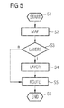
- the program is preferably started after a determination of the possible routes ROUTE in a step S1 in which variables are initialized if necessary.
- a display device signal is generated such that the map MAP is displayed, preferably with the possible routes ROUTE.
- a user of the navigation device is asked if one of the additional layers LAYER should be displayed. If the user selects one or more of the additional layers LAYER, the processing is continued in a step S3. If the user does not select any of the additional layers LAYER, the processing is continued in a step S5.
- step S4 the display device signal is generated such that at least one of the additional layers LAYER is displayed depending on the desire of the user of the navigation system.
- step S5 one of the possible routes ROUTE is selected.
- the program can be terminated.
- at least one of the additional layers LAYER is displayed to the user of the navigation device at any time at his request.
- the program can only be processed to display the additional layer LAYER independently of the route planning.
- the invention is not limited to the specified embodiments.
- at least one further additional layer LAYER may be displayed.
Abstract
Description
Die Erfindung betrifft ein Verfahren und eine Vorrichtung zum Betreiben eines Navigationsgeräts. Dabei wird ein Anzeigevorrichtungssignal derart erzeugt, dass vorgegebene Landkartendaten auf einer Anzeigevorrichtung des Navigationsgeräts in Form einer Landkarte dargestellt werden.The invention relates to a method and a device for operating a navigation device. In this case, a display device signal is generated such that predetermined map data is displayed on a display device of the navigation device in the form of a map.
Navigationsgeräte sind heutzutage weit verbreitet. Die Navigationsgeräte sind regelmäßig mobile Einheiten, die beispielsweise in tragbaren Gehäusen und/oder in Fahrzeugen angeordnet sind. Beispielsweise kann ein derartiges tragbares Navigationsgerät einem Fußgänger und/oder einem Wanderer erleichtern, an sein Ziel zu gelangen. Ferner kann das Navigationsgerät in einem Pkw und/oder einem Lkw angeordnet sein und zu privaten und/oder beruflichen Zwecken verwendet werden. Je nachdem, wo das Navigationsgerät angeordnet ist und/oder von wem das Navigationsgerät zu welchem Zweck benutzt wird, werden regelmäßig unterschiedliche Anforderungen an das Navigationsgerät gestellt. Beispielsweise benötigt der Fußgänger keine Informationen über Autobahnen und/oder über eine vorgegebene Durchfahrtshöhe unter einer Brücke, sondern Informationen über Fußwege. Ein Fahrer eines der Fahrzeuge hingegen kann die Informationen über Autobahnen und/oder Brücken gut gebrauchen. Insbesondere ein Fahrer des LKWs und/oder des Pkws, insbesondere wenn der Pkw einen Anhänger zieht, kann Informationen benötigen, die auf die Eigenschaften dieser speziellen Fahrzeuge beziehungsweise Fahrzeuggespanne abgestimmt sind.Navigation devices are widespread nowadays. The navigation devices are regularly mobile units, which are arranged for example in portable cases and / or in vehicles. For example, such a portable navigation device can make it easier for a pedestrian and / or a hiker to reach his destination. Furthermore, the navigation device can be arranged in a passenger car and / or a truck and be used for private and / or professional purposes. Depending on where the navigation device is arranged and / or by whom the navigation device is used for which purpose, regularly different requirements are placed on the navigation device. For example, the pedestrian needs no information about highways and / or about a given headroom under a bridge, but information about footpaths. A driver of one of the vehicles, however, can use the information about highways and / or bridges well. In particular, a driver of the truck and / or the car, especially if the car pulls a trailer, may require information that is tailored to the characteristics of these special vehicles or vehicle combination.
Es ist Aufgabe der Erfindung, ein Verfahren und eine Vorrichtung zum Betreiben eines Navigationsgeräts zu schaffen, das beziehungsweise die einfach eine erweiterte Routenplanung ermöglicht.It is an object of the invention to provide a method and an apparatus for operating a navigation device, which or simply allows an extended route planning.
Die Aufgabe wird gelöst durch die Merkmale der unabhängigen Ansprüche. Vorteilhafte Ausgestaltungen der Erfindung sind in den Unteransprüchen angegeben.The object is solved by the features of the independent claims. Advantageous embodiments of the invention are specified in the subclaims.
Die Erfindung zeichnet sich aus durch ein Verfahren und eine Vorrichtung zum Betreiben eines Navigationsgeräts. Es wird ein Anzeigevorrichtungssignal derart erzeugt, dass auf einer Anzeigevorrichtung des Navigationsgeräts vorgegebene Landkartendaten in Form einer Landkarte dargestellt werden. Einem Nutzer des Navigationsgeräts wird zumindest eine Zusatzschicht mit vorgegebenen Zusatzdaten angeboten. Die Zusatzdaten umfassen eine vorgegebene Art von Zusatzinformationen. Abhängig von einer Auswahl des Nutzers wird die Zusatzschicht ausgewählt. Das Anzeigevorrichtungssignal wird derart erzeugt, dass die Landkarte und die ausgewählte über die Landkarte gelegte Zusatzschicht dargestellt werden.The invention is characterized by a method and a device for operating a navigation device. A display device signal is generated such that given map data on a display device of the navigation device are displayed in the form of a map. A user of the navigation device is offered at least one additional layer with predetermined additional data. The additional data includes a predetermined type of additional information. Depending on a selection of the user, the additional layer is selected. The display device signal is generated such that the map and the selected overlay placed over the map are displayed.
Das Anzeigen der Zusatzschicht ermöglicht einfach, die Zusatzinformationen anzuzeigen, abhängig von der Auswahl des Nutzers des Navigationsgeräts. Diese Zusatzinformationen kann der Nutzer beim Navigieren und/oder bei einer Auswahl einer möglichen Route einfach berücksichtigen. Dies trägt einfach zu einer erweiterten Routenplanung bei. Das Anzeigen der Zusatzschicht impliziert regelmäßig ein Ermitteln der notwendigen Zusatzinformationen, insbesondere der Darstellungen der Zusatzinformationen und eine Lage der Darstellungen in der Landkarte. Gegenüber einem Navigationsgerät, bei dem für jede Art der Zusatzinformationen die ganze Landkarte mit den Zusatzinformationen abgespeichert wird, trägt das Speichern und das Anzeigen der Zusatzinformationen über die Zusatzschicht zu einem geringen Speicherplatzbedarf und zu einer kurzen Rechenzeit bei. Ferner ist darüber eine Datenreduktion beim Bildaufbau auf der Anzeigevorrichtung ermöglicht.Displaying the supplemental layer makes it easy to display the additional information, depending on the selection of the user of the navigation device. The user can easily take this additional information into account when navigating and / or selecting a possible route. This simply adds to extended route planning. Displaying the additional layer regularly implies determining the necessary additional information, in particular the representations of the additional information and a location of the representations in the map. Compared to a navigation device in which the entire map is stored with the additional information for each type of additional information, the storage and displaying the additional information on the additional layer contributes to a small storage space requirement and a short computing time. Furthermore, a data reduction during image construction on the display device is made possible.
In einer vorteilhaften Ausgestaltung des Verfahrens werden dem Nutzer zusätzlich zu der Zusatzschicht zumindest zwei mögliche Routen vorgeschlagen. Der Nutzer kann abhängig von der mit der Zusatzschicht angezeigten Landkarte eine der möglichen Routen auswählen. Der Nutzer wird automatisch abhängig von der ausgewählten Route geführt. Dies ermöglicht einfach und intuitiv, die Zusatzinformationen in eine Routenplanung mit einzubeziehen.In an advantageous embodiment of the method, at least two possible routes are proposed to the user in addition to the additional layer. The user can be dependent on the map displayed with the supplemental layer selects one of the possible routes. The user is guided automatically depending on the selected route. This makes it simple and intuitive to include the additional information in a route planning.
In einer weiteren vorteilhaften Ausgestaltung des Verfahrens ist die Art der Zusatzinformationen landschaftsspezifisch. Dies kann einfach dazu beitragen, dem Nutzer des Navigationsgeräts zu helfen, seine Route zu planen. Insbesondere wenn der Nutzer sich mit einem Fahrzeug fortbewegt, das nicht in der Lage ist, sich über alle landschaftsspezifischen Besonderheiten hinweg zu bewegen.In a further advantageous embodiment of the method, the type of additional information is landscape-specific. This can simply help the user of the navigation device to plan his route. In particular, when the user is traveling with a vehicle that is unable to move beyond all landscape-specific features.
In einer weiteren vorteilhaften Ausgestaltung des Verfahrens umfassen die landschaftsspezifischen Zusatzinformationen zumindest eine Höhenangabe. Dies kann einfach dazu beitragen, dem Nutzer des Navigationsgeräts zu helfen, seine Route zu planen. Insbesondere wenn der Nutzer sich mit einem Fahrzeug fortbewegt, das nicht in der Lage ist, sich über jegliche Höhenunterschiede hinweg zu bewegen.In a further advantageous embodiment of the method, the landscape-specific additional information comprise at least one altitude. This can simply help the user of the navigation device to plan his route. In particular, when the user is traveling with a vehicle that is unable to move beyond any height differences.
In einer weiteren vorteilhaften Ausgestaltung des Verfahrens ist die Art der Zusatzinformationen umweltverschmutzungsspezifisch. Dies kann einfach dazu beitragen, dem Nutzer des Navigationsgeräts zu helfen, seine Route zu planen. Insbesondere wenn der Nutzer aus gesundheitlichen und/oder umweltverschmutzungsspezifischen Gründen bestimmte Gebiete meiden möchte.In a further advantageous embodiment of the method, the type of additional information is pollution specific. This can simply help the user of the navigation device to plan his route. Especially if the user wants to avoid certain areas for health and / or environmental reasons.
In einer weiteren vorteilhaften Ausgestaltung des Verfahrens umfassen die umweltverschmutzungsspezifischen Zusatzinformationen ein Smog-Gebiet. Insbesondere können die umweltverschmutzungsspezifischen Zusatzinformationen die Lage und/oder Ausmaße des Smog-Gebiets umfassen. Dies kann einfach dazu beitragen, dem Nutzer des Navigationsgeräts zu helfen, seine Route zu planen. Insbesondere wenn der Nutzer aus gesundheitlichen und/oder umweltverschmutzungsspezifischen Gründen die Smog-Gebiete meiden möchte.In a further advantageous embodiment of the method, the environmental pollution-specific additional information comprises a smog area. In particular, the additional environmental information may include the location and / or dimensions of the smog area. This can simply help the user of the navigation device to plan his route. Especially if the user is from health and / or pollution-specific reasons, would like to avoid smog areas.
In einer weiteren vorteilhaften Ausgestaltung des Verfahrens ist die Art der Zusatzinformation streckenspezifisch. Die streckenspezifischen Zusatzinformationen können beispielsweise Tunnel, Brücken, insbesondere mit niedriger Durchfahrtshöhe, schmale Straßen, Gewichtsbeschränkungen auf Brücken und vieles mehr sein. Dies ist insbesondere vorteilhaft, wenn der Nutzer einen Lastkraftwagen und/oder ein Fahrzeuggespann fährt und/oder vorgegebene Strecken, beispielsweise die Tunnel, meiden möchte.In a further advantageous embodiment of the method, the type of additional information is route-specific. The route-specific additional information can be, for example, tunnels, bridges, in particular with low headroom, narrow streets, weight restrictions on bridges and much more. This is particularly advantageous if the user drives a truck and / or a vehicle combination and / or would like to avoid predetermined routes, for example the tunnels.
Die vorteilhaften Ausgestaltungen des Verfahrens können ohne weiteres auf vorteilhafte Ausgestaltungen der Vorrichtung übertragen werden.The advantageous embodiments of the method can be readily transferred to advantageous embodiments of the device.
Die Erfindung ist im Folgenden anhand von schematischen Zeichnungen näher erläutert.The invention is explained in more detail below with reference to schematic drawings.
Es zeigen:
Figur 1- einen Ausschnitt einer Landkarte,
Figur 2- der Ausschnitt der Landkarte mit einer ersten Zusatzschicht,
Figur 3- der Ausschnitt der Landkarte mit einer zweiten Zusatzschicht,
- Figur 4
- der Ausschnitt der Landkarte mit der ersten, der zweiten und einer dritten Zusatzschicht,
Figur 5- ein Verfahren zum Betreiben eines Navigationsgeräts.
- FIG. 1
- a section of a map,
- FIG. 2
- the section of the map with a first additional layer,
- FIG. 3
- the section of the map with a second additional layer,
- FIG. 4
- the section of the map with the first, the second and a third additional layer,
- FIG. 5
- a method for operating a navigation device.
Elemente gleicher Konstruktion oder Funktion sind figurenübergreifend mit den gleichen Bezugszeichen gekennzeichnet.Elements of the same construction or function are identified across the figures with the same reference numerals.
Ein Ausschnitt einer Landkarte MAP (
Das Navigationsgerät ist vorzugsweise ein tragbares Navigationsgerät und/oder in einem Kraftfahrzeug angeordnet. Zusätzlich zu der Landkarte MAP kann ein Nutzer des Navigationsgeräts zumindest eine, vorzugsweise mehrere Zusatzschichten LAYER auswählen, die jeweils eine vorgegebene Art von Zusatzinformationen umfassen. Alternativ dazu kann eine Zusatzschicht LAYER auch mehrere Arten von Zusatzinformationen umfassen.The navigation device is preferably a portable navigation device and / or arranged in a motor vehicle. In addition to the map MAP, a user of the navigation device can select at least one, preferably several additional layers LAYER, each of which includes a predetermined type of additional information. Alternatively, an additional layer LAYER may also comprise several types of additional information.
Die Art der Zusatzinformationen kann beispielsweise landschaftsspezifisch, umweltverschmutzungsspezifisch und/oder streckenspezifisch sein.The type of additional information can be landscape-specific, pollution-specific and / or route-specific, for example.
Die umweltverschmutzungsspezifische Zusatzinformation kann beispielsweise in einer ersten Zusatzschicht LAYER enthalten sein und eine Existenz und/oder eine Lage eines Smog-Gebiets 8 (
Falls der Nutzer aus gesundheitlichen und/oder umweltverschmutzungsspezifischen Aspekten das Smog-Gebiet 8 meiden möchte, so kann er es einfach umfahren. Alternativ dazu können die Zusatzinformationen auch in eine Routenplanung mittels des Navigationsgeräts eingebunden werden. Beispielsweise kann sich der Nutzer abhängig von einem vorgegebenen Startort und einem vorgegebenen Zielort mehrere mögliche Routen ROUTE anzeigen lassen. Nach Zuschalten der Zusatzschicht LAYER kann der Nutzer dann eine der möglichen Routen ROUTE auswählen, die beispielsweise nicht durch das Smog-Gebiet 8 verläuft. Falls das Navigationsgerät mehrere mögliche Routen ROUTE darstellt, sind diese vorzugsweise verschiedenfarbig dargestellt.If the user wishes to avoid the smog area 8 for health and / or environmental aspects, he can easily avoid it. Alternatively, the additional information can also be integrated into a route planning by means of the navigation device. For example, the user can display a number of possible ROUTE routes depending on a predetermined start location and a predetermined destination. After connecting the additional layer LAYER, the user can then select one of the possible routes ROUTE, which does not run through the smog area 8, for example. If the navigation device displays several possible routes ROUTE, these are preferably shown in different colors.
Die landschaftsspezifischen Zusatzinformationen können beispielsweise in einer zweiten Zusatzschicht LAYER enthalten sein und umfassen vorzugsweise Höhenangaben 10 (
Die streckenspezifischen Zusatzinformationen können beispielsweise in einer dritten Zusatzschicht LAYER enthalten sein und einen Tunnel 12 (
Die Zusatzschichten LAYER können einzeln oder zusammen, übereinander gelegt dargestellt werden.The additional layers LAYER can be displayed individually or together, one above the other.
Jede einzelne der Zusatzschichten LAYER benötigt im Vergleich zu der Landkarte MAP lediglich einen geringen Speicherplatz. Ferner kann die im Vergleich zu der Datenmenge der gesamten Landkarte MAP geringe Datenmenge der Zusatzschicht LAYER von dem Navigationsgerät schnell verarbeitet und angezeigt werden. Dies trägt dazu bei, dass eine Rechenzeit zum Darstellen der Zusatzinformationen in der Zusatzschicht LAYER auf der bereits dargestellten Landkarte MAP sehr kurz sein kann, im Vergleich zu der Rechenzeit, die benötigt werden würde, wenn die Zusatzinformationen in der Landkarte, insbesondere in den Landkartendaten enthalten wären, und wenn für jede Art von Zusatzinformationen immer die gesamte Landkarte MAP geladen werden müsste.Each of the additional layers LAYER requires only a small storage space compared to the map MAP. Furthermore, the data volume of the additional layer LAYER, which is small compared to the data volume of the entire map MAP, can be processed and displayed quickly by the navigation device. This contributes to the fact that a computing time for displaying the additional information in the additional layer LAYER on the map MAP already shown can be very short, compared to the computing time that would be required if the additional information contained in the map, in particular in the map data would be, and if for any kind of additional information always the entire map MAP would have to be loaded.
Ferner ermöglicht die Zusatzschicht LAYER, dass der Nutzer die Darstellung des Navigationsgeräts individuell auf seine Bedürfnisse anpassen kann. Beispielsweise kann sich der Lkw-Fahrer die Höhenangaben und die kostenpflichtigen Streckenabschnitte anzeigen lassen. Im Gegensatz dazu kann der Pkw-Fahrer, der beispielsweise einen Ausflug macht, sich lediglich das Smog-Gebiet 8 anzeigen lassen.Furthermore, the additional layer LAYER allows the user to customize the presentation of the navigation device individually to his needs. For example, the truck driver can display the altitude information and the paid sections. In contrast, the car driver who makes a trip, for example, can only display the smog area 8.
Auf einer Speichervorrichtung des Navigationsgeräts ist vorzugsweise ein Programm zum Betreiben des Navigationsgeräts gespeichert. Eine Steuervorrichtung des Navigationsgeräts kann auch als Vorrichtung zum Betreiben des Navigationsgeräts bezeichnet werden. Das Programm wird vorzugsweise nach einem Ermitteln der möglichen Routen ROUTE in einem Schritt S1 gestartet, in dem gegebenenfalls Variablen initialisiert werden.A program for operating the navigation device is preferably stored on a storage device of the navigation device. A control device of the navigation device may also be referred to as a device for operating the navigation device. The program is preferably started after a determination of the possible routes ROUTE in a step S1 in which variables are initialized if necessary.
In einem Schritt S2 wird ein Anzeigevorrichtungssignal derart erzeugt, dass die Landkarte MAP angezeigt wird, vorzugsweise mit den möglichen Routen ROUTE.In a step S2, a display device signal is generated such that the map MAP is displayed, preferably with the possible routes ROUTE.
In einem Schritt S3 wird ein Nutzer des Navigationsgeräts gefragt, ob eine der Zusatzschichten LAYER angezeigt werden soll. Wählt der Nutzer eine oder mehrere der Zusatzschichten LAYER aus, so wird die Bearbeitung in einem Schritt S3 fortgesetzt. Wählt der Nutzer keine der Zusatzschichten LAYER aus, so wird die Bearbeitung in einem Schritt S5 fortgesetzt.In a step S3, a user of the navigation device is asked if one of the additional layers LAYER should be displayed. If the user selects one or more of the additional layers LAYER, the processing is continued in a step S3. If the user does not select any of the additional layers LAYER, the processing is continued in a step S5.
In dem Schritt S4 wird das Anzeigevorrichtungssignal derart erzeugt, dass zumindest eine der Zusatzschichten LAYER angezeigt wird abhängig von dem Wunsch des Nutzers des Navigationssystems.In step S4, the display device signal is generated such that at least one of the additional layers LAYER is displayed depending on the desire of the user of the navigation system.
In dem Schritt S5 wird eine der möglichen Routen ROUTE ausgewählt.In step S5, one of the possible routes ROUTE is selected.
In einem Schritt S6 kann das Programm beendet werden. Vorzugsweise wird dem Nutzer des Navigationsgeräts jederzeit auf dessen Wunsch zumindest eine der Zusatzschichten LAYER angezeigt. Das Programm kann lediglich zum Darstellen der Zusatzschicht LAYER auch unabhängig von der Routenplanung abgearbeitet werden.In a step S6, the program can be terminated. Preferably, at least one of the additional layers LAYER is displayed to the user of the navigation device at any time at his request. The program can only be processed to display the additional layer LAYER independently of the route planning.
Die Erfindung ist nicht auf die angegebenen Ausführungsbeispiele beschränkt. Beispielsweise können alternativ oder zusätzlich zu der ersten, zweiten und/oder dritten Zusatzschicht LAYER zumindest eine weitere Zusatzschicht LAYER angezeigt werden.The invention is not limited to the specified embodiments. For example, as an alternative or in addition to the first, second and / or third additional layer LAYER, at least one further additional layer LAYER may be displayed.
Claims (8)
Applications Claiming Priority (1)
| Application Number | Priority Date | Filing Date | Title |
|---|---|---|---|
| DE200610057598 DE102006057598A1 (en) | 2006-12-06 | 2006-12-06 | Method and device for operating a navigation device |
Publications (2)
| Publication Number | Publication Date |
|---|---|
| EP1930695A2 true EP1930695A2 (en) | 2008-06-11 |
| EP1930695A3 EP1930695A3 (en) | 2011-05-04 |
Family
ID=39149139
Family Applications (1)
| Application Number | Title | Priority Date | Filing Date |
|---|---|---|---|
| EP07121718A Withdrawn EP1930695A3 (en) | 2006-12-06 | 2007-11-28 | Method and device for operating a navigational device |
Country Status (2)
| Country | Link |
|---|---|
| EP (1) | EP1930695A3 (en) |
| DE (1) | DE102006057598A1 (en) |
Cited By (1)
| Publication number | Priority date | Publication date | Assignee | Title |
|---|---|---|---|---|
| WO2015067799A1 (en) * | 2013-11-11 | 2015-05-14 | Continental Automotive Gmbh | Navigation system for taking use restrictions into consideration in particular, and method for operating same |
Families Citing this family (2)
| Publication number | Priority date | Publication date | Assignee | Title |
|---|---|---|---|---|
| DE102013202464A1 (en) | 2013-02-15 | 2014-08-21 | Bayerische Motoren Werke Aktiengesellschaft | Method for calculating route from start point to end point based on map, involves calculating route from start point to end point while avoiding road segments of second type, which are included in area |
| DE102017213209A1 (en) * | 2017-08-01 | 2019-02-07 | Bayerische Motoren Werke Aktiengesellschaft | Consideration of the air quality in the vehicle |
Citations (4)
| Publication number | Priority date | Publication date | Assignee | Title |
|---|---|---|---|---|
| US5884219A (en) * | 1996-10-10 | 1999-03-16 | Ames Maps L.L.C. | Moving map navigation system |
| US20020065605A1 (en) * | 2000-11-29 | 2002-05-30 | Alpine Electronics, Inc.. | Method of displaying poi icons for navigation apparatus |
| DE102004005750A1 (en) * | 2003-02-05 | 2004-09-30 | Xanavi Informatics Corp., Zama | Route searching and selection method for a vehicle navigation device in which stored historical statistical travel time data is used in selecting a route |
| US20040243299A1 (en) * | 2003-02-05 | 2004-12-02 | Scaer Robert M. | Intelligent road and rail information systems and methods |
Family Cites Families (10)
| Publication number | Priority date | Publication date | Assignee | Title |
|---|---|---|---|---|
| EP1708151A3 (en) * | 1995-08-09 | 2007-01-24 | Toyota Jidosha Kabushiki Kaisha | Travel plan preparing device |
| JP4080649B2 (en) * | 1999-09-20 | 2008-04-23 | パイオニア株式会社 | Human navigation system |
| DE19948381A1 (en) * | 1999-10-07 | 2001-05-03 | Allianz Zentrum Fuer Technik G | Traffic management system calculates individual route based on environment, road condition, traffic volume and communicates information to user terminals e.g. mobile phones |
| DE10044935B4 (en) * | 2000-09-12 | 2010-12-16 | Robert Bosch Gmbh | navigation device |
| JP2003185453A (en) * | 2001-12-20 | 2003-07-03 | Mitsubishi Electric Corp | Navigation device and pathfinding method |
| JP3908056B2 (en) * | 2002-02-26 | 2007-04-25 | アルパイン株式会社 | Car navigation system |
| JP2003254761A (en) * | 2002-02-28 | 2003-09-10 | Fujitsu Ten Ltd | Navigation device |
| DE10356459B4 (en) * | 2003-12-03 | 2006-04-20 | Adam Opel Ag | Method and device for navigating a motor vehicle |
| US7373244B2 (en) * | 2004-04-20 | 2008-05-13 | Keith Kreft | Information mapping approaches |
| DE102005003081B4 (en) * | 2005-01-22 | 2009-03-05 | Audi Ag | Navigation system and method for driving route determination |
-
2006
- 2006-12-06 DE DE200610057598 patent/DE102006057598A1/en not_active Ceased
-
2007
- 2007-11-28 EP EP07121718A patent/EP1930695A3/en not_active Withdrawn
Patent Citations (4)
| Publication number | Priority date | Publication date | Assignee | Title |
|---|---|---|---|---|
| US5884219A (en) * | 1996-10-10 | 1999-03-16 | Ames Maps L.L.C. | Moving map navigation system |
| US20020065605A1 (en) * | 2000-11-29 | 2002-05-30 | Alpine Electronics, Inc.. | Method of displaying poi icons for navigation apparatus |
| DE102004005750A1 (en) * | 2003-02-05 | 2004-09-30 | Xanavi Informatics Corp., Zama | Route searching and selection method for a vehicle navigation device in which stored historical statistical travel time data is used in selecting a route |
| US20040243299A1 (en) * | 2003-02-05 | 2004-12-02 | Scaer Robert M. | Intelligent road and rail information systems and methods |
Cited By (1)
| Publication number | Priority date | Publication date | Assignee | Title |
|---|---|---|---|---|
| WO2015067799A1 (en) * | 2013-11-11 | 2015-05-14 | Continental Automotive Gmbh | Navigation system for taking use restrictions into consideration in particular, and method for operating same |
Also Published As
| Publication number | Publication date |
|---|---|
| DE102006057598A1 (en) | 2008-06-12 |
| EP1930695A3 (en) | 2011-05-04 |
Similar Documents
| Publication | Publication Date | Title |
|---|---|---|
| DE69911399T2 (en) | METHOD FOR DISPLAYING A CURRENT VEHICLE POSITION BY NAVIGATION SYSTEM | |
| DE69731860T2 (en) | Navigation device for land vehicles with limited display for route guidance to improve readability | |
| DE102011085893A1 (en) | Systems and methods for planning vehicle routes based on safety factors | |
| DE112007002389T5 (en) | navigation device | |
| DE102004032346B4 (en) | Method for piloting vehicles and vehicle control system | |
| DE102012013376A1 (en) | Driver assistance system | |
| DE112007002388T5 (en) | navigation device | |
| DE102008028374A1 (en) | Method for combined output of an image and local information, and motor vehicle therefor | |
| DE102006027832A1 (en) | Car navigation system | |
| WO2007112849A2 (en) | Navigation arrangement and navigation method for a motor vehicle | |
| EP2146184A2 (en) | Method for inputting and presenting information in a navigation system | |
| EP3410069A1 (en) | Motor vehicle, navigation device and method for assisting a user of a motor vehicle whilst driving the motor vehicle | |
| DE112014001209T5 (en) | Navigation according to permitted travel times | |
| DE10258161B4 (en) | Vehicle navigation system and related method | |
| EP1930695A2 (en) | Method and device for operating a navigational device | |
| DE19941966A1 (en) | Method, for displaying warning messages about traffic hold-ups and road conditions, involves using navigation system and display unit showing digital road map with pointer | |
| EP1039429B1 (en) | Procedure for portable route guidance with an on-board navigation equipment as well as portable navigation system | |
| EP0978705A2 (en) | Method for route calculation in a navigation apparatus and navigation apparatus for performing this method | |
| DE102009002117A1 (en) | Route suggestion generating method for e.g. lorry, involves considering dimension e.g. length, width, height, wheel base, maximum steering angle and/or minimum radius of turning circle, of vehicle during generation of route suggestion | |
| EP2028445A2 (en) | Method of and device for determining a route in a road network | |
| DE102005012131B3 (en) | Method of determining the upper speed limit for a vehicle over a given route where a maximum speed limit is given | |
| EP2557397B1 (en) | Method for determining a route using a navigation system | |
| DE102013009711A1 (en) | Assistance system to assist a driver of a motor vehicle | |
| DE102011119752A1 (en) | Method for route guidance of vehicle e.g. motor car, involves determining and outputting driving instructions for bending process required at road forkings/road junctions of route depending on assigned characteristics | |
| EP1255092B1 (en) | Device and method for displaying information in a vehicle |
Legal Events
| Date | Code | Title | Description |
|---|---|---|---|
| PUAI | Public reference made under article 153(3) epc to a published international application that has entered the european phase |
Free format text: ORIGINAL CODE: 0009012 |
|
| AK | Designated contracting states |
Kind code of ref document: A2 Designated state(s): AT BE BG CH CY CZ DE DK EE ES FI FR GB GR HU IE IS IT LI LT LU LV MC MT NL PL PT RO SE SI SK TR |
|
| AX | Request for extension of the european patent |
Extension state: AL BA HR MK RS |
|
| RAP1 | Party data changed (applicant data changed or rights of an application transferred) |
Owner name: CONTINENTAL AUTOMOTIVE GMBH |
|
| PUAL | Search report despatched |
Free format text: ORIGINAL CODE: 0009013 |
|
| AK | Designated contracting states |
Kind code of ref document: A3 Designated state(s): AT BE BG CH CY CZ DE DK EE ES FI FR GB GR HU IE IS IT LI LT LU LV MC MT NL PL PT RO SE SI SK TR |
|
| AX | Request for extension of the european patent |
Extension state: AL BA HR MK RS |
|
| AKY | No designation fees paid | ||
| REG | Reference to a national code |
Ref country code: DE Ref legal event code: R108 |
|
| REG | Reference to a national code |
Ref country code: DE Ref legal event code: R108 Effective date: 20120111 |
|
| STAA | Information on the status of an ep patent application or granted ep patent |
Free format text: STATUS: THE APPLICATION IS DEEMED TO BE WITHDRAWN |
|
| 18D | Application deemed to be withdrawn |
Effective date: 20111105 |