EP2804151A1 - Method for rendering data of a three-dimensional surface - Google Patents
Method for rendering data of a three-dimensional surface Download PDFInfo
- Publication number
- EP2804151A1 EP2804151A1 EP13167982.1A EP13167982A EP2804151A1 EP 2804151 A1 EP2804151 A1 EP 2804151A1 EP 13167982 A EP13167982 A EP 13167982A EP 2804151 A1 EP2804151 A1 EP 2804151A1
- Authority
- EP
- European Patent Office
- Prior art keywords
- tile
- buffer
- tiles
- value
- distance value
- Prior art date
- Legal status (The legal status is an assumption and is not a legal conclusion. Google has not performed a legal analysis and makes no representation as to the accuracy of the status listed.)
- Granted
Links
Images


Classifications
-
- G—PHYSICS
- G06—COMPUTING; CALCULATING OR COUNTING
- G06T—IMAGE DATA PROCESSING OR GENERATION, IN GENERAL
- G06T15/00—3D [Three Dimensional] image rendering
- G06T15/04—Texture mapping
-
- G—PHYSICS
- G06—COMPUTING; CALCULATING OR COUNTING
- G06T—IMAGE DATA PROCESSING OR GENERATION, IN GENERAL
- G06T1/00—General purpose image data processing
- G06T1/60—Memory management
-
- G—PHYSICS
- G06—COMPUTING; CALCULATING OR COUNTING
- G06T—IMAGE DATA PROCESSING OR GENERATION, IN GENERAL
- G06T15/00—3D [Three Dimensional] image rendering
- G06T15/10—Geometric effects
- G06T15/40—Hidden part removal
-
- G—PHYSICS
- G06—COMPUTING; CALCULATING OR COUNTING
- G06T—IMAGE DATA PROCESSING OR GENERATION, IN GENERAL
- G06T17/00—Three dimensional [3D] modelling, e.g. data description of 3D objects
- G06T17/05—Geographic models
-
- G—PHYSICS
- G06—COMPUTING; CALCULATING OR COUNTING
- G06T—IMAGE DATA PROCESSING OR GENERATION, IN GENERAL
- G06T2200/00—Indexing scheme for image data processing or generation, in general
- G06T2200/04—Indexing scheme for image data processing or generation, in general involving 3D image data
-
- G—PHYSICS
- G06—COMPUTING; CALCULATING OR COUNTING
- G06T—IMAGE DATA PROCESSING OR GENERATION, IN GENERAL
- G06T2210/00—Indexing scheme for image generation or computer graphics
- G06T2210/36—Level of detail
Definitions
- the present invention pertains to a method for rendering data of a three-dimensional surface, particularly a terrain, having a multitude of detail levels, the method particularly preventing the formation of rendering artifacts due to overlapping.
- Rendering is the process of generating an image from a model such as a three-dimensional terrain model by means of a computer programme.
- the three-dimensional terrain model to be rendered can be a grid containing elevation data, such as a Digital Elevation Model (DEM), a Digital Surface Model (DSM) or a Digital Terrain Model (DTM).
- the digital model may comprise data of a limited area, such as a model of a particular city or landscape, as well as a model of a continent or even a complete planet.
- a tree which divides the data into tiles and levels of detail, wherein each level of detail comprises more information than the previous one, thus allowing zooming in or out while keeping the rendering quality and preserving the amount of memory needed on the device.
- overlapping tiles on top of each other will appear, i.e. tiles that cover the same area, but have a different detail level.
- these tiles do not comprise the exactly same amount of information, the tiles are not perfectly overlapping.
- This problem appears, because tiles of a higher detail level, i.e. tiles comprising more information, should be displayed on top of tiles of a lower detail level, i.e. tiles including less information. But due to overlapping, it may happen that some part of a tile of a lower detail level is displayed - partially or completely - on top of another tile of a higher detail level, leading to so-called artifacts.
- One method employs the use of a "clipping plane". For avoiding overlapping, such a method comprises determining for each tile, which area of the tile should be rendered. Disadvantageously, this method is relatively slow, especially on mobile devices, since complex 3D calculus needs to take place as well as complex logic for determining the area of the tile that needs to be rendered.
- Another method uses the "depth offset”. Therein, an offset is added to each tile using its level of detail value. The main problem of this approach is that it adds a "hovering" effect on all the tiles on top of each other and does not work if the amount of data on the data levels varies strongly.
- a method for displaying a representation of a portion of a three-dimensional surface by rendering data representing physical features of the portion of the three-dimensional surface, the data being apportioned into a multitude of tiles at a plurality of different detail levels, the representation comprising a multitude of image pixels, a buffer being assigned to each image pixel, with
- rendering is performed sequentially for every tile and in the order of the distance value of the tiles.
- the rendering comprises storing the distance value as a new buffer value in the buffer of the respective pixel and displaying data information from the tile in the pixel.
- the buffer is a stencil buffer.
- the stencil buffer is an extra buffer - usually with a depth of one byte per pixel - that is found on modern graphics hardware, additionally to the colour buffer and the depth buffer of a pixel.
- the representation is a two- or three-dimensional image, which is displayable to a user on a display.
- the data is a Digital Elevation Model (DEM), Digital Surface Model (DSM) or Digital Terrain Model (DTM).
- DEM Digital Elevation Model
- DSM Digital Surface Model
- DTM Digital Terrain Model
- the tiles to be rendered are sorted according to their position in the image and then rendered sequentially, thus avoiding complex 3D calculus.
- the method comprises sorting the tiles in a list according to a location of the tiles with respect to the representation, wherein
- the location of the tiles is a distance between the tiles and an observation point, e.g. a virtual position of a virtual camera, or between the tiles and a centre point of the representation, particularly a distance between the observation point or the centre point of the representation and the centre of a bounding box of each tile, or a distance between the observation point or the centre point of the representation and the nearest side of the bounding box.
- an observation point e.g. a virtual position of a virtual camera
- the tiles and a centre point of the representation particularly a distance between the observation point or the centre point of the representation and the centre of a bounding box of each tile, or a distance between the observation point or the centre point of the representation and the nearest side of the bounding box.
- the default buffer value and the distance value that is assigned to the first tile in the list are the minimum and maximum values in a number range of the buffer.
- the buffer is an 8 bit buffer and either
- the distance value is
- comparing comprises determining whether a buffer value of a pixel or a distance value of a presently rendered is smaller than the other. If the distance value assigned to the nearest tile is larger than the default buffer value stored in the buffers of the image pixels, comparing comprises determining whether the present buffer value of a pixel is smaller than the distance value of a presently rendered tile, and if the distance value assigned to the nearest tile is smaller than the default buffer value stored in the buffers of the image pixels, comparing comprises determining whether the present buffer value of a pixel is larger than the distance value of a presently rendered tile. If the result of said determining is positive, the distance value is stored as a new buffer value in the buffer of the respective pixel and data information from the tile is displayed in the respective pixel.
- the method is executed on a mobile device comprising a display for displaying the representation to a user, the mobile device particularly being a navigation device, a mobile phone, in particular a Smartphone, or a tablet computer.
- the invention also relates to a mobile device for execution of said method.
- a mobile device comprises a display adapted for displaying a representation of a portion of a three-dimensional surface, and a rendering unit for rendering data representing physical features of the portion of the three-dimensional surface, the data being apportioned into a multitude of tiles at a plurality of different detail levels, the representation comprising a multitude of image pixels, each image pixel having a buffer, wherein the rendering unit is adapted for
- the rendering unit comprises a sorting algorithm, adapted for sorting the tiles in a list according to a location of the tiles in the representation, wherein
- the rendering unit is adapted for storing the distance value of a presently rendered tile as a new buffer value in the buffer of the respective pixel.
- the mobile device comprises locating means, particularly a GNSS receiver, for detecting a present location of the device.
- the mobile device comprises communicating means for wirelessly receiving the data for rendering from an external server.
- the invention furthermore relates to a computer programme product for execution of said method.
- a computer programme product comprises programme code which is stored on a machine-readable medium, or being embodied by an electromagnetic wave comprising a programme code segment, and has computer-executable instructions for performing, in particular when run on calculation means of a mobile device according to the invention, the following steps of the method according to the invention:
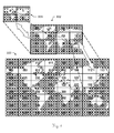
- Figure 1 shows an example for a representation of a terrain in three different detail levels 331-333.
- the representation is subdivided into a multitude of tiles, each of which particularly comprising a bitmap of a part of the representation.
- Each tile is assigned a number from which its position and detail level can be derived.
- each tile is comprised by a certain data file.
- the first detail level comprises the lowest amount of details.
- the terrain is subdivided into the four rectangular tiles with the numbers “0", “1”, “2” and “3”, each corresponding to four tiles of the second detail level 332 which is, thus, subdivided into sixteen tiles.
- Tile "2" of the first detail level e.g. corresponds to tiles “20", “21”, “22” and “23” of the second detail level.
- Each of the second detail level tiles corresponds to four tiles of the next higher level, the third detail level 333, so that this level is subdivided into sixty-four tiles.
- Tile "13” of the second detail level e.g. corresponds to tiles "130", “131", “132” and "133" of the second detail level.
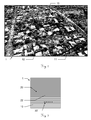
- Figure 2 shows an image 1 after rendering, being displayed to a user in a virtual camera view.
- the image 1 is composed of a multitude of pixels (not shown) and has a centre point 15.
- the image is a representation of a three-dimensional landscape 11 showing objects in a high detail level, the representation being composed by a multitude of tiles (not shown).
- an artifact 12 is shown, displaying the landscape in a considerably lower detail level.
- the tiles of the image 1 are displayed three-dimensionally with overlapping tiles on top of each other, i.e. tiles that at least partially cover the same area, but have a different detail level. As these tiles do not comprise the exactly same amount of information, the tiles are not perfectly fitting. Tiles of a higher detail level, i.e. tiles comprising more information, are ought to be displayed on top of tiles of a lower detail level, i.e. tiles including fewer information. But due to overlapping, some part of a tile of a lower detail level can be displayed on top of another tile of a higher detail level, leading to the depicted artifact 12. It is an object of the present invention to avoid the formation of such artifacts 12, by adding a specific value to every tile and every pixel of the image 1.
- Figure 3 schematically shows two tiles 20,20' - one of which particularly having a higher detail level than the other - of a representation 1 that have an overlapping area 22.
- the representation 1 comprises a multitude of pixels 10, wherein for the overlapping area 22 two sets of pixels are available to be displayed. Preferably, those pixels belonging to the tile 20,20' having a desired detail level should be displayed. Displaying the wrong set of pixels generally leads to the formation of an artifact.
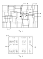
- FIG. 4 shows a flow chart describing an exemplary embodiment of a method 100 according to the invention.
- the depicted method 100 comprises the following steps 110-180:
- the method 100 ends when all pixels of the image display a portion of one of the tiles.
- step 130 it is also possible to assign the lowest distance value to the nearest tile and the highest distance value to the farthest tile, e. g. starting with zero for the nearest tile.
- step 140 the assigned default buffer value would then be the highest possible value - in an 8 bit buffer working on integer values this would be 255.
- step 160 the comparing of the two values would also have to be adapted accordingly, i.e. if the buffer value of the pixel exceeds the distance value of the tile, the method continues with step 170, and if the buffer value of the pixel is equal or smaller than the distance value of the tile, the respective pixel is discarded.
- Figure 5a an image 1 that is to be displayed to a user and is formed by a multitude of overlapping tiles is depicted schematically.
- Figure 5a illustrates the determination of the distances to the tiles for sorting the tiles according to their distance.
- a central point 15 of the image 1 is shown, from which a distance to each of the tiles is determined.
- Two possible distances are shown for one exemplary tile 20.
- the distance d 1 is measured from the central point 15 to the centre 25 of the respective tile 20, particularly the centre of a bounding box 21 of the tile.
- the distance d 2 is measured from the central point 15 to the nearest point on the edge of the tile 20, particularly the nearest point of the bounding box 21.
- the distance from the observation point i.e. a position of a virtual camera, can be determined.
- the tiles are sorted in a list according to their distance.
- An example of such a list 2 is shown in Figure 5b .
- Every tile 20 is then assigned an unambiguous distance value 28 according to the tile's position in the list 2. Particularly (as shown here), the nearest tile (having the lowest distance) is assigned the highest distance value 28, and for every following tile in the list 2 the distance value 28 is decremented by one. If the buffer used for storing the buffer value, in particular the stencil buffer, is an 8 bit buffer, the distance value for the nearest value could be 255.
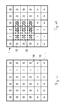
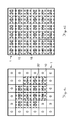
- Figures 6a-d show an image 1 comprising a multitude of pixels 10 - in this simplified example a 6 ⁇ 6 array of pixels 10.
- the figures illustrate the subsequent rendering of a number of tiles 20 - each tile 20 in this simplified example corresponding to a 3 ⁇ 3 array of pixels of the image 1.
- Each pixel 10 of the image 1 is shown with its actual buffer value 18.
- the buffer value 18 is assigned to a stencil buffer of the respective pixel, the stencil buffer being an 8 bit buffer.
- FIG 6b a situation is depicted in which a first tile 20 has been rendered that is assigned a distance value of 255 - the highest possible integer value when using an 8 bit buffer.
- the current buffer value 18 of the respective pixel and the distance value of the presently rendered tile 20 are compared (step 160 in Figure 4 ).
- the distance value exceeds the buffer value 18 of all nine pixels (255 > 0)
- the distance value is assigned to the nine pixels' stencil buffer as a new buffer value 18 (step 170 in Figure 4 ).
- the data of the tile is then displayed by the nine pixels 10 of the image 1 (step 180 in Figure 4 ); this is represented by a dotted background.
- a second tile 20' which is assigned a distance value lower than that of the first tile 20 - here a value of 254 - is rendered subsequently to the first tile 20.
- This second tile 20' partially overlaps with the first tile.
- the nine buffer values 18 and the distance value are compared (step 160 in Figure 4 ).
- the distance value is smaller than the present buffer value 18 (254 ⁇ 255), so that this area of the second tile 20' is discarded without further action, i.e. without displaying this area of the second tile 20'. This means that the respective pixels 10 of the image 1 remain unaltered.
- the distance value exceeds the buffer value 18 (254 > 0), so that the distance value is assigned to the pixels' stencil buffer as a new buffer value 18 (step 170 in Figure 4 ) and this area of the tile 20' is displayed by the five pixels 10 (step 180 in Figure 4 ) - again represented by the dotted background.
- Figure 6d shows the image 1 after the rendering of seven further tiles (not shown) having distance values of 253, 252, 251, 250, 249, 248 and 247, respectively.
- all pixels 10 of the image 1 are assigned one of the tiles' distance values as a new buffer value 18.
- Figure 7 shows an exemplary embodiment of a mobile device 30 according to the invention.
- the device is hand-held and comprises a rendering unit (not shown) for rendering data representing physical features of a portion of a three-dimensional surface, particularly by the method according to the invention as described above.
- the mobile device furthermore comprises a display 31, particularly designed as a touch-screen, the display 31 being adapted for displaying an image based on the data rendered by the rendering unit.
- the display 31 comprises a zoom functionality 33 for zooming in and out, i.e. changing the detail level of the displayed data.
- the device comprises locating means, such as a GNSS receiver, and communicating means for wirelessly receiving the data from a server.
Abstract
Description
- The present invention pertains to a method for rendering data of a three-dimensional surface, particularly a terrain, having a multitude of detail levels, the method particularly preventing the formation of rendering artifacts due to overlapping.
- Rendering is the process of generating an image from a model such as a three-dimensional terrain model by means of a computer programme. The three-dimensional terrain model to be rendered can be a grid containing elevation data, such as a Digital Elevation Model (DEM), a Digital Surface Model (DSM) or a Digital Terrain Model (DTM). The digital model may comprise data of a limited area, such as a model of a particular city or landscape, as well as a model of a continent or even a complete planet.
- When rendering three-dimensional terrain data in a computer, it is important to partition the data in such a way that not all of the data needs to be stored in the memory of the device, thus reducing the amount of memory needed on the device. This is especially important for mobile devices, which generally have particularly limited memory capacities.
- Computer rendering of three-dimensional terrain images is generally known from prior art:
US 7,551,172 B2 discloses a method for sending information representing three-dimensional images over a network, andUS 6,496,189 B1 discloses a method and apparatus for displaying images of an area as seen from an interactively chosen viewpoint on a remote device. - In a common method for rendering three-dimensional terrain data, a tree is used, which divides the data into tiles and levels of detail, wherein each level of detail comprises more information than the previous one, thus allowing zooming in or out while keeping the rendering quality and preserving the amount of memory needed on the device. Disadvantageously, if the tiles are displayed three-dimensionally, overlapping tiles on top of each other will appear, i.e. tiles that cover the same area, but have a different detail level. As these tiles do not comprise the exactly same amount of information, the tiles are not perfectly overlapping. This problem appears, because tiles of a higher detail level, i.e. tiles comprising more information, should be displayed on top of tiles of a lower detail level, i.e. tiles including less information. But due to overlapping, it may happen that some part of a tile of a lower detail level is displayed - partially or completely - on top of another tile of a higher detail level, leading to so-called artifacts.
- Various methods to remove these artifacts are known from prior art. One method employs the use of a "clipping plane". For avoiding overlapping, such a method comprises determining for each tile, which area of the tile should be rendered. Disadvantageously, this method is relatively slow, especially on mobile devices, since complex 3D calculus needs to take place as well as complex logic for determining the area of the tile that needs to be rendered.
- Another method uses the "depth offset". Therein, an offset is added to each tile using its level of detail value. The main problem of this approach is that it adds a "hovering" effect on all the tiles on top of each other and does not work if the amount of data on the data levels varies strongly.
- It is therefore an object of the present invention to provide an enhanced method for rendering three-dimensional data.
- It is a particular object of the invention to provide such a method that avoids the disadvantages of the methods known from prior art.
- It is a further object of the invention to provide such a method for rendering data of a three-dimensional terrain model.
- Furthermore, it is an object of the present invention to provide such a method being executable on a hand-held mobile device, and to provide a hand-held device for execution of said method.
- It is another object of the invention to provide a computer programme product for execution of said method, in particular on a hand-held device.
- At least one of these objects is achieved by the method according to
claim 1, the mobile device according toclaim 12, the computer programme product according toclaim 15 and/or the dependent claims of the present invention. - A method for displaying a representation of a portion of a three-dimensional surface by rendering data representing physical features of the portion of the three-dimensional surface, the data being apportioned into a multitude of tiles at a plurality of different detail levels, the representation comprising a multitude of image pixels, a buffer being assigned to each image pixel, with
- ● identifying tiles that need to be rendered,
- ● rendering the identified tiles, wherein at least a portion of a tile is displayed by a multitude of image pixels,
- assigning an unambiguous distance value to each of the identified tiles, and
- storing a default buffer value in the buffers of the image pixels,
- In one embodiment of the method, rendering is performed sequentially for every tile and in the order of the distance value of the tiles.
- In one embodiment of the method, depending on the result of comparing the buffer value and the distance value, the rendering comprises storing the distance value as a new buffer value in the buffer of the respective pixel and displaying data information from the tile in the pixel.
- In a preferred embodiment of the method, the buffer is a stencil buffer. For storing the distance value, particularly the stencil buffer is employed. The stencil buffer is an extra buffer - usually with a depth of one byte per pixel - that is found on modern graphics hardware, additionally to the colour buffer and the depth buffer of a pixel.
- In one embodiment of the method, the representation is a two- or three-dimensional image, which is displayable to a user on a display.
- In another embodiment of the method, the data is a Digital Elevation Model (DEM), Digital Surface Model (DSM) or Digital Terrain Model (DTM).
- According to one embodiment of the method of the present invention, the tiles to be rendered are sorted according to their position in the image and then rendered sequentially, thus avoiding complex 3D calculus. In this embodiment, the method comprises sorting the tiles in a list according to a location of the tiles with respect to the representation, wherein
- ● the distance value is assigned according to a position of the tile in the list, and
- ● the tiles are rendered sequentially, the rendering beginning with a first tile in the list.
- Particularly, the location of the tiles is a distance between the tiles and an observation point, e.g. a virtual position of a virtual camera, or between the tiles and a centre point of the representation, particularly a distance between the observation point or the centre point of the representation and the centre of a bounding box of each tile, or a distance between the observation point or the centre point of the representation and the nearest side of the bounding box.
- More particularly, the default buffer value and the distance value that is assigned to the first tile in the list are the minimum and maximum values in a number range of the buffer. In particular, the buffer is an 8 bit buffer and either
- ● the buffer value is 0 and the distance value assigned to the first tile in the list is 255, or
- ● the buffer value is 255 and the distance value assigned to the first tile in the list is 0.
- In a particular embodiment of the method, for every tile in the list the distance value is
- ● decreased by one, particularly if the distance value that is assigned to the first tile in the list is a maximum value in a number range of the buffer, or
- ● increased by one, particularly if the distance value that is assigned to the first tile in the list is a minimum value in a number range of the buffer.
- In one embodiment of the method, comparing comprises determining whether a buffer value of a pixel or a distance value of a presently rendered is smaller than the other. If the distance value assigned to the nearest tile is larger than the default buffer value stored in the buffers of the image pixels, comparing comprises determining whether the present buffer value of a pixel is smaller than the distance value of a presently rendered tile, and if the distance value assigned to the nearest tile is smaller than the default buffer value stored in the buffers of the image pixels, comparing comprises determining whether the present buffer value of a pixel is larger than the distance value of a presently rendered tile. If the result of said determining is positive, the distance value is stored as a new buffer value in the buffer of the respective pixel and data information from the tile is displayed in the respective pixel.
- In a further embodiment, the method is executed on a mobile device comprising a display for displaying the representation to a user, the mobile device particularly being a navigation device, a mobile phone, in particular a Smartphone, or a tablet computer.
- One embodiment of the method comprises
- ● identifying tiles that need to be rendered,
- ● sorting the tiles according to their distance to a point of view,
- ● assigning a distance value to each of the tiles according to the order of their distance,
- ● assigning to a buffer for all pixels a default buffer value of zero, and
- ● rendering the tiles subsequently in the order of their distance value, starting with the nearest tile.
- The invention also relates to a mobile device for execution of said method.
- A mobile device according to the invention comprises a display adapted for displaying a representation of a portion of a three-dimensional surface, and a rendering unit for rendering data representing physical features of the portion of the three-dimensional surface, the data being apportioned into a multitude of tiles at a plurality of different detail levels, the representation comprising a multitude of image pixels, each image pixel having a buffer, wherein the rendering unit is adapted for
- ● identifying tiles that need to be rendered,
- ● assigning an unambiguous distance value to each of the identified tiles,
- ● storing a default buffer value in the buffers of the image pixels, and
- ● rendering the identified tiles, wherein at least a portion of a tile is displayed by a multitude of image pixels, and wherein the rendering comprises comparing the buffer values of image pixels and the distance value of a presently rendered tile.
- In one embodiment of the mobile device, the rendering unit comprises a sorting algorithm, adapted for sorting the tiles in a list according to a location of the tiles in the representation, wherein
- ● the distance value is assigned according to a position of the tile in the list, and
- ● the tiles are rendered sequentially, the rendering beginning with a first tile in the list.
- In one embodiment of the mobile device, the rendering unit is adapted for storing the distance value of a presently rendered tile as a new buffer value in the buffer of the respective pixel.
- In another embodiment, the mobile device comprises locating means, particularly a GNSS receiver, for detecting a present location of the device.
- In a further embodiment, the mobile device comprises communicating means for wirelessly receiving the data for rendering from an external server.
- The invention furthermore relates to a computer programme product for execution of said method.
- A computer programme product according to the invention, comprises programme code which is stored on a machine-readable medium, or being embodied by an electromagnetic wave comprising a programme code segment, and has computer-executable instructions for performing, in particular when run on calculation means of a mobile device according to the invention, the following steps of the method according to the invention:
- ● identifying tiles that need to be rendered,
- ● assigning an unambiguous distance value to each of the identified tiles,
- ● storing a default buffer value in the buffers of the image pixels, and
- ● rendering the identified tiles, wherein at least a portion of a tile is displayed by a multitude of image pixels, and wherein the rendering comprises comparing the buffer values of image pixels and the distance value of a presently rendered tile.
- The invention in the following will be described in detail by referring to exemplary embodiments that are accompanied by figures, in which:
- Fig. 1
- shows the distribution of tiles in different detail levels of a representation of a terrain;
- Fig. 2
- shows an image of a rendered three-dimensional terrain comprising artifacts;
- Fig. 3
- shows an overlapping of two tiles;
- Fig. 4
- is a flow chart illustrating an exemplary embodiment of a method according to the invention;
- Fig. 5a
- illustrates exemplary steps of determining a distance of a tile;
- Fig. 5b
- shows a tile list, the tiles being sorted according to their distance;
- Figs. 6a-d
- illustrate an example of subsequent rendering of tiles; and
- Fig. 7
- shows an exemplary embodiment of a hand-held mobile device according to the invention.
-
Figure 1 shows an example for a representation of a terrain in three different detail levels 331-333. The representation is subdivided into a multitude of tiles, each of which particularly comprising a bitmap of a part of the representation. Each tile is assigned a number from which its position and detail level can be derived. In particular, each tile is comprised by a certain data file. The first detail level comprises the lowest amount of details. - In this example, in the
first detail level 331 the terrain is subdivided into the four rectangular tiles with the numbers "0", "1", "2" and "3", each corresponding to four tiles of thesecond detail level 332 which is, thus, subdivided into sixteen tiles. Tile "2" of the first detail level e.g. corresponds to tiles "20", "21", "22" and "23" of the second detail level. Each of the second detail level tiles corresponds to four tiles of the next higher level, thethird detail level 333, so that this level is subdivided into sixty-four tiles. Tile "13" of the second detail level e.g. corresponds to tiles "130", "131", "132" and "133" of the second detail level. -
Figure 2 shows animage 1 after rendering, being displayed to a user in a virtual camera view. Theimage 1 is composed of a multitude of pixels (not shown) and has acentre point 15. The image is a representation of a three-dimensional landscape 11 showing objects in a high detail level, the representation being composed by a multitude of tiles (not shown). In the middle of theimage 1 anartifact 12 is shown, displaying the landscape in a considerably lower detail level. - The tiles of the
image 1 are displayed three-dimensionally with overlapping tiles on top of each other, i.e. tiles that at least partially cover the same area, but have a different detail level. As these tiles do not comprise the exactly same amount of information, the tiles are not perfectly fitting. Tiles of a higher detail level, i.e. tiles comprising more information, are ought to be displayed on top of tiles of a lower detail level, i.e. tiles including fewer information. But due to overlapping, some part of a tile of a lower detail level can be displayed on top of another tile of a higher detail level, leading to the depictedartifact 12. It is an object of the present invention to avoid the formation ofsuch artifacts 12, by adding a specific value to every tile and every pixel of theimage 1. -
Figure 3 schematically shows twotiles 20,20' - one of which particularly having a higher detail level than the other - of arepresentation 1 that have an overlappingarea 22. Therepresentation 1 comprises a multitude ofpixels 10, wherein for the overlappingarea 22 two sets of pixels are available to be displayed. Preferably, those pixels belonging to thetile 20,20' having a desired detail level should be displayed. Displaying the wrong set of pixels generally leads to the formation of an artifact. -
Figure 4 shows a flow chart describing an exemplary embodiment of amethod 100 according to the invention. The depictedmethod 100 comprises the following steps 110-180: - In
step 110, tiles that need to be rendered are identified. In particular, these are all tiles that are visible from a present point of view and thus are to be displayed to a user. - In
step 120, the identified tiles are sorted in a list according to their position in an image, in particular the centre of the image to be displayed, particularly beginning with the nearest to the centre of the image. For this sorting, which particularly can be used for determining the rendering sequence of the tiles, i.e. which tile should be rendered first, many different known sorting algorithms can be employed. For sorting the tiles, for instance the distance from the centre of the image to be displayed to the centre of a bounding box of each tile can be used, or the distance to the nearest side of the bounding box. - In
step 130, each of the tiles is assigned an unambiguous distance value according to its respective position in the list, e. g. so that the nearest tile is assigned the highest distance value and the farthest is assigned the lowest distance value - for instance starting with a value of 255 for the nearest tile, decrementing this value by one for each tile in the list. - In
step 140, a default buffer value is assigned in a stencil buffer to all pixels of the image that is to be displayed. The stencil buffer is an extra buffer working on integer values - usually with a depth of one byte per pixel - additionally to the colour buffer and the depth buffer of a pixel. Normally, the stencil buffer is used to limit the area of rendering. If the nearest tile is assigned the highest distance value, as described forstep 130 above, the pixels are assigned a default buffer value of zero. - In
step 150, the tiles are rendered sequentially, particularly in the order of their position in the list, i.e. starting with the nearest tile. Sequentially, for each pixel of the portion of the image that would be covered by the presently rendered tile, the following steps are performed. - In
step 160, the present buffer value of the pixel is read. For the first rendered tile the read buffer value of all pixels will be the default buffer value assigned instep 140. The read buffer value of the pixel is then compared with the distance value of the corresponding, i.e. the presently rendered, tile. If the buffer value of the pixel is smaller than the distance value of the tile, the method continues withstep 170. Otherwise, i.e. if the buffer value of the pixel is equal or larger than the distance value of the tile, the respective pixel is discarded, i.e. neither displayed nor otherwise processed, and the method continues with repeatingstep 150 for the next pixel, or - if all pixels corresponding to the presently rendered tile already have been rendered - with the first pixel corresponding to the next tile, respectively. - In
step 170, the distance value of the presently rendered tile is assigned as a new buffer value to the stencil buffer of the pixel, thus replacing the default buffer value or any other present buffer value, respectively, of the pixel. - In
step 180, the pixel is displayed or otherwise processed, e.g. stored in a data storage system. Then, the method continues withstep 150, rendering the next pixel corresponding to the presently rendered tile, or of the next tile, respectively. - The
method 100 ends when all pixels of the image display a portion of one of the tiles. - Obviously, in
step 130, it is also possible to assign the lowest distance value to the nearest tile and the highest distance value to the farthest tile, e. g. starting with zero for the nearest tile. Instep 140, the assigned default buffer value would then be the highest possible value - in an 8 bit buffer working on integer values this would be 255. Instep 160 the comparing of the two values would also have to be adapted accordingly, i.e. if the buffer value of the pixel exceeds the distance value of the tile, the method continues withstep 170, and if the buffer value of the pixel is equal or smaller than the distance value of the tile, the respective pixel is discarded. - In
Figure 5a animage 1 that is to be displayed to a user and is formed by a multitude of overlapping tiles is depicted schematically.Figure 5a illustrates the determination of the distances to the tiles for sorting the tiles according to their distance. Acentral point 15 of theimage 1 is shown, from which a distance to each of the tiles is determined. Two possible distances are shown for oneexemplary tile 20. The distance d1 is measured from thecentral point 15 to thecentre 25 of therespective tile 20, particularly the centre of abounding box 21 of the tile. The distance d2 is measured from thecentral point 15 to the nearest point on the edge of thetile 20, particularly the nearest point of thebounding box 21. Alternatively, the distance from the observation point, i.e. a position of a virtual camera, can be determined. - After a distance has been determined for every tile to be rendered, the tiles are sorted in a list according to their distance. An example of such a
list 2 is shown inFigure 5b . Everytile 20 is then assigned anunambiguous distance value 28 according to the tile's position in thelist 2. Particularly (as shown here), the nearest tile (having the lowest distance) is assigned thehighest distance value 28, and for every following tile in thelist 2 thedistance value 28 is decremented by one. If the buffer used for storing the buffer value, in particular the stencil buffer, is an 8 bit buffer, the distance value for the nearest value could be 255. -
Figures 6a-d show animage 1 comprising a multitude of pixels 10 - in this simplified example a 6×6 array ofpixels 10. The figures illustrate the subsequent rendering of a number of tiles 20 - eachtile 20 in this simplified example corresponding to a 3×3 array of pixels of theimage 1. Eachpixel 10 of theimage 1 is shown with itsactual buffer value 18. Thebuffer value 18 is assigned to a stencil buffer of the respective pixel, the stencil buffer being an 8 bit buffer. - In
Figure 6a , the stencil buffer of allpixels 10 of theimage 1 is assigned adefault buffer value 18 of zero - this is described inFigure 4 forstep 140. - In
Figure 6b a situation is depicted in which afirst tile 20 has been rendered that is assigned a distance value of 255 - the highest possible integer value when using an 8 bit buffer. For each of the ninepixels 10 of theimage 1 that thetile 20 occupies, thecurrent buffer value 18 of the respective pixel and the distance value of the presently renderedtile 20 are compared (step 160 inFigure 4 ). As the distance value exceeds thebuffer value 18 of all nine pixels (255 > 0), the distance value is assigned to the nine pixels' stencil buffer as a new buffer value 18 (step 170 inFigure 4 ). The data of the tile is then displayed by the ninepixels 10 of the image 1 (step 180 inFigure 4 ); this is represented by a dotted background. - In
Figure 6c a second tile 20' which is assigned a distance value lower than that of the first tile 20 - here a value of 254 - is rendered subsequently to thefirst tile 20. This second tile 20' partially overlaps with the first tile. Again, the ninebuffer values 18 and the distance value are compared (step 160 inFigure 4 ). In the overlapping area with the first tile, the distance value is smaller than the present buffer value 18 (254 < 255), so that this area of the second tile 20' is discarded without further action, i.e. without displaying this area of the second tile 20'. This means that therespective pixels 10 of theimage 1 remain unaltered. For the remaining fivepixels 10 the distance value exceeds the buffer value 18 (254 > 0), so that the distance value is assigned to the pixels' stencil buffer as a new buffer value 18 (step 170 inFigure 4 ) and this area of the tile 20' is displayed by the five pixels 10 (step 180 inFigure 4 ) - again represented by the dotted background. -
Figure 6d shows theimage 1 after the rendering of seven further tiles (not shown) having distance values of 253, 252, 251, 250, 249, 248 and 247, respectively. As a result, allpixels 10 of theimage 1 are assigned one of the tiles' distance values as anew buffer value 18. -
Figure 7 shows an exemplary embodiment of amobile device 30 according to the invention. The device is hand-held and comprises a rendering unit (not shown) for rendering data representing physical features of a portion of a three-dimensional surface, particularly by the method according to the invention as described above. The mobile device furthermore comprises adisplay 31, particularly designed as a touch-screen, thedisplay 31 being adapted for displaying an image based on the data rendered by the rendering unit. Thedisplay 31 comprises azoom functionality 33 for zooming in and out, i.e. changing the detail level of the displayed data. Preferably the device comprises locating means, such as a GNSS receiver, and communicating means for wirelessly receiving the data from a server. - Although the invention is illustrated above, partly with reference to some preferred embodiments, it must be understood that numerous modifications and combinations of different features of the embodiments can be made. All of these modifications lie within the scope of the appended claims.
Claims (15)
- Method (100) for displaying a representation (1) of a portion of a three-dimensional surface (11) by rendering data representing physical features of the portion of the three-dimensional surface, the data being apportioned into a multitude of tiles (20) at a plurality of different detail levels (331-333), the representation (1) comprising a multitude of image pixels (10), a buffer being assigned to each image pixel (10), the method (100) comprising● identifying (110) tiles (20) that need to be rendered, and● rendering (150) the identified tiles (20), wherein at least a portion of a tile (20) is displayed by a multitude of image pixels (10),characterized by● assigning (130) an unambiguous distance value (28) to each of the identified tiles (20), and● storing (140) a default buffer value (18) in the buffers of the image pixels (10),wherein the rendering (150) comprises comparing (160) the buffer values (18) of image pixels (10) and the distance value (28) of a presently rendered tile (20).
- Method (100) according to claim 1,
characterized in that
rendering (150) is performed sequentially for every tile (20) and in the order of the distance value of the tiles (20). - Method (100) according to claim 1 or claim 2,
characterized in that
the rendering (150) comprises storing (170) the distance value (28) as a new buffer value (18) in the buffer of the respective pixel (10) and
displaying (180) data information from the tile (20) in the pixel (10), particularly based on the result of comparing (160) the buffer value (18) and the distance value (28). - Method (100) according to any one of the preceding claims,
characterized in that
the buffer is a stencil buffer. - Method (100) according to any one of the preceding claims,
characterized in that● the data is a Digital Elevation Model, Digital Surface Model or Digital Terrain Model, and/or● the representation (1) is a two- or three-dimensional image, which is displayable to a user on a display. - Method (100) according to any one of the preceding claims,
characterized by
sorting (120) the tiles (20) in a list (2) according to a location of the tiles (20) with respect to the representation (1), wherein● the distance value (28) is assigned according to a position of the tile (20) in the list (2), and● the tiles (20) are rendered sequentially, the rendering (150) beginning with a first tile in the list (2). - Method (100) according to claim 6,
characterized in that
the location of the tiles (20) is a distance (d1, d2) between the tiles (20) and an observation point or a centre point (15) of the representation (1), particularly● a distance (d1) between the observation point or the centre point (15) of the representation (1) and the centre (25) of a bounding box (21) of each tile (20), or● a distance (d2) between the observation point or the centre point (15) of the representation (1) and the nearest side of the bounding box (21). - Method (100) according to claim 6 or claim 7,
characterized in that
the default buffer value (18) and the distance value (28) that is assigned to the first tile in the list (2) are the minimum and maximum values in a number range of the buffer,
in particular wherein the buffer is an 8 bit buffer and● the default buffer value (18) is 0 and the distance value (28) assigned to the first tile in the list (2) is 255, or● the default buffer value (18) is 255 and the distance value (28) assigned to the first tile in the list is 0. - Method (100) according to any one of claims 6 to 8, characterized in that
for every tile (20) in the list (2) the distance value (28) is● decreased by one, particularly if the distance value (28) that is assigned to the first tile in the list (2) is a maximum value in a number range of the buffer, or● increased by one, particularly if the distance value (28) that is assigned to the first tile in the list (2) is a minimum value in a number range of the buffer. - Method (100) according to any one of the preceding claims,
characterized in that● if the distance value (28) assigned (130) to the nearest tile is larger than the default buffer value (18) stored (140) in the buffers of the image pixels (10), comparing (160) comprises determining whether the present buffer value (18) of a pixel (10) is smaller than the distance value of a presently rendered tile, and● if the distance value (28) assigned (130) to the nearest tile is smaller than the default buffer value (18) stored (140) in the buffers of the image pixels (10), comparing (160) comprises determining whether the present buffer value (18) of a pixel (10) is larger than the distance value (28) of a presently rendered tile,wherein, if the result of said determining is positive, the distance value (28) is stored (170) as a new buffer value (18) in the buffer of the respective pixel (10) and data information from the tile (20) is displayed (180) in the pixel (10). - Method (100) according to any one of the preceding claims,
characterized by
being executed on a mobile device (30) comprising a display (31) for displaying the representation (1) to a user, the mobile device (30) particularly being● a navigation device,● a mobile phone, in particular a Smartphone, or● a tablet computer. - Mobile device (30) comprising● a display (31) adapted for displaying a representation (1) of a portion of a three-dimensional surface, and● a rendering unit for rendering data representing physical features of the portion of the three-dimensional surface, the data being apportioned into a multitude of tiles (20) at a plurality of different detail levels (331-333), the representation (1) comprising a multitude of image pixels (10), a buffer being assigned to each image pixel (10),characterized in that
the rendering unit is adapted for● identifying (110) tiles (20) that need to be rendered,● assigning (130) an unambiguous distance value (28) to each of the identified tiles (20), and● storing (140) a default buffer value (18) in the buffers of the image pixels (10),● rendering (150) the identified tiles (20), wherein at least a portion of a tile (20) is displayed by a multitude of image pixels (10), and wherein the rendering (150) comprises comparing (160) the buffer values (18) of image pixels (10) and the distance value (28) of a presently rendered tile (20). - Mobile device (30) according to claim 12,
characterized in that
the rendering unit● comprises a sorting algorithm, adapted for sorting (120) the tiles (20) in a list (2) according to a location of the tiles (20) in the representation (1), wherein the distance value (28) is assigned according to a position of the tile (20) in the list (2), and the tiles (20) are rendered sequentially, the rendering (150) beginning with a first tile in the list (2), and/or● is adapted for storing (170) the distance value (28) of a presently rendered tile (20) as a new buffer value (18) in the buffer of the respective pixel (10). - Mobile device (30) according to claim 12 or claim 13,
characterized by● locating means, particularly a GNSS receiver, and/or● communicating means for wirelessly receiving the data from a server. - Computer programme product,● comprising programme code which is stored on a machine-readable medium, or being embodied by an electromagnetic wave comprising a programme code segment, and● having computer-executable instructions for performing, in particular when run on calculation means of a mobile device according to any one of claims 12 to 14, the following steps of the method according to any one of the claims 1 to 11:□ identifying (110) tiles (20) that need to be rendered,□ assigning (130) an unambiguous distance value (28) to each of the identified tiles (20),□ storing (140) a default buffer value (18) in the buffers of the image pixels (10), and□ rendering (150) the identified tiles (20), wherein at least a portion of a tile (20) is displayed by a multitude of image pixels (10), and wherein the rendering (150) comprises comparing (160) the buffer values (18) of image pixels (10) and the distance value (28) of a presently rendered tile (20).
Priority Applications (3)
| Application Number | Priority Date | Filing Date | Title |
|---|---|---|---|
| EP13167982.1A EP2804151B1 (en) | 2013-05-16 | 2013-05-16 | Method for rendering data of a three-dimensional surface |
| CN201410192651.5A CN104167014B (en) | 2013-05-16 | 2014-04-17 | Method and apparatus for the data on renders three-dimensional surface |
| US14/275,389 US9443344B2 (en) | 2013-05-16 | 2014-05-12 | Method for rendering data of a three-dimensional surface |
Applications Claiming Priority (1)
| Application Number | Priority Date | Filing Date | Title |
|---|---|---|---|
| EP13167982.1A EP2804151B1 (en) | 2013-05-16 | 2013-05-16 | Method for rendering data of a three-dimensional surface |
Publications (2)
| Publication Number | Publication Date |
|---|---|
| EP2804151A1 true EP2804151A1 (en) | 2014-11-19 |
| EP2804151B1 EP2804151B1 (en) | 2020-01-08 |
Family
ID=48576194
Family Applications (1)
| Application Number | Title | Priority Date | Filing Date |
|---|---|---|---|
| EP13167982.1A Active EP2804151B1 (en) | 2013-05-16 | 2013-05-16 | Method for rendering data of a three-dimensional surface |
Country Status (3)
| Country | Link |
|---|---|
| US (1) | US9443344B2 (en) |
| EP (1) | EP2804151B1 (en) |
| CN (1) | CN104167014B (en) |
Families Citing this family (4)
| Publication number | Priority date | Publication date | Assignee | Title |
|---|---|---|---|---|
| EP2884364B1 (en) * | 2013-12-12 | 2018-09-26 | Hexagon Technology Center GmbH | Autonomous gardening vehicle with camera |
| CN110111407B (en) * | 2019-05-09 | 2023-03-24 | 正元地理信息集团股份有限公司 | Scheduling rendering method and system for massive three-dimensional grid data |
| CN113298918B (en) * | 2020-02-24 | 2022-12-27 | 广东博智林机器人有限公司 | Different color display method and device for overlapped area |
| CN114170360B (en) * | 2021-11-30 | 2022-10-18 | 埃洛克航空科技(北京)有限公司 | Merging and rendering method and system suitable for multiple terrain data and electronic equipment |
Citations (5)
| Publication number | Priority date | Publication date | Assignee | Title |
|---|---|---|---|---|
| US6496189B1 (en) | 1997-09-29 | 2002-12-17 | Skyline Software Systems Ltd. | Remote landscape display and pilot training |
| US20050171754A1 (en) * | 2002-03-11 | 2005-08-04 | Microsoft Corporation | Automatic scenery object generation |
| WO2005089434A2 (en) * | 2004-03-17 | 2005-09-29 | Seadragon Software, Inc. | Method for encoding and serving geospatial or other vector data as images |
| US7551172B2 (en) | 1999-02-26 | 2009-06-23 | Skyline Software Systems, Inc. | Sending three-dimensional images over a network |
| US20110316854A1 (en) * | 2010-06-23 | 2011-12-29 | Bryan Vandrovec | Global Visualization Process Terrain Database Builder |
Family Cites Families (14)
| Publication number | Priority date | Publication date | Assignee | Title |
|---|---|---|---|---|
| JPH08275953A (en) | 1995-04-05 | 1996-10-22 | Suzuki Motor Corp | Ultrasonic handpiece |
| US6755803B1 (en) | 1998-02-06 | 2004-06-29 | Possis Medical, Inc. | Single operator exchange fluid jet thrombectomy device |
| JP2001118082A (en) * | 1999-10-15 | 2001-04-27 | Toshiba Corp | Plotting arithmetic processor |
| US7089063B2 (en) | 2000-05-16 | 2006-08-08 | Atrionix, Inc. | Deflectable tip catheter with guidewire tracking mechanism |
| EP1409043A4 (en) | 2001-06-25 | 2008-06-11 | Possis Medical Inc | Single operator exchange fluid jet thrombectomy device |
| JP3483250B2 (en) | 2001-08-13 | 2004-01-06 | 株式会社八光メディカル | Bio adhesive spray nozzle |
| US7491188B2 (en) | 2004-10-12 | 2009-02-17 | Boston Scientific Scimed, Inc. | Reinforced and drug-eluting balloon catheters and methods for making same |
| JP5082049B2 (en) | 2006-09-26 | 2012-11-28 | セイコーエプソン株式会社 | Fluid ejecting apparatus and surgical tool |
| US20090051160A1 (en) | 2007-08-20 | 2009-02-26 | Atrion Medical Products, Inc. | Bonding socket for high pressure medical hose |
| US20110121558A1 (en) | 2007-08-20 | 2011-05-26 | Atrion Medical Products, Inc. | Bonding socket for high pressure medical hose |
| JP5267020B2 (en) | 2008-09-30 | 2013-08-21 | セイコーエプソン株式会社 | Fluid ejecting apparatus, driving method of fluid ejecting apparatus, and surgical instrument |
| JP2010115375A (en) | 2008-11-13 | 2010-05-27 | Kaneka Corp | Medical balloon catheter |
| US20110141112A1 (en) * | 2009-12-11 | 2011-06-16 | William Allen Hux | Image processing techniques |
| US8803920B2 (en) * | 2011-12-12 | 2014-08-12 | Google Inc. | Pre-fetching map tile data along a route |
-
2013
- 2013-05-16 EP EP13167982.1A patent/EP2804151B1/en active Active
-
2014
- 2014-04-17 CN CN201410192651.5A patent/CN104167014B/en active Active
- 2014-05-12 US US14/275,389 patent/US9443344B2/en active Active
Patent Citations (5)
| Publication number | Priority date | Publication date | Assignee | Title |
|---|---|---|---|---|
| US6496189B1 (en) | 1997-09-29 | 2002-12-17 | Skyline Software Systems Ltd. | Remote landscape display and pilot training |
| US7551172B2 (en) | 1999-02-26 | 2009-06-23 | Skyline Software Systems, Inc. | Sending three-dimensional images over a network |
| US20050171754A1 (en) * | 2002-03-11 | 2005-08-04 | Microsoft Corporation | Automatic scenery object generation |
| WO2005089434A2 (en) * | 2004-03-17 | 2005-09-29 | Seadragon Software, Inc. | Method for encoding and serving geospatial or other vector data as images |
| US20110316854A1 (en) * | 2010-06-23 | 2011-12-29 | Bryan Vandrovec | Global Visualization Process Terrain Database Builder |
Non-Patent Citations (3)
| Title |
|---|
| ADOBE®: "UsingADOBE® PHOTOSHOP® ELEMENTS 7", 2011, XP002719537, Retrieved from the Internet <URL:http://help.adobe.com/archive/en_US/photoshopelements/7/photoshopelements_7.0_help.pdf> [retrieved on 20140130] * |
| GOSS M E ET AL: "TEXTURE TILE VISIBILITY DETERMINATION FOR DYNAMIC TEXTURE LOADING", PROCEEDINGS OF THE 1998 EUROGRAPHICS / SIGGRAPH WORKSHOP ON GRAPHICS HARDWARE. LISBON, AUG. 31 - SEPT. 1, 1998; [EUROGRAPHICS / SIGGRAPH WORKSHOP ON GRAPHICS HARDWARE], NEW YORK, NY : ACM, US, vol. WORKSHOP 2, 31 August 1998 (1998-08-31), pages 55 - 60, XP001016992, ISBN: 978-1-58113-097-3 * |
| TOMAS AKENINE MÖLLER, ERIC HAINES, NATY HOFFMAN: "Real Time Rendering-Third Edition", 2008, A K PETERS, LTD.NATICK, MASSACHUSETTS, US, pages: 21 - 25, XP002719536 * |
Also Published As
| Publication number | Publication date |
|---|---|
| EP2804151B1 (en) | 2020-01-08 |
| CN104167014B (en) | 2017-10-24 |
| US9443344B2 (en) | 2016-09-13 |
| CN104167014A (en) | 2014-11-26 |
| US20140340399A1 (en) | 2014-11-20 |
Similar Documents
| Publication | Publication Date | Title |
|---|---|---|
| US11301956B2 (en) | Varying effective resolution by screen location by altering rasterization parameters | |
| US10134175B2 (en) | Gradient adjustment for texture mapping to non-orthonormal grid | |
| KR102101626B1 (en) | Gradient adjustment for texture mapping for multiple render targets with resolution that varies by screen location | |
| CN105405103B (en) | Enhance antialiasing by spatially and/or in time changing sampling configuration | |
| US9013479B2 (en) | Apparatus and method for tile-based rendering | |
| US20080150950A1 (en) | Method of and apparatus for processing graphics | |
| US9443344B2 (en) | Method for rendering data of a three-dimensional surface | |
| CN109584366B (en) | Terrain rendering method, device, equipment and readable storage medium | |
| US20200160584A1 (en) | Gradient adjustment for texture mapping to non-orthonormal grid | |
| JPH1091801A (en) | Texture map packing | |
| US8681154B1 (en) | Adaptive rendering of indistinct objects | |
| GB2444628A (en) | Sorting graphics data for processing | |
| CN115129191B (en) | Three-dimensional object pickup method, device, equipment and storage medium | |
| US20100020096A1 (en) | Antialiasing apparatus | |
| CN106327419B (en) | Method and device for distributing display blocks in GPU display list | |
| CN110473146B (en) | Remote sensing image display method and device, storage medium and computer equipment | |
| KR102111740B1 (en) | Method and device for processing image data | |
| KR100927131B1 (en) | Method and system of anti-aliasing |
Legal Events
| Date | Code | Title | Description |
|---|---|---|---|
| PUAI | Public reference made under article 153(3) epc to a published international application that has entered the european phase |
Free format text: ORIGINAL CODE: 0009012 |
|
| 17P | Request for examination filed |
Effective date: 20130516 |
|
| AK | Designated contracting states |
Kind code of ref document: A1 Designated state(s): AL AT BE BG CH CY CZ DE DK EE ES FI FR GB GR HR HU IE IS IT LI LT LU LV MC MK MT NL NO PL PT RO RS SE SI SK SM TR |
|
| AX | Request for extension of the european patent |
Extension state: BA ME |
|
| R17P | Request for examination filed (corrected) |
Effective date: 20150518 |
|
| RBV | Designated contracting states (corrected) |
Designated state(s): AL AT BE BG CH CY CZ DE DK EE ES FI FR GB GR HR HU IE IS IT LI LT LU LV MC MK MT NL NO PL PT RO RS SE SI SK SM TR |
|
| 17Q | First examination report despatched |
Effective date: 20160321 |
|
| STAA | Information on the status of an ep patent application or granted ep patent |
Free format text: STATUS: EXAMINATION IS IN PROGRESS |
|
| RIC1 | Information provided on ipc code assigned before grant |
Ipc: G06T 15/40 20110101ALI20190618BHEP Ipc: G06T 17/05 20110101AFI20190618BHEP |
|
| GRAP | Despatch of communication of intention to grant a patent |
Free format text: ORIGINAL CODE: EPIDOSNIGR1 |
|
| STAA | Information on the status of an ep patent application or granted ep patent |
Free format text: STATUS: GRANT OF PATENT IS INTENDED |
|
| INTG | Intention to grant announced |
Effective date: 20190830 |
|
| RIN1 | Information on inventor provided before grant (corrected) |
Inventor name: CHATRY, OLIVIER |
|
| GRAS | Grant fee paid |
Free format text: ORIGINAL CODE: EPIDOSNIGR3 |
|
| GRAA | (expected) grant |
Free format text: ORIGINAL CODE: 0009210 |
|
| STAA | Information on the status of an ep patent application or granted ep patent |
Free format text: STATUS: THE PATENT HAS BEEN GRANTED |
|
| AK | Designated contracting states |
Kind code of ref document: B1 Designated state(s): AL AT BE BG CH CY CZ DE DK EE ES FI FR GB GR HR HU IE IS IT LI LT LU LV MC MK MT NL NO PL PT RO RS SE SI SK SM TR |
|
| REG | Reference to a national code |
Ref country code: GB Ref legal event code: FG4D |
|
| REG | Reference to a national code |
Ref country code: CH Ref legal event code: EP |
|
| REG | Reference to a national code |
Ref country code: DE Ref legal event code: R096 Ref document number: 602013064786 Country of ref document: DE |
|
| REG | Reference to a national code |
Ref country code: IE Ref legal event code: FG4D |
|
| REG | Reference to a national code |
Ref country code: CH Ref legal event code: NV Representative=s name: KAMINSKI HARMANN PATENTANWAELTE AG, LI |
|
| REG | Reference to a national code |
Ref country code: AT Ref legal event code: REF Ref document number: 1223640 Country of ref document: AT Kind code of ref document: T Effective date: 20200215 |
|
| REG | Reference to a national code |
Ref country code: NL Ref legal event code: FP |
|
| REG | Reference to a national code |
Ref country code: SE Ref legal event code: TRGR |
|
| REG | Reference to a national code |
Ref country code: LT Ref legal event code: MG4D |
|
| PG25 | Lapsed in a contracting state [announced via postgrant information from national office to epo] |
Ref country code: PT Free format text: LAPSE BECAUSE OF FAILURE TO SUBMIT A TRANSLATION OF THE DESCRIPTION OR TO PAY THE FEE WITHIN THE PRESCRIBED TIME-LIMIT Effective date: 20200531 Ref country code: NO Free format text: LAPSE BECAUSE OF FAILURE TO SUBMIT A TRANSLATION OF THE DESCRIPTION OR TO PAY THE FEE WITHIN THE PRESCRIBED TIME-LIMIT Effective date: 20200408 Ref country code: RS Free format text: LAPSE BECAUSE OF FAILURE TO SUBMIT A TRANSLATION OF THE DESCRIPTION OR TO PAY THE FEE WITHIN THE PRESCRIBED TIME-LIMIT Effective date: 20200108 Ref country code: FI Free format text: LAPSE BECAUSE OF FAILURE TO SUBMIT A TRANSLATION OF THE DESCRIPTION OR TO PAY THE FEE WITHIN THE PRESCRIBED TIME-LIMIT Effective date: 20200108 Ref country code: LT Free format text: LAPSE BECAUSE OF FAILURE TO SUBMIT A TRANSLATION OF THE DESCRIPTION OR TO PAY THE FEE WITHIN THE PRESCRIBED TIME-LIMIT Effective date: 20200108 |
|
| PG25 | Lapsed in a contracting state [announced via postgrant information from national office to epo] |
Ref country code: BG Free format text: LAPSE BECAUSE OF FAILURE TO SUBMIT A TRANSLATION OF THE DESCRIPTION OR TO PAY THE FEE WITHIN THE PRESCRIBED TIME-LIMIT Effective date: 20200408 Ref country code: IS Free format text: LAPSE BECAUSE OF FAILURE TO SUBMIT A TRANSLATION OF THE DESCRIPTION OR TO PAY THE FEE WITHIN THE PRESCRIBED TIME-LIMIT Effective date: 20200508 Ref country code: LV Free format text: LAPSE BECAUSE OF FAILURE TO SUBMIT A TRANSLATION OF THE DESCRIPTION OR TO PAY THE FEE WITHIN THE PRESCRIBED TIME-LIMIT Effective date: 20200108 Ref country code: GR Free format text: LAPSE BECAUSE OF FAILURE TO SUBMIT A TRANSLATION OF THE DESCRIPTION OR TO PAY THE FEE WITHIN THE PRESCRIBED TIME-LIMIT Effective date: 20200409 Ref country code: HR Free format text: LAPSE BECAUSE OF FAILURE TO SUBMIT A TRANSLATION OF THE DESCRIPTION OR TO PAY THE FEE WITHIN THE PRESCRIBED TIME-LIMIT Effective date: 20200108 |
|
| REG | Reference to a national code |
Ref country code: DE Ref legal event code: R097 Ref document number: 602013064786 Country of ref document: DE |
|
| PG25 | Lapsed in a contracting state [announced via postgrant information from national office to epo] |
Ref country code: DK Free format text: LAPSE BECAUSE OF FAILURE TO SUBMIT A TRANSLATION OF THE DESCRIPTION OR TO PAY THE FEE WITHIN THE PRESCRIBED TIME-LIMIT Effective date: 20200108 Ref country code: EE Free format text: LAPSE BECAUSE OF FAILURE TO SUBMIT A TRANSLATION OF THE DESCRIPTION OR TO PAY THE FEE WITHIN THE PRESCRIBED TIME-LIMIT Effective date: 20200108 Ref country code: SM Free format text: LAPSE BECAUSE OF FAILURE TO SUBMIT A TRANSLATION OF THE DESCRIPTION OR TO PAY THE FEE WITHIN THE PRESCRIBED TIME-LIMIT Effective date: 20200108 Ref country code: ES Free format text: LAPSE BECAUSE OF FAILURE TO SUBMIT A TRANSLATION OF THE DESCRIPTION OR TO PAY THE FEE WITHIN THE PRESCRIBED TIME-LIMIT Effective date: 20200108 Ref country code: SK Free format text: LAPSE BECAUSE OF FAILURE TO SUBMIT A TRANSLATION OF THE DESCRIPTION OR TO PAY THE FEE WITHIN THE PRESCRIBED TIME-LIMIT Effective date: 20200108 Ref country code: CZ Free format text: LAPSE BECAUSE OF FAILURE TO SUBMIT A TRANSLATION OF THE DESCRIPTION OR TO PAY THE FEE WITHIN THE PRESCRIBED TIME-LIMIT Effective date: 20200108 Ref country code: RO Free format text: LAPSE BECAUSE OF FAILURE TO SUBMIT A TRANSLATION OF THE DESCRIPTION OR TO PAY THE FEE WITHIN THE PRESCRIBED TIME-LIMIT Effective date: 20200108 |
|
| PLBE | No opposition filed within time limit |
Free format text: ORIGINAL CODE: 0009261 |
|
| STAA | Information on the status of an ep patent application or granted ep patent |
Free format text: STATUS: NO OPPOSITION FILED WITHIN TIME LIMIT |
|
| REG | Reference to a national code |
Ref country code: AT Ref legal event code: MK05 Ref document number: 1223640 Country of ref document: AT Kind code of ref document: T Effective date: 20200108 |
|
| 26N | No opposition filed |
Effective date: 20201009 |
|
| PG25 | Lapsed in a contracting state [announced via postgrant information from national office to epo] |
Ref country code: IT Free format text: LAPSE BECAUSE OF FAILURE TO SUBMIT A TRANSLATION OF THE DESCRIPTION OR TO PAY THE FEE WITHIN THE PRESCRIBED TIME-LIMIT Effective date: 20200108 Ref country code: MC Free format text: LAPSE BECAUSE OF FAILURE TO SUBMIT A TRANSLATION OF THE DESCRIPTION OR TO PAY THE FEE WITHIN THE PRESCRIBED TIME-LIMIT Effective date: 20200108 Ref country code: AT Free format text: LAPSE BECAUSE OF FAILURE TO SUBMIT A TRANSLATION OF THE DESCRIPTION OR TO PAY THE FEE WITHIN THE PRESCRIBED TIME-LIMIT Effective date: 20200108 |
|
| PG25 | Lapsed in a contracting state [announced via postgrant information from national office to epo] |
Ref country code: PL Free format text: LAPSE BECAUSE OF FAILURE TO SUBMIT A TRANSLATION OF THE DESCRIPTION OR TO PAY THE FEE WITHIN THE PRESCRIBED TIME-LIMIT Effective date: 20200108 Ref country code: SI Free format text: LAPSE BECAUSE OF FAILURE TO SUBMIT A TRANSLATION OF THE DESCRIPTION OR TO PAY THE FEE WITHIN THE PRESCRIBED TIME-LIMIT Effective date: 20200108 |
|
| REG | Reference to a national code |
Ref country code: BE Ref legal event code: MM Effective date: 20200531 |
|
| PG25 | Lapsed in a contracting state [announced via postgrant information from national office to epo] |
Ref country code: LU Free format text: LAPSE BECAUSE OF NON-PAYMENT OF DUE FEES Effective date: 20200516 |
|
| PG25 | Lapsed in a contracting state [announced via postgrant information from national office to epo] |
Ref country code: IE Free format text: LAPSE BECAUSE OF NON-PAYMENT OF DUE FEES Effective date: 20200516 |
|
| PG25 | Lapsed in a contracting state [announced via postgrant information from national office to epo] |
Ref country code: BE Free format text: LAPSE BECAUSE OF NON-PAYMENT OF DUE FEES Effective date: 20200531 |
|
| PG25 | Lapsed in a contracting state [announced via postgrant information from national office to epo] |
Ref country code: TR Free format text: LAPSE BECAUSE OF FAILURE TO SUBMIT A TRANSLATION OF THE DESCRIPTION OR TO PAY THE FEE WITHIN THE PRESCRIBED TIME-LIMIT Effective date: 20200108 Ref country code: MT Free format text: LAPSE BECAUSE OF FAILURE TO SUBMIT A TRANSLATION OF THE DESCRIPTION OR TO PAY THE FEE WITHIN THE PRESCRIBED TIME-LIMIT Effective date: 20200108 Ref country code: CY Free format text: LAPSE BECAUSE OF FAILURE TO SUBMIT A TRANSLATION OF THE DESCRIPTION OR TO PAY THE FEE WITHIN THE PRESCRIBED TIME-LIMIT Effective date: 20200108 |
|
| PG25 | Lapsed in a contracting state [announced via postgrant information from national office to epo] |
Ref country code: MK Free format text: LAPSE BECAUSE OF FAILURE TO SUBMIT A TRANSLATION OF THE DESCRIPTION OR TO PAY THE FEE WITHIN THE PRESCRIBED TIME-LIMIT Effective date: 20200108 Ref country code: AL Free format text: LAPSE BECAUSE OF FAILURE TO SUBMIT A TRANSLATION OF THE DESCRIPTION OR TO PAY THE FEE WITHIN THE PRESCRIBED TIME-LIMIT Effective date: 20200108 |
|
| PGFP | Annual fee paid to national office [announced via postgrant information from national office to epo] |
Ref country code: NL Payment date: 20230519 Year of fee payment: 11 Ref country code: FR Payment date: 20230526 Year of fee payment: 11 Ref country code: DE Payment date: 20220620 Year of fee payment: 11 Ref country code: CH Payment date: 20230605 Year of fee payment: 11 |
|
| PGFP | Annual fee paid to national office [announced via postgrant information from national office to epo] |
Ref country code: SE Payment date: 20230519 Year of fee payment: 11 |
|
| PGFP | Annual fee paid to national office [announced via postgrant information from national office to epo] |
Ref country code: GB Payment date: 20230524 Year of fee payment: 11 |