US8213955B2 - Network measurement report caching for location of mobile devices - Google Patents
Network measurement report caching for location of mobile devices Download PDFInfo
- Publication number
- US8213955B2 US8213955B2 US12/113,476 US11347608A US8213955B2 US 8213955 B2 US8213955 B2 US 8213955B2 US 11347608 A US11347608 A US 11347608A US 8213955 B2 US8213955 B2 US 8213955B2
- Authority
- US
- United States
- Prior art keywords
- network
- location
- mobile device
- node
- mobile
- Prior art date
- Legal status (The legal status is an assumption and is not a legal conclusion. Google has not performed a legal analysis and makes no representation as to the accuracy of the status listed.)
- Active, expires
Links
- 238000005259 measurement Methods 0.000 title claims abstract description 48
- 238000000034 method Methods 0.000 claims abstract description 68
- 238000004891 communication Methods 0.000 claims description 39
- 230000007774 longterm Effects 0.000 claims description 3
- 238000010295 mobile communication Methods 0.000 claims description 3
- 238000005481 NMR spectroscopy Methods 0.000 description 22
- 230000001413 cellular effect Effects 0.000 description 8
- 230000005540 biological transmission Effects 0.000 description 6
- 230000007246 mechanism Effects 0.000 description 6
- 238000010586 diagram Methods 0.000 description 4
- 230000008569 process Effects 0.000 description 4
- 238000012544 monitoring process Methods 0.000 description 3
- 239000004165 Methyl ester of fatty acids Substances 0.000 description 2
- 230000008901 benefit Effects 0.000 description 2
- 238000004364 calculation method Methods 0.000 description 2
- 238000012937 correction Methods 0.000 description 2
- 230000001934 delay Effects 0.000 description 2
- 230000006870 function Effects 0.000 description 2
- 230000006872 improvement Effects 0.000 description 2
- 238000012545 processing Methods 0.000 description 2
- 230000001360 synchronised effect Effects 0.000 description 2
- 239000000969 carrier Substances 0.000 description 1
- 238000006243 chemical reaction Methods 0.000 description 1
- 230000007812 deficiency Effects 0.000 description 1
- 238000013461 design Methods 0.000 description 1
- 238000005516 engineering process Methods 0.000 description 1
- 238000007667 floating Methods 0.000 description 1
- 230000000977 initiatory effect Effects 0.000 description 1
- 238000012986 modification Methods 0.000 description 1
- 230000004048 modification Effects 0.000 description 1
- 230000000737 periodic effect Effects 0.000 description 1
- 230000000135 prohibitive effect Effects 0.000 description 1
- 230000035945 sensitivity Effects 0.000 description 1
- 230000011664 signaling Effects 0.000 description 1
- 238000001228 spectrum Methods 0.000 description 1
- 238000012876 topography Methods 0.000 description 1
- 238000012546 transfer Methods 0.000 description 1
- 230000003442 weekly effect Effects 0.000 description 1
Images


Classifications
-
- G—PHYSICS
- G01—MEASURING; TESTING
- G01S—RADIO DIRECTION-FINDING; RADIO NAVIGATION; DETERMINING DISTANCE OR VELOCITY BY USE OF RADIO WAVES; LOCATING OR PRESENCE-DETECTING BY USE OF THE REFLECTION OR RERADIATION OF RADIO WAVES; ANALOGOUS ARRANGEMENTS USING OTHER WAVES
- G01S5/00—Position-fixing by co-ordinating two or more direction or position line determinations; Position-fixing by co-ordinating two or more distance determinations
- G01S5/0009—Transmission of position information to remote stations
- G01S5/0018—Transmission from mobile station to base station
- G01S5/0036—Transmission from mobile station to base station of measured values, i.e. measurement on mobile and position calculation on base station
-
- G—PHYSICS
- G01—MEASURING; TESTING
- G01S—RADIO DIRECTION-FINDING; RADIO NAVIGATION; DETERMINING DISTANCE OR VELOCITY BY USE OF RADIO WAVES; LOCATING OR PRESENCE-DETECTING BY USE OF THE REFLECTION OR RERADIATION OF RADIO WAVES; ANALOGOUS ARRANGEMENTS USING OTHER WAVES
- G01S5/00—Position-fixing by co-ordinating two or more direction or position line determinations; Position-fixing by co-ordinating two or more distance determinations
- G01S5/01—Determining conditions which influence positioning, e.g. radio environment, state of motion or energy consumption
- G01S5/011—Identifying the radio environment
-
- G—PHYSICS
- G01—MEASURING; TESTING
- G01S—RADIO DIRECTION-FINDING; RADIO NAVIGATION; DETERMINING DISTANCE OR VELOCITY BY USE OF RADIO WAVES; LOCATING OR PRESENCE-DETECTING BY USE OF THE REFLECTION OR RERADIATION OF RADIO WAVES; ANALOGOUS ARRANGEMENTS USING OTHER WAVES
- G01S2205/00—Position-fixing by co-ordinating two or more direction or position line determinations; Position-fixing by co-ordinating two or more distance determinations
- G01S2205/001—Transmission of position information to remote stations
- G01S2205/006—Transmission of position information to remote stations for emergency situations
-
- G—PHYSICS
- G01—MEASURING; TESTING
- G01S—RADIO DIRECTION-FINDING; RADIO NAVIGATION; DETERMINING DISTANCE OR VELOCITY BY USE OF RADIO WAVES; LOCATING OR PRESENCE-DETECTING BY USE OF THE REFLECTION OR RERADIATION OF RADIO WAVES; ANALOGOUS ARRANGEMENTS USING OTHER WAVES
- G01S2205/00—Position-fixing by co-ordinating two or more direction or position line determinations; Position-fixing by co-ordinating two or more distance determinations
- G01S2205/001—Transmission of position information to remote stations
- G01S2205/008—Transmission of position information to remote stations using a mobile telephone network
Definitions
- Radio communication systems generally provide two-way voice and data communication between remote locations. Examples of such systems are cellular and personal communication system (“PCS”) radio systems, trunked radio systems, dispatch radio networks, and global mobile personal communication systems (“GMPCS”) such as satellite-based systems. Communication in these systems is conducted according to a pre-defined standard. Mobile devices or stations, also known as handsets, portables or radiotelephones, conform to the system standard to communicate with one or more fixed base stations. It is important to determine the location of such a device capable of radio communication especially in an emergency situation. In addition, the United States Federal Communications Commission (“FCC”) has required that cellular handsets must be geographically locatable by the year 2001. This capability is desirable for emergency systems such as Enhanced 911 (“E-911”). The FCC requires stringent accuracy and availability performance objectives and demands that cellular handsets be locatable within 100 meters 67% of the time for network based solutions and within 50 meters 67% of the time for handset based solutions.
- PCS personal communication system
- GPCS global mobile personal communication systems
- E-911
- the position of the mobile device is determined by monitoring mobile device transmissions at several base stations. From time of arrival or comparable measurements, the mobile device's position may be calculated. However, the precision of this technique may be limited and, at times, may be insufficient to meet FCC requirements.
- providers of wireless communication services may have installed mobile device location capabilities into their networks.
- these network overlay location systems take measurements on radio frequency (“RF”) transmissions from mobile devices at base station locations surrounding the mobile device and estimate the location of the mobile device with respect to the base stations. Because the geographic location of the base stations is known, the determination of the location of the mobile device with respect to the base station permits the geographic location of the mobile device to be determined.
- RF radio frequency
- the RF measurements of the transmitted signal at the base stations may include the time of arrival, the angle of arrival, the signal power, or the unique/repeatable radio propagation path (radio fingerprinting) derivable features.
- these location systems may also use collateral information, e.g., information other than that derived for the RF measurement to assist in the geographic location (“geolocation”) of the mobile device, i.e., location of roads, dead-reckoning, topography, map matching, etc.
- the mobile device to be located may be typically identified and radio channel assignments determined by (a) monitoring the control information transmitted on radio channel for telephone calls being placed by the mobile device or on a wireline interface to detect calls of interest, i.e., 911, and/or (b) a location request provided by a non-mobile device source, i.e., an enhanced services provider.
- a location determining system is first tasked to determine the geolocation of the mobile device and then directed to report the determined position to the requesting entity or enhanced services provider.
- the monitoring of the RF transmissions from the mobile device or wireline interfaces to identify calls of interest is known as “tipping”, and generally involves recognizing a call of interest being made from a mobile device and collecting the call setup information. Once the mobile device is identified and the call setup information is collected, the location determining system can be tasked to geolocate the mobile device.
- a mobile device may be equipped with a receiver suitable for use with a Global Navigation Satellite System (“GNSS”) such as the Global Positioning System (“GPS”).
- GPS Global Navigation Satellite System
- GPS Global Positioning System
- GPS is a radio positioning system providing subscribers with highly accurate position, velocity, and time (“PVT”) information.
- PVT position, velocity, and time
- signals from a constellation of satellites arrive at a GPS receiver and are utilized to determine the position of the receiver. GPS position determination is made based on the time of arrival (“TOA”) of various satellite signals.
- TOA time of arrival
- Each of the orbiting GPS satellites broadcasts spread spectrum microwave signals encoded with satellite ephemeris information and other information that allows a position to be calculated by the receiver.
- TOA time of arrival
- Each of the orbiting GPS satellites broadcasts spread spectrum microwave signals encoded with satellite ephemeris information and other information that allows a position to be calculated by the receiver.
- GPS measurements corresponding to each correlator channel with a locked GPS satellite signal are available
- the two carrier signals, L 1 and L 2 possess frequencies of 1.5754 GHz and 1.2276 GHz, or wavelengths of 0.1903 m and 0.2442 m, respectively.
- the L1 frequency carries the navigation data as well as the standard positioning code, while the L2 frequency carries the P code and is used for precision positioning code for military applications.
- the signals are modulated using bi-phase shift keying techniques.
- the signals are broadcast at precisely known times and at precisely known intervals and each signal is encoded with its precise transmission time.
- GPS receivers measure and analyze signals from the satellites, and estimate the corresponding coordinates of the receiver position, as well as the instantaneous receiver clock bias. GPS receivers may also measure the velocity of the receiver. The quality of these estimates depends upon the number and the geometry of satellites in view, measurement error and residual biases. Residual biases generally include satellite ephemeris bias, satellite and receiver clock errors and ionospheric and tropospheric delays. If receiver clocks were perfectly synchronized with the satellite clocks, only three range measurements would be needed to allow a user to compute a three-dimensional position. This process is known as multilateration.
- This clock bias is determined by computing a measurement from a fourth satellite using a processor in the receiver that correlates the ranges measured from each satellite. This process requires four or more satellites from which four or more measurements can be obtained to estimate four unknowns x, y, z, b. The unknowns are latitude, longitude, elevation and receiver clock offset.
- the amount b, by which the processor has added or subtracted time, is the instantaneous bias between the receiver clock and the satellite clock. It is possible to calculate a location with only three satellites when additional information is available.
- an arbitrary satellite measurement may be included that is centered at the center of the earth and possesses a range defined as the distance from the center of the earth to the known elevation of the handset or mobile device.
- the elevation of the handset may be known from another sensor or from information from the cell location in the case where the handset is in a cellular network.
- satellite coordinates and velocity have been computed inside the GPS receiver.
- the receiver obtains satellite ephemeris and clock correction data by demodulating the satellite broadcast message stream.
- the satellite transmission contains more than 400 bits of data transmitted at 50 bits per second.
- the constants contained in the ephemeris data coincide with Kepler orbit constants requiring many mathematical operations to turn the data into position and velocity data for each satellite.
- this conversion requires 90 multiplies, 58 adds and 21 transcendental function cells (sin, cos, tan) in order to translate the ephemeris into a satellite position and velocity vector at a single point, for one satellite.
- Most of the computations require double precision, floating point processing.
- the mobile device must include a high-level processor capable of the necessary calculations, and such processors are relatively expensive and consume large amounts of power.
- Portable devices for consumer use e.g., a cellular phone or comparable device, are preferably inexpensive and operate at very low power. These design goals are inconsistent with the high computational load required for GPS processing.
- GPS acquisition at a GPS receiver may take many seconds or several minutes, during which time the receiver circuit and processor of the mobile device must be continuously energized.
- circuits are de-energized as much as possible.
- the long GPS acquisition time can rapidly deplete the battery of a mobile device. In any situation and particularly in emergency situations, the long GPS acquisition time is inconvenient.
- A-GPS Assisted-GPS
- TTFF time to first fix
- a communications network and associated infrastructure may be utilized to assist the mobile GPS receiver, either as a standalone device or integrated with a mobile station or device.
- the general concept of A-GPS is to establish a GPS reference network (and/or a wide-area D-GPS network) including receivers with clear views of the sky that may operate continuously.
- This reference network may also be connected with the cellular infrastructure, may continuously monitor the real-time constellation status, and may provide data for each satellite at a particular epoch time.
- the reference network may provide the ephemeris and the other broadcast information to the cellular infrastructure.
- the reference network may provide corrections that can be applied to the pseudoranges within a particular vicinity.
- the GPS reference receiver and its server may be located at any surveyed location with an open view of the sky.
- the signal received from each of the satellites may not necessarily result in an accurate position estimation of the handset or mobile device.
- the quality of a position estimate largely depends upon two factors: satellite geometry, particularly, the number of satellites in view and their spatial distribution relative to the user, and the quality of the measurements obtained from satellite signals. For example, the larger the number of satellites in view and the greater the distances therebetween, the better the geometry of the satellite constellation.
- the quality of measurements may be affected by errors in the predicted ephemeris of the satellites, instabilities in the satellite and receiver clocks, ionospheric and tropospheric propagation delays, multipath, receiver noise and RF interference. Therefore, the improvements offered by A-GPS do not guarantee location in all environments; rather, A-GPS merely offers an improvement over conventional GPS.
- NMR Network Measurement Report
- PDE Position Determining Equipment
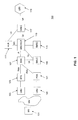
- FIG. 1 is an illustration of an exemplary architectural diagram for a communications system.
- a mobile station or mobile device 101 may be in communication with a BTS 105 via a wireless interface Um.
- the base station controller (“BSC”) 107 manages radio resources including the BTS 105 via an Abis interface.
- the Abis interface is generally an open interface defined as part of the ETSI specification for GSM and carries call set up information, including voice channel assignments between the BSC 107 and BTS 105 .
- a Mobile switching center/visitor location register (“MSC/VLR”) 113 may coordinate between the mobile appliance communication network and a global mobile location center (“GMLC”) 117 .
- GMLC global mobile location center
- one or more location measurement units (“LMUs”) 103 may be operably connected to a PDE 121 or BTS 105 which may also be operably connected to the BSC 107 via the Abis wire line interface.
- the LMUs 103 may make measurements on the RF signals of the Um interface, along with other measurements to support one or more of the positioning methods well known in the art.
- the measurements from the LMUs may be provided to a servicing mobile location center (“SMLC”) 109 via the BSC 107 where the location of the mobile device 101 may be determined.
- SMLC servicing mobile location center
- the SMLC 109 may also be operably connected to the MSC/VLR 113 via an Ls interface.
- the GMLC 117 may be connected to a home location register (“HLR”) 111 over an Lh interface and the MSC/VLR 113 over an Lg interface.
- HLR home location register
- LBS location based services
- a global mobile switching center (“GMSC”) 115 may also be operably connected to the MSC/VLR 113 .
- exemplary communication links that establish a path from the BSC 107 to the SMLC 109 are the “A” and “Ls” interfaces. These interfaces generally carry digital traffic over an SS7 connection which may be physically carried by some number of T1 style communication links in the underlying wired telecommunications network.
- a and Ls interfaces In the event that NMR location is needed for a wireless provider, there may potentially be a substantial increase in the amount of data that the A and Ls interfaces must support. While expansion of the capacity of these interfaces is an option for resolving the problem, this may be a very expensive solution for a wireless carrier to support, given that the solution may require a significant nationwide capacity increase. Therefore, there is a need in the art to implement alternative communication methods for which NMR location could be supported in a wireless network that would not substantially increase implementation and operational costs.
- NMRs Network Measurement Reports
- an embodiment of the present subject matter provides a method for determining an approximate location of a mobile device.
- the method may comprise the steps of determining at a first node of a network the occurrence of a predetermined event and storing at a second node of the network measurement data associated with the mobile device.
- One or more attempts may be made to determine a location of the mobile device using a first location methodology.
- mobile device data may be received at a third node of the network from the second node.
- An approximate location of the mobile device using the mobile device data may then be determined at the third node.
- the method may comprise sending the determined approximate location to a fourth node of the network.
- the system may comprise circuitry for determining at a first node of a network the occurrence of a predetermined event, and a database at a second node of the network for storing data associated with the mobile device.
- the system may also comprise a processor for attempting to determine a location of the mobile device, and a receiver at a third node of the network for receiving the mobile device data from the second node upon failure of the location attempt.
- the system may include circuitry for determining at the third node an approximate location of the mobile device using the mobile device data.
- the system may further comprise circuitry for sending the determined approximate location to a fourth node of the network.
- FIG. 1 is an illustration of an exemplary architectural diagram for a communications system.
- FIG. 2 is an algorithm according to one embodiment of the present subject matter.
- FIG. 3 is a block diagram of a system according to one embodiment of the present subject matter.
- GPS Global Positioning System
- GLONASS Russian satellite navigation system
- QZSS Japanese Quasi-Zenith Satellite System
- Beidou Chinese satellite navigation and positioning system
- TTFF time to first fix
- exemplary network elements that supply the assistance data may be a Mobile Location Center (“MLC”) or other comparable network element.
- MLC Mobile Location Center
- Typical A-GPS information may include data for determining a GPS receiver's approximate position, time synchronization mark, satellite ephemerides, and satellite dopplers. Different A-GPS services may omit some of these parameters; however, another component of the supplied information is the identification of the satellites for which a device or GPS receiver should search.
- the MLC generally determines this information utilizing an approximate location of the device.
- this approximate location may be the location of the cell tower serving the device or another location such as, but not limited to, the boundary of the network, a city, county, state, country, continent, etc.
- the MLC may then supply the device with the appropriate A-GPS assistance data for the set of satellites in view from this conventional location.
- the system and/or method of the present subject matter may also generally refer to a Network Measurement Report (“NMR”) that may contain measurement data or calibration data obtained using various known methods.
- NMR Network Measurement Report
- the measurement data or calibration data may be obtained at each of several calibration points, which may be discrete points within a region each having geographical coordinates (e.g., latitude and longitude) associated therewith.
- Exemplary data may include, but are not limited to: (a) signal strengths observed for signals transmitted by a set of transmitters of known location within or in proximity to a region R; (b) signal strength of a transmitter located at the calibration point as measured by a set of receivers of known location within or in proximity to the region R; (c) round trip time for a signal between the calibration point and an external known point; (d) time difference of arrival at the calibration point with respect pairs of external points located within or in proximity to the region R as measured by either a receiver at the calibration point or the external points; (e) the serving cell or sector for a mobile wireless device operating at that calibration point; (f) the network state at the time of collection (e.g., a finite number of such states may be required to distinguish between network conditions that vary diurnally, weekly or in some other manner); and (g) combinations of the above.
- the case in (a) may apply to the Integrated Digital Enhanced Network (“IDEN”) specification
- (c) may apply to the Global System for Mobile communications (“GSM”) specification as in the Timing Advance (“TA”) parameter or the Round Trip Time (“RTT”) parameter in the Universal Mobile Telecommunications System (“UMTS”) specification
- (d) may apply to the UMTS specification
- the external receivers may be the base stations.
- GSM Global System for Mobile communications
- TA Timing Advance
- RTT Round Trip Time
- UMTS Universal Mobile Telecommunications System
- the measurement or calibration data may be any of those measurements made by a mobile wireless device or any measurement made on the transmissions or characteristics of the mobile wireless device at a set of external transmitter/receivers in the region R or in proximity thereto.
- Embodiments of the present subject matter may also find applicability as a fallback location method or system to another primary location means for locating a mobile device.
- an exemplary wireless network may rely upon an A-GPS technique for its primary positioning technology.
- NMR location may be a suitable backup method.
- Embodiments of the present subject matter may thus provide a novel mechanism for which NMR data would be collected by the network that guarantees availability of the secondary NMR location estimate if needed, yet having a slight impact upon the underlying communications bandwidths within the exemplary network.
- a base station controller (“BSC”) 107 may, upon detecting that an emergency call has been made, begin to locally cache or store NMR data associated with a target mobile device 101 .
- NMR data may be retrieved from the target mobile device 101 at a configurable, periodic or random rate, and may be stored within the BSC 107 memory or database for a configurable period of time (e.g., 30 seconds, 1 minute, less than or greater than one minute, etc.).
- the respective servicing mobile location center (“SMLC”) 109 may then be requested to perform a location of the target mobile device 101 and may initiate a procedure to locate the mobile device 101 .
- the SMLC 109 may initially attempt to locate the mobile device 101 placing the emergency call through a primary location means, such as, but not limited to, A-GPS. In another embodiment of the present subject matter, subsequent location attempts may also be conducted.
- a secondary location method would be invoked.
- the secondary location method may be concurrently invoked with the initial location attempt using the first location methodology or with subsequent location attempts.
- the number of attempts to locate the device using the first location methodology may be configurable.
- subsequent location attempts may utilize any one of, combinations of, or hybrid location methodologies well known in the art, and such subsequent location attempts may use the same or different location methodologies as utilized in the initial location attempt.
- Exemplary embodiments of the present subject matter may implement the secondary location method by having the SMLC 109 request the BSC 107 to send cached NMR data to the SMLC 109 .
- the SMLC 109 upon receiving the NMR data, may then generate a backup location estimate and pass the estimate to the network entity initiating the location request.
- many variations of the aforementioned process may be implemented that would provide the ability to cache the NMR data inside the core communications network until the SMLC 109 , or a positioning determining entity (“PDE”) 121 , requires the NMR data to be sent.
- the NMR data stored in the respective network may be provided to the SMLC 109 or PDE 121 in the event that a primary location mechanism fails to thereby minimize traffic loading on the communications path between the core network and the SMLC 109 or PDE 121 .
- the NMR caching function may be stored in other network elements such as the Mobile Switching Center (“MSC”) 113 or the base transceiver stations (“BTS”) 105 , and the example provided above should not limit the scope of the claims appended herewith.
- FIG. 2 is an algorithm according to one embodiment of the present subject matter.
- a method for determining the location of a wireless device 200 is provided.
- the occurrence of a predetermined event may be determined at a first node of a communications network.
- An exemplary communications network may be, but is not limited to, a wireless communication network such as a GSM network, iDEN, Worldwide Interoperability for Microwave Access (“WiMAX”) Network, UMTS Network, Code Division Multiple Access (“CDMA”) 2000 Network, WiFi Network, and Long Term Evolution (“LTE”) Network.
- An exemplary first node may be, but is not limited to, a BSC, BTS, MSC, SMLC, PDE, and combinations thereof.
- An exemplary predetermined event may be, but is not limited to, an emergency call, a 911 call, a request for location of the mobile device, and combinations thereof.
- measurement data associated with the mobile device may be stored at a second node of the network.
- An exemplary second node may be, but is not limited to, a BSC, BTS, MSC, SMLC, PDE, and combinations thereof.
- the first and second nodes may be the same.
- Exemplary data may include, by way of a non-limiting example, NMR information.
- exemplary measurement data associated with the mobile may include signal strength for a signal transmitted by a transmitter having a known location, signal strength of a signal transmitted by a transmitter and received by a receiver at a known location, network timing measurements, round trip propagation time measurements, timing advance, time difference of arrival, the identification of a serving cell serving said mobile device, the identification of a serving sector serving said mobile device, a state of a wireless network serving said mobile device, and combinations thereof.
- the storing of the data at the second node may only occur after the determination of the occurrence of the predetermined event.
- the data may be stored for a predetermined and/or configurable duration of time, such as, but not limited to, less than one minute.
- step 230 may further comprise initially or concurrently attempting to determine a location of the mobile device using a first location methodology including GPS information or A-GPS information.
- mobile device data from the second node may be received at a third node of the network at step 240 .
- An exemplary third node may be, but is not limited to, a SMLC or PDE.
- an approximate location of the mobile device may then be determined at the third node using the mobile device data.
- the method may include, at step 260 , sending the determined approximate location to a fourth node of the network.
- FIG. 3 is a block diagram of a system according to one embodiment of the present subject matter.
- the system may include, as represented by block 310 , circuitry for determining at a first node of a network the occurrence of a predetermined event.
- An exemplary communications network may be, but is not limited to, a wireless communication network such as a GSM network, iDEN, WiMAX Network, UMTS Network, CDMA 2000 Network, WiFi Network, and LTE Network.
- An exemplary first node may be, but is not limited to, a BSC, BTS, MSC, SMLC, PDE, and combinations thereof.
- An exemplary predetermined event may be, but is not limited to, an emergency call, a 911 call, a request for location of the mobile device, and combinations thereof.
- the system may include a database at a second node of the network for storing data associated with the mobile device.
- An exemplary second node may be, but is not limited to, a BSC, BTS, MSC, SMLC, PDE, and combinations thereof.
- the first and second nodes may be the same.
- Exemplary data may include, by way of a non-limiting example, NMR information.
- exemplary measurement data associated with the mobile device may include signal strength for a signal transmitted by a transmitter having a known location, signal strength of a signal transmitted by a transmitter and received by a receiver at a known location, network timing measurements, round trip propagation time measurements, timing advance, time difference of arrival, the identification of a serving cell serving said mobile device, the identification of a serving sector serving said mobile device, a state of a wireless network serving said mobile device, and combinations thereof.
- the database at the second node may store the data only after the determination of the occurrence of the predetermined event.
- the data may be stored for a predetermined and/or configurable duration of time, such as, but not limited to, less than one minute.
- the system may also include, as represented by block 330 , a processor for attempting to determine a location of the mobile device.
- the processor may further comprise circuitry for initially or concurrently attempting to determine a location of the mobile device using a first location methodology including GPS information or A-GPS information.
- the system may include a receiver at a third node of the network for receiving the mobile device data from the second node upon failure of the location attempt.
- An exemplary third node may be, but is not limited to, a SMLC or PDE.
- the system may additionally include, at block 350 , circuitry for determining at the third node an approximate location of the mobile device using the mobile device data.
- the system may include, as represented by block 360 , circuitry for sending the determined approximate location to a fourth node of the network.
- Another aspect of embodiments of the present subject matter may take advantage of the communications infrastructure already existing between the SMLC and BSC to serve the secondary purpose of supporting the transport of the NMR data for a backup location mechanism. Therefore, embodiments of the present subject matter would not require a new dedicated interface to be designed or developed between the BSC and SMLC, or between the BSC and PDE.
- An additional aspect of embodiments of the present subject matter may thus provide a method to minimize implementation cost of a location system. It is also an aspect of embodiments of the present subject matter to provide a backup location system or a system providing a fairly low usage rate compared to the subscriber density of a communications network. It is yet another aspect of embodiments of the present subject matter to provide wireless carriers an opportunity to implement a secondary location mechanism with minimal incremental cost and complexity through an intelligent use of signaling and utilization of an existing communications infrastructure.
- FIGS. 1-3 As shown by the various configurations and embodiments illustrated in FIGS. 1-3 , a method and system for network measurement report caching for location of mobile devices have been described.
Abstract
Description
Claims (38)
Priority Applications (2)
| Application Number | Priority Date | Filing Date | Title |
|---|---|---|---|
| US12/113,476 US8213955B2 (en) | 2008-05-01 | 2008-05-01 | Network measurement report caching for location of mobile devices |
| PCT/US2009/042482 WO2009135103A1 (en) | 2008-05-01 | 2009-05-01 | Network measurement report caching for location of mobile devices |
Applications Claiming Priority (1)
| Application Number | Priority Date | Filing Date | Title |
|---|---|---|---|
| US12/113,476 US8213955B2 (en) | 2008-05-01 | 2008-05-01 | Network measurement report caching for location of mobile devices |
Publications (2)
| Publication Number | Publication Date |
|---|---|
| US20090275344A1 US20090275344A1 (en) | 2009-11-05 |
| US8213955B2 true US8213955B2 (en) | 2012-07-03 |
Family
ID=41036769
Family Applications (1)
| Application Number | Title | Priority Date | Filing Date |
|---|---|---|---|
| US12/113,476 Active 2031-05-04 US8213955B2 (en) | 2008-05-01 | 2008-05-01 | Network measurement report caching for location of mobile devices |
Country Status (2)
| Country | Link |
|---|---|
| US (1) | US8213955B2 (en) |
| WO (1) | WO2009135103A1 (en) |
Cited By (2)
| Publication number | Priority date | Publication date | Assignee | Title |
|---|---|---|---|---|
| US20140307575A1 (en) * | 2011-11-16 | 2014-10-16 | Telecommunication Systems, Inc. | Enhancing a-gps location accuracy and yield with location measurement units and network timing measurements |
| US20150327018A1 (en) * | 2012-06-20 | 2015-11-12 | Telefonaktiebolaget L M Ericsson (Publ) | Method and Network Node for Enabling Position Determination of a User Equipment Measurement |
Families Citing this family (13)
| Publication number | Priority date | Publication date | Assignee | Title |
|---|---|---|---|---|
| US20080299994A1 (en) * | 2007-06-01 | 2008-12-04 | Motorola, Inc. | System and Method for Location Determination for Mobile Clients |
| US8693955B2 (en) * | 2008-01-31 | 2014-04-08 | ShaoWei Pan | Method and apparatus for determining the location of a node in a wireless system |
| US20090197613A1 (en) * | 2008-01-31 | 2009-08-06 | Motorola, Inc. | Method and apparatus for determining the location of a node in a wireless system |
| US8509746B1 (en) * | 2009-09-24 | 2013-08-13 | Sprint Communications Company L.P. | Customer care using handset data for diagnostics |
| US8566022B1 (en) | 2010-02-09 | 2013-10-22 | Google Inc. | Managing use of location-identification services |
| US9277384B2 (en) | 2010-12-18 | 2016-03-01 | Telefonaktiebolaget L M Ericsson (Publ) | Methods and apparatus for communicating location information for enhancing emergency positioning |
| US8576756B2 (en) | 2011-06-28 | 2013-11-05 | International Business Machines Corporation | Continuous cache service in cellular networks |
| US20130150002A1 (en) * | 2011-10-21 | 2013-06-13 | Point Inside, Inc. | Identify a Radio Frequency Device by MAC Address System and Method |
| US20130281062A1 (en) * | 2011-10-21 | 2013-10-24 | Point Inside, Inc. | Identify a radio frequency device by mac address system and method |
| US9121922B2 (en) * | 2012-06-26 | 2015-09-01 | Cambridge Silicon Radio Limited | Access point location identification methods and apparatus based on absolute and relative harvesting |
| US8909258B2 (en) | 2012-09-07 | 2014-12-09 | Cambridge Silicon Radio Limited | Context and map aiding for self-learning |
| US8918117B2 (en) * | 2012-12-12 | 2014-12-23 | Intel Corporation | Apparatus, system and method of estimating a location of a mobile device |
| US9078131B2 (en) * | 2013-05-05 | 2015-07-07 | Intel IP Corporation | Apparatus, system and method of communicating location-enabling information for location estimation |
Citations (122)
| Publication number | Priority date | Publication date | Assignee | Title |
|---|---|---|---|---|
| US3150372A (en) | 1959-06-23 | 1964-09-22 | Motorola Inc | Computing system |
| US3659085A (en) | 1970-04-30 | 1972-04-25 | Sierra Research Corp | Computer determining the location of objects in a coordinate system |
| US4728959A (en) | 1986-08-08 | 1988-03-01 | Ventana Sciences Inc. | Direction finding localization system |
| US4814751A (en) | 1987-02-27 | 1989-03-21 | Wildlife Materials, Inc. | Patient tracking system |
| US4845504A (en) | 1987-04-08 | 1989-07-04 | M/A-Com, Inc. | Mobile radio network for nationwide communications |
| US4891650A (en) | 1988-05-16 | 1990-01-02 | Trackmobile Inc. | Vehicle location system |
| US5056106A (en) | 1990-08-02 | 1991-10-08 | Wang James J | Golf course ranging and direction-finding system using spread-spectrum radiolocation techniques |
| US5218618A (en) | 1990-11-07 | 1993-06-08 | Hughes Aircraft Company | Cellular telephone service using spread spectrum transmission |
| US5245634A (en) | 1992-03-23 | 1993-09-14 | Motorola, Inc. | Base-site synchronization in a communication system |
| US5317323A (en) | 1993-03-05 | 1994-05-31 | E-Systems, Inc. | Passive high accuracy geolocation system and method |
| US5327144A (en) | 1993-05-07 | 1994-07-05 | Associated Rt, Inc. | Cellular telephone location system |
| US5365544A (en) | 1990-12-05 | 1994-11-15 | Interdigital Technology Corporation | CDMA communications and geolocation system and method |
| US5372144A (en) | 1992-12-01 | 1994-12-13 | Scimed Life Systems, Inc. | Navigability improved guidewire construction and method of using same |
| US5404376A (en) | 1993-09-09 | 1995-04-04 | Ericsson-Ge Mobile Communications Inc. | Navigation assistance for call handling in mobile telephone systems |
| US5423067A (en) | 1991-09-09 | 1995-06-06 | Nec Corporation | Digital mobile communications system and method for providing intensity/coverage reference maps using base stations and mobile stations |
| US5465289A (en) | 1993-03-05 | 1995-11-07 | E-Systems, Inc. | Cellular based traffic sensor system |
| US5506863A (en) | 1993-08-25 | 1996-04-09 | Motorola, Inc. | Method and apparatus for operating with a hopping control channel in a communication system |
| US5506864A (en) | 1990-12-05 | 1996-04-09 | Interdigital Technology Corporation | CDMA communications and geolocation system and method |
| US5508708A (en) | 1995-05-08 | 1996-04-16 | Motorola, Inc. | Method and apparatus for location finding in a CDMA system |
| US5512908A (en) | 1994-07-08 | 1996-04-30 | Lockheed Sanders, Inc. | Apparatus and method for locating cellular telephones |
| US5515419A (en) | 1992-06-01 | 1996-05-07 | Trackmobile | Tracking system and method for tracking a movable object carrying a cellular phone unit, and integrated personal protection system incorporating the tracking system |
| US5519760A (en) | 1994-06-22 | 1996-05-21 | Gte Laboratories Incorporated | Cellular network-based location system |
| US5592180A (en) | 1992-08-20 | 1997-01-07 | Nexus1994 Limited | Direction finding and mobile location system for trunked mobile radio systems |
| US5614914A (en) | 1994-09-06 | 1997-03-25 | Interdigital Technology Corporation | Wireless telephone distribution system with time and space diversity transmission for determining receiver location |
| US5675344A (en) | 1996-06-28 | 1997-10-07 | Motorola, Inc. | Method and apparatus for locating a mobile station in a spread spectrum communication system |
| US5815538A (en) | 1993-06-25 | 1998-09-29 | Omniplex, Inc. | Method and apparatus for determining location of a subscriber device in a wireless cellular communications system |
| US5825887A (en) | 1995-12-28 | 1998-10-20 | Trimble Navigation Limited | Transmitting and receiving apparatus for full code correlation operation under encryption for satellite positioning system |
| US5870029A (en) | 1996-07-08 | 1999-02-09 | Harris Corporation | Remote mobile monitoring and communication system |
| US5920278A (en) | 1997-05-28 | 1999-07-06 | Gregory D. Gibbons | Method and apparatus for identifying, locating, tracking, or communicating with remote objects |
| US5952969A (en) | 1997-08-18 | 1999-09-14 | Telefonakiebolaget L M Ericsson (Publ) | Method and system for determining the position of mobile radio terminals |
| US5959580A (en) | 1994-11-03 | 1999-09-28 | Ksi Inc. | Communications localization system |
| US5960341A (en) | 1994-09-28 | 1999-09-28 | U S West, Inc. | Positioning system having an RF-measurements databank |
| US5973643A (en) | 1997-04-11 | 1999-10-26 | Corsair Communications, Inc. | Method and apparatus for mobile emitter location |
| US5987329A (en) | 1997-07-30 | 1999-11-16 | Ericsson Inc | System and method for mobile telephone location measurement using a hybrid technique |
| US6014102A (en) | 1998-04-17 | 2000-01-11 | Motorola, Inc. | Method and apparatus for calibrating location finding equipment within a communication system |
| US6047192A (en) | 1996-05-13 | 2000-04-04 | Ksi Inc. | Robust, efficient, localization system |
| US6091362A (en) | 1999-01-08 | 2000-07-18 | Trueposition, Inc. | Bandwidth synthesis for wireless location system |
| US6097959A (en) | 1998-01-29 | 2000-08-01 | Ericsson Inc. | System and method for accurate positioning of mobile terminals |
| US6101178A (en) | 1997-07-10 | 2000-08-08 | Ksi Inc. | Pseudolite-augmented GPS for locating wireless telephones |
| US6108555A (en) | 1996-05-17 | 2000-08-22 | Ksi, Inc. | Enchanced time difference localization system |
| US6144711A (en) | 1996-08-29 | 2000-11-07 | Cisco Systems, Inc. | Spatio-temporal processing for communication |
| US6188351B1 (en) | 1998-08-13 | 2001-02-13 | Ericsson Inc. | Method for improving signal acquistion in a global positioning system receiver |
| US6191738B1 (en) | 1999-09-30 | 2001-02-20 | Motorola, Inc. | Method and apparatus for locating a remote unit within a communication system |
| US6201803B1 (en) | 1995-05-02 | 2001-03-13 | British Telecommunications Public Limited Company | Cellular radio location system |
| US6201499B1 (en) | 1998-02-03 | 2001-03-13 | Consair Communications | Time difference of arrival measurement system |
| US6212319B1 (en) | 1997-11-27 | 2001-04-03 | Dassault Electronique | Electro-optical device, notably for optical distribution |
| US6233459B1 (en) | 1997-04-10 | 2001-05-15 | The Atlantis Company, Limited, Japan | System for providing Geolocation of a mobile transceiver |
| US6246884B1 (en) | 1998-08-19 | 2001-06-12 | Sigmaone Communications Corporation | System and method for measuring and locating a mobile station signal in a wireless communication system |
| US6295455B1 (en) | 1999-06-11 | 2001-09-25 | Telefonaktiebolaget Lm Ericsson (Publ) | Methods and arrangements for locating a mobile telecommunications station |
| US6311043B1 (en) | 1998-10-27 | 2001-10-30 | Siemens Aktiengesellschaft | Method and measurement configuration for measuring the characteristics of radio channels |
| US6334059B1 (en) | 1999-01-08 | 2001-12-25 | Trueposition, Inc. | Modified transmission method for improving accuracy for e-911 calls |
| US6366241B2 (en) | 2000-06-26 | 2002-04-02 | Trueposition, Inc. | Enhanced determination of position-dependent signal characteristics of a wireless transmitter |
| US6388618B1 (en) | 1999-01-08 | 2002-05-14 | Trueposition, Inc. | Signal collection system for a wireless location system |
| US6407703B1 (en) | 2000-08-07 | 2002-06-18 | Lockheed Martin Corporation | Multi-platform geolocation method and system |
| US6463290B1 (en) | 1999-01-08 | 2002-10-08 | Trueposition, Inc. | Mobile-assisted network based techniques for improving accuracy of wireless location system |
| US6470195B1 (en) | 2000-10-31 | 2002-10-22 | Raytheon Company | Method and apparatus for modeling a smart antenna in a network planning tool |
| US6477161B1 (en) | 1998-12-21 | 2002-11-05 | Nortel Networks Limited | Downlink beamforming approach for frequency division duplex cellular systems |
| US20020175855A1 (en) | 2001-05-24 | 2002-11-28 | Richton Robert E. | Autonomous calibration of a wireless-global positioning system |
| US6501955B1 (en) | 2000-06-19 | 2002-12-31 | Intel Corporation | RF signal repeater, mobile unit position determination system using the RF signal repeater, and method of communication therefor |
| US6553322B1 (en) | 1999-09-29 | 2003-04-22 | Honeywell International Inc. | Apparatus and method for accurate pipeline surveying |
| US6571082B1 (en) | 1999-10-29 | 2003-05-27 | Verizon Laboratories Inc. | Wireless field test simulator |
| US20030134646A1 (en) * | 2002-01-16 | 2003-07-17 | Tim Forrester | Systems and methods for transmitting global positioning system information from a wireless communication system base station |
| US20030139188A1 (en) | 2002-01-24 | 2003-07-24 | Chen Byron Hua | Geolocation using enhanced timing advance techniques |
| US6603761B1 (en) | 1999-09-17 | 2003-08-05 | Lucent Technologies Inc. | Using internet and internet protocols to bypass PSTN, GSM map, and ANSI-41 networks for wireless telephone call delivery |
| US20030190919A1 (en) | 2000-08-22 | 2003-10-09 | Jarko Niemenmaa | Method for positioning a mobile station |
| US6640106B2 (en) | 2001-09-20 | 2003-10-28 | Motorola, Inc. | Method and system for verifying the position of a mobile station using checkpoints |
| US20030203738A1 (en) | 2002-04-29 | 2003-10-30 | Brown Larry Michael | Method and apparatus for locating a remote unit within a communication system |
| US6646604B2 (en) | 1999-01-08 | 2003-11-11 | Trueposition, Inc. | Automatic synchronous tuning of narrowband receivers of a wireless location system for voice/traffic channel tracking |
| US20040043775A1 (en) | 2002-08-29 | 2004-03-04 | Kennedy Joseph P. | Tasking and reporting method and implementation for wireless appliance location systems |
| US20040132466A1 (en) | 2002-12-23 | 2004-07-08 | Kennedy Joseph P. | Method and apparatus for supporting multiple wireless carrier mobile station location requirements with a common network overlay location system |
| US6765531B2 (en) | 1999-01-08 | 2004-07-20 | Trueposition, Inc. | System and method for interference cancellation in a location calculation, for use in a wireless location system |
| US6771969B1 (en) | 2000-07-06 | 2004-08-03 | Harris Corporation | Apparatus and method for tracking and communicating with a mobile radio unit |
| US6782264B2 (en) | 1999-01-08 | 2004-08-24 | Trueposition, Inc. | Monitoring of call information in a wireless location system |
| US20040192346A1 (en) * | 2003-03-27 | 2004-09-30 | Henry Chang | Location capable mobile handset |
| US20040198386A1 (en) | 2002-01-16 | 2004-10-07 | Dupray Dennis J. | Applications for a wireless location gateway |
| US20040203921A1 (en) | 2003-03-21 | 2004-10-14 | Nicholas Bromhead | Sub-sector timing advance positions determinations |
| US20040218664A1 (en) | 2003-01-31 | 2004-11-04 | Kennedy Joseph P. | Method for angle of arrival determination on frequency hopping air interfaces |
| US20040252752A1 (en) | 2003-01-31 | 2004-12-16 | Kennedy Joseph P. | Method for calibrating an AOA location system for frequency hopping air interfaces |
| US6834234B2 (en) | 2000-11-22 | 2004-12-21 | Trimble Navigation, Limited | AINS land surveyor system with reprocessing, AINS-LSSRP |
| US6845240B2 (en) | 2000-12-11 | 2005-01-18 | Grayson Wireless | System and method for analog cellular radio geolocation |
| US6859172B2 (en) | 2003-02-17 | 2005-02-22 | Global Business Software Development Technologies, Inc. | System and method for locating a mobile phone |
| US20050058182A1 (en) | 2003-01-31 | 2005-03-17 | Kennedy Joseph P. | Method for calibrating an AOA location system for all frequencies in a frequency hopping signal |
| US6871077B2 (en) | 2001-10-09 | 2005-03-22 | Grayson Wireless | System and method for geolocating a wireless mobile unit from a single base station using repeatable ambiguous measurements |
| US20050066044A1 (en) | 2003-06-30 | 2005-03-24 | Hemant Chaskar | IP-based location service within code division multiple access network |
| US6873290B2 (en) | 1999-01-08 | 2005-03-29 | Trueposition, Inc. | Multiple pass location processor |
| US6876859B2 (en) | 2001-07-18 | 2005-04-05 | Trueposition, Inc. | Method for estimating TDOA and FDOA in a wireless location system |
| US20050136945A1 (en) | 2003-12-19 | 2005-06-23 | Kennedy Joseph P. | E-OTD augmentation to U-TDOA location system |
| US6920329B2 (en) | 2001-01-16 | 2005-07-19 | Allen Telecom | Method and system for applying wireless geolocation technology |
| US20050159170A1 (en) | 2004-01-16 | 2005-07-21 | Gagan Puranik | Method and system for transmitting assistance location data for fleet and asset management |
| US6922170B2 (en) | 2002-01-24 | 2005-07-26 | Motorola, Inc. | Methods and apparatus for determining a direction of arrival in a wireless communication system |
| US20050192026A1 (en) | 2003-06-04 | 2005-09-01 | Carlson John P. | System and method for CDMA geolocation |
| US6952158B2 (en) | 2000-12-11 | 2005-10-04 | Kennedy Jr Joseph P | Pseudolite positioning system and method |
| US20060003775A1 (en) | 1999-01-08 | 2006-01-05 | Bull Jeffrey F | Advanced triggers for location-based service applications in a wireless location system |
| US20060003695A1 (en) | 2002-10-16 | 2006-01-05 | Kennedy Joseph P Jr | System and method of operation for network overlay geolocation systemwith repeaters |
| US6987979B2 (en) | 2001-12-22 | 2006-01-17 | Telefonaktiebolaget Lm Ericsson (Publ) | Locating packet-switched mobile terminals using network initiated artificial cell hops |
| US20060014517A1 (en) | 2004-07-13 | 2006-01-19 | Barclay Deborah L | Method and apparatus for providing network support for a wireless emergency call |
| US6996392B2 (en) | 2002-09-03 | 2006-02-07 | Trueposition, Inc. | E911 overlay solution for GSM, for use in a wireless location system |
| US20060028338A1 (en) | 2003-03-21 | 2006-02-09 | Baldev Krishan | Asset tracking apparatus and method |
| US20060116130A1 (en) | 2002-10-16 | 2006-06-01 | Andrew Corporation | Network overlay location system and method for air interface with frequency stopping |
| WO2006088472A1 (en) | 2005-02-11 | 2006-08-24 | Trueposition, Inc. | Base transceiver station (bts) synchronization |
| US20060240836A1 (en) | 2003-03-03 | 2006-10-26 | Kennedy Joseph P Jr | Independently acquiring and tracking wireless communication system signaling channel assignments on communication links |
| US20070042790A1 (en) | 2000-07-14 | 2007-02-22 | Norman Mohi | Locating system and method |
| US20070072583A1 (en) | 2005-09-23 | 2007-03-29 | University Of South Florida | Emergency Reporting System |
| US20070087689A1 (en) | 2003-09-26 | 2007-04-19 | Martin Alles | System and method of operation for network overlay geolocation system with repeaters using am golay hadamard signatures |
| US20070111746A1 (en) | 2005-11-16 | 2007-05-17 | Anderson Robert J | Transmit-power control for wireless mobile services |
| US20070155489A1 (en) | 2005-12-30 | 2007-07-05 | Frederic Beckley | Device and network enabled geo-fencing for area sensitive gaming enablement |
| US20070155401A1 (en) | 2005-12-30 | 2007-07-05 | Trueposition Inc. | User plane uplink time difference of arrival (u-tdoa) |
| US20070202885A1 (en) | 2003-06-24 | 2007-08-30 | Kennedy Joseph P Jr | Method For Sparse Network Deployment Accuracy Enhancements |
| US20080132247A1 (en) | 2006-12-01 | 2008-06-05 | Trueposition, Inc. | System for automatically determining cell transmitter parameters to facilitate the location of wireless devices |
| US20080132244A1 (en) | 2006-12-01 | 2008-06-05 | Trueposition, Inc. | Subscriptionless location of wireless devices |
| US20080137524A1 (en) | 2006-12-12 | 2008-06-12 | Trueposition, Inc. | Location of Wideband OFDM Transmitters With Limited Receiver Bandwidth |
| US20080160952A1 (en) | 2006-12-28 | 2008-07-03 | Trueposition, Inc. | Emergency wireless location system including a location determining receiver |
| US20080160953A1 (en) | 2006-12-28 | 2008-07-03 | Trueposition, Inc. | Emergency wireless location system including a wireless transceiver |
| US20080158059A1 (en) | 2006-12-27 | 2008-07-03 | Trueposition, Inc. | Portable, iterative geolocation of RF emitters |
| US7427952B2 (en) | 2005-04-08 | 2008-09-23 | Trueposition, Inc. | Augmentation of commercial wireless location system (WLS) with moving and/or airborne sensors for enhanced location accuracy and use of real-time overhead imagery for identification of wireless device locations |
| US20080248811A1 (en) | 2003-12-30 | 2008-10-09 | Trueposition, Inc. | TDOA/GPS Hybrid Wireless Location System |
| US20080261614A1 (en) | 2007-04-18 | 2008-10-23 | Mia Rashidus S | Sparsed U-TDOA Wireless Location Networks |
| US20080261611A1 (en) | 2007-04-18 | 2008-10-23 | Mia Rashidus S | Sparsed U-TDOA Wireless Location Networks |
| US20080261612A1 (en) | 2007-04-18 | 2008-10-23 | Mia Rashidus S | Sparsed U-TDOA Wireless Location Networks |
| US20080261613A1 (en) | 2007-04-18 | 2008-10-23 | Anderson Robert J | Sparsed U-TDOA Wireless Location Networks |
| US20090005061A1 (en) | 2005-12-30 | 2009-01-01 | Trueposition, Inc. | Location quality of service indicator |
| US7593738B2 (en) | 2005-12-29 | 2009-09-22 | Trueposition, Inc. | GPS synchronization for wireless communications stations |
Family Cites Families (2)
| Publication number | Priority date | Publication date | Assignee | Title |
|---|---|---|---|---|
| KR100869457B1 (en) * | 2003-11-26 | 2008-11-19 | 퀄컴 인코포레이티드 | Method and apparatus for calculating a position estimate of a mobile station using network information |
| US8165606B2 (en) * | 2005-12-22 | 2012-04-24 | Kyocera Corporation | Apparatus, system, and method for location information management in a portable communication device |
-
2008
- 2008-05-01 US US12/113,476 patent/US8213955B2/en active Active
-
2009
- 2009-05-01 WO PCT/US2009/042482 patent/WO2009135103A1/en active Application Filing
Patent Citations (162)
| Publication number | Priority date | Publication date | Assignee | Title |
|---|---|---|---|---|
| US3150372A (en) | 1959-06-23 | 1964-09-22 | Motorola Inc | Computing system |
| US3659085A (en) | 1970-04-30 | 1972-04-25 | Sierra Research Corp | Computer determining the location of objects in a coordinate system |
| US4728959A (en) | 1986-08-08 | 1988-03-01 | Ventana Sciences Inc. | Direction finding localization system |
| US4814751A (en) | 1987-02-27 | 1989-03-21 | Wildlife Materials, Inc. | Patient tracking system |
| US4845504A (en) | 1987-04-08 | 1989-07-04 | M/A-Com, Inc. | Mobile radio network for nationwide communications |
| US4891650A (en) | 1988-05-16 | 1990-01-02 | Trackmobile Inc. | Vehicle location system |
| US5056106A (en) | 1990-08-02 | 1991-10-08 | Wang James J | Golf course ranging and direction-finding system using spread-spectrum radiolocation techniques |
| US5218618A (en) | 1990-11-07 | 1993-06-08 | Hughes Aircraft Company | Cellular telephone service using spread spectrum transmission |
| US5365544A (en) | 1990-12-05 | 1994-11-15 | Interdigital Technology Corporation | CDMA communications and geolocation system and method |
| US5506864A (en) | 1990-12-05 | 1996-04-09 | Interdigital Technology Corporation | CDMA communications and geolocation system and method |
| US5423067A (en) | 1991-09-09 | 1995-06-06 | Nec Corporation | Digital mobile communications system and method for providing intensity/coverage reference maps using base stations and mobile stations |
| US5245634A (en) | 1992-03-23 | 1993-09-14 | Motorola, Inc. | Base-site synchronization in a communication system |
| US5515419A (en) | 1992-06-01 | 1996-05-07 | Trackmobile | Tracking system and method for tracking a movable object carrying a cellular phone unit, and integrated personal protection system incorporating the tracking system |
| US5592180A (en) | 1992-08-20 | 1997-01-07 | Nexus1994 Limited | Direction finding and mobile location system for trunked mobile radio systems |
| US5372144A (en) | 1992-12-01 | 1994-12-13 | Scimed Life Systems, Inc. | Navigability improved guidewire construction and method of using same |
| US5317323A (en) | 1993-03-05 | 1994-05-31 | E-Systems, Inc. | Passive high accuracy geolocation system and method |
| US5465289A (en) | 1993-03-05 | 1995-11-07 | E-Systems, Inc. | Cellular based traffic sensor system |
| US5559864A (en) | 1993-03-05 | 1996-09-24 | E-Systems, Inc. | Cellular based traffic sensor system |
| US5608410A (en) | 1993-05-07 | 1997-03-04 | Associated Rt, Inc. | System for locating a source of bursty transmissions cross reference to related applications |
| US5327144A (en) | 1993-05-07 | 1994-07-05 | Associated Rt, Inc. | Cellular telephone location system |
| US5815538A (en) | 1993-06-25 | 1998-09-29 | Omniplex, Inc. | Method and apparatus for determining location of a subscriber device in a wireless cellular communications system |
| US5506863A (en) | 1993-08-25 | 1996-04-09 | Motorola, Inc. | Method and apparatus for operating with a hopping control channel in a communication system |
| US5404376A (en) | 1993-09-09 | 1995-04-04 | Ericsson-Ge Mobile Communications Inc. | Navigation assistance for call handling in mobile telephone systems |
| US5519760A (en) | 1994-06-22 | 1996-05-21 | Gte Laboratories Incorporated | Cellular network-based location system |
| US5512908A (en) | 1994-07-08 | 1996-04-30 | Lockheed Sanders, Inc. | Apparatus and method for locating cellular telephones |
| US5614914A (en) | 1994-09-06 | 1997-03-25 | Interdigital Technology Corporation | Wireless telephone distribution system with time and space diversity transmission for determining receiver location |
| US5960341A (en) | 1994-09-28 | 1999-09-28 | U S West, Inc. | Positioning system having an RF-measurements databank |
| US5959580A (en) | 1994-11-03 | 1999-09-28 | Ksi Inc. | Communications localization system |
| US6288675B1 (en) | 1994-11-03 | 2001-09-11 | Ksi, Inc. | Single station communications localization system |
| US6288676B1 (en) | 1994-11-03 | 2001-09-11 | Ksi, Inc. | Apparatus and method for single station communications localization |
| US6127975A (en) | 1994-11-03 | 2000-10-03 | Ksi, Incorporated | Single station communications localization system |
| US6201803B1 (en) | 1995-05-02 | 2001-03-13 | British Telecommunications Public Limited Company | Cellular radio location system |
| US5736964A (en) | 1995-05-08 | 1998-04-07 | Motorola, Inc. | Method and apparatus for location finding in a CDMA system |
| US5508708A (en) | 1995-05-08 | 1996-04-16 | Motorola, Inc. | Method and apparatus for location finding in a CDMA system |
| US5825887A (en) | 1995-12-28 | 1998-10-20 | Trimble Navigation Limited | Transmitting and receiving apparatus for full code correlation operation under encryption for satellite positioning system |
| US20080161015A1 (en) | 1996-05-13 | 2008-07-03 | Trueposition, Inc. | Robust, Efficient, Localization System |
| US6546256B1 (en) | 1996-05-13 | 2003-04-08 | Ksi Inc. | Robust, efficient, location-related measurement |
| US7340259B2 (en) | 1996-05-13 | 2008-03-04 | Ksi Inc. | Robust, efficient, localization system |
| US6047192A (en) | 1996-05-13 | 2000-04-04 | Ksi Inc. | Robust, efficient, localization system |
| US6119013A (en) | 1996-05-17 | 2000-09-12 | Ksi, Inc. | Enhanced time-difference localization system |
| US6108555A (en) | 1996-05-17 | 2000-08-22 | Ksi, Inc. | Enchanced time difference localization system |
| US5675344A (en) | 1996-06-28 | 1997-10-07 | Motorola, Inc. | Method and apparatus for locating a mobile station in a spread spectrum communication system |
| US5870029A (en) | 1996-07-08 | 1999-02-09 | Harris Corporation | Remote mobile monitoring and communication system |
| US6144711A (en) | 1996-08-29 | 2000-11-07 | Cisco Systems, Inc. | Spatio-temporal processing for communication |
| US6233459B1 (en) | 1997-04-10 | 2001-05-15 | The Atlantis Company, Limited, Japan | System for providing Geolocation of a mobile transceiver |
| US5973643A (en) | 1997-04-11 | 1999-10-26 | Corsair Communications, Inc. | Method and apparatus for mobile emitter location |
| US5920278A (en) | 1997-05-28 | 1999-07-06 | Gregory D. Gibbons | Method and apparatus for identifying, locating, tracking, or communicating with remote objects |
| US6771625B1 (en) | 1997-07-10 | 2004-08-03 | Ksi, Inc. | Pseudolite-augmented GPS for locating wireless telephones |
| US6101178A (en) | 1997-07-10 | 2000-08-08 | Ksi Inc. | Pseudolite-augmented GPS for locating wireless telephones |
| US5987329A (en) | 1997-07-30 | 1999-11-16 | Ericsson Inc | System and method for mobile telephone location measurement using a hybrid technique |
| US5952969A (en) | 1997-08-18 | 1999-09-14 | Telefonakiebolaget L M Ericsson (Publ) | Method and system for determining the position of mobile radio terminals |
| US6212319B1 (en) | 1997-11-27 | 2001-04-03 | Dassault Electronique | Electro-optical device, notably for optical distribution |
| US6097959A (en) | 1998-01-29 | 2000-08-01 | Ericsson Inc. | System and method for accurate positioning of mobile terminals |
| US6201499B1 (en) | 1998-02-03 | 2001-03-13 | Consair Communications | Time difference of arrival measurement system |
| US6014102A (en) | 1998-04-17 | 2000-01-11 | Motorola, Inc. | Method and apparatus for calibrating location finding equipment within a communication system |
| US6188351B1 (en) | 1998-08-13 | 2001-02-13 | Ericsson Inc. | Method for improving signal acquistion in a global positioning system receiver |
| US6246884B1 (en) | 1998-08-19 | 2001-06-12 | Sigmaone Communications Corporation | System and method for measuring and locating a mobile station signal in a wireless communication system |
| US6311043B1 (en) | 1998-10-27 | 2001-10-30 | Siemens Aktiengesellschaft | Method and measurement configuration for measuring the characteristics of radio channels |
| US6477161B1 (en) | 1998-12-21 | 2002-11-05 | Nortel Networks Limited | Downlink beamforming approach for frequency division duplex cellular systems |
| US20030064734A1 (en) | 1999-01-08 | 2003-04-03 | Trueposition, Inc. | Modified transmission method for improving accuracy for E-911 calls |
| US6492944B1 (en) | 1999-01-08 | 2002-12-10 | Trueposition, Inc. | Internal calibration method for receiver system of a wireless location system |
| US6281834B1 (en) | 1999-01-08 | 2001-08-28 | Trueposition, Inc. | Calibration for wireless location system |
| US6115599A (en) | 1999-01-08 | 2000-09-05 | Trueposition, Inc. | Directed retry method for use in a wireless location system |
| US6266013B1 (en) | 1999-01-08 | 2001-07-24 | Trueposition, Inc. | Architecture for a signal collection system of a wireless location system |
| US6317081B1 (en) | 1999-01-08 | 2001-11-13 | Trueposition, Inc. | Internal calibration method for receiver system of a wireless location system |
| US6317604B1 (en) | 1999-01-08 | 2001-11-13 | Trueposition, Inc. | Centralized database system for a wireless location system |
| US6334059B1 (en) | 1999-01-08 | 2001-12-25 | Trueposition, Inc. | Modified transmission method for improving accuracy for e-911 calls |
| US6351235B1 (en) | 1999-01-08 | 2002-02-26 | Trueposition, Inc. | Method and system for synchronizing receiver systems of a wireless location system |
| US7023383B2 (en) | 1999-01-08 | 2006-04-04 | Trueposition, Inc. | Multiple pass location processor |
| US6388618B1 (en) | 1999-01-08 | 2002-05-14 | Trueposition, Inc. | Signal collection system for a wireless location system |
| US6400320B1 (en) | 1999-01-08 | 2002-06-04 | Trueposition, Inc. | Antenna selection method for a wireless location system |
| US20060003775A1 (en) | 1999-01-08 | 2006-01-05 | Bull Jeffrey F | Advanced triggers for location-based service applications in a wireless location system |
| US6463290B1 (en) | 1999-01-08 | 2002-10-08 | Trueposition, Inc. | Mobile-assisted network based techniques for improving accuracy of wireless location system |
| US6873290B2 (en) | 1999-01-08 | 2005-03-29 | Trueposition, Inc. | Multiple pass location processor |
| US6661379B2 (en) | 1999-01-08 | 2003-12-09 | Trueposition, Inc. | Antenna selection method for a wireless location system |
| US6483460B2 (en) | 1999-01-08 | 2002-11-19 | Trueposition, Inc. | Baseline selection method for use in a wireless location system |
| US20020172223A1 (en) | 1999-01-08 | 2002-11-21 | Stilp Louis A. | Calibration for wireless location system |
| US6285321B1 (en) | 1999-01-08 | 2001-09-04 | Trueposition, Inc. | Station based processing method for a wireless location system |
| US6765531B2 (en) | 1999-01-08 | 2004-07-20 | Trueposition, Inc. | System and method for interference cancellation in a location calculation, for use in a wireless location system |
| US7167713B2 (en) | 1999-01-08 | 2007-01-23 | Trueposition, Inc. | Monitoring of call information in a wireless location system |
| US6519465B2 (en) | 1999-01-08 | 2003-02-11 | Trueposition, Inc. | Modified transmission method for improving accuracy for E-911 calls |
| US6184829B1 (en) | 1999-01-08 | 2001-02-06 | Trueposition, Inc. | Calibration for wireless location system |
| US6172644B1 (en) | 1999-01-08 | 2001-01-09 | Trueposition, Inc. | Emergency location method for a wireless location system |
| US6646604B2 (en) | 1999-01-08 | 2003-11-11 | Trueposition, Inc. | Automatic synchronous tuning of narrowband receivers of a wireless location system for voice/traffic channel tracking |
| US6563460B2 (en) | 1999-01-08 | 2003-05-13 | Trueposition, Inc. | Collision recovery in a wireless location system |
| US6782264B2 (en) | 1999-01-08 | 2004-08-24 | Trueposition, Inc. | Monitoring of call information in a wireless location system |
| US20060030333A1 (en) | 1999-01-08 | 2006-02-09 | Ward Matthew L | Geo-fencing in a wireless location system |
| US7271765B2 (en) | 1999-01-08 | 2007-09-18 | Trueposition, Inc. | Applications processor including a database system, for use in a wireless location system |
| US6603428B2 (en) | 1999-01-08 | 2003-08-05 | Trueposition, Inc. | Multiple pass location processing |
| US6091362A (en) | 1999-01-08 | 2000-07-18 | Trueposition, Inc. | Bandwidth synthesis for wireless location system |
| US6097336A (en) | 1999-01-08 | 2000-08-01 | Trueposition, Inc. | Method for improving the accuracy of a wireless location system |
| US6295455B1 (en) | 1999-06-11 | 2001-09-25 | Telefonaktiebolaget Lm Ericsson (Publ) | Methods and arrangements for locating a mobile telecommunications station |
| US6603761B1 (en) | 1999-09-17 | 2003-08-05 | Lucent Technologies Inc. | Using internet and internet protocols to bypass PSTN, GSM map, and ANSI-41 networks for wireless telephone call delivery |
| US6553322B1 (en) | 1999-09-29 | 2003-04-22 | Honeywell International Inc. | Apparatus and method for accurate pipeline surveying |
| US6191738B1 (en) | 1999-09-30 | 2001-02-20 | Motorola, Inc. | Method and apparatus for locating a remote unit within a communication system |
| US6571082B1 (en) | 1999-10-29 | 2003-05-27 | Verizon Laboratories Inc. | Wireless field test simulator |
| US6839539B2 (en) | 2000-06-19 | 2005-01-04 | Intel Corporation | RF signal repeater in mobile communications systems |
| US6501955B1 (en) | 2000-06-19 | 2002-12-31 | Intel Corporation | RF signal repeater, mobile unit position determination system using the RF signal repeater, and method of communication therefor |
| US6366241B2 (en) | 2000-06-26 | 2002-04-02 | Trueposition, Inc. | Enhanced determination of position-dependent signal characteristics of a wireless transmitter |
| US6771969B1 (en) | 2000-07-06 | 2004-08-03 | Harris Corporation | Apparatus and method for tracking and communicating with a mobile radio unit |
| US20070042790A1 (en) | 2000-07-14 | 2007-02-22 | Norman Mohi | Locating system and method |
| US6407703B1 (en) | 2000-08-07 | 2002-06-18 | Lockheed Martin Corporation | Multi-platform geolocation method and system |
| US20030190919A1 (en) | 2000-08-22 | 2003-10-09 | Jarko Niemenmaa | Method for positioning a mobile station |
| US6470195B1 (en) | 2000-10-31 | 2002-10-22 | Raytheon Company | Method and apparatus for modeling a smart antenna in a network planning tool |
| US6834234B2 (en) | 2000-11-22 | 2004-12-21 | Trimble Navigation, Limited | AINS land surveyor system with reprocessing, AINS-LSSRP |
| US6952158B2 (en) | 2000-12-11 | 2005-10-04 | Kennedy Jr Joseph P | Pseudolite positioning system and method |
| US6845240B2 (en) | 2000-12-11 | 2005-01-18 | Grayson Wireless | System and method for analog cellular radio geolocation |
| US20050164712A1 (en) | 2001-01-16 | 2005-07-28 | Kennedy Joseph P.Jr. | Method and system for applying wireless geolocation technology |
| US6920329B2 (en) | 2001-01-16 | 2005-07-19 | Allen Telecom | Method and system for applying wireless geolocation technology |
| US20020175855A1 (en) | 2001-05-24 | 2002-11-28 | Richton Robert E. | Autonomous calibration of a wireless-global positioning system |
| US6876859B2 (en) | 2001-07-18 | 2005-04-05 | Trueposition, Inc. | Method for estimating TDOA and FDOA in a wireless location system |
| US6640106B2 (en) | 2001-09-20 | 2003-10-28 | Motorola, Inc. | Method and system for verifying the position of a mobile station using checkpoints |
| US6871077B2 (en) | 2001-10-09 | 2005-03-22 | Grayson Wireless | System and method for geolocating a wireless mobile unit from a single base station using repeatable ambiguous measurements |
| US6987979B2 (en) | 2001-12-22 | 2006-01-17 | Telefonaktiebolaget Lm Ericsson (Publ) | Locating packet-switched mobile terminals using network initiated artificial cell hops |
| US20030134646A1 (en) * | 2002-01-16 | 2003-07-17 | Tim Forrester | Systems and methods for transmitting global positioning system information from a wireless communication system base station |
| US20040198386A1 (en) | 2002-01-16 | 2004-10-07 | Dupray Dennis J. | Applications for a wireless location gateway |
| US20030139188A1 (en) | 2002-01-24 | 2003-07-24 | Chen Byron Hua | Geolocation using enhanced timing advance techniques |
| US6922170B2 (en) | 2002-01-24 | 2005-07-26 | Motorola, Inc. | Methods and apparatus for determining a direction of arrival in a wireless communication system |
| US20030203738A1 (en) | 2002-04-29 | 2003-10-30 | Brown Larry Michael | Method and apparatus for locating a remote unit within a communication system |
| US20040043775A1 (en) | 2002-08-29 | 2004-03-04 | Kennedy Joseph P. | Tasking and reporting method and implementation for wireless appliance location systems |
| US6996392B2 (en) | 2002-09-03 | 2006-02-07 | Trueposition, Inc. | E911 overlay solution for GSM, for use in a wireless location system |
| US20060125695A1 (en) | 2002-10-16 | 2006-06-15 | Andrew Corporation | System and method for enhancing the accuracy of a location estimate |
| US20060141998A1 (en) | 2002-10-16 | 2006-06-29 | Andrew Corporation | Wireless communication network measurement data collection using infrastructure overlay-based handset location systems |
| US20060116130A1 (en) | 2002-10-16 | 2006-06-01 | Andrew Corporation | Network overlay location system and method for air interface with frequency stopping |
| US20060154607A1 (en) | 2002-10-16 | 2006-07-13 | .Andrew Corporation | System and method for estimating the multi-path delays in a signal using a spatially blind antenna array |
| US20060003695A1 (en) | 2002-10-16 | 2006-01-05 | Kennedy Joseph P Jr | System and method of operation for network overlay geolocation systemwith repeaters |
| US20040132466A1 (en) | 2002-12-23 | 2004-07-08 | Kennedy Joseph P. | Method and apparatus for supporting multiple wireless carrier mobile station location requirements with a common network overlay location system |
| US20050058182A1 (en) | 2003-01-31 | 2005-03-17 | Kennedy Joseph P. | Method for calibrating an AOA location system for all frequencies in a frequency hopping signal |
| US20040252752A1 (en) | 2003-01-31 | 2004-12-16 | Kennedy Joseph P. | Method for calibrating an AOA location system for frequency hopping air interfaces |
| US20040218664A1 (en) | 2003-01-31 | 2004-11-04 | Kennedy Joseph P. | Method for angle of arrival determination on frequency hopping air interfaces |
| US6859172B2 (en) | 2003-02-17 | 2005-02-22 | Global Business Software Development Technologies, Inc. | System and method for locating a mobile phone |
| US20060240836A1 (en) | 2003-03-03 | 2006-10-26 | Kennedy Joseph P Jr | Independently acquiring and tracking wireless communication system signaling channel assignments on communication links |
| US20040203921A1 (en) | 2003-03-21 | 2004-10-14 | Nicholas Bromhead | Sub-sector timing advance positions determinations |
| US20060028338A1 (en) | 2003-03-21 | 2006-02-09 | Baldev Krishan | Asset tracking apparatus and method |
| US20040192346A1 (en) * | 2003-03-27 | 2004-09-30 | Henry Chang | Location capable mobile handset |
| US20050192026A1 (en) | 2003-06-04 | 2005-09-01 | Carlson John P. | System and method for CDMA geolocation |
| US20070202885A1 (en) | 2003-06-24 | 2007-08-30 | Kennedy Joseph P Jr | Method For Sparse Network Deployment Accuracy Enhancements |
| US20050066044A1 (en) | 2003-06-30 | 2005-03-24 | Hemant Chaskar | IP-based location service within code division multiple access network |
| US20070087689A1 (en) | 2003-09-26 | 2007-04-19 | Martin Alles | System and method of operation for network overlay geolocation system with repeaters using am golay hadamard signatures |
| US20050136945A1 (en) | 2003-12-19 | 2005-06-23 | Kennedy Joseph P. | E-OTD augmentation to U-TDOA location system |
| US20080248811A1 (en) | 2003-12-30 | 2008-10-09 | Trueposition, Inc. | TDOA/GPS Hybrid Wireless Location System |
| US7440762B2 (en) | 2003-12-30 | 2008-10-21 | Trueposition, Inc. | TDOA/GPS hybrid wireless location system |
| US20050159170A1 (en) | 2004-01-16 | 2005-07-21 | Gagan Puranik | Method and system for transmitting assistance location data for fleet and asset management |
| US20060014517A1 (en) | 2004-07-13 | 2006-01-19 | Barclay Deborah L | Method and apparatus for providing network support for a wireless emergency call |
| WO2006088472A1 (en) | 2005-02-11 | 2006-08-24 | Trueposition, Inc. | Base transceiver station (bts) synchronization |
| US7427952B2 (en) | 2005-04-08 | 2008-09-23 | Trueposition, Inc. | Augmentation of commercial wireless location system (WLS) with moving and/or airborne sensors for enhanced location accuracy and use of real-time overhead imagery for identification of wireless device locations |
| US20070072583A1 (en) | 2005-09-23 | 2007-03-29 | University Of South Florida | Emergency Reporting System |
| US20070111746A1 (en) | 2005-11-16 | 2007-05-17 | Anderson Robert J | Transmit-power control for wireless mobile services |
| US7593738B2 (en) | 2005-12-29 | 2009-09-22 | Trueposition, Inc. | GPS synchronization for wireless communications stations |
| US20070155489A1 (en) | 2005-12-30 | 2007-07-05 | Frederic Beckley | Device and network enabled geo-fencing for area sensitive gaming enablement |
| US20090005061A1 (en) | 2005-12-30 | 2009-01-01 | Trueposition, Inc. | Location quality of service indicator |
| US20070155401A1 (en) | 2005-12-30 | 2007-07-05 | Trueposition Inc. | User plane uplink time difference of arrival (u-tdoa) |
| US20080132244A1 (en) | 2006-12-01 | 2008-06-05 | Trueposition, Inc. | Subscriptionless location of wireless devices |
| US20080132247A1 (en) | 2006-12-01 | 2008-06-05 | Trueposition, Inc. | System for automatically determining cell transmitter parameters to facilitate the location of wireless devices |
| US20080137524A1 (en) | 2006-12-12 | 2008-06-12 | Trueposition, Inc. | Location of Wideband OFDM Transmitters With Limited Receiver Bandwidth |
| US20080158059A1 (en) | 2006-12-27 | 2008-07-03 | Trueposition, Inc. | Portable, iterative geolocation of RF emitters |
| US20080160953A1 (en) | 2006-12-28 | 2008-07-03 | Trueposition, Inc. | Emergency wireless location system including a wireless transceiver |
| US20080160952A1 (en) | 2006-12-28 | 2008-07-03 | Trueposition, Inc. | Emergency wireless location system including a location determining receiver |
| US20080261614A1 (en) | 2007-04-18 | 2008-10-23 | Mia Rashidus S | Sparsed U-TDOA Wireless Location Networks |
| US20080261611A1 (en) | 2007-04-18 | 2008-10-23 | Mia Rashidus S | Sparsed U-TDOA Wireless Location Networks |
| US20080261612A1 (en) | 2007-04-18 | 2008-10-23 | Mia Rashidus S | Sparsed U-TDOA Wireless Location Networks |
| US20080261613A1 (en) | 2007-04-18 | 2008-10-23 | Anderson Robert J | Sparsed U-TDOA Wireless Location Networks |
Non-Patent Citations (37)
| Title |
|---|
| A.J. Paulraj, C.B. Papadias, "Space-Time Processing for Wireless Communications", IEEE Signal Processing Magazine, vol. 11, Nov. 1997, pp. 49-83. |
| Amir Leshem, Mati Wax, "Array Calibration in the Presence of Multipath," IEEE Transactions on Signal Processing, vol. 48, No. 1, pp. 53-59, Jan. 2000. |
| B. Yang, "Projection Approximation Subspace Tracking," IEEE Transactions on Signal Processing, vol. 43, No. 1, Jan. 1995, pp. 95-107. |
| C. Drane, M. MacNaughtan, and C. Scott, "Positioning GSM Telephones," IEEE Communications Magazine, Apr. 1998, pp. 46-54, 59. |
| C.B. Papadias, A.J. Paulraj , "Space-Time Signal Processing for Wireless Communications: A Survey", Information Systems Laboratory, Stanford University. |
| C.H. Knapp and G.C. Carter, "The Generalized Correlation Method for Estimation of Time Delay," IEEE Transactions on Acoustics, Speech, and Signal Processing, vol. ASSP-24, No. 4, Aug. 1976, pp. 320-327. |
| D.J. Torrieri, "Statistical Theory of Passive Location Systems", IEEE Transactions Aerospace and Electronic Systems, vol. AES-20, No. 2, Mar. 1984, pp. 183-198. |
| G.W.K. Colman, "A Comparison of the Accuracy of TDOA and TOA Location Algorithms with Equivalent Receiver Geometry," Defence R&D Canada Technical Memorandum (DREO TM 2001-063), Oct. 2001, pp. 1-53. |
| I. Ziskind and M. Wax, "Maximum Likelihood Localization of Multiple Sources by Alternating Projection," IEEE Transactions on Acoustics, Speech, and Signal Porcessing, vol. 36, No. 10, pp. 1553-1560, Oct. 1988. |
| J. Caffery, Jr., and G. Stuber, "Overview of Radiolocation in CDMA Cellular Systems," IEEE Communications Magazine, Apr. 1998, pp. 38-45. |
| J. Caffery, Jr., and G. Stuber, "Subscriber Location in CDMA Cellular Networks," IEEE Transactions on Vehicular Technology, vol. 47, No. 2, May 1998, pp. 406-416. |
| J. Caffery. Jr., "A New Approach to the Geometry of TOA Location," IEEE, VTC 2000, pp. 1943-1949. |
| J.D. Bard, and F.M. Ham, "Time Difference of Arrival Dilution of Precision and Applications," IEEE Transactions on Signal Processing, vol. 47, No. 2, pp. 521-523, Feb. 1999. |
| K.C. Ho, and W. Xu, "An Accurate Algebraic Solution for Moving Source Location Using TDOA and FDOA Measurements", IEEE Transactions on Signal Processing, vol. 52, No. 9, Sep. 2004, pp. 2453-2463. |
| L. Mailaender, "On the Geolocation Bounds for Round-Trip Time-of-Arrival and All Non-Line-of-Sight Channels", EURASIP Journal on Advances in Signal Processing, vol. 2008, pp. 1-10. |
| L.Cong and W. Zhuang, "Non-Line-of-Sight Error Mitigation in TDOA Mobile Location", Process IEEE Global Telecommunications Conference, vol. 1, Sep. 2001, pp. 680-684. |
| M. Haardt, C. Brunner, J. Nossek, "Joint Estimation of 2-D Arrival Angles, Propagation Delays, and Doppler Frequencies in Wireless Communications," Proc. IEEE Digital Signal Processing Workshop, vol. 1, pp. 1-4, Bryce Canyon National Park, Utah, Aug. 1998. |
| M. Rahnema, "Overview of the GSM System and Protocol Architecture," IEEE Communications Magazine, Apr. 1993, pp. 92-100. |
| M. Vanderveen, C. Papadias, A. Paulraj, "Joint Angle and Delay Estimation (JADE) for Multipath Signals Arriving at an Antenna Array," IEEE Communications Letters, vol. 1, No. 1, Jan. 1997, pp. 12-14. |
| M. Vanderveen, C.B. Papadias, and A. Paulraj, "Joint Angle and Delay Estimation (JADE) for Multipath Signals Arriving at an Antenna Array", IEEE Communications Letters, vol. 1, No. 1, Jan. 1997, pp. 12-14. |
| M. Wax and I. Ziskind, "On Unique Localization of Multiple Sources by Passive Sensor Arrays," IEEE Transactions on Acoustics, Speech, and Signal Processing, vol. 37, No. 7, Jul. 1989, pp. 996-1000. |
| M.P. Wylie and J. Holtzman, "The Non-Line of Sight Problem in Mobile Location Estimation", Process IEEE 5th International Conference on Universal Personal Communications, vol. 2, Oct. 1996, pp. 827-831. |
| M.Silventoinen and T. Rantalainen, "Mobile Station Emergency Locating in GSM", Process IEEE International Conference, Personal Wireless Communications, vol. 1, 1996, pp. 232-238. |
| Mati Wax, "Position Location from Sensors with Position Uncertainty," IEEE Transactions Aerospace and Electronic Systems, vol. AES-19, No. 5, Sep. 1983, pp. 658-662. |
| N. Agarwal, L. Chaudran-Wadi, and V. Apte, "Capacity Analysis of the GSM Short Message Service", Indian Institute of Technology Bombay, www.cse.iitb.ac.in/~varsha/allpapers/wireless/ncc03cam.pdf, 2004, pp. 1-5. |
| N. Agarwal, L. Chaudran-Wadi, and V. Apte, "Capacity Analysis of the GSM Short Message Service", Indian Institute of Technology Bombay, www.cse.iitb.ac.in/˜varsha/allpapers/wireless/ncc03cam.pdf, 2004, pp. 1-5. |
| N.J. Thomas, D.G.M. Cruickshank and D.I. Laurenson, "Performance of a TDOA-AOA Hybrid Mobile Location System", 3G Mobile Communication Technologies, Conference Publication No. 477, Mar. 2001, pp. 216-220. |
| P.C. Chen, "A Non-Line-of-Sight Error Mitigation Algorithm in Location Estimation", Process IEEE Conference on Wireless Communications Networking, vol. 1, 1999, pp. 316-320. |
| R. Schmidt, "Multiple Emitter Location and Signal Parameter Estimation," IEEE Transactions on Antennas and Propagation, vol. AP-34, No. 3, Mar. 1986, pp. 276-280. |
| R.G. Stansfield, "Statistical Theory of DF Fixing", Journal IEE 94, Part III A, Oct. 1947, pp. 762-770. |
| S. Stein, "Algorithms for Ambiguity Function Processing," IEEE Transactions on Acoustics, Speech, and Signal Processing, vol. ASSP-29, No. 3, Jun. 1981, pp. 588-599. |
| T. Rappaport, J.H. Reed and B.D. Woerner, "Position Location Using Wireless Communications on Highways of the Future," IEEE Communications Magazine, Oct. 1996, pp. 33-41. |
| W.H. Foy, "Position-Location Solutions by Taylor-Series Estimation", IEEE Transactions Aerospace and Electronic Systems, vol. AES-12, No. 2, Mar. 1976, pp. 187-194. |
| Xin Wang, Zongxin Wang and Bob O'Dea, "A TOA-Based Location Algorithm Reducing the Errors Due to Non-Line-of-Sight (NLOS) Propagation," IEEE Trans. Vehicular Technology, vol. 52, No. 1, Jan. 2003, pp. 112-116. |
| Y. Chen, M. Zoltowski, "Joint Angle and Delay Estimation for DS-CDMA with Application to Reduced Dimension Space-Time Rake Receivers," Mar. 1999, pp. 2933-2936. |
| Y. Zhao, "Standardization of Mobile Phone Positioning for 3G Systems," IEEE Communications Magazine, Jul. 2002, pp. 108-116. |
| Y.T. Chan and K.C. Ho, "A Simple and Efficient Estimator for Hyperbolic Location", IEEE Transactions Signal Processing, vol. 42, No. 8, Aug. 1994, pp. 1905-1915. |
Cited By (4)
| Publication number | Priority date | Publication date | Assignee | Title |
|---|---|---|---|---|
| US20140307575A1 (en) * | 2011-11-16 | 2014-10-16 | Telecommunication Systems, Inc. | Enhancing a-gps location accuracy and yield with location measurement units and network timing measurements |
| US9456304B2 (en) * | 2011-11-16 | 2016-09-27 | Telecommunication Systems, Inc. | Enhancing A-GPS location accuracy and yield with location measurement units and network timing measurements |
| US20150327018A1 (en) * | 2012-06-20 | 2015-11-12 | Telefonaktiebolaget L M Ericsson (Publ) | Method and Network Node for Enabling Position Determination of a User Equipment Measurement |
| US9807560B2 (en) * | 2012-06-20 | 2017-10-31 | Telefonaktiebolaget L M Ericsson | Method and network node for enabling position determination of a user equipment measurement |
Also Published As
| Publication number | Publication date |
|---|---|
| WO2009135103A1 (en) | 2009-11-05 |
| US20090275344A1 (en) | 2009-11-05 |
Similar Documents
| Publication | Publication Date | Title |
|---|---|---|
| US8213955B2 (en) | Network measurement report caching for location of mobile devices | |
| US7916071B2 (en) | System and method for determining a reference location of a mobile device | |
| US7920091B2 (en) | System and method for A-GPS positioning of a mobile device | |
| US7463979B2 (en) | Method and apparatus for initializing an approximate position in a GPS receiver | |
| KR101183753B1 (en) | Tdoa/gps hybrid wireless location system | |
| US8299961B2 (en) | Method and system for selecting optimal satellites in view | |
| US8467805B2 (en) | System and method for determining a reference location using cell table data mining | |
| US7928903B2 (en) | Method and system for selecting optimal satellites for A-GPS location of handsets in wireless networks | |
| US8217832B2 (en) | Enhancing location accuracy using multiple satellite measurements based on environment | |
| US20110148700A1 (en) | Method and system for mobile device based gnss position computation without ephemeris data | |
| US8378888B2 (en) | System and method for determining the location of a mobile device | |
| WO2010080676A2 (en) | Method and system for optimal satellites for a-gps location of handsets in wireless networks | |
| US20160033650A1 (en) | Method and system for selecting optimal satellites for a-gps location of handsets in wireless networks | |
| US7999730B2 (en) | System and method for providing GNSS assistant data without dedicated receivers |
Legal Events
| Date | Code | Title | Description |
|---|---|---|---|
| AS | Assignment |
Owner name: COMMSCOPE, INC. OF NORTH CAROLINA, NORTH CAROLINA Free format text: ASSIGNMENT OF ASSIGNORS INTEREST;ASSIGNORS:CARLSON, JOHN;DAWSON, MARTIN;SIGNING DATES FROM 20080426 TO 20080428;REEL/FRAME:020887/0316 Owner name: COMMSCOPE, INC. OF NORTH CAROLINA, NORTH CAROLINA Free format text: ASSIGNMENT OF ASSIGNORS INTEREST;ASSIGNORS:CARLSON, JOHN;DAWSON, MARTIN;REEL/FRAME:020887/0316;SIGNING DATES FROM 20080426 TO 20080428 |
|
| AS | Assignment |
Owner name: BANK OF AMERICA, N.A., AS ADMINISTRATIVE AGENT, CA Free format text: PARTIAL SECURITY AGREEMENT SUPPLEMENT;ASSIGNORS:COMMSCOPE, INC. OF NORTH CAROLINA;ANDREW CORPORATION;REEL/FRAME:021373/0437 Effective date: 20080812 Owner name: BANK OF AMERICA, N.A., AS ADMINISTRATIVE AGENT,CAL Free format text: PARTIAL SECURITY AGREEMENT SUPPLEMENT;ASSIGNORS:COMMSCOPE, INC. OF NORTH CAROLINA;ANDREW CORPORATION;REEL/FRAME:021373/0437 Effective date: 20080812 |
|
| AS | Assignment |
Owner name: ALLEN TELECOM LLC, NORTH CAROLINA Free format text: PATENT RELEASE;ASSIGNOR:BANK OF AMERICA, N.A., AS ADMINISTRATIVE AGENT;REEL/FRAME:026039/0005 Effective date: 20110114 Owner name: ANDREW LLC (F/K/A ANDREW CORPORATION), NORTH CAROL Free format text: PATENT RELEASE;ASSIGNOR:BANK OF AMERICA, N.A., AS ADMINISTRATIVE AGENT;REEL/FRAME:026039/0005 Effective date: 20110114 Owner name: COMMSCOPE, INC. OF NORTH CAROLINA, NORTH CAROLINA Free format text: PATENT RELEASE;ASSIGNOR:BANK OF AMERICA, N.A., AS ADMINISTRATIVE AGENT;REEL/FRAME:026039/0005 Effective date: 20110114 |
|
| AS | Assignment |
Owner name: JPMORGAN CHASE BANK, N.A., AS COLLATERAL AGENT, NE Free format text: SECURITY AGREEMENT;ASSIGNORS:ALLEN TELECOM LLC, A DELAWARE LLC;ANDREW LLC, A DELAWARE LLC;COMMSCOPE, INC. OF NORTH CAROLINA, A NORTH CAROLINA CORPORATION;REEL/FRAME:026276/0363 Effective date: 20110114 |
|
| AS | Assignment |
Owner name: JPMORGAN CHASE BANK, N.A., AS COLLATERAL AGENT, NE Free format text: SECURITY AGREEMENT;ASSIGNORS:ALLEN TELECOM LLC, A DELAWARE LLC;ANDREW LLC, A DELAWARE LLC;COMMSCOPE, INC OF NORTH CAROLINA, A NORTH CAROLINA CORPORATION;REEL/FRAME:026272/0543 Effective date: 20110114 |
|
| STCF | Information on status: patent grant |
Free format text: PATENTED CASE |
|
| RR | Request for reexamination filed |
Effective date: 20130131 |
|
| AS | Assignment |
Owner name: COMMSCOPE, INC. OF NORTH CAROLINA, NORTH CAROLINA Free format text: PATENT RELEASE;ASSIGNOR:JPMORGAN CHASE BANK, N.A., AS COLLATERAL AGENT;REEL/FRAME:030656/0973 Effective date: 20130618 Owner name: COMMSCOPE, INC. OF NORTH CAROLINA, NORTH CAROLINA Free format text: PATENT RELEASE;ASSIGNOR:JPMORGAN CHASE BANK, N.A., AS COLLATERAL AGENT;REEL/FRAME:030656/0922 Effective date: 20130618 Owner name: ANDREW LLC, NORTH CAROLINA Free format text: PATENT RELEASE;ASSIGNOR:JPMORGAN CHASE BANK, N.A., AS COLLATERAL AGENT;REEL/FRAME:030656/0922 Effective date: 20130618 Owner name: ANDREW LLC, NORTH CAROLINA Free format text: PATENT RELEASE;ASSIGNOR:JPMORGAN CHASE BANK, N.A., AS COLLATERAL AGENT;REEL/FRAME:030656/0973 Effective date: 20130618 |
|
| AS | Assignment |
Owner name: MAPLE ACQUISITION LLC, MARYLAND Free format text: ASSIGNMENT OF ASSIGNORS INTEREST;ASSIGNORS:COMMSCOPE, INC. OF NORTH CAROLINA;ANDREW LLC;REEL/FRAME:030739/0969 Effective date: 20130607 |
|
| B1 | Reexamination certificate first reexamination |
Free format text: THE PATENTABILITY OF CLAIMS 1-12, 16-31 AND 35-38 IS CONFIRMED.CLAIMS 13-15 AND 32-34 WERE NOT REEXAMINED. |
|
| AS | Assignment |
Owner name: TELECOMMUNICATION SYSTEMS, INC., MARYLAND Free format text: ASSIGNMENT OF ASSIGNORS INTEREST;ASSIGNOR:MAPLE ACQUISITION LLC;REEL/FRAME:037057/0781 Effective date: 20151106 |
|
| FPAY | Fee payment |
Year of fee payment: 4 |
|
| AS | Assignment |
Owner name: CITIBANK N.A., AS ADMINISTRATIVE AGENT, NEW YORK Free format text: SECURITY AGREEMENT;ASSIGNORS:COMTECH EF DATA CORP.;COMTECH XICOM TECHNOLOGY, INC.;COMTECH MOBILE DATACOM CORPORATION;AND OTHERS;REEL/FRAME:037993/0001 Effective date: 20160223 |
|
| AS | Assignment |
Owner name: REDWOOD SYSTEMS, INC., NORTH CAROLINA Free format text: RELEASE BY SECURED PARTY;ASSIGNOR:JPMORGAN CHASE BANK, N.A.;REEL/FRAME:048840/0001 Effective date: 20190404 Owner name: ALLEN TELECOM LLC, ILLINOIS Free format text: RELEASE BY SECURED PARTY;ASSIGNOR:JPMORGAN CHASE BANK, N.A.;REEL/FRAME:048840/0001 Effective date: 20190404 Owner name: COMMSCOPE TECHNOLOGIES LLC, NORTH CAROLINA Free format text: RELEASE BY SECURED PARTY;ASSIGNOR:JPMORGAN CHASE BANK, N.A.;REEL/FRAME:048840/0001 Effective date: 20190404 Owner name: COMMSCOPE, INC. OF NORTH CAROLINA, NORTH CAROLINA Free format text: RELEASE BY SECURED PARTY;ASSIGNOR:JPMORGAN CHASE BANK, N.A.;REEL/FRAME:048840/0001 Effective date: 20190404 Owner name: ANDREW LLC, NORTH CAROLINA Free format text: RELEASE BY SECURED PARTY;ASSIGNOR:JPMORGAN CHASE BANK, N.A.;REEL/FRAME:048840/0001 Effective date: 20190404 Owner name: COMMSCOPE TECHNOLOGIES LLC, NORTH CAROLINA Free format text: RELEASE BY SECURED PARTY;ASSIGNOR:JPMORGAN CHASE BANK, N.A.;REEL/FRAME:049260/0001 Effective date: 20190404 Owner name: ANDREW LLC, NORTH CAROLINA Free format text: RELEASE BY SECURED PARTY;ASSIGNOR:JPMORGAN CHASE BANK, N.A.;REEL/FRAME:049260/0001 Effective date: 20190404 Owner name: COMMSCOPE, INC. OF NORTH CAROLINA, NORTH CAROLINA Free format text: RELEASE BY SECURED PARTY;ASSIGNOR:JPMORGAN CHASE BANK, N.A.;REEL/FRAME:049260/0001 Effective date: 20190404 Owner name: REDWOOD SYSTEMS, INC., NORTH CAROLINA Free format text: RELEASE BY SECURED PARTY;ASSIGNOR:JPMORGAN CHASE BANK, N.A.;REEL/FRAME:049260/0001 Effective date: 20190404 Owner name: ALLEN TELECOM LLC, ILLINOIS Free format text: RELEASE BY SECURED PARTY;ASSIGNOR:JPMORGAN CHASE BANK, N.A.;REEL/FRAME:049260/0001 Effective date: 20190404 |
|
| MAFP | Maintenance fee payment |
Free format text: PAYMENT OF MAINTENANCE FEE, 8TH YEAR, LARGE ENTITY (ORIGINAL EVENT CODE: M1552); ENTITY STATUS OF PATENT OWNER: LARGE ENTITY Year of fee payment: 8 |
|
| MAFP | Maintenance fee payment |
Free format text: PAYMENT OF MAINTENANCE FEE, 12TH YEAR, LARGE ENTITY (ORIGINAL EVENT CODE: M1553); ENTITY STATUS OF PATENT OWNER: LARGE ENTITY Year of fee payment: 12 |