US8467805B2 - System and method for determining a reference location using cell table data mining - Google Patents
System and method for determining a reference location using cell table data mining Download PDFInfo
- Publication number
- US8467805B2 US8467805B2 US12/437,969 US43796909A US8467805B2 US 8467805 B2 US8467805 B2 US 8467805B2 US 43796909 A US43796909 A US 43796909A US 8467805 B2 US8467805 B2 US 8467805B2
- Authority
- US
- United States
- Prior art keywords
- location
- function
- area
- location information
- wireless device
- Prior art date
- Legal status (The legal status is an assumption and is not a legal conclusion. Google has not performed a legal analysis and makes no representation as to the accuracy of the status listed.)
- Active, expires
Links
- 238000000034 method Methods 0.000 title claims abstract description 42
- 238000007418 data mining Methods 0.000 title description 3
- 229920000168 Microcrystalline cellulose Polymers 0.000 claims description 44
- 208000017763 cutaneous neuroendocrine carcinoma Diseases 0.000 claims description 44
- 235000019813 microcrystalline cellulose Nutrition 0.000 claims description 44
- 238000004891 communication Methods 0.000 claims description 16
- 230000001413 cellular effect Effects 0.000 claims description 15
- 238000005065 mining Methods 0.000 claims description 4
- 238000005259 measurement Methods 0.000 description 11
- 238000004364 calculation method Methods 0.000 description 5
- 230000005540 biological transmission Effects 0.000 description 3
- 239000004165 Methyl ester of fatty acids Substances 0.000 description 2
- 238000012545 processing Methods 0.000 description 2
- 230000011664 signaling Effects 0.000 description 2
- 230000001360 synchronised effect Effects 0.000 description 2
- 239000002699 waste material Substances 0.000 description 2
- 238000006243 chemical reaction Methods 0.000 description 1
- 238000012937 correction Methods 0.000 description 1
- 230000007812 deficiency Effects 0.000 description 1
- 230000001934 delay Effects 0.000 description 1
- 238000013461 design Methods 0.000 description 1
- 238000005516 engineering process Methods 0.000 description 1
- 238000007667 floating Methods 0.000 description 1
- 239000005433 ionosphere Substances 0.000 description 1
- 230000001788 irregular Effects 0.000 description 1
- 238000012986 modification Methods 0.000 description 1
- 230000004048 modification Effects 0.000 description 1
- 238000012544 monitoring process Methods 0.000 description 1
- 230000035945 sensitivity Effects 0.000 description 1
- 238000001228 spectrum Methods 0.000 description 1
Images


Classifications
-
- H—ELECTRICITY
- H04—ELECTRIC COMMUNICATION TECHNIQUE
- H04W—WIRELESS COMMUNICATION NETWORKS
- H04W64/00—Locating users or terminals or network equipment for network management purposes, e.g. mobility management
-
- G—PHYSICS
- G01—MEASURING; TESTING
- G01S—RADIO DIRECTION-FINDING; RADIO NAVIGATION; DETERMINING DISTANCE OR VELOCITY BY USE OF RADIO WAVES; LOCATING OR PRESENCE-DETECTING BY USE OF THE REFLECTION OR RERADIATION OF RADIO WAVES; ANALOGOUS ARRANGEMENTS USING OTHER WAVES
- G01S19/00—Satellite radio beacon positioning systems; Determining position, velocity or attitude using signals transmitted by such systems
- G01S19/01—Satellite radio beacon positioning systems transmitting time-stamped messages, e.g. GPS [Global Positioning System], GLONASS [Global Orbiting Navigation Satellite System] or GALILEO
- G01S19/03—Cooperating elements; Interaction or communication between different cooperating elements or between cooperating elements and receivers
- G01S19/05—Cooperating elements; Interaction or communication between different cooperating elements or between cooperating elements and receivers providing aiding data
- G01S19/06—Cooperating elements; Interaction or communication between different cooperating elements or between cooperating elements and receivers providing aiding data employing an initial estimate of the location of the receiver as aiding data or in generating aiding data
Definitions
- Radio communication systems generally provide two-way voice and data communication between remote locations. Examples of such systems are cellular and personal communication system (“PCS”) radio systems, trunked radio systems, dispatch radio networks, and global mobile personal communication systems (“GMPCS”) such as satellite-based systems. Communication in these systems is conducted according to a pre-defined standard. Mobile devices or stations, also known as handsets, portables or radiotelephones, conform to the system standard to communicate with one or more fixed base stations. It is important to determine the location of such a device capable of radio communication especially in an emergency situation. In addition, in 2001 the United States Federal Communications Commission (“FCC”) required that cellular handsets must be geographically locatable. This capability is desirable for emergency systems such as Enhanced 911 (“E-911”). The FCC requires stringent accuracy and availability performance objectives and demands that cellular handsets be locatable within 100 meters 67% of the time for network based solutions and within 50 meters 67% of the time for handset based solutions.
- PCS personal communication system
- GPCS global mobile personal communication systems
- E-911 Enhanced 911
- GNSS Global Navigation Satellite System
- GPS Global Positioning System
- FIG. 1 is a schematic representation of a constellation 100 of GPS satellites 101 .
- GPS may include a constellation of GPS satellites 101 in non-geosynchronous orbits around the earth.
- the GPS satellites 101 travel in six orbital planes 102 with four of the GPS satellites 101 in each plane.
- Each orbital plane has an inclination of 55 degrees relative to the equator.
- each orbital plane has an elevation of approximately 20,200 km (10,900 miles).
- the time required to travel the entire orbit is just under 12 hours. Thus, at any given location on the surface of the earth with clear view of the sky, at least five GPS satellites are generally visible at any given time.
- GPS position determination is made based on the time of arrival (“TOA”) of various satellite signals.
- TOA time of arrival
- Each of the orbiting GPS satellites 101 broadcasts spread spectrum microwave signals encoded with satellite ephemeris information and other information that allows a position to be calculated by the receiver.
- GPS measurements corresponding to each correlator channel with a locked GPS satellite signal are available for GPS receivers.
- the two carrier signals, L1 and L2 possess frequencies of 1.5754 GHz and 1.2276 GHz, or wavelengths of 0.1903 m and 0.2442 m, respectively.
- the L1 frequency carries the navigation data as well as the standard positioning code, while the L2 frequency carries the P code and is used for precision positioning code for military applications.
- the signals are modulated using bi-phase shift keying techniques.
- the signals are broadcast at precisely known times and at precisely known intervals and each signal is encoded with its precise transmission time.
- the LC2C signal is a second civilian frequency transmitted by GPS satellites.
- L1 transmits the Coarse Acquisition (“C/A”) code.
- L2C transmits L2CM (civil-moderate) and L2CL (civil long) codes. These codes allow a device to differentiate between satellites that are all transmitting on the same frequency.
- the C/A code is 1 milliseconds long, the L2CM is 20 milliseconds long and the L2CL is 1.5 seconds long.
- the L2C codes provide a more robust cross-correlation performance so that reception of weak GPS signals is less affected by simultaneously received strong GPS signals.
- the civil navigation message (“CNAV”) is the broadcast model that can be transmitted on the L2C and provides a more accurate and frequent message than the legacy navigation message (“NAV”).
- GPS receivers measure and analyze signals from the satellites, and estimate the corresponding coordinates of the receiver position, as well as the instantaneous receiver clock bias. GPS receivers may also measure the velocity of the receiver. The quality of these estimates depends upon the number and the geometry of satellites in view, measurement error and residual biases. Residual biases generally include satellite ephemeris bias, satellite and receiver clock errors, and ionospheric and tropospheric delays. If receiver clocks were perfectly synchronized with the satellite clocks, only three range measurements would be needed to allow a user to compute a three-dimensional position. This process is known as multilateration.
- This clock bias is determined by computing a measurement from a fourth satellite using a processor in the receiver that correlates the ranges measured from each satellite. This process requires four or more satellites from which four or more measurements can be obtained to estimate four unknowns x, y, z, b.
- the unknowns are latitude, longitude, altitude and receiver clock offset.
- the amount b, by which the processor has added or subtracted time, is the instantaneous bias between the receiver clock and the satellite clock. It is possible to calculate a location with only three satellites when additional information is available.
- an arbitrary satellite measurement may be included that is centered at the center of the earth and possesses a range defined as the distance from the center of the earth to the known altitude of the handset or mobile device.
- the altitude of the handset may be known from another sensor or from information from the cell location in the case where the handset is in a cellular network.
- satellite coordinates and velocity have been computed inside the GPS receiver.
- the receiver obtains satellite ephemeris and clock correction data by demodulating the satellite broadcast message stream.
- the satellite transmission contains more than 400 bits of data transmitted at 50 bits per second.
- the constants contained in the ephemeris data coincide with Kepler orbit constants requiring many mathematical operations to turn the data into position and velocity data for each satellite.
- this conversion requires 90 multiplies, 58 adds and 21 transcendental function cells (sin, cos, tan) in order to translate the ephemeris into a satellite position and velocity vector at a single point, for one satellite.
- Most of the computations require double precision, floating point processing.
- the mobile device must include a high-level processor capable of the necessary calculations, and such processors are relatively expensive and consume large amounts of power.
- Portable devices for consumer use e.g., a cellular phone or comparable device, are preferably inexpensive and operate at very low power. These design goals are inconsistent with the high computational load required for GPS processing.
- the slow data rate from the GPS satellites is a limitation. GPS acquisition at a GPS receiver may take many seconds or several minutes, during which time the receiver circuit and processor of the mobile device must be continuously energized.
- circuits are de-energized as much as possible.
- the long GPS acquisition time can rapidly deplete the battery of a mobile device. In any situation and particularly in emergency situations, the long GPS acquisition time is inconvenient.
- A-GPS Assisted-GPS
- TTFF time to first fix
- a communications network and associated infrastructure may be utilized to assist the mobile GPS receiver, either as a standalone device or integrated with a mobile station or device.
- the general concept of A-GPS is to establish a GPS reference network (and/or a wide-area D-GPS network or a wide area reference network (“WARN”)) including receivers with clear views of the sky that may operate continuously.
- This reference network may also be connected with the cellular infrastructure, may continuously monitor the real-time constellation status, and may provide data for each satellite at a particular epoch time.
- the reference network may provide ephemeris information, UTC model information, ionosphere model information, and other broadcast information to the cellular infrastructure.
- the GPS reference receiver and its server may be located at any surveyed location with an open view of the sky.
- Typical A-GPS information may include data for determining a GPS receiver's approximate position, time synchronization mark, satellite ephemerides, various model information and satellite dopplers. Different A-GPS services may omit some of these parameters; however, another component of the supplied information is the identification of the satellites for which a device or GPS receiver should search.
- a mobile device From such assistance data, a mobile device will attempt to search for and acquire satellite signals for the satellites included in the assistance data. If, however, satellites are included in the assistance data that are not measurable by the mobile device (e.g., the satellite is no longer visible, etc.), then the mobile device will waste time and considerable power attempting to acquire measurements for the satellite.
- A-GPS handset implementations generally rely upon provided assistance data to indicate which satellites are visible.
- a mobile device will attempt to search for and acquire satellite signals for the satellites included in the assistance data.
- A-GPS positioning generally relies upon the availability of a coarse location estimate to seed the positioning method. This coarse estimate may be utilized to determine a likely set of satellites from which a respective mobile device may receive signals. In the absence of a location estimate or in scenarios having a location estimate with a large uncertainty, the likely set of measurable satellites may be quite large. Further, each of these satellites may not be measurable (e.g., the satellite is no longer visible, etc.). If satellites are included in the assistance data that are not measurable by the mobile device, then the mobile device will waste time and considerable power attempting to acquire measurements for the satellite. Further, signaling methods often limit the number of satellites for which signals may be provided.
- an embodiment of the present subject matter provides a method for determining a reference area where the location information, such as, but not limited to, a requested cell, is in the respective operators' network but no cell has been provisioned for it.
- an appropriate reference area may be determined by mining a network's cell table database. This determined reference area may later be utilized as an input to an exemplary algorithm selecting a best area to use to determine the satellites in view or may be used directly to determine the satellites in view.
- Embodiments of the present subject matter are also not restricted to any one location platform but may be employed by SLP, SMLC, SAS or LIS products.
- the method may comprise receiving a location request for the wireless device, the location request providing location information for the wireless device.
- a first estimated area may be determined as a function of whether the location information substantially corresponds to a first region defined by a mobile country code (“MCC”), mobile network code (“MNC”), and an Area-Identification (“Area-ID”), such as, but not limited to a location area code (“LAC”) or a Radio Network Controller-Identification (“RNC-ID”). If the location information does not substantially correspond to the first region, then a second estimated area may be determined as a function of whether the location information substantially corresponds to a second region defined by an MCC and MNC.
- MCC mobile country code
- MNC mobile network code
- Area-ID Area-Identification
- LAC location area code
- RNC-ID Radio Network Controller-Identification
- a third estimated area may be determined as a function of whether the location information substantially corresponds to a third region defined by an MCC.
- a reference location may then be determined for the wireless device as a function of one of the first, second or third estimated areas.
- a further embodiment of the present subject matter provides a method for providing assistance data to a wireless device.
- the method may include receiving a location request for the wireless device, the location request identifying location information for the wireless device and determining a reference location for the wireless device as a function of a comparison of the location information and a region defined by at least one of an MCC, MNC, and Area-ID (e.g., LAC, RNC-ID, etc.). Assistance data may be provided to the wireless device as a function of the determined reference location.
- An additional embodiment of the present subject matter provides a system for determining a reference location of a wireless device.
- the system may include a receiver for receiving a location request for the wireless device, the location request identifying location information for the wireless device.
- the system may also include circuitry for determining an estimated area as a function of a comparison of the location information and a region defined by any one or combination of an MCC, MNC, and an Area-ID.
- the system may include circuitry for determining a reference location for the wireless device as a function of one of the estimated area.
- FIG. 1 is a schematic representation of a constellation of GPS satellites.
- FIG. 2 is an illustration of one embodiment of the present subject matter.
- FIG. 3 is an illustration of an exemplary algorithm according to an embodiment of the present subject matter.
- FIG. 4 is a schematic representation for implementing one embodiment of the present subject matter.
- FIG. 5 is an illustration of an exemplary algorithm according to one embodiment of the present subject matter.
- FIG. 6 is an illustration of an exemplary algorithm according to a further embodiment of the present subject matter.
- the disclosure relates to a mobile appliance or device and a location determining system using satellite signals and/or measurements of these satellite signals.
- Exemplary devices may include, but are not limited to, a cellular device, text messaging device, computer, portable computer, vehicle locating device, vehicle security device, communication device, and wireless transceiver.
- the satellites may be considered as part of a Global Navigation Satellite System (“GNSS”), such as, but not limited to, the U.S. Global Positioning System (“GPS”). While the following description references the GPS system, this in no way should be interpreted as limiting the scope of the claims appended herewith.
- GNSS Global Navigation Satellite System
- GPS Global Positioning System
- GNSS systems operate, for the purposes of this disclosure, similarly to GPS, such as, but not limited to, the European Satellite project, Galileo; the Russian satellite navigation system, GLONASS; the Japanese Quasi-Zenith Satellite System (“QZSS”), and the Chinese satellite navigation and positioning system called Beidou (or Compass). Therefore, references in the disclosure to GPS and/or GNSS, where applicable, as known to those of skill in the art, apply to the above-listed GNSS systems as well as other GNSS systems not listed above.
- GPS and/or GNSS where applicable, as known to those of skill in the art, apply to the above-listed GNSS systems as well as other GNSS systems not listed above.
- TTFF time to first fix
- Exemplary A-GPS devices may include, but are not limited to, a cellular device, text messaging device, computer, portable computer, vehicle locating device, vehicle security device, communication device, and wireless transceiver. These devices may provide satellite measurements back to a location determining system to perform a position calculation.
- Exemplary network elements that supply the assistance data and/or perform the position calculation may be a location determining system such as a Mobile Location Center (“MLC”), location information server or system (“LIS”), or other comparable network element.
- MLC Mobile Location Center
- LIS location information server or system
- the location determining system may generally be a node in a wireless network that performs the location of a mobile device.
- Typical A-GPS information includes data for determining a GPS receiver's approximate position, time synchronization mark, satellite ephemerides, and satellite dopplers. Different A-GPS services may omit some of these parameters; however, another component of the supplied information is the identification of the satellites for which a device or GPS receiver should search.
- the MLC generally determines this information utilizing an approximate location of the device. Conventionally, this approximate location may be the location of the cell tower serving the device. The MLC may then supply the device with the appropriate A-GPS assistance data for the set of satellites in view from this conventional location.
- This typical process performs well when the approximate location possesses a small uncertainty; however, in the absence of an approximate location or where the approximate location possesses a large uncertainty (e.g., an uncertainty measured in hundreds of kilometers) the possible set of satellites may be quite large, and not all of the satellites in this set may be measurable.
- assistance data for only a subset of the set satellites may be provided to the mobile device. Since A-GPS implementations generally rely upon the provided assistance data to indicate which satellites are visible, the mobile device attempts to acquire only the satellite signals for the satellites included in the assistance data.
- a wireless device such as, but not limited to, a secure user plane (“SUPL”)—enabled terminal (“SET”) may generally report an identification of a cell in a Location ID information element (“IE”).
- IE Location ID information element
- a respective server may then utilize the Location ID to ascertain a location of the cell in a database.
- the serving cell is not in the cell database because it has not been provisioned, or the SET has roamed to another network operators' communications system.
- There are also times when the cell information is not present in the Location ID for example, when the SET is connected to the network via WiFi. Therefore, an aspect of embodiments of the present subject matter may determine a reference or an approximate location of a mobile device when appropriate location information is not provided or present in a respective location request.
- This determined reference location may then be utilized to determine the satellites that are in view from that area. Exemplary methods and systems to determine satellites that are in view are described in co-pending U.S. application Ser. No. 12/099,694, filed, Apr. 8, 2008, entitled, “System and Method for A-GPS Positioning of a Mobile Device,” the entirety of which is incorporated herein by reference.
- the approximate location of a mobile device may be determined as a function of Location IDs.
- this embodiment may provide a database table that allows a network operator to define areas associated with a mobile country code (“MCC”), mobile network code (“MNC”), and/or Area-Identification (“Area-ID”).
- MCC mobile country code
- MNC mobile network code
- Area-ID Area-Identification
- the respective network is a GSM EDGE Radio Access Network (“GERAN”)
- LAC location area code
- UTRAN UMTS Terrestrial Radio Access Network
- RNC-ID Radio Network Controller-Identification
- the network operator may thus define or determine areas as a function of MCC(s), MCCs and MNCs, and MCCs, MNCs and Area-IDs. These areas may be defined as a bounding polygon by provisioning boundaries thereto. For example, if the defined area is a rectangle, the area may be provided with boundaries comprising a northern latitude, southern latitude, eastern longitude and western longitude. Of course, any number or type of polygons may be defined or provisioned having a series of vertices but may also comprise other shapes having non-intersecting vertices such as an ellipse, circle, or shapes defined by one or more irregular boundaries, etc.
- a cell database may include all of the cells that are in that operators' network.
- the database may be keyed upon a combination of fields depending on the cellular access technology; however, the format may generally contain the following fields, or variants of them, MCC, MNC, Area-ID (e.g., LAC, RNC-ID, etc.), Cell ID, etc. It may generally be assumed that cells within the same MCC are located within the same country. Similarly, cells having the same MCC and MNC are also located within the same country. Further, cells having the same MCC, MNC and Area-ID will be located within the same region.
- One embodiment of the present subject matter mines the cells from a cell database, and for each unique combination of MCC, MNC and/or Area-ID, an area or region may be created and/or cached which may geographically cover all provisioned cells.
- This created and/or cached area may be a bounding box, a polygon with a series of vertices, an ellipse or another shape.
- Regions may be created and cached for each unique combination of MCC, MNC and Area-IDs that exist in the cell database. Regions may also be created and cached for each unique combination of MCC and MNCs. Further, regions may be created and cached for each MCC.
- an exemplary location determining system e.g., MLC or LIS, may search for the cell in the database. If this fails, that is, there is no cell in the database, then it may search for an area that matches or substantially corresponds to the finest granularity of MCC, MNC and/or Area-ID from any location information provided in the request. For example, the MLC may determine whether a correlation exists with an MCC, MNC, and Area-ID to the location information.
- the MLC may determine if a correlation exists with an MCC and MNC. In the event such a correlation cannot be found, then the MLC may determine if a correlation exists with MCC alone. Such determined areas are likely to include the respective mobile device or SET.
- FIG. 2 is an illustration of one embodiment of the present subject matter.
- a group of cells 211 , 212 , 213 , 214 are provided for a database having an MCC, MNC, and LAC of 505-01-1378, respectively.
- a bounding box or approximate area 220 may be generated encompassing all the cells 211 - 214 .
- the area 220 may be defined as another shape or polygon depending upon the geographic arrangement of the cells, and the rectangular shape of the area 220 should not limit the scope of the claims appended herewith.
- data may be mined as a function of MCCs, MNCs and Area-IDs (in this case LAC), and an approximate area or region ascertained. If no area exists within a predetermined threshold, then data may be mined as a function of MCCs and MNCs, and an approximate area or region ascertained. Again, if no area exists within a predetermined threshold, then the data may be mined as a function of MCCs and an approximate area or region ascertained. Depending upon the amount of data, number of cells, etc. in the respective database, an uncertainty area and/or the predetermined threshold may be adjusted once new cell locations are added to the database.
- FIG. 3 is an illustration of an exemplary algorithm according to one embodiment of the present subject matter.
- an algorithm 300 is depicted for determining an approximate area for a mobile device using mined data in a cell table.
- a request may be received for an initial location of a mobile device to determine GPS assistance data for the device when a cell is not in the respective database.
- an area defined by the MCC, MNC and Area-ID in this case LAC
- this defined area may be provided as an initial or reference location for the device at step 322 .
- this defined area may be determined, at step 330 , whether an area defined by the MCC and MNC substantially corresponds to the location information within the request. This defined area may then be provided as an initial or reference location for the device at step 332 or, in the event the area fails to match or correspond, at step 340 , it may be determined whether an area defined by the MCC substantially corresponds to the location information in the request; this area may then be provided as an initial or reference location for the device at step 342 . If no area is available, at step 350 , a default area may be assigned, the process repeated, or the process terminated. Therefore, generally, an area may be matched by initially attempting to access the area for the smallest bounding area, and if that fails, the next area may be selected.
- FIG. 4 is a schematic representation for implementing embodiments of the present subject matter.
- a satellite system 410 may communicate with a terrestrial system 420 .
- An exemplary satellite system 410 may be a GNSS such as, but not limited to, a GPS, Galileo system, GLONASS system, QZSS, Compass system, Bediou system, etc.
- the ground system 420 may include a cellular network having a location center 421 and may receive information from or include a SBAS, WAAS, EGNOS, digital television network, and combinations thereof.
- the location center 421 may be an MLC, LIS or other network component such as a central office configured to communicate with a telecommunications network 422 and/or at least one base station 423 .
- the location center 421 may include a receiver for receiving signals transmitted from a mobile device 424 , and circuitry for determining the location of the mobile device 424 as a function of received signals from the device 424 .
- the device 424 may communicate with the base station 423 to acquire GPS assistance data.
- the location center 421 may also receive satellite information from GPS satellites.
- the satellite information may include the satellite's broadcast ephemeris information of the broadcasting satellite or that of all satellites or that of selected satellites.
- the location center 421 may manipulate the assistance data to prevent the device 424 from searching and attempting to acquire signals from these one or more plural satellites. This information may then be transmitted or relayed to the mobile receiver and utilized for location determination.
- the location center 421 may relay the information back to the device 424 or use the information, either singularly or along with some preliminary estimation of the device's location, to assist the device in a geographic location determination.
- any one or plural steps illustrated in FIGS. 2 and 5 - 6 may be implemented at the location center 421 and communicated to the device 424 .
- the estimated location of the device 424 may be determined as a function of additional signals provided by the network 422 .
- the location center 421 may also include one or more databases, e.g., a cell table database, some of which include information from exemplary reference networks.
- Exemplary reference networks may include a plurality of geographically dispersed reference stations and may include fixed reference stations, mobile reference stations, or combinations thereof.
- the location center 421 may include a transmitter for transmitting to the mobile device 424 assistance data, a location request, and other information and data.
- Exemplary devices 424 may be, but are not limited to, a cellular device, text messaging device, computer, portable computer, vehicle locating device, vehicle security device, communication device, or wireless transceiver.
- the location center 421 may include circuitry for determining an estimated area as a function of a comparison of location information in a received location request and an area defined as a function of any one or combination of MCCs, MNCs, and Area-IDs and may include circuitry for determining a reference location for the wireless device as a function of one of the estimated area.
- FIG. 5 is an illustration of an exemplary algorithm according to an embodiment of the present subject matter.
- a method 500 is provided for determining a reference location of a wireless device.
- a location request may be received for the wireless device, the location request providing location information for the wireless device.
- Exemplary location information may be, but is not limited to, the identification of an approximate cell.
- a first estimated area may be determined as a function of whether the location information substantially corresponds to a first region determined as a function of one or more MCCs, MNCs, and Area-IDs.
- the Area-ID may be, but is not limited to, a LAC or RNC-ID.
- a second estimated area may be determined at step 530 as a function of whether the location information substantially corresponds to a second region determined as a function of one or more MCCs and MNCs. If the location information does not substantially correspond to the second region, then a third estimated area may be determined at step 540 as a function of whether the location information substantially corresponds to a third region determined as a function of one or more MCCs.
- a reference location may be determined for the wireless device as a function of one of the first, second or third estimated areas.
- the first, second and/or third regions may be a polygon or any other suitable geometric figure as previously described.
- assistance data may be provided to the wireless device as a function of the determined reference location and may be provided as a function of one or more boundaries of the determined reference location.
- the method 500 may further include the steps of providing the determined reference location to the wireless device, and determining a geographic location of the wireless device.
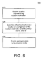
- FIG. 6 is an illustration of an exemplary algorithm according to a further embodiment of the present subject matter.
- a method 600 is provided for sending assistance data to a wireless device.
- a location request may be received for the wireless device, the location request providing location information for the wireless device.
- Exemplary location information may be, but is not limited to, the identification of an approximate cell.
- a reference location may be determined for the wireless device as a function of a comparison of the location information and a region determined as a function of at least one of an MCC, MNC, and an Area-ID.
- assistance data may be provided to the wireless device as a function of the determined reference location.
- the step of determining a reference location may include mining a database for an area corresponding to the finest possible granularity of MCC, MNC, Area-ID, or combinations thereof, the area used as the determined reference location.
- FIGS. 1-6 As shown by the various configurations and embodiments illustrated in FIGS. 1-6 , a system and method for determining a reference location for a mobile device using cell table data mining have been described.
Abstract
Description
Claims (18)
Priority Applications (2)
| Application Number | Priority Date | Filing Date | Title |
|---|---|---|---|
| US12/437,969 US8467805B2 (en) | 2009-05-08 | 2009-05-08 | System and method for determining a reference location using cell table data mining |
| PCT/US2010/027421 WO2010129094A1 (en) | 2009-05-08 | 2010-03-16 | System and method for determining a reference location using cell table data mining |
Applications Claiming Priority (1)
| Application Number | Priority Date | Filing Date | Title |
|---|---|---|---|
| US12/437,969 US8467805B2 (en) | 2009-05-08 | 2009-05-08 | System and method for determining a reference location using cell table data mining |
Publications (2)
| Publication Number | Publication Date |
|---|---|
| US20100285813A1 US20100285813A1 (en) | 2010-11-11 |
| US8467805B2 true US8467805B2 (en) | 2013-06-18 |
Family
ID=42198876
Family Applications (1)
| Application Number | Title | Priority Date | Filing Date |
|---|---|---|---|
| US12/437,969 Active 2031-04-09 US8467805B2 (en) | 2009-05-08 | 2009-05-08 | System and method for determining a reference location using cell table data mining |
Country Status (2)
| Country | Link |
|---|---|
| US (1) | US8467805B2 (en) |
| WO (1) | WO2010129094A1 (en) |
Cited By (3)
| Publication number | Priority date | Publication date | Assignee | Title |
|---|---|---|---|---|
| US8954267B2 (en) * | 2013-02-21 | 2015-02-10 | Qualcomm Incorporated | Mobile device positioning |
| US9185675B2 (en) | 2013-11-18 | 2015-11-10 | Qualcomm Incorporated | Method and apparatus for classifying a mobile device location |
| US10317236B2 (en) * | 2016-08-29 | 2019-06-11 | International Business Machines Corporation | Dynamic GPS location update |
Families Citing this family (10)
| Publication number | Priority date | Publication date | Assignee | Title |
|---|---|---|---|---|
| US8259010B2 (en) * | 2009-10-14 | 2012-09-04 | Qualcomm Incorporated | Qualifying coarse position injection in position determination systems |
| US8554249B2 (en) * | 2009-12-08 | 2013-10-08 | Microsoft Corporation | Location service for wireless devices |
| US8504059B2 (en) * | 2010-01-15 | 2013-08-06 | Apple Inc. | Location filtering using mobile country code |
| US8433334B2 (en) | 2010-01-15 | 2013-04-30 | Apple Inc. | Managing a location database for network-based positioning system |
| US8620344B2 (en) | 2010-04-07 | 2013-12-31 | Apple Inc. | Location-based application program management |
| US8625490B2 (en) | 2011-01-07 | 2014-01-07 | Apple Inc. | Multiple granularity location determination |
| US8229473B1 (en) * | 2011-06-02 | 2012-07-24 | Nokia Siemens Networks Oy | Geo-fence |
| US9301114B2 (en) | 2012-02-22 | 2016-03-29 | Nokia Technologies Oy | Method and apparatus for determining significant places |
| WO2017188894A1 (en) * | 2016-04-29 | 2017-11-02 | Certis Cisco Security Pte. Ltd. | A geolocating system for a mobile device |
| EP3621255A1 (en) * | 2018-09-06 | 2020-03-11 | FRAUNHOFER-GESELLSCHAFT zur Förderung der angewandten Forschung e.V. | Gateway, user terminal, methods for operating the same and wireless communication network |
Citations (64)
| Publication number | Priority date | Publication date | Assignee | Title |
|---|---|---|---|---|
| US4728959A (en) | 1986-08-08 | 1988-03-01 | Ventana Sciences Inc. | Direction finding localization system |
| US5327144A (en) | 1993-05-07 | 1994-07-05 | Associated Rt, Inc. | Cellular telephone location system |
| US5959580A (en) | 1994-11-03 | 1999-09-28 | Ksi Inc. | Communications localization system |
| US6047192A (en) | 1996-05-13 | 2000-04-04 | Ksi Inc. | Robust, efficient, localization system |
| US6091362A (en) | 1999-01-08 | 2000-07-18 | Trueposition, Inc. | Bandwidth synthesis for wireless location system |
| US6097709A (en) | 1996-12-10 | 2000-08-01 | Nec Corporation | TDMA cellular communication system using a receiver station for detecting a timing difference between adjacent base stations |
| US6101178A (en) | 1997-07-10 | 2000-08-08 | Ksi Inc. | Pseudolite-augmented GPS for locating wireless telephones |
| US6108558A (en) | 1998-04-21 | 2000-08-22 | Motorola, Inc. | Method for calculating a location of a remote Unit utilizing observed time difference (OTD) and real time difference (RTD) measurements. |
| US6108555A (en) | 1996-05-17 | 2000-08-22 | Ksi, Inc. | Enchanced time difference localization system |
| US6115605A (en) | 1997-08-29 | 2000-09-05 | Ppm, Inc. | Communication system and device using dynamic receiver addressing |
| US6269246B1 (en) | 1998-09-22 | 2001-07-31 | Ppm, Inc. | Location determination using RF fingerprinting |
| US6334059B1 (en) | 1999-01-08 | 2001-12-25 | Trueposition, Inc. | Modified transmission method for improving accuracy for e-911 calls |
| US6366241B2 (en) | 2000-06-26 | 2002-04-02 | Trueposition, Inc. | Enhanced determination of position-dependent signal characteristics of a wireless transmitter |
| US6388618B1 (en) | 1999-01-08 | 2002-05-14 | Trueposition, Inc. | Signal collection system for a wireless location system |
| US6393294B1 (en) | 1998-09-22 | 2002-05-21 | Polaris Wireless, Inc. | Location determination using RF fingerprinting |
| US6449486B1 (en) | 1998-05-27 | 2002-09-10 | Polaris Wireless, Inc. | Multiple location estimates in a cellular communication system |
| US6463290B1 (en) | 1999-01-08 | 2002-10-08 | Trueposition, Inc. | Mobile-assisted network based techniques for improving accuracy of wireless location system |
| US6646604B2 (en) | 1999-01-08 | 2003-11-11 | Trueposition, Inc. | Automatic synchronous tuning of narrowband receivers of a wireless location system for voice/traffic channel tracking |
| US6765531B2 (en) | 1999-01-08 | 2004-07-20 | Trueposition, Inc. | System and method for interference cancellation in a location calculation, for use in a wireless location system |
| US6782264B2 (en) | 1999-01-08 | 2004-08-24 | Trueposition, Inc. | Monitoring of call information in a wireless location system |
| US20040203539A1 (en) | 2002-12-11 | 2004-10-14 | Benes Stanley J. | Method and mobile station for autonomously determining an angle of arrival (AOA) estimation |
| US6873290B2 (en) | 1999-01-08 | 2005-03-29 | Trueposition, Inc. | Multiple pass location processor |
| US6876859B2 (en) | 2001-07-18 | 2005-04-05 | Trueposition, Inc. | Method for estimating TDOA and FDOA in a wireless location system |
| US20050091689A1 (en) * | 2003-10-23 | 2005-04-28 | Samsung Electronics Co., Ltd. | Apparatus and method for controlling broadcast channel using position information of mobile communication terminal |
| US6944465B2 (en) | 1998-09-22 | 2005-09-13 | Polaris Wireless, Inc. | Estimating the location of a mobile unit based on the elimination of improbable locations |
| US20060003775A1 (en) | 1999-01-08 | 2006-01-05 | Bull Jeffrey F | Advanced triggers for location-based service applications in a wireless location system |
| US6996392B2 (en) | 2002-09-03 | 2006-02-07 | Trueposition, Inc. | E911 overlay solution for GSM, for use in a wireless location system |
| WO2006102508A1 (en) | 2005-03-22 | 2006-09-28 | Qualcomm Incorporated | Methods and systems for deriving seed position of a subscriber station in support of unassisted gps-type position determination in a wireless communication system |
| US7116987B2 (en) | 2003-07-19 | 2006-10-03 | Polaris Wireless, Inc. | Location estimation of wireless terminals through pattern matching of deduced and empirical signal-strength measurements |
| US20070096981A1 (en) | 2005-10-28 | 2007-05-03 | Charles Abraham | Method and apparatus for providing a global secure user plane location (SUPL) service |
| US20070111746A1 (en) | 2005-11-16 | 2007-05-17 | Anderson Robert J | Transmit-power control for wireless mobile services |
| US7233799B2 (en) | 2003-02-24 | 2007-06-19 | Polaris Wireless, Inc. | Location estimation of wireless terminals based on combinations of signal strength measurements and geometry-of-arrival measurements |
| US20070155401A1 (en) | 2005-12-30 | 2007-07-05 | Trueposition Inc. | User plane uplink time difference of arrival (u-tdoa) |
| US20070155489A1 (en) | 2005-12-30 | 2007-07-05 | Frederic Beckley | Device and network enabled geo-fencing for area sensitive gaming enablement |
| US7250907B2 (en) | 2003-06-30 | 2007-07-31 | Microsoft Corporation | System and methods for determining the location dynamics of a portable computing device |
| US7257414B2 (en) | 1998-09-22 | 2007-08-14 | Polaris Wireless, Inc. | Estimating the Location of a Wireless Terminal Based on Non-Uniform Probabilities of Movement |
| US20080132247A1 (en) | 2006-12-01 | 2008-06-05 | Trueposition, Inc. | System for automatically determining cell transmitter parameters to facilitate the location of wireless devices |
| US20080132244A1 (en) | 2006-12-01 | 2008-06-05 | Trueposition, Inc. | Subscriptionless location of wireless devices |
| US20080137524A1 (en) | 2006-12-12 | 2008-06-12 | Trueposition, Inc. | Location of Wideband OFDM Transmitters With Limited Receiver Bandwidth |
| US20080158059A1 (en) | 2006-12-27 | 2008-07-03 | Trueposition, Inc. | Portable, iterative geolocation of RF emitters |
| US20080160952A1 (en) | 2006-12-28 | 2008-07-03 | Trueposition, Inc. | Emergency wireless location system including a location determining receiver |
| US20080160953A1 (en) | 2006-12-28 | 2008-07-03 | Trueposition, Inc. | Emergency wireless location system including a wireless transceiver |
| US7427952B2 (en) | 2005-04-08 | 2008-09-23 | Trueposition, Inc. | Augmentation of commercial wireless location system (WLS) with moving and/or airborne sensors for enhanced location accuracy and use of real-time overhead imagery for identification of wireless device locations |
| US7433652B2 (en) | 2005-03-07 | 2008-10-07 | Polaris Wireless, Inc. | Electro-magnetic propagation modeling |
| US7433695B2 (en) | 2002-11-18 | 2008-10-07 | Polaris Wireless, Inc. | Computationally-efficient estimation of the location of a wireless terminal based on pattern matching |
| US20080248811A1 (en) | 2003-12-30 | 2008-10-09 | Trueposition, Inc. | TDOA/GPS Hybrid Wireless Location System |
| US20080261614A1 (en) | 2007-04-18 | 2008-10-23 | Mia Rashidus S | Sparsed U-TDOA Wireless Location Networks |
| US20080261611A1 (en) | 2007-04-18 | 2008-10-23 | Mia Rashidus S | Sparsed U-TDOA Wireless Location Networks |
| US20080261613A1 (en) | 2007-04-18 | 2008-10-23 | Anderson Robert J | Sparsed U-TDOA Wireless Location Networks |
| US20080261612A1 (en) | 2007-04-18 | 2008-10-23 | Mia Rashidus S | Sparsed U-TDOA Wireless Location Networks |
| US7460505B2 (en) | 2003-02-04 | 2008-12-02 | Polaris Wireless, Inc. | Location estimation of wireless terminals through pattern matching of signal-strength differentials |
| US20080318594A1 (en) | 2005-12-20 | 2008-12-25 | Alcatel Lucent | Pre-Location Method and System For Assisting Satellite Radio Navigation Systems |
| US20090005061A1 (en) | 2005-12-30 | 2009-01-01 | Trueposition, Inc. | Location quality of service indicator |
| US7593738B2 (en) | 2005-12-29 | 2009-09-22 | Trueposition, Inc. | GPS synchronization for wireless communications stations |
| US20100093376A1 (en) * | 2008-10-14 | 2010-04-15 | Del Castillo Manuel | Method and system for area code rough initial position for gnss assistance data in a communication network |
| US7734298B2 (en) | 1998-09-22 | 2010-06-08 | Polaris Wireless, Inc. | Estimating the location of a wireless terminal based on signal path impairment |
| US7753278B2 (en) | 2006-05-22 | 2010-07-13 | Polaris Wireless, Inc. | Estimating the location of a wireless terminal based on non-uniform locations |
| US7796966B2 (en) | 2005-03-15 | 2010-09-14 | Polaris Wireless, Inc. | Estimating the location of a wireless terminal based on calibrated signal-strength measurements |
| US7899467B2 (en) | 1998-09-22 | 2011-03-01 | Polaris Wireless, Inc. | Estimating the location of a wireless terminal based on the traits of the multipath components of a signal |
| US20110171969A1 (en) * | 2008-04-16 | 2011-07-14 | Nokia Corporation | Area event support indication |
| US8013785B2 (en) | 2009-12-31 | 2011-09-06 | Ntt Docomo, Inc. | Positioning system and positioning method |
| US8106817B2 (en) | 2009-12-31 | 2012-01-31 | Polaris Wireless, Inc. | Positioning system and positioning method |
| US8106818B2 (en) | 2009-12-31 | 2012-01-31 | Polaris Wireless, Inc. | Positioning system and positioning method |
| US8155394B2 (en) | 2010-07-13 | 2012-04-10 | Polaris Wireless, Inc. | Wireless location and facial/speaker recognition system |
Family Cites Families (5)
| Publication number | Priority date | Publication date | Assignee | Title |
|---|---|---|---|---|
| US5068855A (en) * | 1988-07-18 | 1991-11-26 | Canon Kabushiki Kaisha | Error correcting method and apparatus |
| US5106818A (en) * | 1989-04-27 | 1992-04-21 | Mitsubishi Paper Mills Limited | Receiving sheet for heat transfer recording |
| US6262246B1 (en) * | 1998-09-25 | 2001-07-17 | Synaptic Pharmaceutical Corporation | DNA encoding mammalian neuropeptides FF (NPFF) receptors and uses thereof |
| US7166987B2 (en) * | 2003-10-10 | 2007-01-23 | R. F. Tech Co., Ltd | Portable charger for mobile phone |
| EP2979950B1 (en) | 2014-07-29 | 2020-09-09 | LEITNER S.p.A. | Trolley for cable transportation system transportation units and depot for transportation units comprising such a trolley |
-
2009
- 2009-05-08 US US12/437,969 patent/US8467805B2/en active Active
-
2010
- 2010-03-16 WO PCT/US2010/027421 patent/WO2010129094A1/en active Application Filing
Patent Citations (105)
| Publication number | Priority date | Publication date | Assignee | Title |
|---|---|---|---|---|
| US4728959A (en) | 1986-08-08 | 1988-03-01 | Ventana Sciences Inc. | Direction finding localization system |
| US5327144A (en) | 1993-05-07 | 1994-07-05 | Associated Rt, Inc. | Cellular telephone location system |
| US5608410A (en) | 1993-05-07 | 1997-03-04 | Associated Rt, Inc. | System for locating a source of bursty transmissions cross reference to related applications |
| US6288675B1 (en) | 1994-11-03 | 2001-09-11 | Ksi, Inc. | Single station communications localization system |
| US6127975A (en) | 1994-11-03 | 2000-10-03 | Ksi, Incorporated | Single station communications localization system |
| US5959580A (en) | 1994-11-03 | 1999-09-28 | Ksi Inc. | Communications localization system |
| US6288676B1 (en) | 1994-11-03 | 2001-09-11 | Ksi, Inc. | Apparatus and method for single station communications localization |
| US20080161015A1 (en) | 1996-05-13 | 2008-07-03 | Trueposition, Inc. | Robust, Efficient, Localization System |
| US6546256B1 (en) | 1996-05-13 | 2003-04-08 | Ksi Inc. | Robust, efficient, location-related measurement |
| US6047192A (en) | 1996-05-13 | 2000-04-04 | Ksi Inc. | Robust, efficient, localization system |
| US7340259B2 (en) | 1996-05-13 | 2008-03-04 | Ksi Inc. | Robust, efficient, localization system |
| US6108555A (en) | 1996-05-17 | 2000-08-22 | Ksi, Inc. | Enchanced time difference localization system |
| US6119013A (en) | 1996-05-17 | 2000-09-12 | Ksi, Inc. | Enhanced time-difference localization system |
| US6097709A (en) | 1996-12-10 | 2000-08-01 | Nec Corporation | TDMA cellular communication system using a receiver station for detecting a timing difference between adjacent base stations |
| US6771625B1 (en) | 1997-07-10 | 2004-08-03 | Ksi, Inc. | Pseudolite-augmented GPS for locating wireless telephones |
| US6101178A (en) | 1997-07-10 | 2000-08-08 | Ksi Inc. | Pseudolite-augmented GPS for locating wireless telephones |
| US6115605A (en) | 1997-08-29 | 2000-09-05 | Ppm, Inc. | Communication system and device using dynamic receiver addressing |
| US6591112B1 (en) | 1997-08-29 | 2003-07-08 | Ppm, Inc. | Communication system and device using dynamic receiver addressing |
| US6108558A (en) | 1998-04-21 | 2000-08-22 | Motorola, Inc. | Method for calculating a location of a remote Unit utilizing observed time difference (OTD) and real time difference (RTD) measurements. |
| US6449486B1 (en) | 1998-05-27 | 2002-09-10 | Polaris Wireless, Inc. | Multiple location estimates in a cellular communication system |
| US6269246B1 (en) | 1998-09-22 | 2001-07-31 | Ppm, Inc. | Location determination using RF fingerprinting |
| US7257414B2 (en) | 1998-09-22 | 2007-08-14 | Polaris Wireless, Inc. | Estimating the Location of a Wireless Terminal Based on Non-Uniform Probabilities of Movement |
| US7899467B2 (en) | 1998-09-22 | 2011-03-01 | Polaris Wireless, Inc. | Estimating the location of a wireless terminal based on the traits of the multipath components of a signal |
| US7167714B2 (en) | 1998-09-22 | 2007-01-23 | Polaris Wireless, Inc. | Location determination using RF fingerprints |
| US8068855B2 (en) | 1998-09-22 | 2011-11-29 | Polaris Wireless, Inc. | Location determination using RF fingerprinting |
| US6944465B2 (en) | 1998-09-22 | 2005-09-13 | Polaris Wireless, Inc. | Estimating the location of a mobile unit based on the elimination of improbable locations |
| US6782265B2 (en) | 1998-09-22 | 2004-08-24 | Polaris Wireless, Inc. | Location determination using RF fingerprinting |
| US7383051B2 (en) | 1998-09-22 | 2008-06-03 | Polaris Wireless, Inc. | Estimating the location of a mobile unit based on the elimination of improbable locations |
| US7725111B2 (en) | 1998-09-22 | 2010-05-25 | Polaris Wireless, Inc. | Location determination using RF fingerprinting |
| US6393294B1 (en) | 1998-09-22 | 2002-05-21 | Polaris Wireless, Inc. | Location determination using RF fingerprinting |
| US7734298B2 (en) | 1998-09-22 | 2010-06-08 | Polaris Wireless, Inc. | Estimating the location of a wireless terminal based on signal path impairment |
| US20060003775A1 (en) | 1999-01-08 | 2006-01-05 | Bull Jeffrey F | Advanced triggers for location-based service applications in a wireless location system |
| US6091362A (en) | 1999-01-08 | 2000-07-18 | Trueposition, Inc. | Bandwidth synthesis for wireless location system |
| US6483460B2 (en) | 1999-01-08 | 2002-11-19 | Trueposition, Inc. | Baseline selection method for use in a wireless location system |
| US20020172223A1 (en) | 1999-01-08 | 2002-11-21 | Stilp Louis A. | Calibration for wireless location system |
| US6492944B1 (en) | 1999-01-08 | 2002-12-10 | Trueposition, Inc. | Internal calibration method for receiver system of a wireless location system |
| US6519465B2 (en) | 1999-01-08 | 2003-02-11 | Trueposition, Inc. | Modified transmission method for improving accuracy for E-911 calls |
| US20030064734A1 (en) | 1999-01-08 | 2003-04-03 | Trueposition, Inc. | Modified transmission method for improving accuracy for E-911 calls |
| US6400320B1 (en) | 1999-01-08 | 2002-06-04 | Trueposition, Inc. | Antenna selection method for a wireless location system |
| US6563460B2 (en) | 1999-01-08 | 2003-05-13 | Trueposition, Inc. | Collision recovery in a wireless location system |
| US6388618B1 (en) | 1999-01-08 | 2002-05-14 | Trueposition, Inc. | Signal collection system for a wireless location system |
| US6603428B2 (en) | 1999-01-08 | 2003-08-05 | Trueposition, Inc. | Multiple pass location processing |
| US6646604B2 (en) | 1999-01-08 | 2003-11-11 | Trueposition, Inc. | Automatic synchronous tuning of narrowband receivers of a wireless location system for voice/traffic channel tracking |
| US6661379B2 (en) | 1999-01-08 | 2003-12-09 | Trueposition, Inc. | Antenna selection method for a wireless location system |
| US6765531B2 (en) | 1999-01-08 | 2004-07-20 | Trueposition, Inc. | System and method for interference cancellation in a location calculation, for use in a wireless location system |
| US7271765B2 (en) | 1999-01-08 | 2007-09-18 | Trueposition, Inc. | Applications processor including a database system, for use in a wireless location system |
| US6351235B1 (en) | 1999-01-08 | 2002-02-26 | Trueposition, Inc. | Method and system for synchronizing receiver systems of a wireless location system |
| US6782264B2 (en) | 1999-01-08 | 2004-08-24 | Trueposition, Inc. | Monitoring of call information in a wireless location system |
| US6285321B1 (en) | 1999-01-08 | 2001-09-04 | Trueposition, Inc. | Station based processing method for a wireless location system |
| US6873290B2 (en) | 1999-01-08 | 2005-03-29 | Trueposition, Inc. | Multiple pass location processor |
| US6463290B1 (en) | 1999-01-08 | 2002-10-08 | Trueposition, Inc. | Mobile-assisted network based techniques for improving accuracy of wireless location system |
| US6097336A (en) | 1999-01-08 | 2000-08-01 | Trueposition, Inc. | Method for improving the accuracy of a wireless location system |
| US6334059B1 (en) | 1999-01-08 | 2001-12-25 | Trueposition, Inc. | Modified transmission method for improving accuracy for e-911 calls |
| US6317081B1 (en) | 1999-01-08 | 2001-11-13 | Trueposition, Inc. | Internal calibration method for receiver system of a wireless location system |
| US6115599A (en) | 1999-01-08 | 2000-09-05 | Trueposition, Inc. | Directed retry method for use in a wireless location system |
| US20060030333A1 (en) | 1999-01-08 | 2006-02-09 | Ward Matthew L | Geo-fencing in a wireless location system |
| US7023383B2 (en) | 1999-01-08 | 2006-04-04 | Trueposition, Inc. | Multiple pass location processor |
| US6172644B1 (en) | 1999-01-08 | 2001-01-09 | Trueposition, Inc. | Emergency location method for a wireless location system |
| US6184829B1 (en) | 1999-01-08 | 2001-02-06 | Trueposition, Inc. | Calibration for wireless location system |
| US6317604B1 (en) | 1999-01-08 | 2001-11-13 | Trueposition, Inc. | Centralized database system for a wireless location system |
| US7167713B2 (en) | 1999-01-08 | 2007-01-23 | Trueposition, Inc. | Monitoring of call information in a wireless location system |
| US6266013B1 (en) | 1999-01-08 | 2001-07-24 | Trueposition, Inc. | Architecture for a signal collection system of a wireless location system |
| US6281834B1 (en) | 1999-01-08 | 2001-08-28 | Trueposition, Inc. | Calibration for wireless location system |
| US6366241B2 (en) | 2000-06-26 | 2002-04-02 | Trueposition, Inc. | Enhanced determination of position-dependent signal characteristics of a wireless transmitter |
| US6876859B2 (en) | 2001-07-18 | 2005-04-05 | Trueposition, Inc. | Method for estimating TDOA and FDOA in a wireless location system |
| US6996392B2 (en) | 2002-09-03 | 2006-02-07 | Trueposition, Inc. | E911 overlay solution for GSM, for use in a wireless location system |
| US7848762B2 (en) | 2002-11-18 | 2010-12-07 | Polaris Wireless, Inc. | Computationally-efficient estimation of the location of a wireless terminal based on pattern matching |
| US7433695B2 (en) | 2002-11-18 | 2008-10-07 | Polaris Wireless, Inc. | Computationally-efficient estimation of the location of a wireless terminal based on pattern matching |
| US20040203539A1 (en) | 2002-12-11 | 2004-10-14 | Benes Stanley J. | Method and mobile station for autonomously determining an angle of arrival (AOA) estimation |
| US7460505B2 (en) | 2003-02-04 | 2008-12-02 | Polaris Wireless, Inc. | Location estimation of wireless terminals through pattern matching of signal-strength differentials |
| US7233799B2 (en) | 2003-02-24 | 2007-06-19 | Polaris Wireless, Inc. | Location estimation of wireless terminals based on combinations of signal strength measurements and geometry-of-arrival measurements |
| US7250907B2 (en) | 2003-06-30 | 2007-07-31 | Microsoft Corporation | System and methods for determining the location dynamics of a portable computing device |
| US7116987B2 (en) | 2003-07-19 | 2006-10-03 | Polaris Wireless, Inc. | Location estimation of wireless terminals through pattern matching of deduced and empirical signal-strength measurements |
| US20050091689A1 (en) * | 2003-10-23 | 2005-04-28 | Samsung Electronics Co., Ltd. | Apparatus and method for controlling broadcast channel using position information of mobile communication terminal |
| US20080248811A1 (en) | 2003-12-30 | 2008-10-09 | Trueposition, Inc. | TDOA/GPS Hybrid Wireless Location System |
| US7440762B2 (en) | 2003-12-30 | 2008-10-21 | Trueposition, Inc. | TDOA/GPS hybrid wireless location system |
| US7433652B2 (en) | 2005-03-07 | 2008-10-07 | Polaris Wireless, Inc. | Electro-magnetic propagation modeling |
| US7796966B2 (en) | 2005-03-15 | 2010-09-14 | Polaris Wireless, Inc. | Estimating the location of a wireless terminal based on calibrated signal-strength measurements |
| US8068802B2 (en) | 2005-03-15 | 2011-11-29 | Polaris Wireless, Inc. | Estimating the location of a wireless terminal based on calibrated signal-strength measurements |
| WO2006102508A1 (en) | 2005-03-22 | 2006-09-28 | Qualcomm Incorporated | Methods and systems for deriving seed position of a subscriber station in support of unassisted gps-type position determination in a wireless communication system |
| US7427952B2 (en) | 2005-04-08 | 2008-09-23 | Trueposition, Inc. | Augmentation of commercial wireless location system (WLS) with moving and/or airborne sensors for enhanced location accuracy and use of real-time overhead imagery for identification of wireless device locations |
| US20070096981A1 (en) | 2005-10-28 | 2007-05-03 | Charles Abraham | Method and apparatus for providing a global secure user plane location (SUPL) service |
| US20070111746A1 (en) | 2005-11-16 | 2007-05-17 | Anderson Robert J | Transmit-power control for wireless mobile services |
| US20080318594A1 (en) | 2005-12-20 | 2008-12-25 | Alcatel Lucent | Pre-Location Method and System For Assisting Satellite Radio Navigation Systems |
| US7593738B2 (en) | 2005-12-29 | 2009-09-22 | Trueposition, Inc. | GPS synchronization for wireless communications stations |
| US20070155489A1 (en) | 2005-12-30 | 2007-07-05 | Frederic Beckley | Device and network enabled geo-fencing for area sensitive gaming enablement |
| US20090005061A1 (en) | 2005-12-30 | 2009-01-01 | Trueposition, Inc. | Location quality of service indicator |
| US20070155401A1 (en) | 2005-12-30 | 2007-07-05 | Trueposition Inc. | User plane uplink time difference of arrival (u-tdoa) |
| US7753278B2 (en) | 2006-05-22 | 2010-07-13 | Polaris Wireless, Inc. | Estimating the location of a wireless terminal based on non-uniform locations |
| US20080132247A1 (en) | 2006-12-01 | 2008-06-05 | Trueposition, Inc. | System for automatically determining cell transmitter parameters to facilitate the location of wireless devices |
| US20080132244A1 (en) | 2006-12-01 | 2008-06-05 | Trueposition, Inc. | Subscriptionless location of wireless devices |
| US20080137524A1 (en) | 2006-12-12 | 2008-06-12 | Trueposition, Inc. | Location of Wideband OFDM Transmitters With Limited Receiver Bandwidth |
| US20080158059A1 (en) | 2006-12-27 | 2008-07-03 | Trueposition, Inc. | Portable, iterative geolocation of RF emitters |
| US20080160953A1 (en) | 2006-12-28 | 2008-07-03 | Trueposition, Inc. | Emergency wireless location system including a wireless transceiver |
| US20080160952A1 (en) | 2006-12-28 | 2008-07-03 | Trueposition, Inc. | Emergency wireless location system including a location determining receiver |
| US20080261612A1 (en) | 2007-04-18 | 2008-10-23 | Mia Rashidus S | Sparsed U-TDOA Wireless Location Networks |
| US20080261613A1 (en) | 2007-04-18 | 2008-10-23 | Anderson Robert J | Sparsed U-TDOA Wireless Location Networks |
| US20080261611A1 (en) | 2007-04-18 | 2008-10-23 | Mia Rashidus S | Sparsed U-TDOA Wireless Location Networks |
| US20080261614A1 (en) | 2007-04-18 | 2008-10-23 | Mia Rashidus S | Sparsed U-TDOA Wireless Location Networks |
| US20110171969A1 (en) * | 2008-04-16 | 2011-07-14 | Nokia Corporation | Area event support indication |
| US20100093376A1 (en) * | 2008-10-14 | 2010-04-15 | Del Castillo Manuel | Method and system for area code rough initial position for gnss assistance data in a communication network |
| US8013785B2 (en) | 2009-12-31 | 2011-09-06 | Ntt Docomo, Inc. | Positioning system and positioning method |
| US8106817B2 (en) | 2009-12-31 | 2012-01-31 | Polaris Wireless, Inc. | Positioning system and positioning method |
| US8106818B2 (en) | 2009-12-31 | 2012-01-31 | Polaris Wireless, Inc. | Positioning system and positioning method |
| US8155394B2 (en) | 2010-07-13 | 2012-04-10 | Polaris Wireless, Inc. | Wireless location and facial/speaker recognition system |
Non-Patent Citations (3)
| Title |
|---|
| Rick Roberts, "Project: IEEE P802.15 Working Group for Wireless Personal Area Networks (WPANS)," Harris Corporation, Melbourne Florida, Oct. 4, 2004, pp. 1-11. |
| Stephanie Bell, A Beginners Guide to Uncertainty of Measurement, The National Physics Laboratory of the United Kingdom of Great Britain and Northern Ireland, Teddington, Middlesex, UK, 2001, pp. 1-41. |
| Tolga Goze; "Secure User-Plane Location (SUPL) Architecture for Assisted GPS (A-GPS)" IEEE; Department of Electrical & Computer Eng.; Koc University, Istanbul, Turkey; 2008; pp. 229-234. |
Cited By (4)
| Publication number | Priority date | Publication date | Assignee | Title |
|---|---|---|---|---|
| US8954267B2 (en) * | 2013-02-21 | 2015-02-10 | Qualcomm Incorporated | Mobile device positioning |
| US9185675B2 (en) | 2013-11-18 | 2015-11-10 | Qualcomm Incorporated | Method and apparatus for classifying a mobile device location |
| US10317236B2 (en) * | 2016-08-29 | 2019-06-11 | International Business Machines Corporation | Dynamic GPS location update |
| US10591308B2 (en) | 2016-08-29 | 2020-03-17 | International Business Machines Corporation | Dynamic GPS location update |
Also Published As
| Publication number | Publication date |
|---|---|
| WO2010129094A1 (en) | 2010-11-11 |
| US20100285813A1 (en) | 2010-11-11 |
Similar Documents
| Publication | Publication Date | Title |
|---|---|---|
| US7916071B2 (en) | System and method for determining a reference location of a mobile device | |
| US8467805B2 (en) | System and method for determining a reference location using cell table data mining | |
| US8299961B2 (en) | Method and system for selecting optimal satellites in view | |
| US7920091B2 (en) | System and method for A-GPS positioning of a mobile device | |
| US7928903B2 (en) | Method and system for selecting optimal satellites for A-GPS location of handsets in wireless networks | |
| US20100127923A1 (en) | System and method for determining falsified satellite measurements | |
| US8217832B2 (en) | Enhancing location accuracy using multiple satellite measurements based on environment | |
| US8378888B2 (en) | System and method for determining the location of a mobile device | |
| US20100127920A1 (en) | System and method for determining falsified geographic location of a mobile device | |
| WO2010080675A2 (en) | Method and system for selecting optimal satellites for a-gps location of handsets in wireless networks | |
| US20160033650A1 (en) | Method and system for selecting optimal satellites for a-gps location of handsets in wireless networks | |
| US20100149031A1 (en) | System and method for determining forged radio frequency measurements | |
| US7999730B2 (en) | System and method for providing GNSS assistant data without dedicated receivers |
Legal Events
| Date | Code | Title | Description |
|---|---|---|---|
| AS | Assignment |
Owner name: ANDREW LLC, NORTH CAROLINA Free format text: ASSIGNMENT OF ASSIGNORS INTEREST;ASSIGNOR:HARPER, NEIL;REEL/FRAME:022658/0671 Effective date: 20090507 |
|
| AS | Assignment |
Owner name: BANK OF AMERICA, N.A., AS ADMINISTRATIVE AGENT, CA Free format text: SECURITY AGREEMENT;ASSIGNORS:COMMSCOPE OF NORTH CAROLINA;ANDREW LLC;REEL/FRAME:023021/0481 Effective date: 20090728 |
|
| AS | Assignment |
Owner name: COMMSCOPE, INC. OF NORTH CAROLINA, NORTH CAROLINA Free format text: PATENT RELEASE;ASSIGNOR:BANK OF AMERICA, N.A., AS ADMINISTRATIVE AGENT;REEL/FRAME:026039/0005 Effective date: 20110114 Owner name: ANDREW LLC (F/K/A ANDREW CORPORATION), NORTH CAROL Free format text: PATENT RELEASE;ASSIGNOR:BANK OF AMERICA, N.A., AS ADMINISTRATIVE AGENT;REEL/FRAME:026039/0005 Effective date: 20110114 Owner name: ALLEN TELECOM LLC, NORTH CAROLINA Free format text: PATENT RELEASE;ASSIGNOR:BANK OF AMERICA, N.A., AS ADMINISTRATIVE AGENT;REEL/FRAME:026039/0005 Effective date: 20110114 |
|
| AS | Assignment |
Owner name: JPMORGAN CHASE BANK, N.A., AS COLLATERAL AGENT, NE Free format text: SECURITY AGREEMENT;ASSIGNORS:ALLEN TELECOM LLC, A DELAWARE LLC;ANDREW LLC, A DELAWARE LLC;COMMSCOPE, INC. OF NORTH CAROLINA, A NORTH CAROLINA CORPORATION;REEL/FRAME:026276/0363 Effective date: 20110114 |
|
| AS | Assignment |
Owner name: JPMORGAN CHASE BANK, N.A., AS COLLATERAL AGENT, NE Free format text: SECURITY AGREEMENT;ASSIGNORS:ALLEN TELECOM LLC, A DELAWARE LLC;ANDREW LLC, A DELAWARE LLC;COMMSCOPE, INC OF NORTH CAROLINA, A NORTH CAROLINA CORPORATION;REEL/FRAME:026272/0543 Effective date: 20110114 |
|
| STCF | Information on status: patent grant |
Free format text: PATENTED CASE |
|
| AS | Assignment |
Owner name: COMMSCOPE, INC. OF NORTH CAROLINA, NORTH CAROLINA Free format text: PATENT RELEASE;ASSIGNOR:JPMORGAN CHASE BANK, N.A., AS COLLATERAL AGENT;REEL/FRAME:030656/0973 Effective date: 20130618 Owner name: COMMSCOPE, INC. OF NORTH CAROLINA, NORTH CAROLINA Free format text: PATENT RELEASE;ASSIGNOR:JPMORGAN CHASE BANK, N.A., AS COLLATERAL AGENT;REEL/FRAME:030656/0922 Effective date: 20130618 Owner name: ANDREW LLC, NORTH CAROLINA Free format text: PATENT RELEASE;ASSIGNOR:JPMORGAN CHASE BANK, N.A., AS COLLATERAL AGENT;REEL/FRAME:030656/0973 Effective date: 20130618 Owner name: ANDREW LLC, NORTH CAROLINA Free format text: PATENT RELEASE;ASSIGNOR:JPMORGAN CHASE BANK, N.A., AS COLLATERAL AGENT;REEL/FRAME:030656/0922 Effective date: 20130618 |
|
| AS | Assignment |
Owner name: MAPLE ACQUISITION LLC, MARYLAND Free format text: ASSIGNMENT OF ASSIGNORS INTEREST;ASSIGNORS:COMMSCOPE, INC. OF NORTH CAROLINA;ANDREW LLC;REEL/FRAME:030739/0969 Effective date: 20130607 |
|
| AS | Assignment |
Owner name: TELECOMMUNICATION SYSTEMS, INC., MARYLAND Free format text: ASSIGNMENT OF ASSIGNORS INTEREST;ASSIGNOR:MAPLE ACQUISITION LLC;REEL/FRAME:037057/0781 Effective date: 20151106 |
|
| AS | Assignment |
Owner name: CITIBANK N.A., AS ADMINISTRATIVE AGENT, NEW YORK Free format text: SECURITY AGREEMENT;ASSIGNORS:COMTECH EF DATA CORP.;COMTECH XICOM TECHNOLOGY, INC.;COMTECH MOBILE DATACOM CORPORATION;AND OTHERS;REEL/FRAME:037993/0001 Effective date: 20160223 |
|
| FPAY | Fee payment |
Year of fee payment: 4 |
|
| AS | Assignment |
Owner name: ANDREW LLC, NORTH CAROLINA Free format text: RELEASE BY SECURED PARTY;ASSIGNOR:JPMORGAN CHASE BANK, N.A.;REEL/FRAME:048840/0001 Effective date: 20190404 Owner name: COMMSCOPE, INC. OF NORTH CAROLINA, NORTH CAROLINA Free format text: RELEASE BY SECURED PARTY;ASSIGNOR:JPMORGAN CHASE BANK, N.A.;REEL/FRAME:048840/0001 Effective date: 20190404 Owner name: REDWOOD SYSTEMS, INC., NORTH CAROLINA Free format text: RELEASE BY SECURED PARTY;ASSIGNOR:JPMORGAN CHASE BANK, N.A.;REEL/FRAME:048840/0001 Effective date: 20190404 Owner name: COMMSCOPE TECHNOLOGIES LLC, NORTH CAROLINA Free format text: RELEASE BY SECURED PARTY;ASSIGNOR:JPMORGAN CHASE BANK, N.A.;REEL/FRAME:048840/0001 Effective date: 20190404 Owner name: ALLEN TELECOM LLC, ILLINOIS Free format text: RELEASE BY SECURED PARTY;ASSIGNOR:JPMORGAN CHASE BANK, N.A.;REEL/FRAME:048840/0001 Effective date: 20190404 Owner name: REDWOOD SYSTEMS, INC., NORTH CAROLINA Free format text: RELEASE BY SECURED PARTY;ASSIGNOR:JPMORGAN CHASE BANK, N.A.;REEL/FRAME:049260/0001 Effective date: 20190404 Owner name: COMMSCOPE TECHNOLOGIES LLC, NORTH CAROLINA Free format text: RELEASE BY SECURED PARTY;ASSIGNOR:JPMORGAN CHASE BANK, N.A.;REEL/FRAME:049260/0001 Effective date: 20190404 Owner name: ALLEN TELECOM LLC, ILLINOIS Free format text: RELEASE BY SECURED PARTY;ASSIGNOR:JPMORGAN CHASE BANK, N.A.;REEL/FRAME:049260/0001 Effective date: 20190404 Owner name: ANDREW LLC, NORTH CAROLINA Free format text: RELEASE BY SECURED PARTY;ASSIGNOR:JPMORGAN CHASE BANK, N.A.;REEL/FRAME:049260/0001 Effective date: 20190404 Owner name: COMMSCOPE, INC. OF NORTH CAROLINA, NORTH CAROLINA Free format text: RELEASE BY SECURED PARTY;ASSIGNOR:JPMORGAN CHASE BANK, N.A.;REEL/FRAME:049260/0001 Effective date: 20190404 |
|
| MAFP | Maintenance fee payment |
Free format text: PAYMENT OF MAINTENANCE FEE, 8TH YEAR, LARGE ENTITY (ORIGINAL EVENT CODE: M1552); ENTITY STATUS OF PATENT OWNER: LARGE ENTITY Year of fee payment: 8 |