US8626430B2 - System and method of path point reduction - Google Patents
System and method of path point reduction Download PDFInfo
- Publication number
- US8626430B2 US8626430B2 US12/238,703 US23870308A US8626430B2 US 8626430 B2 US8626430 B2 US 8626430B2 US 23870308 A US23870308 A US 23870308A US 8626430 B2 US8626430 B2 US 8626430B2
- Authority
- US
- United States
- Prior art keywords
- waypoints
- path
- distal
- route
- proximal
- Prior art date
- Legal status (The legal status is an assumption and is not a legal conclusion. Google has not performed a legal analysis and makes no representation as to the accuracy of the status listed.)
- Active, expires
Links
Images


Classifications
-
- G—PHYSICS
- G01—MEASURING; TESTING
- G01C—MEASURING DISTANCES, LEVELS OR BEARINGS; SURVEYING; NAVIGATION; GYROSCOPIC INSTRUMENTS; PHOTOGRAMMETRY OR VIDEOGRAMMETRY
- G01C21/00—Navigation; Navigational instruments not provided for in groups G01C1/00 - G01C19/00
- G01C21/26—Navigation; Navigational instruments not provided for in groups G01C1/00 - G01C19/00 specially adapted for navigation in a road network
- G01C21/34—Route searching; Route guidance
- G01C21/3446—Details of route searching algorithms, e.g. Dijkstra, A*, arc-flags, using precalculated routes
-
- H—ELECTRICITY
- H04—ELECTRIC COMMUNICATION TECHNIQUE
- H04W—WIRELESS COMMUNICATION NETWORKS
- H04W28/00—Network traffic management; Network resource management
- H04W28/02—Traffic management, e.g. flow control or congestion control
- H04W28/06—Optimizing the usage of the radio link, e.g. header compression, information sizing, discarding information
Definitions
- the present disclosure relates generally to location based services for wireless communications devices and, in particular, to techniques for reducing the waypoints of a path for display on a wireless communications device.
- Wireless communications devices such as the BlackBerryTM by Research in Motion Limited enable users to download map content from web-based data sources such as BlackBerry MapsTM, Google MapsTM or MapquestTM. Downloaded map content is displayed on a small LCD display screen of the wireless communications device for viewing by the user. The user can pan up and down and side to side as well as zoom in or out. Due to the small display on the device and due to the limited over-the-air (OTA) bandwidth, there is a need to optimize the delivery and handling of the map data.
- OTA over-the-air
- GPS Global Positioning System
- the server When the user requests a route between starting and destination locations (that is, the end-points of the route), the server generates a path represented by a series of waypoints between the two user-defined end-points, as well as a set of directions (for example “driving instructions”) for following the route.
- the directions are associated with “decision points” that are located along the route, for example at each intersection or junction where the user must make a turn or take one of two or more possible roads.
- the “route” refers to a sequence of roads, highways, etc. that the user must follow in order to travel between the starting and destination points.
- the route also provides a context for directions intended to guide the user along the route, and decision points.
- a “path” is an abstract representation of the route, which is intended to be graphically superimposed over a map display of all or part of the route, so as to assist the user in identifying and following the route.
- the path is represented by a set of waypoints distributed along the route. Representation of the path as a set of waypoints enables simple computation and storage of the path, and allows the path to be overlayed onto the map display with proper scaling.
- the set of waypoints defining the path will be downloaded to the wireless communications device as part of the data file containing the route information.
- the path is normally displayed as a series of straight line segments (otherwise known as vectors) extending between successive waypoints. The waypoints themselves will not normally be shown on the display.
- a limitation of the conventional methods is that if the path is very long, the number of waypoints may become too large to send over-the-air in a timely fashion. Therefore, if the path contains more than a maximum number of waypoints which can reasonably be transmitted over-the-air in a timely fashion, some waypoints must be removed to reduce the total number of waypoints.
- a disadvantage of this approach is that reducing the number of waypoints also has the effect of reducing the accuracy with which the path traces the route on a map display.
- FIGS. 1 a - b are maps generated by a well-known mapping service, which illustrate this problem.
- FIG. 1 a shows a portion of a route 2 in which the user is directed to exit “Moreno Valley Freeway” 60 and merge onto “Riverside Freeway” 91 .
- the actual route 2 is shown in dashed line.
- the path 4 shown in solid line, deviates markedly from the route 2 , due to the reduced set of waypoints used to define the path 4 .
- FIG. 1 a shows a portion of a route 2 in which the user is directed to exit “
- FIG. 1 b shows a portion of a route 2 within a city, in which the user is directed from 1 st avenue to the Cabrillo Freeway 163 via a series of access lanes and on-ramps.
- the actual route 2 is shown in dashed line.
- the path 4 shown in solid line, deviates markedly from the route, due to the reduced set of waypoints. In this case, the deviation is so severe that the path display provides little useful guidance to the user, even though the overall error of the path—measured along the entire length of the route—has been minimized.
- FIG. 2 illustrates another example, in which a pair of decision points 19 and 20 are shown along a route in which the user is guided onto “Berliner Ring” via an on-ramp.
- the path fails to follow the on-ramp, and even misses one of the decision points ( 19 , 20 ) altogether, due to the reduced set of waypoints.
- FIGS. 1 a and 1 b are images of a map display showing a path computed using conventional methods
- FIG. 2 is an image of map display showing a portion of a route including a pair of decision points and a path computed using conventional methods
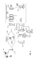
- FIG. 3 is a schematic depiction of a representative network enabling wireless devices to access location-based services, in which the present technique may be employed;
- FIG. 4 is a block diagram depicting principal components of a GPS-enabled wireless communications device usable in the network of FIG. 1 ;
- FIGS. 5 a and 5 b schematically illustrate computation of a reduced waypoint path according to an embodiment of the present technique.
- FIGS. 6 a - c are flow charts showing a representative algorithm for computation of a reduced waypoint path according to an embodiment of the present technique.
- the present technology provides, in general, a method of reducing waypoints representing a path while ensuring that the path accurately follows a route in the vicinity of decision points.
- an aspect of the present technology provides a method of reducing waypoints representing a path defined along a route between a starting point and a destination, the path including one or more decision points.
- the total number of waypoints representing the path is reduced by eliminating one or more waypoints that are distal each decision point of the path, while retaining waypoints that are proximal each decision point.
- Another aspect of the present technology is a computer program product comprising code adapted to perform the steps of the foregoing method when the computer program product is loaded into memory and executed on a processor of a server hosting the wireless communications device.
- a wireless communications device comprising a radiofrequency transceiver for receiving data comprising waypoints representing a path defined along a route between two endpoints, the route including a set of critical points including the endpoints and any decision points of the route intermediate the two endpoints and a processor coupled to memory for eliminating one or waypoints of the path that are distal each critical point, while retaining waypoints that are proximal each critical point.
- Yet another aspect of the present technology is a method of displaying a navigation path on a map displayed on a display of a wireless communications device.
- the method involves steps of sending a request for the navigation path to a server and receiving from the server a reduced point path representing the navigation path for a route between two endpoints the route including a set of critical points including the endpoints and any decision points of the route intermediate the two endpoints, wherein the reduced point path is generated by eliminating one or more waypoints of the path that are distal each critical point while retaining waypoints that are proximal each critical point.
- FIG. 3 schematically illustrates a representative network in which the present technique may be employed.
- one or more wireless communications devices 100 communicate wirelessly with a mobile carrier network 220 via one or more base station towers 210 .
- the wireless communications devices can be wireless handhelds such as the BlackBerryTM from Research in Motion Limited, but could also be other devices with GPS capabilities such as cellular phones, wireless-enabled PDAs, wireless-enabled laptops, etc.
- both private and public location-based services can be accessed via the mobile carrier 220 .
- public LBS can be accessed via the Network Operations Center (NOC) 240 via a firewall 230 .
- NOC 240 includes a relay 242 , a public MDS 244 (e.g. BlackBerry Mobile Data SystemTM) which is connected to one or more LBS Network Servers 246 (each having their own LBS database 248 ).
- the relay 242 is also connected via a secure channel 250 via a firewall 252 to a Corporate Enterprise System (e.g. BES) and a Corporate MDS Server 256 which is, in turn, optionally connected to a corporate LBS Server 260 (and its database 262 ).
- the corporate MDS Server 256 in the example shown in FIG. 1 , also has an Internet connection via another firewall 258 to the LBS Network Server 246 .
- Wireless communications devices 100 issue requests for LBS (including map data) to relay 242 . These requests are passed via the secure channel 250 through firewall 252 to the corporate enterprise server 254 and corporate mobile data system (MDS) server 256 . The LBS request is then passed via firewall 258 to a public location-based service (LBS) server 246 which provides location-based services (LBS) to handle the request.
- LBS public location-based service
- the network may include a plurality of LBS servers where requests are distributed and processed through a load distributing server.
- the LBS data may be stored on this network server 246 or in a database 248 .
- Private corporate data stored on corporate LBS server(s) 260 may be added to, or superimposed on, the public data using corporate enterprise system 254 and corporate MDS server 256 on the secure return path to the wireless device 100 .
- the LBS request from the wireless device 100 may be passed via relay 307 to the public MDS server 244 , which sends the request to the public LBS server 246 providing location-based services in response to the request.
- the location-based services may include mapping and routing services, including the calculation of a route between starting and destination points provided in the request, selection of decision points and associated steering directions to guide the user along the route, and determination of a path along the route, which enables the route to be highlighted on a map display showing all or part of the route.
- the path will normally be represented as a series of waypoints, which can be downloaded to the wireless communications devices 100 to facilitate display.
- This technology can be used in conjunction with turn-by-turn GPS navigation software which not only plots the path to be taken but also shows the real-time position of the device along the path (or elsewhere on the map if the device has diverted off the navigation path).
- FIG. 4 is a block diagram illustrating principal components of a GPS-enabled wireless communications device 100 . It should be expressly understood that this figure is intentionally simplified to show only certain components; the device 100 of course includes other components beyond what are shown in the figures.
- the device 100 includes a microprocessor 102 (or simply a “processor”) which interacts with memory in the form of RAM 104 and Flash Memory 106 , as is well known in the art.
- the device 100 includes an RF transceiver 108 for communicating wirelessly with base stations 210 .
- the device 100 includes a GPS receiver chipset 110 for receiving GPS radio signals transmitted from one or more orbiting GPS satellites.
- the device 100 typically includes a display 112 (e.g.
- Map and path data are received through the RF transceiver 108 . Controlled by the processor 102 , the map and path data are then stored in RAM 104 and displayed on display 112 . In order to reduce demand on processor resources, the processor 102 will render the path as a set of straight line segments (or vectors) extending between successive waypoints. Typically, the waypoints and vectors are not annotated on the map display.
- the public LBS server 246 implements an algorithm for reducing the number of waypoints representing the path.
- this algorithm is designed to preferentially eliminate waypoints that are remote (that is, distal) from each of the critical points of the route.
- critical points should be understood to be a generic reference to the two endpoints and any decision points of the route between the two endpoints.
- the route 2 may be divided into segments, including proximal segments 6 encompassing each critical point (endpoint or decision point) of the route, and distal segments 8 extending between adjacent proximal segments, as may be seen in FIG. 5 a . Waypoints can then be eliminated from each of the distal segments 8 , while preserving the waypoints encompassed by each proximal segment 6 .
- This arrangement enables the total number of waypoints of the path to be reduced, while at the same time preserving waypoints close to each of the critical points of the route, so that the path will accurately follow the actual route in the vicinity of each critical point of the route, as may be seen in FIG. 5 b .
- the path may deviate from the route, and the amount of deviation may tend to increase as the separation between critical points increases, as may also be seen in FIG. 5 b .
- this is considered to be acceptable, because along these portions of the route, the user merely needs to follow a road they are currently on. As a result, the user does not need to rely on the path display for navigation, and errors in the path display will not cause serious problems.
- close to decision points and endpoints, where an accurate display of the path is very useful for navigation the present technique ensures that the path display will properly trace the actual route on the map.
- the route is divided into respective proximal segments 6 associated with each critical point, and distal segments 8 spanning the gaps between adjacent proximal segments.
- the set of waypoints lying within the distal segments 8 can be identified as “distal waypoints”, and processed to reduce the total number of waypoints of the path.
- Various methods may be used to process the distal waypoints, such as, for example: progressively eliminating waypoints starting at the mid-point of each leg of the route, as described above: executing a conventional route generalization algorithm, for example to minimize total path error; or simply deleting all of the distal waypoints. In either case, since processing is limited to the set of “distal waypoints”, the “proximal waypoints” are preserved, and so the path accuracy in the vicinity of each critical point is retained.
- proximal segments 6 may be defined, or, equivalently, the set of proximal waypoints.
- a predetermined number of waypoints for example, 5
- waypoints lying within a predetermined distance for example 1.6 km (1 mile)
- the predetermined number (or distance) used to select the proximal waypoints may be different on each side of a critical point (i.e. the proximal segment is arranged asymmetrically about the critical point).
- FIGS. 6 a and 6 b show a flowchart illustrating principal steps in a representative process for computing a reduced waypoint path composed of each critical point and including a predetermined number (NumExtraPoints) of proximal waypoints on both sides of each critical point.
- waypoints of an initial path are computed using known methods, and stored in an array called “PathPoints[ ]”.
- the waypoints may conveniently be represented by latitude and longitude coordinates, and the set of waypoints stored in the array PathPoints[ ] will typically include both critical points and waypoints between each successive critical point.
- the conventional path computation algorithms may produce duplicate waypoints, and the array pathPoints[ ] may include such duplicate waypoints.
- the illustrated algorithm processes the array pathPoints[ ] to eliminate duplicates, as well as identify the proximal waypoints that are needed to define the reduced waypoint path which, at the completion of the algorithm, will be stored in an array called “RedPath[ ]”.
- the algorithm starts with initializing the arrays (at S 2 ), and setting respective index values of each array to 0.
- the array pathPoints[ ] is preloaded with each of the waypoints computed for the route.
- the other arrays (TempPath[ ] and RedPath[ ]) can conveniently be set to initial values of 0.
- a waypoint is extracted from the pathPoints[ ] array and assigned to a CurrentPoint variable (at S 4 ), and checked to determine whether it is a duplicate (at S 6 ).
- this check must yield a result of “no”, but for all successive waypoints (i.e. for n>0) this check enables elimination of duplicate waypoints.
- the index “n” is incremented, and the next waypoint extracted from the pathPoints[ ] array and assigned to a CurrentPoint variable as described above.
- the CurrentPoint is not the StartPoint, then it is loaded into the TempPath[ ] array (at S 14 ), and checked (S 16 ) to determine if it is a critical point of the route.
- the “critical points” of the route include the endpoints (starting and destination points) as well as the decision points along the route. If the CurrentPoint is not a critical point, then the next waypoint is selected from the PathPoints[ ] array (S 4 ) for processing as described above. The non-critical point need not be removed from the TempPath[ ] array; however, the non-critical point is not copied to the RedPath[ ] array.
- the TempPath[ ] array will contain the critical point (CurrentPoint) and all of the (non-duplicate) waypoints lying on the route between the previous critical point and the CurrentPoint. In this case, the relevant waypoints must be extracted from the TempPath[ ] array and added to the RedPath[ ] array.
- the TempPath index “p” is reset to zero (step S 22 ) and, optionally, the values of TempPath[ ] array initialized to zero in preparation for loading waypoints of the next leg of the route. From the foregoing, it should be apparent that this method processes a number of points on each side of each critical point. These points could represent either a relatively short distance (e.g. in the case where the path is curved) or a relatively long distance (e.g. in the case where the path is straight). In a variant, though, the method could be modified to drop points that are not within a certain predetermined distance (e.g. 50 m, 100 m, etc.) of each critical point.
- a certain predetermined distance e.g. 50 m, 100 m, etc.
- the CurrentPoint is checked (at S 28 ) to determine if it is the destination endpoint of the route. If it is, then the algorithm terminates, and the RedPath[ ] array contains the complete reduced waypoint path. Otherwise, the next waypoint is selected from the PathPoints[ ] array (at S 4 ), and processing continues as described above.
- a number (NumExtraPoints) of points on both sides of each critical point are retained in the reduced waypoint path defined by the RedPath[ ] array.
- this will result in the reduced waypoint path being characterized by straight line segments extending through each distal segment 8 of the route. In most cases, this error will be tolerable. However, in some instances, the straight line may depart so far from the actual route that it creates confusion. This issue can be overcome by modifying the algorithm of FIGS. 6 a and 6 b to permit at least some of the distal waypoints to be retained.
- FIG. 6 c illustrates an embodiment in which the algorithm of FIGS. 6 a and 6 b is modified by the insertion, between steps S 24 and S 26 , of a process for checking distal waypoints.
- step S 24 all of the steps of FIGS. 6 a and 6 b , including step S 24 operate as described above, and so will not be described again.
- RedPath[r] contains the waypoint most recently added to the reduced waypoint path, which corresponds with the last “proximal waypoint” of the previous critical point of the route.
- the next nearest “proximal waypoint” is associated with the next critical point of the route, and is stored at TempPath[(p ⁇ (NumExtraPoints+1))].
- TempPath[x] is assigned to a temporary variable (CurrPoint).
- this method can (optionally) involve calculating an angle subtended by a first line segment of the path extending from a current distal waypoint and a previous waypoint of the path, and a second line segment of the path extending from the current distal waypoint and a first proximal waypoint associated with a next critical point of the path. Once the angle has been calculated, the calculated angle is compared to a predetermined threshold. If the calculated angle is greater than the predetermined threshold, then the current distal waypoint is added to the path.
- the foregoing methods can be implemented as coded instructions in a computer program product.
- the computer program product is a computer-readable medium upon which software code is recorded to perform the foregoing steps when the computer program product is loaded into memory and executed on the microprocessor of the LBS server 246 .
- the wireless communications device 100 may receive raw route or raw path data and to perform the path point reduction on the received data at the wireless device.
- This alternative approach is beneficial in a high-bandwidth mobile device that has a relatively low-speed processor.
- the foregoing methods can also be implemented on a wireless communications device or any other mobile device that is capable of receiving routing data and depicting a navigation path along a route between starting and destination endpoints.
- This wireless communications device 100 has a radiofrequency transceiver 108 for receiving data comprising waypoints representing a path defined along a route between two endpoints, e.g. starting and destination points.
- the route includes a set of critical points including the starting and destination endpoints as well as any decision points of the route that are between the two endpoints.
- the wireless communications device 100 further includes a processor 102 coupled to memory 104 , 106 for processing the raw data received by eliminating one or waypoints of the path that are distal each critical point, while retaining waypoints that are proximal each critical point.
- the resulting path has a reduced number of points without sacrificing fidelity in the vicinity of each critical point.
- Another aspect of this novel technology is a method of displaying a navigation path on a map displayed on a display 112 of a wireless communications device 100 .
- the wireless communications device 100 communicates or sends a request for a navigation path, routing instructions or map data (that may include the navigation path request) to a map server or routing server.
- the wireless communications device 100 receives from the server a reduced point path representing the navigation path for a route between two endpoints, the route including a set of critical points including the endpoints and any decision points of the route intermediate the two endpoints, wherein the reduced point path is generated by eliminating one or more waypoints of the path that are distal each critical point while retaining waypoints that are proximal each critical point. Therefore, this represents a novel way of efficiently obtaining useful path data for displaying a path on a map on a wireless communications device.
- the wireless communications device 100 can be configured to selectively enable this path-point reduction algorithm depending on a variety of factors (e.g. current wireless bandwidth usage) or based on user input.
- the user can select to have full (complete) path-point data downloaded for the path or can request that the reduced path-point data be downloaded. This selection can be a setting in the map or navigation application.
- the path-point reduction algorithm can be automatically or intelligently activated and/or (for example) deactivated based on the level of wireless transmission activity (bandwidth usage) and/or based on the level of CPU usage of the processor onboard the wireless communications device.
Abstract
Description
Claims (23)
Priority Applications (1)
| Application Number | Priority Date | Filing Date | Title |
|---|---|---|---|
| US12/238,703 US8626430B2 (en) | 2008-09-26 | 2008-09-26 | System and method of path point reduction |
Applications Claiming Priority (1)
| Application Number | Priority Date | Filing Date | Title |
|---|---|---|---|
| US12/238,703 US8626430B2 (en) | 2008-09-26 | 2008-09-26 | System and method of path point reduction |
Publications (2)
| Publication Number | Publication Date |
|---|---|
| US20100082235A1 US20100082235A1 (en) | 2010-04-01 |
| US8626430B2 true US8626430B2 (en) | 2014-01-07 |
Family
ID=42058320
Family Applications (1)
| Application Number | Title | Priority Date | Filing Date |
|---|---|---|---|
| US12/238,703 Active 2030-12-09 US8626430B2 (en) | 2008-09-26 | 2008-09-26 | System and method of path point reduction |
Country Status (1)
| Country | Link |
|---|---|
| US (1) | US8626430B2 (en) |
Cited By (2)
| Publication number | Priority date | Publication date | Assignee | Title |
|---|---|---|---|---|
| US20130002476A1 (en) * | 2009-12-21 | 2013-01-03 | Robert Laine | System for tracking ships at sea |
| US11071916B2 (en) * | 2019-04-24 | 2021-07-27 | Take-Two Interactive Software, Inc. | System and method for virtual navigation in a gaming environment |
Families Citing this family (7)
| Publication number | Priority date | Publication date | Assignee | Title |
|---|---|---|---|---|
| US8249807B1 (en) * | 2007-08-22 | 2012-08-21 | University Of South Florida | Method for determining critical points in location data generated by location-based applications |
| US8463424B2 (en) | 2007-11-07 | 2013-06-11 | Research In Motion Limited | System and method for displaying address information on a map |
| CA2749016C (en) * | 2011-08-15 | 2018-06-12 | Trapeze Software Inc. | Method and system for generating fixed transit routes |
| US10122831B2 (en) * | 2013-11-19 | 2018-11-06 | Here Global B.V. | Method for compressing and reconstructing data sampled from continuous functions |
| US20150241240A1 (en) * | 2014-02-26 | 2015-08-27 | Honda Motor Co., Ltd. | Navigation device having a zoom in and zoom out feature based on a number of waypoints to be viewed |
| KR102514540B1 (en) | 2014-10-20 | 2023-03-27 | 톰톰 네비게이션 비.브이. | Alternative routes |
| JP6781719B2 (en) * | 2015-07-23 | 2020-11-04 | ハーマン ベッカー オートモーティブ システムズ ゲーエムベーハー | Providing a navigable route navigation system |
Citations (7)
| Publication number | Priority date | Publication date | Assignee | Title |
|---|---|---|---|---|
| US4796189A (en) * | 1985-03-20 | 1989-01-03 | Nissan Motor Company, Limited | Navigation system for automotive vehicle with automatic navigation start and navigation end point search and automatic route selection |
| US6266614B1 (en) * | 1997-12-24 | 2001-07-24 | Wendell Alumbaugh | Travel guide |
| WO2002014893A1 (en) | 2000-08-14 | 2002-02-21 | Volvo Technological Development Corporation | Method and apparatus for determination of position |
| US20020120396A1 (en) * | 2001-02-27 | 2002-08-29 | International Business Machines Corporation | Apparatus, system, method and computer program product for determining an optimum route based on historical information |
| US20020183922A1 (en) | 2001-06-05 | 2002-12-05 | Tomasi Steven W. | Route planner with area avoidance capability |
| US7158878B2 (en) | 2004-03-23 | 2007-01-02 | Google Inc. | Digital mapping system |
| WO2008096376A1 (en) | 2007-02-08 | 2008-08-14 | Marorka | Route selecting method and apparatus |
-
2008
- 2008-09-26 US US12/238,703 patent/US8626430B2/en active Active
Patent Citations (8)
| Publication number | Priority date | Publication date | Assignee | Title |
|---|---|---|---|---|
| US4796189A (en) * | 1985-03-20 | 1989-01-03 | Nissan Motor Company, Limited | Navigation system for automotive vehicle with automatic navigation start and navigation end point search and automatic route selection |
| US6266614B1 (en) * | 1997-12-24 | 2001-07-24 | Wendell Alumbaugh | Travel guide |
| WO2002014893A1 (en) | 2000-08-14 | 2002-02-21 | Volvo Technological Development Corporation | Method and apparatus for determination of position |
| US6952180B2 (en) * | 2000-08-14 | 2005-10-04 | Volvo Technology Corporation | Method and apparatus for determination of position |
| US20020120396A1 (en) * | 2001-02-27 | 2002-08-29 | International Business Machines Corporation | Apparatus, system, method and computer program product for determining an optimum route based on historical information |
| US20020183922A1 (en) | 2001-06-05 | 2002-12-05 | Tomasi Steven W. | Route planner with area avoidance capability |
| US7158878B2 (en) | 2004-03-23 | 2007-01-02 | Google Inc. | Digital mapping system |
| WO2008096376A1 (en) | 2007-02-08 | 2008-08-14 | Marorka | Route selecting method and apparatus |
Non-Patent Citations (1)
| Title |
|---|
| European Search Report for EP Application No. 08165207.5 mailed Mar. 5, 2009. |
Cited By (4)
| Publication number | Priority date | Publication date | Assignee | Title |
|---|---|---|---|---|
| US20130002476A1 (en) * | 2009-12-21 | 2013-01-03 | Robert Laine | System for tracking ships at sea |
| US9081077B2 (en) * | 2009-12-21 | 2015-07-14 | Astrium Sas | System for tracking ships at sea |
| US11071916B2 (en) * | 2019-04-24 | 2021-07-27 | Take-Two Interactive Software, Inc. | System and method for virtual navigation in a gaming environment |
| US11684855B2 (en) | 2019-04-24 | 2023-06-27 | Take-Two Interactive Software, Inc. | System and method for virtual navigation in a gaming environment |
Also Published As
| Publication number | Publication date |
|---|---|
| US20100082235A1 (en) | 2010-04-01 |
Similar Documents
| Publication | Publication Date | Title |
|---|---|---|
| US8626430B2 (en) | System and method of path point reduction | |
| US10401188B2 (en) | Method and apparatus for providing point of interest information | |
| EP3227638B1 (en) | Method and apparatus for providing point of interest information | |
| US10429202B2 (en) | Methods and systems for generating routes using electronic map data | |
| US9049554B2 (en) | Dynamic prioritization of label downloads | |
| US9279693B2 (en) | Navigation system and method for determining a route based on sun position and weather | |
| US9689702B2 (en) | Navigation system with map mechanism and method of operation thereof | |
| USRE47107E1 (en) | Method and system for navigation using bounded geographic regions | |
| WO2011053391A1 (en) | Methods and apparatuses for correcting location measurements for a navigable feature | |
| CN105510943B (en) | Air navigation aid and device | |
| CN110686686A (en) | System and method for map matching | |
| US10274329B2 (en) | Method and apparatus for providing a minimum overlapping alternative path | |
| CA2680499C (en) | System and method of path point reduction | |
| EP2629056A1 (en) | Navigation System And Method For Determining A Route Based On Sun Position And Weather | |
| CN110567463A (en) | matching method and device of electronic map | |
| JP6410596B2 (en) | Information processing apparatus and program | |
| KR100526568B1 (en) | Method for searching current position road data in nevigation system using portble terminal | |
| WO2020099647A1 (en) | Determining location data accuracy using probe measurements | |
| US20200307627A1 (en) | Road boundary determination | |
| US11725949B2 (en) | Method for determining update area, information processing device, and program | |
| JP5657083B2 (en) | Navigation system, mobile communication device, and computer program | |
| JP2013205200A (en) | Route guidance system, route guidance device, route guidance method and computer program | |
| JP6011907B2 (en) | Navigation device and navigation method | |
| JP6089355B2 (en) | Navigation system and map information acquisition method | |
| JP2021025796A (en) | Navigation system, navigation method, and program |
Legal Events
| Date | Code | Title | Description |
|---|---|---|---|
| AS | Assignment |
Owner name: RESEARCH IN MOTION LIMITED,CANADA Free format text: ASSIGNMENT OF ASSIGNORS INTEREST;ASSIGNORS:DICKE, RONALD ANTHONY;NGO, NGOC BICH;ZHANG, YONGMING;SIGNING DATES FROM 20080904 TO 20080905;REEL/FRAME:021633/0214 Owner name: RESEARCH IN MOTION LIMITED, CANADA Free format text: ASSIGNMENT OF ASSIGNORS INTEREST;ASSIGNORS:DICKE, RONALD ANTHONY;NGO, NGOC BICH;ZHANG, YONGMING;SIGNING DATES FROM 20080904 TO 20080905;REEL/FRAME:021633/0214 |
|
| STCF | Information on status: patent grant |
Free format text: PATENTED CASE |
|
| AS | Assignment |
Owner name: BLACKBERRY LIMITED, ONTARIO Free format text: CHANGE OF NAME;ASSIGNOR:RESEARCH IN MOTION LIMITED;REEL/FRAME:034161/0093 Effective date: 20130709 |
|
| FPAY | Fee payment |
Year of fee payment: 4 |
|
| MAFP | Maintenance fee payment |
Free format text: PAYMENT OF MAINTENANCE FEE, 8TH YEAR, LARGE ENTITY (ORIGINAL EVENT CODE: M1552); ENTITY STATUS OF PATENT OWNER: LARGE ENTITY Year of fee payment: 8 |
|
| AS | Assignment |
Owner name: MALIKIE INNOVATIONS LIMITED, IRELAND Free format text: ASSIGNMENT OF ASSIGNORS INTEREST;ASSIGNOR:BLACKBERRY LIMITED;REEL/FRAME:064104/0103 Effective date: 20230511 |
|
| AS | Assignment |
Owner name: MALIKIE INNOVATIONS LIMITED, IRELAND Free format text: NUNC PRO TUNC ASSIGNMENT;ASSIGNOR:BLACKBERRY LIMITED;REEL/FRAME:064269/0001 Effective date: 20230511 |