US8996545B2 - In-memory spatial database for geocoding/geoprocessing - Google Patents

In-memory spatial database for geocoding/geoprocessing Download PDF

Info

Publication number
US8996545B2
US8996545B2 US13/675,871 US201213675871A US8996545B2 US 8996545 B2 US8996545 B2 US 8996545B2 US 201213675871 A US201213675871 A US 201213675871A US 8996545 B2 US8996545 B2 US 8996545B2
Authority
US
United States
Prior art keywords
data
spatial
memory database
database
address
Prior art date
Legal status (The legal status is an assumption and is not a legal conclusion. Google has not performed a legal analysis and makes no representation as to the accuracy of the status listed.)
Active, expires
Application number
US13/675,871
Other versions
US20130297556A1 (en
Inventor
Yingyu Chen
Bin Dong
Yongyuan Shen
Current Assignee (The listed assignees may be inaccurate. Google has not performed a legal analysis and makes no representation or warranty as to the accuracy of the list.)
SAP SE
Original Assignee
SAP SE
Priority date (The priority date is an assumption and is not a legal conclusion. Google has not performed a legal analysis and makes no representation as to the accuracy of the date listed.)
Filing date
Publication date
Application filed by SAP SE filed Critical SAP SE
Publication of US20130297556A1 publication Critical patent/US20130297556A1/en
Assigned to SAP SE reassignment SAP SE CHANGE OF NAME (SEE DOCUMENT FOR DETAILS). Assignors: SAP AG
Assigned to SAP AG reassignment SAP AG ASSIGNMENT OF ASSIGNORS INTEREST (SEE DOCUMENT FOR DETAILS). Assignors: CHEN, YINGYU, DONG, BIN, SHEN, YONGYUAN
Application granted granted Critical
Publication of US8996545B2 publication Critical patent/US8996545B2/en
Active legal-status Critical Current
Adjusted expiration legal-status Critical

Links

Images

Classifications

    • GPHYSICS
    • G06COMPUTING; CALCULATING OR COUNTING
    • G06FELECTRIC DIGITAL DATA PROCESSING
    • G06F16/00Information retrieval; Database structures therefor; File system structures therefor
    • GPHYSICS
    • G06COMPUTING; CALCULATING OR COUNTING
    • G06FELECTRIC DIGITAL DATA PROCESSING
    • G06F16/00Information retrieval; Database structures therefor; File system structures therefor
    • G06F16/20Information retrieval; Database structures therefor; File system structures therefor of structured data, e.g. relational data
    • G06F16/29Geographical information databases
    • G06F17/30
    • G06F17/30241

Definitions

  • This description relates to an in-memory spatial database having one or more geoprocessing features.
  • GIS Geographic information systems
  • the embodiments provide an in-memory database system having an extraction module configured to extract data (e.g., business data and address data) from one or more external data sources and transform the data into a standard format, a geocoder configured to geocode the address data including obtaining spatial data based on the address data using an internal reference table, and an internal database configured to store the internal reference table, the business data, the address data, and the spatial data.
  • data e.g., business data and address data
  • a geocoder configured to geocode the address data including obtaining spatial data based on the address data using an internal reference table
  • an internal database configured to store the internal reference table, the business data, the address data, and the spatial data.
  • the extraction module may be configured to extract data from one or more external data sources in real-time via one or more real-time jobs.
  • the extraction module may be configured to extract data from one or more external data sources in time intervals via one or more batch jobs.
  • the extraction module configured to transform the data into a standard format may include a data quality unit configured to clean and merge the data into the standard format.
  • the data from one or more external data sources may include data having different formats.
  • the geocoder configured to geocode the address data may include a job status monitor configured to monitor a status of extracting and transforming by the extraction module.
  • the job status monitor may be configured to determine that the address data is contained in the extracted data, and the geocoder may be configured to query the internal reference table using the address data as determined by the job status monitor, determine matching address data in the internal reference table, and obtain corresponding spatial data from the internal reference table.
  • the spatial data may include longitude and latitude information corresponding to the address data, and the spatial data may be stored in a column based format in the internal database.
  • the in-memory database system may also include a geoprocessing module configured to geographically process the spatial data according to spatial procedure information including performing one or more spatial queries on the spatial data according to the spatial procedure information.
  • a geoprocessing module configured to geographically process the spatial data according to spatial procedure information including performing one or more spatial queries on the spatial data according to the spatial procedure information.
  • the geoprocessing module may be configured to transmit results of the one or more spatial queries to an outside geographic information system (GIS) application for further processing.
  • GIS geographic information system
  • the geoprocessing module, the extraction module, the geocoder, and the internal database may be located in a same database tier.
  • the in-memory database system may include a modeling module configured to create database views for the internal database.
  • the database views may include at least one of an attribute view, analytic view and calculation view.
  • the modeling module may be configured to transmit one or more database views to a user interface component for display.
  • the embodiments may also provide a method for geocoding address data by an in-memory database system.
  • the method may include extracting, by the in-memory database system, data (e.g., business data and address data) from one or more external data sources, transforming, by the in-memory database system, the data into a standard format, geocoding, by the in-memory database system, the address data including obtaining spatial data based on the address data using an internal reference table, and storing, in the in-memory database system, the internal reference table, the business data, the address data, and the spatial data.
  • data e.g., business data and address data
  • the extracting step may extract data from one or more external data sources in real-time via one or more real-time jobs.
  • the extracting step may extract data from one or more external data sources in time intervals via one or more batch jobs.
  • the method may further include geographically processing, by the in-memory database system, the spatial data according to spatial procedure information including performing one or more spatial queries on the spatial data according to the spatial procedure information.
  • the method may further include creating, by the in-memory database system, database views for the internal database, the database views including at least one of an attribute view, analytic view and calculation view.
  • the embodiments also provide a computer program product tangibly embodied on a non-transitory computer-readable storage medium and including executable code that, when executed, is configured to cause an in-memory database system to extract data (e.g., business data and address data) from one or more external data sources, transform the data into a standard format, geocode the address data including obtaining spatial data based on the address data using an internal reference table, and store, in the in-memory database system, the internal reference table, the business data, the address data, and the spatial data.
  • data e.g., business data and address data
  • the executable code that, when executed, may be configured to cause an in-memory database system to geographically process the spatial data according to spatial procedure information including performing one or more spatial queries on the spatial data according to the spatial procedure information.
  • FIG. 1 illustrates a system having an in-memory database system according to an embodiment
  • FIG. 2 illustrates the in-memory database system according to an embodiment
  • FIG. 3 depicts a flow chart illustrating example operations of the in-memory database system of FIGS. 1 and 2 according to an embodiment
  • FIG. 4 depicts a flow chart illustrating example operations of the in-memory database system of FIGS. 1 and 2 according to another embodiment
  • FIG. 5 illustrates the in-memory database system according to another embodiment.
  • the embodiments provide an in-memory database system that may provide real-time extraction capabilities along with geoprocessing capabilities including geocoding and geoprocessing.
  • the in-memory database system may receive data from a plurality of different data sources, consolidate the data in real time (or near real time), and geocode the appropriate address data from the consolidated data, thereby obtaining spatial data such as longitude and latitude information, for example, which are then stored in the in-memory database system.
  • the in-memory database system provides geoprocessing calculation capabilities that are performed in-memory, which may increase the calculation performance. In other words, because the geographical processing logic is transferred into the in-memory database level, all the calculations are performed in-memory which may increase the calculation performance.
  • the middle layer is relatively thin (e.g., the application server layer)
  • the reduced network communication from the application server to the in-memory database may help improve the calculation performance and potentially reduce the deployment complexity and configuration management issues.
  • FIG. 1 illustrates a system 100 having an in-memory database system 115 according to an embodiment.
  • the system 100 includes a plurality of devices 105 such as a personal computer 105 - 1 and a mobile unit 105 - 2 , an application server 110 providing one or more web services, and the in-memory database 115 .
  • Each device 105 may be any type of computing device having one or more processors and memory units, and the application server 110 may encompass any type of application server known in the art.
  • Information may be exchanged between the devices 105 and the application 110 , as well as the application server 110 and the in-memory database 115 according to methods that are well known in the art.
  • the in-memory database system 115 may be a type of database system that supports real-tem analytics and transactional processing.
  • the in-memory database system 115 may include a parallel processing data store that utilizes row-based, column-based, and/or object-based storage techniques.
  • the in-memory database system 115 may be HANA Enterprise 1.0 (any other versions) that is developed by SAP.
  • the in-memory database system 115 may be equipped with geocoding and geoprocessing, which are performed at the in-memory database level as opposed to an application server level.
  • the in-memory database system 115 not only supports storing geographical information (e.g., GIS reference tables and spatial data) but also capabilities of executing geographical processing (e.g., spatial inquires). As a result, a user may be able to obtain more meaningful, in-depth content from the relatively large amount of extracted data. Also, as shown in FIG. 1 , because the geocoding and geoprocessing calculation are performed at the in-memory database system level, the application server level can be relatively thin.
  • FIG. 2 illustrates the in-memory database system 115 according to an embodiment.
  • the in-memory database system 115 may include a geoprocessing module 120 , a geocoding module 130 , an extraction module 136 , and a modeling module 146 .
  • the in-memory database system 115 may include other components known to one of ordinary skill in the art.
  • the in-memory database system 115 may receive data from a plurality of external data sources 152 such as a database 152 - 1 , an XML file 152 - 2 , an Excel file 152 - 3 , an Access file 152 - 4 and well as any other type of files 152 - 2 . As shown in FIG.
  • the in-memory database system 115 may receive data having a number of different formats.
  • the data may be any type of data relevant to the web service provided by the application server 110 , which may include business data (e.g., master data and/or transactional data) and associated address data.
  • the geoprocessing module 120 , the geocoding module 130 , the extraction module 136 , and the modeling module 146 may be located in the same database tier. For example, referring to a three-tier application architecture, a web service may be implemented across a web (user) application tier, a server application tier, and a database tier.
  • the database tier typically is associated with a storage unit for the storage of non-spatial data.
  • the geocoding and/or geoprocessing functions are transferred to the database tier, which also includes the non-spatial data that is stored with the spatial data.
  • the extraction module 136 may be configured to extract the data from one or more of the external data sources 152 , and transform the data into a standard format.
  • the data may include business data including master data and/or transactional data.
  • the extraction module 136 may include a data services unit 138 having a data quality unit 140 , batch jobs 142 and real time jobs 144 .
  • the data from the different external data sources 152 having different formats may be cleaned, merged and transformed through the data services unit 138 .
  • the data services unit 138 may provide connectivity to databases, applications, legacy systems and file formats, and the data may be extracted, transformed and loaded into the in-memory database system 115 through jobs such as the batch jobs 142 and/or the real time jobs 144 .
  • the extraction, transformation, and loading may be referred as an extract, transform, load (ETL) operation.
  • ETL extract, transform, load
  • the extraction module 136 may extract the data from the one or more external data sources 152 in real-time via one or more real time jobs 114 , and/or the extraction module 136 may extract the data from the one or more external data sources 152 in time intervals via one or more batch jobs 142 .
  • each batch job 142 may be scheduled to run at a certain start time, or time interval for delta uploads. In other words, the collection of data may be performed according to two different types of methods—real-time mode or batch mode.
  • the data is collected via the batch jobs 142 , which collects all the data from the external data sources 152 during a set time interval.
  • the set time interval may be adjusted, configured, or modified depending on how often data is collected.
  • the extraction module 136 may collected the data from the data sources 152 in real time or near real time, as the information is being consumed in the data sources 152 .
  • the data quality unit 140 may be configured to clean and merge the data into the standard format.
  • the standard format may be a format corresponding to the format used by the in-memory database system 115 .
  • the data quality unit 140 may clean and merge the data using defined data quality control packages or self-contained logic. Also, if the data quality unit 140 recognizes address information among the data, the data quality unit 140 may perform an address cleaning process on the address information. After the data is cleaned and merged, the data may be stored in an internal database 150 , as shown in the modeling module 146 .
  • a geocoding process is trigged in which the address data is first provided to the geocoding module 130 , which geocodes the address data and provides the geocoded address data to the internal database 150 .
  • the geocoding process is triggered.
  • the extraction module 136 may provide a status message and/or test message for the completion of the data quality processes for each data services job (e.g., batch job 142 or real time job 144 ), and the extraction module 136 may mark the appropriate status message and/or test message as including address data when the corresponding job includes such information.
  • the status of the extracting module 136 is monitored by the geocoding module 130 (e.g., the job status monitor 133 ) as further explained below.
  • the internal database 150 may store data 150 A and spatial data 150 B, as well as any internal reference tables (e.g., internal reference tables 134 ).
  • the data 150 A may represent any type of data extracted from the extraction module 136 such as the business data (e.g., the master data and/or the transactional data), and the spatial data 150 B may represent the spatial content obtained from the geocoding module 130 , as further explained below.
  • the geocoding module 130 may be configured to geocode the address data including obtaining spatial data based on the address data using one or more internal reference tables 134 .
  • the internal database tables 134 are illustrated in FIG. 2 as being associated with the geocoder portion and the data 150 A and the spatial data 150 B are illustrated with respect to the internal database 150 , the internal reference tables 134 are actually stored within the same database as the data 150 A and the spatial data 150 B—e.g., the internal database 150 .
  • the geocoding module 130 may include a geocoder 132 that is configured to geocode the address data, a job status monitor 133 that is configured to monitor a status of extracting and transforming by the extraction module 136 (e.g., whether the batch job 142 or the real time job 142 is completed), and the internal reference tables 134 .
  • the internal reference tables 134 may be a Worldwide GIS reference table(s) or any type of table(s) that stores regional or world map information. To model a geographical landscape, the internal reference tables 134 may use different kinds of geometric entities such as points, polylines and/or polygons to abstract and describe the real surface features such as roads, rivers and land blocks on the earth, for example. The construction of such internal reference tables 134 are known in the art.
  • the job status monitor 133 may be configured to monitor the status of extracting and transforming by the extraction module 136 , and determine whether or not address data is contained in the extracted data. If address data is contained in the extracted data, the geocoder 132 may be configured to query the internal reference tables 134 using the address data as determined by the job status monitor 133 , determine matching address data in the internal reference table 143 , and obtain corresponding spatial data from the internal reference tables 134 .
  • the spatial data 150 B may include longitude and latitude information corresponding to the address data, as well as any other type of information that spatially describes address data.
  • the job status monitor 133 may be configured to monitor each job (e.g., batch job 142 and real time job 144 ) by checking the job status according to a specific time interval or in real time. One the extraction and transformation process is successfully completed, the job status monitor 133 may determine that address data is included in the extracted data by the status message and/or the test message being marked as including address data. Thereafter, the geocoding module 130 may filter out all the address data and trigger the geocoding process.
  • each job e.g., batch job 142 and real time job 144
  • the job status monitor 133 may determine that address data is included in the extracted data by the status message and/or the test message being marked as including address data. Thereafter, the geocoding module 130 may filter out all the address data and trigger the geocoding process.
  • the internal reference tables 134 may be stored in the internal database 150 of the in-memory database system 115 , where the geocoder 132 queries all data in the internal reference tables 134 for each input address data to obtain a match point such as an address match and/or zip code match to determine the address point's most approximate coordinates. Then the returned spatial data 150 B in stored directly in the in-memory database 115 such as in the internal database 150 . Now, the business data 150 A and the spatial data 150 B are ready in the in-memory database system 115 for further calculation or processing as described below.
  • the geoprocessing module 120 may be configured to geographically process the spatial data 150 B according to spatial procedure information including performing one or more spatial queries on the spatial data 150 B according to the spatial procedure information.
  • the spatial procedure information may be computer-readable code that specifies a number of geoprocessing operations.
  • the spatial procedure information is further illustrated in FIG. 5 (e.g., spatial procedure information 160 ).
  • the geoprocessing module 120 may provide a development interface 122 for developing one or more geoprocesses including a topology 124 , a spatial query 126 , and projections 128 , for example. Each of the topology 124 , the spatial query 126 and the projections 128 may represent a subset of geoprocessing processes.
  • the spatial query 126 may include functions such as spatial_intersects, spatial_within, spatial_overlap, spatial_contains, and/or find_nearest, for example.
  • the topology 124 may represent topology operations between the geometric entities such as calculating intersection points, which is a common topology operation.
  • the projections 128 may represent any type of projection calculation known in the art.
  • the topology 124 , the spatial query 126 , and the projections 128 may be defined by the spatial procedure information.
  • the geoprocessing module 120 may be configured to transmit results of the above operations to an outside GIS application for further processing.
  • the outside GIS application may provide a graphical display of the result information on an application display component.
  • the results of the calculations may be used internally to generate a number of different views provided by the modeling module 146 , which are further explained below.
  • the spatial data 150 B is stored in the internal database 150 having a column based format, which may permit a higher compression ratio and processing speed.
  • the non-spatial data e.g., the data 150 A
  • the geoprocessing module 120 may perform geoprocessing on the data 150 A and the spatial data 150 B jointly.
  • a user may be able to analyze the relationship between location and sales amount, so that the user can choose a best location to expand a new branch store.
  • the geoprocessing module 120 may transfer the results to the user interface component for display, which is independent of outside GIS vendors.
  • the geoprocessing module 120 may perform multi-thread calculations using multiple processors and core computers. Also, parallelization can significantly improve the performance during such calculations.
  • the modeling module 146 may be configured to create database views for the data 150 A and the spatial data 150 B stored in the internal database 150 .
  • the database views may include an attribute view, an analytic view and/or calculation view, for example, which are further illustrated in FIG. 5 .
  • a user may create procedures or different views to push the calculation into the in-memory database system 115 .
  • FIG. 3 is a flowchart illustrating example operations of the in-memory database system 115 of FIGS. 1 and 2 according to an embodiment. Although FIG. 3 is illustrated as a sequential, ordered listing of operations, it will be appreciated that some or all of the operations may occur in a different order, or in parallel, or iteratively, or may overlap in time.
  • Data from one or more external data sources may be extracted and transformed into a standard format ( 302 ).
  • the extraction module 136 may extract data from the one or more external data sources 152 , and transform the data into a standard format.
  • the data may include business data and address data.
  • the extraction module 136 may include the data services unit 138 having a data quality unit 140 , batch jobs 142 and real time jobs 144 .
  • the data from the different external data sources 152 having different formats may be cleaned, merged and transformed through the data services unit 138 .
  • the extraction, transformation, and loading may be referred as an extract, transform, load (ETL) operation, which is a term commonly used for such data gathering.
  • ETL extract, transform, load
  • the embodiments encompass any type of extraction and translation method known to one of ordinary skill in the art.
  • the extraction module 136 may extract the data from the one or more external data sources 152 in real-time via one or more real time jobs 114 , and/or the extraction module 136 may extract the data from the one or more external data sources 152 in time intervals via one or more batch jobs 142 .
  • the address data may be geocoded, which may include obtaining spatial data based on the address using an internal reference table ( 304 ).
  • the geocoder 132 may geocode the address data including obtaining spatial data based on the address data using the internal reference tables 134 .
  • the gecoder 132 may be associated with the job status monitor 133 that monitors the status of extracting and transforming by the extraction module 136 . Also, the job status monitor 133 may determine whether or not address data is contained in the extracted data.
  • the geocoder 132 may be configured to query the internal reference tables 134 using the address data as determined by the job status monitor 133 , determine matching address data in the internal reference table 143 , and obtain corresponding spatial data from the internal reference tables 134 .
  • the spatial data 150 B may include longitude and latitude information corresponding to the address data, as well as any other type of information that spatially describes address data.
  • the job status monitor 133 may be configured to monitor each job (e.g., batch job 142 and real time job 144 ) by checking the job status according to a specific time interval or in real time.
  • the job status monitor 133 may determine that address data is included in the extracted data by the status message and/or the test message being marked as including address data. Thereafter, the geocoding module 130 may filter out all the address data and trigger the geocoding process.
  • the internal reference tables 134 , the business data, the address data and the spatial data may be stored in an internal database ( 306 ).
  • the internal database 150 may store the internal reference tables 134 , the business data, the address data, and the spatial data.
  • FIG. 4 is a flowchart illustrating example operations of the in-memory database system 115 of FIGS. 1 and 2 according to an embodiment. Although FIG. 4 is illustrated as a sequential, ordered listing of operations, it will be appreciated that some or all of the operations may occur in a different order, or in parallel, or iteratively, or may overlap in time.
  • extract, transform and load (ETL) process may be performed ( 404 ).
  • the extraction module 136 may perform the ETL process on the data from the one or more external data sources 152 .
  • a job status is determined as completed ( 406 ). As explained above, after the extraction mode 136 has extracted, cleaned and transformed the inputted data, if address data is discovered, the geocoding process is triggered.
  • the extraction module 136 may provide a status message and/or test message for the completion of the data quality processes for each data services job (e.g., batch job 142 or real time job 144 ), and the extraction module 136 may mark the appropriate status message and/or test message as including address data when the corresponding job includes such information.
  • the job status monitor 133 may be configured to monitor the status of extracting and transforming by the extraction module 136 . In particular, the job status monitor 133 is configured to monitor each job by checking the job status, via the status message and/or the test message.
  • the address data is determined as being included in the extracted data ( 408 ). For example, once the extraction and transformation process is successfully completed, the job status monitor 133 may determine that the address data is included in the extracted data by the status message and/or the test message being marked. If address data is determined as being included in the extracted data, the processing proceeds to 410 . If address data is not determined as being included in the extracted data, the process is ended ( 414 ).
  • the address data is selected ( 410 ) and geocoded ( 412 ).
  • the geocoding module 130 may be configured to geocode the address data including obtaining spatial data based on the address data using an internal reference database 134 .
  • FIG. 5 illustrates the in-memory database 115 according to another embodiment.
  • the in-memory database system 115 may include spatial procedures 160 , the spatial data 150 B and the business data 150 A such as the master data 150 A and the transactional data 150 A, regular procedures 168 , and the various different views such as the attribute views 162 , analytical views 164 , and the calculation views 166 .
  • the spatial procedures are procedures that relate to geoprocessing (e.g., using the geoprocessing module 120 ), and the regular procedures 164 relate to conventional data processing techniques.
  • the geoprocessing module 120 may be configured to geographically process the spatial data 150 B according to the spatial procedure information 160 , which may include performing one or more spatial queries 126 on the spatial data 150 B according to the spatial procedure information 160 .
  • the calculations may be performed significantly quicker (e.g., appropriately 157 seconds) to obtain all the intersection points.
  • the extraction module 136 may be used to import the map data into the in-memory database 115 , which is then stored as the internal reference table 134 as two-dimensional tables, e.g., one is to store the attribute data, such as the name of the road segment, and the other one is to store spatial data such as the coordinates of each vertex from the road segment polyline.
  • the two tables may share the same primary key to record the mapping relationship.
  • the internal reference table 134 may utilize column-based storage mechanism, the memory and disk space cost would be smaller than traditional databases.
  • the in-memory database system 115 not only stores the spatial data 15 A, but also includes capabilities of geographical processing in the same tier. Together with the in-memory technology, the in-memory database system 115 may reduce the unnecessary time cost in network transportation and disk space. In addition, L language based multithread processing may also speed up the procedure.
  • the HASH partitioning mechanism is used to make the column table into several partitions according to the core number of the server. The program determines the intersection situation between each road segment and the specific line. Below is a sample of the spatial procedures 160 that is used to carry out such a calculation.
  • the in-memory database system 115 supports storing both attribute data and spatial data together in the same database, as well as joint processing operating on both the attribute data and the spatial data. Also, the in-memory database system 115 supports on-the-fly data consolidation from different data sources, batch geocoding, and reverse geocoding between descriptive address data and the geographic coordinates. The in-memory database system 115 may improve the geographic processing performance based on in-memory and parallel computing technology. Also, the in-memory database system 115 may reduce the landscape complexity by putting the calculation logic for the business data and/or the spatial data into the database level, thereby reducing the interaction between the middle layer (e.g. application) and the database layer, which in return may improve the whole application performance as well as reduce deployment effort.
  • middle layer e.g. application
  • Implementations of the various techniques described herein may be implemented in digital electronic circuitry, or in computer hardware, firmware, software, or in combinations of them. Implementations may implemented as a computer program product, i.e., a computer program tangibly embodied in an information carrier, e.g., in a machine-readable storage device or in a propagated signal, for execution by, or to control the operation of, data processing apparatus, e.g., a programmable processor, a computer, or multiple computers.
  • data processing apparatus e.g., a programmable processor, a computer, or multiple computers.
  • a computer program such as the computer program(s) described above, can be written in any form of programming language, including compiled or interpreted languages, and can be deployed in any form, including as a stand-alone program or as a module, component, subroutine, or other unit suitable for use in a computing environment.
  • a computer program can be deployed to be executed on one computer or on multiple computers at one site or distributed across multiple sites and interconnected by a communication network.
  • Method steps may be performed by one or more programmable processors executing a computer program to perform functions by operating on input data and generating output. Method steps also may be performed by, and an apparatus may be implemented as, special purpose logic circuitry, e.g., an FPGA (field programmable gate array) or an ASIC (application-specific integrated circuit).
  • FPGA field programmable gate array
  • ASIC application-specific integrated circuit
  • processors suitable for the execution of a computer program include, by way of example, both general and special purpose microprocessors, and any one or more processors of any kind of digital computer.
  • a processor will receive instructions and data from a read-only memory or a random access memory or both.
  • Elements of a computer may include at least one processor for executing instructions and one or more memory devices for storing instructions and data.
  • a computer also may include, or be operatively coupled to receive data from or transfer data to, or both, one or more mass storage devices for storing data, e.g., magnetic, magneto-optical disks, or optical disks.
  • Information carriers suitable for embodying computer program instructions and data include all forms of non-volatile memory, including by way of example semiconductor memory devices, e.g., EPROM, EEPROM, and flash memory devices; magnetic disks, e.g., internal hard disks or removable disks; magneto-optical disks; and CD-ROM and DVD-ROM disks.
  • semiconductor memory devices e.g., EPROM, EEPROM, and flash memory devices
  • magnetic disks e.g., internal hard disks or removable disks
  • magneto-optical disks e.g., CD-ROM and DVD-ROM disks.
  • the processor and the memory may be supplemented by, or incorporated in special purpose logic circuitry.
  • implementations may be implemented on a computer having a display device, e.g., a cathode ray tube (CRT) or liquid crystal display (LCD) monitor, for displaying information to the user and a keyboard and a pointing device, e.g., a mouse or a trackball, by which the user can provide input to the computer.
  • a display device e.g., a cathode ray tube (CRT) or liquid crystal display (LCD) monitor
  • keyboard and a pointing device e.g., a mouse or a trackball
  • Other kinds of devices can be used to provide for interaction with a user as well; for example, feedback provided to the user can be any form of sensory feedback, e.g., visual feedback, auditory feedback, or tactile feedback; and input from the user can be received in any form, including acoustic, speech, or tactile input.
  • Implementations may be implemented in a computing system that includes a back-end component, e.g., as a data server, or that includes a middleware component, e.g., an application server, or that includes a front-end component, e.g., a client computer having a graphical user interface or a Web browser through which a user can interact with an implementation, or any combination of such back-end, middleware, or front-end components.
  • Components may be interconnected by any form or medium of digital data communication, e.g., a communication network. Examples of communication networks include a local area network (LAN) and a wide area network (WAN), e.g., the Internet.
  • LAN local area network
  • WAN wide area network

Abstract

The embodiments provide an in-memory database system having an extraction module configured to extract data (e.g., business data and address data) from one or more external data sources and transform the data into a standard format, a geocoder configured to geocode the address data including obtaining spatial data based on the address data using an internal reference table, and an internal database configured to store the internal reference table, the business data, the address data, and the spatial data.

Description

CROSS REFERENCE TO RELATED APPLICATION
This application claims priority under 35 U.S.C. §119 to Chinese Patent Application No. 201210135239.0, filed on May 2, 2012, entitled “IN-MEMORY SPATIAL DATABASE FOR GEOCODING/GEOPROCESSING,” which is incorporated herein by reference in its entirety.
TECHNICAL FIELD
This description relates to an in-memory spatial database having one or more geoprocessing features.
BACKGROUND
Geographic information systems (GIS) technology plays a relatively important role in software applications, as it provides a user an intuitive way to view, understand, and analysis multi-dimension data. However, with the development of software applications that may handle a relatively large amount of data and provide real-time or near real-time analysis, incorporating GIS technology presents its own set of challenges not encountered in conventional software application paradigms. In particular, an extract, transform, load (ETL) process is a relatively complex, time consuming process, as it provides the data for real time processing. The transactional raw data from different systems such as databases, applications or even unstructured data in data editing/spreadsheet programs may be in different data structures and different address formats. Because the whole ETL process is relatively complex and time consuming, providing the user with a real time analysis can be relatively difficult, especially in the case when some of the collected data has to be converted to spatial data (e.g., points, polylines or polygons) in order to carry out geographic processing.
Conventional methods of geographical processing involving complex spatial calculations upon relatively large amounts of data are relatively slow, especially in the case the user wishes to have access to real-time or near-time analysis reports.
SUMMARY
The embodiments provide an in-memory database system having an extraction module configured to extract data (e.g., business data and address data) from one or more external data sources and transform the data into a standard format, a geocoder configured to geocode the address data including obtaining spatial data based on the address data using an internal reference table, and an internal database configured to store the internal reference table, the business data, the address data, and the spatial data.
According to one embodiment, the extraction module may be configured to extract data from one or more external data sources in real-time via one or more real-time jobs. Alternatively, the extraction module may be configured to extract data from one or more external data sources in time intervals via one or more batch jobs.
The extraction module configured to transform the data into a standard format may include a data quality unit configured to clean and merge the data into the standard format. The data from one or more external data sources may include data having different formats.
The geocoder configured to geocode the address data may include a job status monitor configured to monitor a status of extracting and transforming by the extraction module. The job status monitor may be configured to determine that the address data is contained in the extracted data, and the geocoder may be configured to query the internal reference table using the address data as determined by the job status monitor, determine matching address data in the internal reference table, and obtain corresponding spatial data from the internal reference table.
The spatial data may include longitude and latitude information corresponding to the address data, and the spatial data may be stored in a column based format in the internal database.
The in-memory database system may also include a geoprocessing module configured to geographically process the spatial data according to spatial procedure information including performing one or more spatial queries on the spatial data according to the spatial procedure information.
In one embodiment, the geoprocessing module may be configured to transmit results of the one or more spatial queries to an outside geographic information system (GIS) application for further processing.
Also, the geoprocessing module, the extraction module, the geocoder, and the internal database may be located in a same database tier.
The in-memory database system may include a modeling module configured to create database views for the internal database. The database views may include at least one of an attribute view, analytic view and calculation view. The modeling module may be configured to transmit one or more database views to a user interface component for display.
The embodiments may also provide a method for geocoding address data by an in-memory database system. The method may include extracting, by the in-memory database system, data (e.g., business data and address data) from one or more external data sources, transforming, by the in-memory database system, the data into a standard format, geocoding, by the in-memory database system, the address data including obtaining spatial data based on the address data using an internal reference table, and storing, in the in-memory database system, the internal reference table, the business data, the address data, and the spatial data.
In one embodiment, the extracting step may extract data from one or more external data sources in real-time via one or more real-time jobs. Alternatively, the extracting step may extract data from one or more external data sources in time intervals via one or more batch jobs.
The method may further include geographically processing, by the in-memory database system, the spatial data according to spatial procedure information including performing one or more spatial queries on the spatial data according to the spatial procedure information. The method may further include creating, by the in-memory database system, database views for the internal database, the database views including at least one of an attribute view, analytic view and calculation view.
The embodiments also provide a computer program product tangibly embodied on a non-transitory computer-readable storage medium and including executable code that, when executed, is configured to cause an in-memory database system to extract data (e.g., business data and address data) from one or more external data sources, transform the data into a standard format, geocode the address data including obtaining spatial data based on the address data using an internal reference table, and store, in the in-memory database system, the internal reference table, the business data, the address data, and the spatial data.
Also, the executable code that, when executed, may be configured to cause an in-memory database system to geographically process the spatial data according to spatial procedure information including performing one or more spatial queries on the spatial data according to the spatial procedure information.
The details of one or more implementations are set forth in the accompanying drawings and the description below. Other features will be apparent from the description and drawings, and from the claims.
BRIEF DESCRIPTION OF THE DRAWINGS
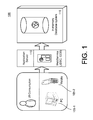
FIG. 1 illustrates a system having an in-memory database system according to an embodiment;
FIG. 2 illustrates the in-memory database system according to an embodiment;
FIG. 3 depicts a flow chart illustrating example operations of the in-memory database system of FIGS. 1 and 2 according to an embodiment;
FIG. 4 depicts a flow chart illustrating example operations of the in-memory database system of FIGS. 1 and 2 according to another embodiment; and
FIG. 5 illustrates the in-memory database system according to another embodiment.
DETAILED DESCRIPTION
The embodiments provide an in-memory database system that may provide real-time extraction capabilities along with geoprocessing capabilities including geocoding and geoprocessing. For example, the in-memory database system may receive data from a plurality of different data sources, consolidate the data in real time (or near real time), and geocode the appropriate address data from the consolidated data, thereby obtaining spatial data such as longitude and latitude information, for example, which are then stored in the in-memory database system. Further, the in-memory database system provides geoprocessing calculation capabilities that are performed in-memory, which may increase the calculation performance. In other words, because the geographical processing logic is transferred into the in-memory database level, all the calculations are performed in-memory which may increase the calculation performance. Further, comparing with the traditional three-tier architecture of a software application, because the middle layer is relatively thin (e.g., the application server layer), the reduced network communication from the application server to the in-memory database may help improve the calculation performance and potentially reduce the deployment complexity and configuration management issues.
FIG. 1 illustrates a system 100 having an in-memory database system 115 according to an embodiment. For example, the system 100 includes a plurality of devices 105 such as a personal computer 105-1 and a mobile unit 105-2, an application server 110 providing one or more web services, and the in-memory database 115. Each device 105 may be any type of computing device having one or more processors and memory units, and the application server 110 may encompass any type of application server known in the art. Information may be exchanged between the devices 105 and the application 110, as well as the application server 110 and the in-memory database 115 according to methods that are well known in the art.
The in-memory database system 115 may be a type of database system that supports real-tem analytics and transactional processing. For example, the in-memory database system 115 may include a parallel processing data store that utilizes row-based, column-based, and/or object-based storage techniques. In one embodiment, the in-memory database system 115 may be HANA Enterprise 1.0 (any other versions) that is developed by SAP. As further explained below, the in-memory database system 115 may be equipped with geocoding and geoprocessing, which are performed at the in-memory database level as opposed to an application server level. It is noted that the in-memory database system 115 not only supports storing geographical information (e.g., GIS reference tables and spatial data) but also capabilities of executing geographical processing (e.g., spatial inquires). As a result, a user may be able to obtain more meaningful, in-depth content from the relatively large amount of extracted data. Also, as shown in FIG. 1, because the geocoding and geoprocessing calculation are performed at the in-memory database system level, the application server level can be relatively thin.
FIG. 2 illustrates the in-memory database system 115 according to an embodiment. The in-memory database system 115 may include a geoprocessing module 120, a geocoding module 130, an extraction module 136, and a modeling module 146. The in-memory database system 115 may include other components known to one of ordinary skill in the art. The in-memory database system 115 may receive data from a plurality of external data sources 152 such as a database 152-1, an XML file 152-2, an Excel file 152-3, an Access file 152-4 and well as any other type of files 152-2. As shown in FIG. 2, the in-memory database system 115 may receive data having a number of different formats. The data may be any type of data relevant to the web service provided by the application server 110, which may include business data (e.g., master data and/or transactional data) and associated address data. The geoprocessing module 120, the geocoding module 130, the extraction module 136, and the modeling module 146 may be located in the same database tier. For example, referring to a three-tier application architecture, a web service may be implemented across a web (user) application tier, a server application tier, and a database tier. Conventionally, most of the computations are performed in the server application tier, and the database tier typically is associated with a storage unit for the storage of non-spatial data. However, according to the embodiment, the geocoding and/or geoprocessing functions are transferred to the database tier, which also includes the non-spatial data that is stored with the spatial data.
The extraction module 136 may be configured to extract the data from one or more of the external data sources 152, and transform the data into a standard format. Again, the data may include business data including master data and/or transactional data. The extraction module 136 may include a data services unit 138 having a data quality unit 140, batch jobs 142 and real time jobs 144. The data from the different external data sources 152 having different formats may be cleaned, merged and transformed through the data services unit 138. The data services unit 138 may provide connectivity to databases, applications, legacy systems and file formats, and the data may be extracted, transformed and loaded into the in-memory database system 115 through jobs such as the batch jobs 142 and/or the real time jobs 144. The extraction, transformation, and loading may be referred as an extract, transform, load (ETL) operation. However, the embodiments encompass any type of extraction and translation method known to one of ordinary skill in the art. The extraction module 136 may extract the data from the one or more external data sources 152 in real-time via one or more real time jobs 114, and/or the extraction module 136 may extract the data from the one or more external data sources 152 in time intervals via one or more batch jobs 142. With respect to the batch jobs 142, each batch job 142 may be scheduled to run at a certain start time, or time interval for delta uploads. In other words, the collection of data may be performed according to two different types of methods—real-time mode or batch mode. In the batch mode, the data is collected via the batch jobs 142, which collects all the data from the external data sources 152 during a set time interval. The set time interval may be adjusted, configured, or modified depending on how often data is collected. In contrast, in the real time mode, the extraction module 136 may collected the data from the data sources 152 in real time or near real time, as the information is being consumed in the data sources 152.
The data quality unit 140 may be configured to clean and merge the data into the standard format. The standard format may be a format corresponding to the format used by the in-memory database system 115. Within the ETL process, the data quality unit 140 may clean and merge the data using defined data quality control packages or self-contained logic. Also, if the data quality unit 140 recognizes address information among the data, the data quality unit 140 may perform an address cleaning process on the address information. After the data is cleaned and merged, the data may be stored in an internal database 150, as shown in the modeling module 146. However, if the data includes address data that needs to be geocoded, a geocoding process is trigged in which the address data is first provided to the geocoding module 130, which geocodes the address data and provides the geocoded address data to the internal database 150. In other words, after the extraction mode 136 has extracted, cleaned and transformed the inputted data, if address data is discovered, the geocoding process is triggered. In one embodiment, the extraction module 136 may provide a status message and/or test message for the completion of the data quality processes for each data services job (e.g., batch job 142 or real time job 144), and the extraction module 136 may mark the appropriate status message and/or test message as including address data when the corresponding job includes such information. The status of the extracting module 136 is monitored by the geocoding module 130 (e.g., the job status monitor 133) as further explained below. Also, as shown in FIG. 2, the internal database 150 may store data 150A and spatial data 150B, as well as any internal reference tables (e.g., internal reference tables 134). The data 150A may represent any type of data extracted from the extraction module 136 such as the business data (e.g., the master data and/or the transactional data), and the spatial data 150B may represent the spatial content obtained from the geocoding module 130, as further explained below.
The geocoding module 130 may be configured to geocode the address data including obtaining spatial data based on the address data using one or more internal reference tables 134. Although the internal database tables 134 are illustrated in FIG. 2 as being associated with the geocoder portion and the data 150A and the spatial data 150B are illustrated with respect to the internal database 150, the internal reference tables 134 are actually stored within the same database as the data 150A and the spatial data 150B—e.g., the internal database 150. The geocoding module 130 may include a geocoder 132 that is configured to geocode the address data, a job status monitor 133 that is configured to monitor a status of extracting and transforming by the extraction module 136 (e.g., whether the batch job 142 or the real time job 142 is completed), and the internal reference tables 134. The internal reference tables 134 may be a Worldwide GIS reference table(s) or any type of table(s) that stores regional or world map information. To model a geographical landscape, the internal reference tables 134 may use different kinds of geometric entities such as points, polylines and/or polygons to abstract and describe the real surface features such as roads, rivers and land blocks on the earth, for example. The construction of such internal reference tables 134 are known in the art.
The job status monitor 133 may be configured to monitor the status of extracting and transforming by the extraction module 136, and determine whether or not address data is contained in the extracted data. If address data is contained in the extracted data, the geocoder 132 may be configured to query the internal reference tables 134 using the address data as determined by the job status monitor 133, determine matching address data in the internal reference table 143, and obtain corresponding spatial data from the internal reference tables 134. The spatial data 150B may include longitude and latitude information corresponding to the address data, as well as any other type of information that spatially describes address data. The job status monitor 133 may be configured to monitor each job (e.g., batch job 142 and real time job 144) by checking the job status according to a specific time interval or in real time. One the extraction and transformation process is successfully completed, the job status monitor 133 may determine that address data is included in the extracted data by the status message and/or the test message being marked as including address data. Thereafter, the geocoding module 130 may filter out all the address data and trigger the geocoding process. As indicated above, the internal reference tables 134 may be stored in the internal database 150 of the in-memory database system 115, where the geocoder 132 queries all data in the internal reference tables 134 for each input address data to obtain a match point such as an address match and/or zip code match to determine the address point's most approximate coordinates. Then the returned spatial data 150B in stored directly in the in-memory database 115 such as in the internal database 150. Now, the business data 150A and the spatial data 150B are ready in the in-memory database system 115 for further calculation or processing as described below.
The geoprocessing module 120 may be configured to geographically process the spatial data 150B according to spatial procedure information including performing one or more spatial queries on the spatial data 150B according to the spatial procedure information. The spatial procedure information may be computer-readable code that specifies a number of geoprocessing operations. The spatial procedure information is further illustrated in FIG. 5 (e.g., spatial procedure information 160). In one embodiment, the geoprocessing module 120 may provide a development interface 122 for developing one or more geoprocesses including a topology 124, a spatial query 126, and projections 128, for example. Each of the topology 124, the spatial query 126 and the projections 128 may represent a subset of geoprocessing processes. The spatial query 126 may include functions such as spatial_intersects, spatial_within, spatial_overlap, spatial_contains, and/or find_nearest, for example. The topology 124 may represent topology operations between the geometric entities such as calculating intersection points, which is a common topology operation. Further, the projections 128 may represent any type of projection calculation known in the art. The topology 124, the spatial query 126, and the projections 128 may be defined by the spatial procedure information. In one embodiment, the geoprocessing module 120 may be configured to transmit results of the above operations to an outside GIS application for further processing. For example, the outside GIS application may provide a graphical display of the result information on an application display component. Alternatively, the results of the calculations may be used internally to generate a number of different views provided by the modeling module 146, which are further explained below.
In one embodiment, the spatial data 150B is stored in the internal database 150 having a column based format, which may permit a higher compression ratio and processing speed. In addition, the non-spatial data (e.g., the data 150A) is also stored in the same database with the spatial data 150B. As such, the geoprocessing module 120 may perform geoprocessing on the data 150A and the spatial data 150B jointly. In one example, a user may be able to analyze the relationship between location and sales amount, so that the user can choose a best location to expand a new branch store. The geoprocessing module 120 may transfer the results to the user interface component for display, which is independent of outside GIS vendors. Also, the geoprocessing module 120 may perform multi-thread calculations using multiple processors and core computers. Also, parallelization can significantly improve the performance during such calculations.
The modeling module 146 may be configured to create database views for the data 150A and the spatial data 150B stored in the internal database 150. The database views may include an attribute view, an analytic view and/or calculation view, for example, which are further illustrated in FIG. 5. In other words, depending on the calculation logic, a user may create procedures or different views to push the calculation into the in-memory database system 115.
FIG. 3 is a flowchart illustrating example operations of the in-memory database system 115 of FIGS. 1 and 2 according to an embodiment. Although FIG. 3 is illustrated as a sequential, ordered listing of operations, it will be appreciated that some or all of the operations may occur in a different order, or in parallel, or iteratively, or may overlap in time.
Data from one or more external data sources may be extracted and transformed into a standard format (302). For example, the extraction module 136 may extract data from the one or more external data sources 152, and transform the data into a standard format. The data may include business data and address data. The extraction module 136 may include the data services unit 138 having a data quality unit 140, batch jobs 142 and real time jobs 144. The data from the different external data sources 152 having different formats may be cleaned, merged and transformed through the data services unit 138. The extraction, transformation, and loading may be referred as an extract, transform, load (ETL) operation, which is a term commonly used for such data gathering. However, the embodiments encompass any type of extraction and translation method known to one of ordinary skill in the art. The extraction module 136 may extract the data from the one or more external data sources 152 in real-time via one or more real time jobs 114, and/or the extraction module 136 may extract the data from the one or more external data sources 152 in time intervals via one or more batch jobs 142.
The address data may be geocoded, which may include obtaining spatial data based on the address using an internal reference table (304). For example, the geocoder 132 may geocode the address data including obtaining spatial data based on the address data using the internal reference tables 134. The gecoder 132 may be associated with the job status monitor 133 that monitors the status of extracting and transforming by the extraction module 136. Also, the job status monitor 133 may determine whether or not address data is contained in the extracted data. If address data is contained in the extracted data, the geocoder 132 may be configured to query the internal reference tables 134 using the address data as determined by the job status monitor 133, determine matching address data in the internal reference table 143, and obtain corresponding spatial data from the internal reference tables 134. The spatial data 150B may include longitude and latitude information corresponding to the address data, as well as any other type of information that spatially describes address data. The job status monitor 133 may be configured to monitor each job (e.g., batch job 142 and real time job 144) by checking the job status according to a specific time interval or in real time. One the extraction and transformation process is successfully completed, the job status monitor 133 may determine that address data is included in the extracted data by the status message and/or the test message being marked as including address data. Thereafter, the geocoding module 130 may filter out all the address data and trigger the geocoding process.
The internal reference tables 134, the business data, the address data and the spatial data may be stored in an internal database (306). For example, the internal database 150 may store the internal reference tables 134, the business data, the address data, and the spatial data.
FIG. 4 is a flowchart illustrating example operations of the in-memory database system 115 of FIGS. 1 and 2 according to an embodiment. Although FIG. 4 is illustrated as a sequential, ordered listing of operations, it will be appreciated that some or all of the operations may occur in a different order, or in parallel, or iteratively, or may overlap in time.
After a collection process is started (402), and extract, transform and load (ETL) process may be performed (404). For example, the extraction module 136 may perform the ETL process on the data from the one or more external data sources 152.
A job status is determined as completed (406). As explained above, after the extraction mode 136 has extracted, cleaned and transformed the inputted data, if address data is discovered, the geocoding process is triggered. The extraction module 136 may provide a status message and/or test message for the completion of the data quality processes for each data services job (e.g., batch job 142 or real time job 144), and the extraction module 136 may mark the appropriate status message and/or test message as including address data when the corresponding job includes such information. The job status monitor 133 may be configured to monitor the status of extracting and transforming by the extraction module 136. In particular, the job status monitor 133 is configured to monitor each job by checking the job status, via the status message and/or the test message.
Once the ETL process is complete, the address data is determined as being included in the extracted data (408). For example, once the extraction and transformation process is successfully completed, the job status monitor 133 may determine that the address data is included in the extracted data by the status message and/or the test message being marked. If address data is determined as being included in the extracted data, the processing proceeds to 410. If address data is not determined as being included in the extracted data, the process is ended (414).
Once address data is determined as being included in the extracted data, the address data is selected (410) and geocoded (412). For example, the geocoding module 130 may be configured to geocode the address data including obtaining spatial data based on the address data using an internal reference database 134.
FIG. 5 illustrates the in-memory database 115 according to another embodiment. For example, the in-memory database system 115 may include spatial procedures 160, the spatial data 150B and the business data 150A such as the master data 150A and the transactional data 150A, regular procedures 168, and the various different views such as the attribute views 162, analytical views 164, and the calculation views 166. The spatial procedures are procedures that relate to geoprocessing (e.g., using the geoprocessing module 120), and the regular procedures 164 relate to conventional data processing techniques. For example, the geoprocessing module 120 may be configured to geographically process the spatial data 150B according to the spatial procedure information 160, which may include performing one or more spatial queries 126 on the spatial data 150B according to the spatial procedure information 160.
According to one example, suppose a user wants to calculate the intersection points between a road network of China and a specific line. In the road network, there may be over 3.7 million features, so the amount of calculation is relatively large. In the traditional database, the processing speed is relatively slow. However, performing such a calculation in the in-memory database 115 according to the embodiments, the calculations may be performed significantly quicker (e.g., appropriately 157 seconds) to obtain all the intersection points.
For example, the extraction module 136 may be used to import the map data into the in-memory database 115, which is then stored as the internal reference table 134 as two-dimensional tables, e.g., one is to store the attribute data, such as the name of the road segment, and the other one is to store spatial data such as the coordinates of each vertex from the road segment polyline. The two tables may share the same primary key to record the mapping relationship. Here, because the internal reference table 134 may utilize column-based storage mechanism, the memory and disk space cost would be smaller than traditional databases.
As explained above, the in-memory database system 115 not only stores the spatial data 15A, but also includes capabilities of geographical processing in the same tier. Together with the in-memory technology, the in-memory database system 115 may reduce the unnecessary time cost in network transportation and disk space. In addition, L language based multithread processing may also speed up the procedure. The HASH partitioning mechanism is used to make the column table into several partitions according to the core number of the server. The program determines the intersection situation between each road segment and the specific line. Below is a sample of the spatial procedures 160 that is used to carry out such a calculation.
CREATE FUNCTION GIS.SPATIAL
 ( IN SPATIAL String, IN PXS Double, IN PYS Double, IN PXE Double,
 IN PYE
Double)
 RETURNS “Distance” Double
 LANGUAGE LLANG
 AS
 BEGIN
  export Void main( String “SPATIAL” sp, Double “PXS” pxs, Double
“PYS” pys, Double “PXE” pxe, Double “PYE” pye, Double “Distance”
&distance)
  {
   Double ox = Double(0);
   Double oy = Double(0);
   distance = Double(0);
   Bool ints = Bool(false);
   /* get first segment */
   String p1 = sp.substring7Bit(Size(0),sp.indexOf(“/”));
   Double px1 = Double(p1.substring7Bit(Size(0),p1.indexOf(“,”)));
   Double py1 =
Double(p1.substring7Bit(Size(Int32(p1.indexOf(“,”))+1),
Size(Int32(p1.getLength())-Int32(p1.indexOf(“,”))−1)));
   String tempsp =
sp.substring7Bit(Size(Int32(sp.indexOf(“/”))+1),Size(Int32(sp.getLength())-
Int32(sp.indexOf(“/”))−1));
   String p2 = tempsp.substring7Bit(Size(0),tempsp.indexOf(“/”));
   Double px2 = Double(p2.substring7Bit(Size(0),p2.indexOf(“,”)));
   Double py2 =
Double(p2.substring7Bit(Size(Int32(p2.indexOf(“,”))+1),
Size(Int32(p2.getLength())-Int32(p2.indexOf(“,”))−1)));
   /* calculate the distance between the point to the segment */
   if (
   math::max(pxs,pxe) >= math::min(px1,px2) &&
   math::max(px1,px2) >= math::min(pxs,pxe) &&
   math::max(pys,pye) >= math::min(py1,py2) &&
   math::max(py1,py2) >= math::min(pys,pye) &&
   ((px1-pxs)*(pye-pys) − (pxe-pxs)*(py1-pys)) *
   ((pxe-pxs)*(py2-pys) − (px2-pxs)*(pye-pys)) >= Double(0) &&
   ((pxs-px1)*(py2-py1) − (px2-px1)*(pys-py1)) *
   ((px2-px1)*(pye-py1) − (pxe-px1)*(py2-py1)) >= Double(0) ){
   /* there's intersections, calculation the intersect posibiton */
   ints = Bool(true);
   ox = ((pxs-pxe)*(px1*py2 - px2*py1) − (px1-px2) * (pxs*pye -
pxe*pys))/((px1-px2)*(pys-pye)−(pxs-pxe)*(py1-py2));
   oy = ((pys-pye)*(px1*py2 - px2*py1) − (pxs*pye - pxe*pys)*(py1 -
py2)) / ((pys-pye)*(px1-px2) − (pxs-pxe)*(py1-py2));
   distance =
Double(String(math::round(DecFloat34(ox),0)).append(“.”).append(String
(math::round(DecFloat34(oy),0))));
   }
   while ( !ints && tempsp.indexOf(“/”) != tempsp.getLength( ))
   {
    p1 = p2;
    px1 = px2;
    py1 = py2;
    tempsp =
tempsp.substring7Bit(Size(Int32(tempsp.indexOf(“/”))+1),
Size(Int32(tempsp.getLength( ))-Int32(tempsp.indexOf(“/”))−1));
    p2 = tempsp.substring7Bit(Size(0),tempsp.indexOf(“/”));
    px2 = Double(p2.substring7Bit(Size(0),p2.indexOf(“,”)));
    py2 =
Double(p2.substring7Bit(Size(Int32(p2.indexOf(“,”))+1),
Size(Int32(p2.getLength( ))-Int32(p2.indexOf(“,”))−1)));
    if (
    math::max(pxs,pxe) >= math::min(px1,px2) &&
    math::max(px1,px2) >= math::min(pxs,pxe) &&
    math::max(pys,pye) >= math::min(py1,py2) &&
    math::max(py1,py2) >= math::min(pys,pye) &&
    ((px1-pxs)*Double(pye-pys) − (pxe-pxs)*(py1-pys)) *
    ((pxe-pxs)*Double(py2-pys) − (px2-pxs)*(pye-pys)) >=
Double(0) &&
    ((pxs-px1)*Double(py2-py1) − (px2-px1)*(pys-py1)) *
    ((px2-px1)*Double(pye-py1) − (pxe-px1)*(py2-py1)) >=
Double(0) ){
    /* there's intersections, calculation the intersect posibiton */
    ints = Bool(true);
    ox = ((pxs-pxe)*(px1*py2 - px2*py1) − (px1-px2) *
(pxs*pye - pxe*pys))/((px1-px2)*(pys-pye)−(pxs-pxe)*(py1-py2));
    oy = ((pys-pye)*(px1*py2 - px2*py1) − (pxs*pye -
pxe*pys)*(py1-py2)) / ((pys-pye)*(px1-px2) - (pxs-pxe)*(py1-py2));
    distance =
Double(String(math::round(DecFloat34(ox),0)).append(“.”).append(String
(math::round(DecFloat34(oy),0))));
    }
   }
  }
 END;
In summary, the in-memory database system 115 supports storing both attribute data and spatial data together in the same database, as well as joint processing operating on both the attribute data and the spatial data. Also, the in-memory database system 115 supports on-the-fly data consolidation from different data sources, batch geocoding, and reverse geocoding between descriptive address data and the geographic coordinates. The in-memory database system 115 may improve the geographic processing performance based on in-memory and parallel computing technology. Also, the in-memory database system 115 may reduce the landscape complexity by putting the calculation logic for the business data and/or the spatial data into the database level, thereby reducing the interaction between the middle layer (e.g. application) and the database layer, which in return may improve the whole application performance as well as reduce deployment effort.
Implementations of the various techniques described herein may be implemented in digital electronic circuitry, or in computer hardware, firmware, software, or in combinations of them. Implementations may implemented as a computer program product, i.e., a computer program tangibly embodied in an information carrier, e.g., in a machine-readable storage device or in a propagated signal, for execution by, or to control the operation of, data processing apparatus, e.g., a programmable processor, a computer, or multiple computers. A computer program, such as the computer program(s) described above, can be written in any form of programming language, including compiled or interpreted languages, and can be deployed in any form, including as a stand-alone program or as a module, component, subroutine, or other unit suitable for use in a computing environment. A computer program can be deployed to be executed on one computer or on multiple computers at one site or distributed across multiple sites and interconnected by a communication network.
Method steps may be performed by one or more programmable processors executing a computer program to perform functions by operating on input data and generating output. Method steps also may be performed by, and an apparatus may be implemented as, special purpose logic circuitry, e.g., an FPGA (field programmable gate array) or an ASIC (application-specific integrated circuit).
Processors suitable for the execution of a computer program include, by way of example, both general and special purpose microprocessors, and any one or more processors of any kind of digital computer. Generally, a processor will receive instructions and data from a read-only memory or a random access memory or both. Elements of a computer may include at least one processor for executing instructions and one or more memory devices for storing instructions and data. Generally, a computer also may include, or be operatively coupled to receive data from or transfer data to, or both, one or more mass storage devices for storing data, e.g., magnetic, magneto-optical disks, or optical disks. Information carriers suitable for embodying computer program instructions and data include all forms of non-volatile memory, including by way of example semiconductor memory devices, e.g., EPROM, EEPROM, and flash memory devices; magnetic disks, e.g., internal hard disks or removable disks; magneto-optical disks; and CD-ROM and DVD-ROM disks. The processor and the memory may be supplemented by, or incorporated in special purpose logic circuitry.
To provide for interaction with a user, implementations may be implemented on a computer having a display device, e.g., a cathode ray tube (CRT) or liquid crystal display (LCD) monitor, for displaying information to the user and a keyboard and a pointing device, e.g., a mouse or a trackball, by which the user can provide input to the computer. Other kinds of devices can be used to provide for interaction with a user as well; for example, feedback provided to the user can be any form of sensory feedback, e.g., visual feedback, auditory feedback, or tactile feedback; and input from the user can be received in any form, including acoustic, speech, or tactile input.
Implementations may be implemented in a computing system that includes a back-end component, e.g., as a data server, or that includes a middleware component, e.g., an application server, or that includes a front-end component, e.g., a client computer having a graphical user interface or a Web browser through which a user can interact with an implementation, or any combination of such back-end, middleware, or front-end components. Components may be interconnected by any form or medium of digital data communication, e.g., a communication network. Examples of communication networks include a local area network (LAN) and a wide area network (WAN), e.g., the Internet.
While certain features of the described implementations have been illustrated as described herein, many modifications, substitutions, changes and equivalents will now occur to those skilled in the art. It is, therefore, to be understood that the appended claims are intended to cover all such modifications and changes as fall within the scope of the embodiments.

Claims (22)

What is claimed is:
1. A system including instructions recorded on a non-transitory computer-readable medium and executable by at least one processor, the system comprising:
an in-memory database configured to interface with an application server hosting one or more web services, the in-memory database configured to perform extract, transform, and load (ETL) operations to collect data from one or more external data sources and perform geocoding and geoprocessing on the data such that the geocoding and geoprocessing are not performed at the application server but rather at a database level represented by the in-memory database, the in-memory database including,
an extraction module configured to cause the at least one processor to perform the ETL operations including extracting the data from the one or more external data sources, and transforming the data into a standard format associated with the in-memory database, the data including business data and address data;
a geocoder configured to cause the at least one processor to geocode the address data including obtaining spatial data based on the address data using an internal reference table stored in the in-memory database, the spatial data including geographical coordinate data corresponding to the address data; and
a geoprocessing module configured to cause the at least one processor to geographically process the spatial data including calculating geographical topology information using the geocoded address data including the geographical coordinate data; and
a storage configured to store the spatial data and the business data.
2. The system of claim 1, wherein the extraction module is configured to extract the data from the one or more external data sources in real-time via one or more real-time jobs.
3. The system of claim 1, wherein the extraction module is configured to extract the data from the one or more external data sources in time intervals via one or more batch jobs.
4. The system of claim 1, wherein the extraction module includes:
a data quality unit configured to clean and merge the data into the standard format.
5. The system of claim 1, wherein the data from the one or more external data sources includes data having different formats.
6. The system of claim 1, wherein the geocoder configured to geocode the address data includes:
a job status monitor configured to monitor a status of the ETL operations of by the extraction module,
the job status monitor configured to determine that the address data is contained in the extracted data,
wherein the geocoder is configured to query the internal reference table using the address data as determined by the job status monitor, determine matching address data in the internal reference table, and obtain corresponding spatial data from the internal reference table.
7. The system of claim 1, wherein the spatial data includes longitude and latitude information corresponding to the address data.
8. The system of claim 1, wherein the storage of the in-memory database includes a column-based storage, a row-based storage, and an object-based storage, the spatial data being stored in the column-based storage.
9. The system of claim 1, wherein the geoprocessing module is configured to geographically process the spatial data according to spatial procedure information including performing one or more spatial queries on the spatial data according to the spatial procedure information.
10. The system of claim 9, wherein the geoprocessing module is configured to transmit results of the one or more spatial queries to an outside geographic information system (GIS) application for further processing.
11. The system of claim 1, wherein the geoprocessing module, the extraction module, the geocoder, and the storage are located in a same database tier.
12. The system of claim 1, wherein the in-memory database further includes:
a modeling module configured to create database views for the business data and the spatial data stored in the storage, the database views including at least one of an attribute view, analytic view and calculation view.
13. The system of claim 12, wherein the modeling module is configured to transmit one or more database views to a user interface component for display.
14. The system of claim 1, wherein the spatial data includes earth based real surface feature information, earth based geographical coordinate information, world map information, and regional map information corresponding to the address data.
15. The system of claim 1, wherein calculating geographical topology information includes calculating intersection points between one or more real surface features and a specific line using the geocoded address data including the geographical coordinate data.
16. A method for geocoding address data by an in-memory database, the method comprising:
performing, by an in-memory database, extract, transform, and load (ETL) operations, on data from one or more external data sources including transforming the data into a standard format associated with the in-memory database;
triggering, by the in-memory database, a geocoding process if address data is discovered within the data;
geocoding, by the in-memory database, the address data including obtaining spatial data based on the address data using a geographical information system (GIS) table stored in the in-memory database such that the geocoding is performed at a database level represented by the in-memory database as opposed to an application server, the spatial data including geographical coordinate data corresponding to the address data;
geographically processing, by the in-memory database, the spatial data including calculating geographical topology information using the geocoded address data including the geographical coordinate data such that the geographically processing is performed at the database level as opposed to the application server; and
storing the spatial data and the data in a storage of the in-memory database.
17. The method of claim 16, wherein the performing the ETL operations include extracting the data from the one or more external data sources in real-time via one or more real-time jobs.
18. The method of claim 16, wherein the performing the ETL operations include extracting the data from the one or more external data sources in time intervals via one or more batch jobs.
19. The method of claim 16, wherein the geographically processing includes geographically processing the spatial data according to spatial procedure information including performing one or more spatial queries on the spatial data according to the spatial procedure information.
20. The method of claim 16, further comprising:
creating, by the in-memory database, database views for the data and the spatial data stored in the storage of the in-memory database, the database views including at least one of an attribute view, analytic view and calculation view.
21. A computer program product tangibly embodied on a non-transitory computer-readable storage medium and including executable code that, when executed, is configured to cause at least one processor to:
perform, by an in-memory database, extract, transform, and load (ETL) operations on business data from one or more data sources including executable code to extract the business data from the one or more external data sources and transform the business data into a format associated with the in-memory database;
trigger, by the in-memory database, a geocoding process if address data is discovered within the extracted business data;
geocode, by the in-memory database, the address data including obtaining spatial data based on the address data using a map reference table stored in the in-memory database such that the geocoding is performed at a database level represented by the in-memory database as opposed to an application server, the spatial data including geographical coordinate data corresponding to the address data; and
perform, by the in-memory database, geoprocessing on the business data and the spatial data jointly such that correlations between locations and the business data are derived, the geoprocessing being performed at the database level as opposed to the application server.
22. The computer program product of claim 21, wherein the business data includes sales data associated with existing locations, and the derived correlations predict one or more new locations based on the sales data.
US13/675,871 2012-05-02 2012-11-13 In-memory spatial database for geocoding/geoprocessing Active 2033-02-05 US8996545B2 (en)

Applications Claiming Priority (3)

Application Number Priority Date Filing Date Title
CN201210135239.0 2012-05-02
CN201210135239 2012-05-02
CN201210135239.0A CN103383688B (en) 2012-05-02 2012-05-02 Memory headroom database for geocoding/geography processing

Publications (2)

Publication Number Publication Date
US20130297556A1 US20130297556A1 (en) 2013-11-07
US8996545B2 true US8996545B2 (en) 2015-03-31

Family

ID=49491478

Family Applications (1)

Application Number Title Priority Date Filing Date
US13/675,871 Active 2033-02-05 US8996545B2 (en) 2012-05-02 2012-11-13 In-memory spatial database for geocoding/geoprocessing

Country Status (2)

Country Link
US (1) US8996545B2 (en)
CN (1) CN103383688B (en)

Cited By (7)

* Cited by examiner, † Cited by third party
Publication number Priority date Publication date Assignee Title
CN104881465A (en) * 2015-05-26 2015-09-02 北京挺软科技有限公司 Method and system for achieving read-only main memory database
US9264857B1 (en) * 2013-10-15 2016-02-16 Google Inc. Compact codes for geographic locations
US20180131763A1 (en) * 2016-11-04 2018-05-10 Sap Se Framework for data geocoding
US10616412B1 (en) 2017-12-20 2020-04-07 Geo-Comm, Inc. Processing an emergency services call
US10771551B2 (en) 2017-03-28 2020-09-08 Sap Se Dynamic topology switch for data replication
US10915544B2 (en) * 2015-09-11 2021-02-09 International Business Machines Corporation Transforming and loading data utilizing in-memory processing
US10928202B2 (en) 2016-12-30 2021-02-23 Geo-Comm Inc. System and methods for three-dimensional volumetric indoor location geocoding

Families Citing this family (10)

* Cited by examiner, † Cited by third party
Publication number Priority date Publication date Assignee Title
US20090198954A1 (en) * 2008-02-01 2009-08-06 Electronic Data Systems Corporation Method and system for generating location codes
US9031579B2 (en) * 2012-10-01 2015-05-12 Mastercard International Incorporated Method and system for providing location services
US9110935B2 (en) * 2013-02-26 2015-08-18 Sap Se Generate in-memory views from universe schema
US10181107B2 (en) * 2014-06-25 2019-01-15 Oracle International Corporation Using consumption data and an inventory model to generate a replenishment plan
US10002364B2 (en) 2014-06-25 2018-06-19 Oracle International Corporation Consumption-driven forecasting using multi-level heterogeneous input data
CN105022770B (en) * 2015-01-07 2019-01-25 泰华智慧产业集团股份有限公司 A kind of Geocoding and system based on smart city
US9912545B2 (en) * 2015-03-20 2018-03-06 International Business Machines Corporation High performance topology resolution for non-instrumented nodes
CN106611060A (en) * 2016-12-29 2017-05-03 苏碧云 Data processing method for GIS
CN106649802A (en) * 2016-12-29 2017-05-10 广东精规划信息科技股份有限公司 Address cloud service platform
CN111435360B (en) * 2019-01-15 2023-08-29 菜鸟智能物流控股有限公司 Address type identification method and device and electronic equipment

Citations (15)

* Cited by examiner, † Cited by third party
Publication number Priority date Publication date Assignee Title
US5796634A (en) * 1997-04-01 1998-08-18 Bellsouth Corporation System and method for identifying the geographic region of a geographic area which contains a geographic zone associated with a location
US5961572A (en) * 1997-04-01 1999-10-05 Bellsouth Intellectual Property Corporation System and method for identifying the geographic region of a geographic area which contains a geographic point associated with a location
US5991739A (en) * 1997-11-24 1999-11-23 Food.Com Internet online order method and apparatus
US6134677A (en) * 1995-12-04 2000-10-17 Micron Technology, Inc. Method and apparatus for testing memory devices and displaying results of such tests
US20030225725A1 (en) * 2001-05-31 2003-12-04 Miller Julia K. System and method for geocoding diverse address formats
US20050137994A1 (en) * 2000-06-05 2005-06-23 Fortin Stephen E. High-performance location management platform
US20050261823A1 (en) * 2004-05-20 2005-11-24 Haitao Huang Intelligent geocoding of location information
US20060100912A1 (en) * 2002-12-16 2006-05-11 Questerra Llc. Real-time insurance policy underwriting and risk management
US20090063254A1 (en) * 2007-08-24 2009-03-05 Deirdre Paul Method and apparatus to identify influencers
US20090063453A1 (en) * 2007-08-29 2009-03-05 International Business Machines Corporation Apparatus, system, and method for executing a distributed spatial data query
US20090276450A1 (en) * 2008-05-05 2009-11-05 West Corporation Method and system for establishing a spatial street address data set
US7617246B2 (en) * 2006-02-21 2009-11-10 Geopeg, Inc. System and method for geo-coding user generated content
US20110161320A1 (en) * 2009-12-29 2011-06-30 Mckesson Financial Holdings Limited Methods, apparatuses, and computer program products for geocoding data
US20110161334A1 (en) * 2009-12-28 2011-06-30 Verizon Patent And Licensing, Inc. Translating and geocoding addresses
US8065076B2 (en) * 2007-04-13 2011-11-22 United Parcel Service Of America, Inc. Systems, methods, and computer program products for generating reference geocodes for point addresses

Family Cites Families (3)

* Cited by examiner, † Cited by third party
Publication number Priority date Publication date Assignee Title
CN101075247A (en) * 2007-06-22 2007-11-21 上海众恒信息产业有限公司 System and method for allocating service of geographical information system
US8171014B2 (en) * 2007-08-29 2012-05-01 International Business Machines Corporation Apparatus, system, and method for executing a distributed spatial data query
US8331958B2 (en) * 2007-12-13 2012-12-11 Garmin Switzerland Gmbh Automatically identifying location information in text data

Patent Citations (20)

* Cited by examiner, † Cited by third party
Publication number Priority date Publication date Assignee Title
US6134677A (en) * 1995-12-04 2000-10-17 Micron Technology, Inc. Method and apparatus for testing memory devices and displaying results of such tests
US6330693B1 (en) * 1995-12-04 2001-12-11 Micron Technology, Inc. Method and apparatus for testing memory devices and displaying results of such tests
US5961572A (en) * 1997-04-01 1999-10-05 Bellsouth Intellectual Property Corporation System and method for identifying the geographic region of a geographic area which contains a geographic point associated with a location
US5978747A (en) * 1997-04-01 1999-11-02 Bellsouth Intellectual Property Corporation Method for identifying the geographic region of a geographic area which contains a geographic zone
US5796634A (en) * 1997-04-01 1998-08-18 Bellsouth Corporation System and method for identifying the geographic region of a geographic area which contains a geographic zone associated with a location
US5991739A (en) * 1997-11-24 1999-11-23 Food.Com Internet online order method and apparatus
US20050137994A1 (en) * 2000-06-05 2005-06-23 Fortin Stephen E. High-performance location management platform
US20030225725A1 (en) * 2001-05-31 2003-12-04 Miller Julia K. System and method for geocoding diverse address formats
US20060100912A1 (en) * 2002-12-16 2006-05-11 Questerra Llc. Real-time insurance policy underwriting and risk management
US20050261823A1 (en) * 2004-05-20 2005-11-24 Haitao Huang Intelligent geocoding of location information
US20100146397A1 (en) * 2006-02-21 2010-06-10 Edward Lee Koch System and method for geo-coding user generated content
US8447787B2 (en) * 2006-02-21 2013-05-21 Geopeg, Inc. System and method for geocoding content
US7617246B2 (en) * 2006-02-21 2009-11-10 Geopeg, Inc. System and method for geo-coding user generated content
US8065076B2 (en) * 2007-04-13 2011-11-22 United Parcel Service Of America, Inc. Systems, methods, and computer program products for generating reference geocodes for point addresses
US20090063254A1 (en) * 2007-08-24 2009-03-05 Deirdre Paul Method and apparatus to identify influencers
US20090063453A1 (en) * 2007-08-29 2009-03-05 International Business Machines Corporation Apparatus, system, and method for executing a distributed spatial data query
US7987218B2 (en) * 2008-05-05 2011-07-26 West Corporation Method and system for establishing a spatial street address data set
US20090276450A1 (en) * 2008-05-05 2009-11-05 West Corporation Method and system for establishing a spatial street address data set
US20110161334A1 (en) * 2009-12-28 2011-06-30 Verizon Patent And Licensing, Inc. Translating and geocoding addresses
US20110161320A1 (en) * 2009-12-29 2011-06-30 Mckesson Financial Holdings Limited Methods, apparatuses, and computer program products for geocoding data

Non-Patent Citations (1)

* Cited by examiner, † Cited by third party
Title
"Storage in a Relational Database Management System", Geodatabase, retrieved on Jan. 31, 2013 from www.esri.com/software/arcgis/geodatabase/storage-in-an-rdbms, 3 pages.

Cited By (10)

* Cited by examiner, † Cited by third party
Publication number Priority date Publication date Assignee Title
US9264857B1 (en) * 2013-10-15 2016-02-16 Google Inc. Compact codes for geographic locations
CN104881465A (en) * 2015-05-26 2015-09-02 北京挺软科技有限公司 Method and system for achieving read-only main memory database
US10915544B2 (en) * 2015-09-11 2021-02-09 International Business Machines Corporation Transforming and loading data utilizing in-memory processing
US10929417B2 (en) * 2015-09-11 2021-02-23 International Business Machines Corporation Transforming and loading data utilizing in-memory processing
US20180131763A1 (en) * 2016-11-04 2018-05-10 Sap Se Framework for data geocoding
US10673945B2 (en) * 2016-11-04 2020-06-02 Sap Se Framework for data geocoding
US10928202B2 (en) 2016-12-30 2021-02-23 Geo-Comm Inc. System and methods for three-dimensional volumetric indoor location geocoding
US10771551B2 (en) 2017-03-28 2020-09-08 Sap Se Dynamic topology switch for data replication
US11258852B2 (en) 2017-03-28 2022-02-22 Sap Se Dynamic topology switch for data replication
US10616412B1 (en) 2017-12-20 2020-04-07 Geo-Comm, Inc. Processing an emergency services call

Also Published As

Publication number Publication date
US20130297556A1 (en) 2013-11-07
CN103383688A (en) 2013-11-06
CN103383688B (en) 2018-11-02

Similar Documents

Publication Publication Date Title
US8996545B2 (en) In-memory spatial database for geocoding/geoprocessing
US11874855B2 (en) Parallel data access method and system for massive remote-sensing images
Flemons et al. A web-based GIS tool for exploring the world's biodiversity: The Global Biodiversity Information Facility Mapping and Analysis Portal Application (GBIF-MAPA)
CN111971666A (en) Dimension context propagation technology for optimizing SQL query plan
CN103678705B (en) A kind of VCT file is to the vector data Parallel transformation method of shapefile file
CN103425723A (en) Deleting records in a multi-level storage architecture without record locks
CN103425722A (en) Logless atomic data movement
DE112018004214T5 (en) Scalable merging of space-time density data
Zhang et al. U2STRA: High-performance data management of ubiquitous urban sensing trajectories on GPGPUs
Giuliani et al. Testing OGC Web Feature and Coverage Service performance: Towards efficient delivery of geospatial data
Jhummarwala et al. Parallel and distributed GIS for processing geo-data: an overview
Saraee et al. A new data science framework for analysing and mining geospatial big data
Zhang et al. High-performance online spatial and temporal aggregations on multi-core cpus and many-core gpus
Rodriges Zalipynis ChronosDB in action: Manage, process, and visualize big geospatial arrays in the Cloud
Migliorini et al. An interoperable spatio-temporal model for archaeological data based on ISO standard 19100
Cerutti et al. Architectural heritage semantic data managing and sharing in GIS
Mohammed Free and Open Source GIS: an overview on the recent evolution of projects, standards and communities
Seah An application of a healthcare data warehouse system
Thasal et al. Information retrieval and de-duplication for tourism recommender system
Rodriges Zalipynis ChronosServer: Fast in situ processing of large multidimensional arrays with command line tools
Roy et al. In-database geospatial analytics using python
Brisaboa et al. Collecting and publishing large multiscale geographic datasets
Xiong et al. HiGIS: An open framework for high performance geographic information system
Ray High performance spatial and spatio-temporal data processing
Zhang et al. Distributed processing practice of the 3D city model based on HBase

Legal Events

Date Code Title Description
AS Assignment

Owner name: SAP SE, GERMANY

Free format text: CHANGE OF NAME;ASSIGNOR:SAP AG;REEL/FRAME:033625/0223

Effective date: 20140707

AS Assignment

Owner name: SAP AG, GERMANY

Free format text: ASSIGNMENT OF ASSIGNORS INTEREST;ASSIGNORS:CHEN, YINGYU;DONG, BIN;SHEN, YONGYUAN;REEL/FRAME:034031/0428

Effective date: 20121106

STCF Information on status: patent grant

Free format text: PATENTED CASE

MAFP Maintenance fee payment

Free format text: PAYMENT OF MAINTENANCE FEE, 4TH YEAR, LARGE ENTITY (ORIGINAL EVENT CODE: M1551); ENTITY STATUS OF PATENT OWNER: LARGE ENTITY

Year of fee payment: 4

MAFP Maintenance fee payment

Free format text: PAYMENT OF MAINTENANCE FEE, 8TH YEAR, LARGE ENTITY (ORIGINAL EVENT CODE: M1552); ENTITY STATUS OF PATENT OWNER: LARGE ENTITY

Year of fee payment: 8