US9024805B1 - Radar antenna elevation error estimation method and apparatus - Google Patents
Radar antenna elevation error estimation method and apparatus Download PDFInfo
- Publication number
- US9024805B1 US9024805B1 US13/627,788 US201213627788A US9024805B1 US 9024805 B1 US9024805 B1 US 9024805B1 US 201213627788 A US201213627788 A US 201213627788A US 9024805 B1 US9024805 B1 US 9024805B1
- Authority
- US
- United States
- Prior art keywords
- runway
- aircraft
- radar
- angle
- slope
- Prior art date
- Legal status (The legal status is an assumption and is not a legal conclusion. Google has not performed a legal analysis and makes no representation as to the accuracy of the status listed.)
- Active, expires
Links
- 238000000034 method Methods 0.000 title claims abstract description 119
- 238000012545 processing Methods 0.000 claims description 20
- 230000004044 response Effects 0.000 claims description 12
- 230000008569 process Effects 0.000 description 61
- 238000005259 measurement Methods 0.000 description 19
- 238000012937 correction Methods 0.000 description 16
- 238000013459 approach Methods 0.000 description 10
- 238000010586 diagram Methods 0.000 description 7
- 230000006870 function Effects 0.000 description 6
- 238000004364 calculation method Methods 0.000 description 5
- 238000004891 communication Methods 0.000 description 4
- 230000008901 benefit Effects 0.000 description 3
- 230000003416 augmentation Effects 0.000 description 2
- 230000005540 biological transmission Effects 0.000 description 2
- 230000003068 static effect Effects 0.000 description 2
- 230000001413 cellular effect Effects 0.000 description 1
- 238000012790 confirmation Methods 0.000 description 1
- 238000009795 derivation Methods 0.000 description 1
- 238000013461 design Methods 0.000 description 1
- 230000007257 malfunction Effects 0.000 description 1
- 238000012986 modification Methods 0.000 description 1
- 230000004048 modification Effects 0.000 description 1
- 238000006467 substitution reaction Methods 0.000 description 1
- 230000000007 visual effect Effects 0.000 description 1
Images


Classifications
-
- G—PHYSICS
- G01—MEASURING; TESTING
- G01S—RADIO DIRECTION-FINDING; RADIO NAVIGATION; DETERMINING DISTANCE OR VELOCITY BY USE OF RADIO WAVES; LOCATING OR PRESENCE-DETECTING BY USE OF THE REFLECTION OR RERADIATION OF RADIO WAVES; ANALOGOUS ARRANGEMENTS USING OTHER WAVES
- G01S5/00—Position-fixing by co-ordinating two or more direction or position line determinations; Position-fixing by co-ordinating two or more distance determinations
- G01S5/02—Position-fixing by co-ordinating two or more direction or position line determinations; Position-fixing by co-ordinating two or more distance determinations using radio waves
- G01S5/0247—Determining attitude
-
- G—PHYSICS
- G01—MEASURING; TESTING
- G01S—RADIO DIRECTION-FINDING; RADIO NAVIGATION; DETERMINING DISTANCE OR VELOCITY BY USE OF RADIO WAVES; LOCATING OR PRESENCE-DETECTING BY USE OF THE REFLECTION OR RERADIATION OF RADIO WAVES; ANALOGOUS ARRANGEMENTS USING OTHER WAVES
- G01S13/00—Systems using the reflection or reradiation of radio waves, e.g. radar systems; Analogous systems using reflection or reradiation of waves whose nature or wavelength is irrelevant or unspecified
- G01S13/88—Radar or analogous systems specially adapted for specific applications
- G01S13/882—Radar or analogous systems specially adapted for specific applications for altimeters
Definitions
- the present application relates generally to the field of altitude estimation systems. More specifically, the application relates to method for increased accuracy of altitude estimations.
- Altitude estimation systems conventionally provide flight crews with an estimation of an aircraft's current altitude.
- Altitude estimation systems may be implemented using barometer systems and/or global positioning systems (GPS).
- GPS global positioning systems
- Barometer and GPS based systems are subject to inaccuracies, limiting their usefulness during runway approach and landing.
- GPS and barometer based systems may lack the accuracy needed for reliable approach and landing estimations. For example, GPS based systems may only be accurate to within 200 feet without additional equipment.
- One embodiment of the present disclosure relates to a method of determining the altitude of an aircraft including radar data taken by an onboard radar system.
- the method includes receiving first data associated with an aircraft position.
- the method includes receiving second data associated with a position of a first point and a second point on the runway, and an altitude of the first point and the second point on the runway.
- the method includes receiving third data associated with radar returns from the runway.
- the method includes determining a first range between the aircraft and the first point on the runway and a second range between the aircraft and the second point on the runway, using the first and second data.
- the method includes determining a first angle between the first point on the runway and the aircraft, and a second angle between the second point on the runway and the aircraft, using the third data.
- the method includes determining a corrected angle relative to at least one of the first point and the second point.
- the method includes determining the altitude of the aircraft based on the corrected angle, the runway altitude of at least one of the first point and the second point, and at least one of the first range and the second range.
- the aircraft radar system includes an antenna.
- the aircraft radar system includes processing electronics configured to estimate a first slope of a runway.
- the processing electronics are also configured to compute a second slope of the runway.
- the processing electronics are also configured to estimate an error in the pointing angle of the antenna using the first slope and the second slope.
- the processing electronics are also configured to estimate an aircraft altitude using a range from the aircraft to the runway and a corrected angle between the aircraft and the runway, wherein the error in the pointing angle of the antenna is removed from the corrected angle.
- Yet another embodiment of the present disclosure relates to a method of determining the altitude of an aircraft including radar data taken by an onboard radar system.
- the method includes receiving first data associated with an aircraft position.
- the method includes receiving second data associated with positions of a plurality of points on the runway, and an altitude of the first point and the second point on the runway.
- the plurality of points on the runway includes a first point and a second point on the runway.
- the method includes receiving third data associated with radar returns from the runway.
- the method includes determining a plurality of ranges between the aircraft and the plurality of points on the runway.
- the plurality of ranges includes a first range between the aircraft and the first point on the runway and a second range between the aircraft and the second point on the runway, using the first and second data.
- the method includes determining a plurality of angles between the aircraft and the plurality of points, using the third data.
- the method includes determining a corrected angle relative to at least one of the plurality of points.
- the method includes determining an altitude of the aircraft based on the corrected angle, the runway altitude of at least one of the plurality of ranges and at least one of the plurality of ranges.
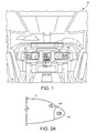
- FIG. 1 is an illustration of an aircraft control center, according to an exemplary embodiment
- FIG. 2A is an illustration view of the nose of an aircraft including the aircraft control center of FIG. 1 , according to an exemplary embodiment
- FIG. 2B is a block diagram of a system of receiving and processing radar returns, according to an exemplary embodiment
- FIG. 3 is an illustration view of an aircraft during a landing approach, according to an exemplary embodiment
- FIG. 4A is a flow diagram of a process for estimating aircraft altitude, according to an exemplary embodiment
- FIG. 4B is a flow diagram of a process for estimating aircraft altitude using angle measurements at two points along a runway, according to an exemplary embodiment
- FIG. 4C is a process for determining aircraft altitude using a plurality of slope estimates of a runway, according to another exemplary embodiment.
- the invention includes, but is not limited to a novel structural combination of conventional data/signal processing components and communications circuits, and not in the particular detailed configurations thereof. Accordingly, the structure, methods, functions, control and arrangement of conventional components software, and circuits have, for the most part, been illustrated in the drawings by readily understandable block representations and schematic diagrams, in order not to obscure the disclosure with structural details which will be readily apparent to those skilled in the art, having the benefit of the description herein. Further, the invention is not limited to the particular embodiments depicted in the exemplary diagrams, but should be construed in accordance with the language in the claims.
- an onboard radar measures the elevation angle to the runway landing threshold referenced to local level.
- aircraft altitude may be computed. The computed altitude may be used either directly or as a calibration offset to local barometric altitude for landing operations.
- the generation of a radar based altitude estimate may be corrected for inaccuracy in the estimation of angle(s) to runway for use as a precision source of altitude information. Both mechanical errors and electrical errors may contribute to this problem. These errors may be fixed or time varying. In one or more embodiments, these errors may be estimated in real-time and may be removed to allow the radar angle to runway to be computed with sufficient accuracy to support a synthetic vision system for landing operations. In one or more embodiments, the estimation of radar elevation may be based on the difference between database driven altitude information at either the runway ends or along the entire runway, and similar estimates driven by radar information.
- Aircraft control center 10 includes flight displays 20 which are used to increase visual range and to enhance decision-making abilities.
- flight displays 20 may provide an output from a radar system of the aircraft.
- Flight display 20 may provide altitude information and/or synthetic vision information.
- display 20 provides altitude information calculated according to the advantageous process described below. The altitude information can be calculated using the altitude of the runway and radar returns during the final phase of flight.
- a radar system 102 is generally located inside nose 100 of the aircraft or inside a cockpit of the aircraft. According to other exemplary embodiments, radar system 102 may be located on the top of the aircraft or on the tail of the aircraft. According to an exemplary embodiment, radar system 102 is a weather radar system (such as a MultiScan® radar system as manufactured by Rockwell Collins, Inc.). According to another exemplary embodiment, radar system 102 is the radar system described in U.S. Pat. No. 7,889,117 and U.S. Pat. No. 8,077,078, the entireties of which are hereby incorporated by reference. Radar system 102 may include or be coupled to an antenna system.
- radar system 102 is shown in greater detail, according to an exemplary embodiment.
- Radar system 102 may be coupled to an antenna 108 .
- Antenna 108 may receive radar returns from a target, such as a runway.
- the radar system 102 may also include a wireless transceiver 120 for wireless communications.
- the wireless transceiver 120 may use one or more communication protocols, including but not limited to satellite, cellular, FM, AM, Wi-Fi, or other RF communications.
- the wireless transceiver 120 may wirelessly retrieve data as necessary for use by the aircraft radar system 102 .
- the location of the aircraft and the runway is determined.
- the locations of the aircraft and runway are used to aim a radar beam at the runway.
- the location of the aircraft can be determined by various equipment such as the flight management system (FMS), GPS, inertial navigation, etc.
- Data related to the location of the aircraft may be referred to as first data.
- the location of the runway can be stored on the aircraft or received as data or audibly via a radio.
- the location of one or more points on the runway is used to determine the range to the runway.
- the runway location can be stored in a database accessible by radar system 102 .
- the range to the runway can be determined using radar or other landing aid equipment.
- Data related to the location and/or position of points on a runway may be referred to as second data.
- the radar returns received by radar antenna 108 associated with radar system 102 can be separated into two or more portions 110 and 112 , and can be used to determine an angle from system 102 to a target or a vector from system 102 to a target such as a runway.
- the vector can be represented as an angle (boresite angle) and range to the runway.
- Various processes can be utilized to calculate the angle or vector to the runway.
- the angle is expressed as a tilt angle and an azimuth angle. Sub-aperture, sequential lobing, or monopulse techniques can be utilized to determine the tilt angle and azimuth angle.
- the vector and an altitude of the runway may be used to determine the altitude of the aircraft (preferably, during final phase of flight).
- Radar system 102 may include a receive circuit 114 or other circuit configured to receive data (e.g., radar returns) from antenna 108 .
- Data from antenna 108 may be referred to as third data.
- the third data may be provided to processor 116 .
- processor 116 can be any hardware and/or software processor or processing architecture capable of executing instructions and operating on data related to the radar returns.
- antenna 108 includes a first portion 110 and second portion 112 .
- parts of the third data may be associated with the first and second portion because the parts are derived from returns received by the first and second portion, respectively.
- parts of the third data can be associated with the first and second portion because the parts are derived from returns associated with transmissions from the first and second portions.
- the radar system may include a processor 116 or other circuitry to estimate the angle to a target relative to the antenna steering angle (i.e., the angle within the beam to the target), using the returns from the first portion and returns from the second portion.
- radar system 102 includes an angle determiner 119 .
- Angle determiner 119 may use third data to compute an angle to points on a runway.
- Radar system 102 also includes altitude determiner 119 .
- Altitude determiner 119 may use angles to the runway, in addition to ranges from the aircraft to points on the runway, to determine the altitude of the aircraft.
- Processor 116 and the associated components of radar system 102 may be configured to implement the processes described herein.
- processor 116 and the associated components of radar system 102 may be configured to estimate a database-derived slope of a runway, compute a radar-derived slope of the runway, estimate an error in the response of the antenna (e.g., mechanical antenna pose and/or electrically-drive errors) using the first slope and the second slope (e.g., subtracting database-derived slope from the radar-derived slope), and estimate an aircraft altitude using a range from the aircraft to the runway and a corrected angle between the aircraft and the runway.
- the error in the response of the antenna may be removed from the corrected angle.
- FIG. 3 an illustration view of an aircraft during a landing approach is shown, according to an exemplary embodiment.
- FIG. 3 is shown to include an aircraft.
- the aircraft is at relative or above ground altitude ⁇ Alt.
- FIG. 3 is also shown to include a runway.
- the runway includes endpoints RunwayEnd1 and RunwayEnd2.
- the endpoints of a runway may be surveyed locations. Thus, the positions of the runway ends, the distance between the runways ends, the elevation at the runway ends, etc., are known and may be stored in a database.
- the altitude (above sea level) of the near endpoint of the runway is Alt RunwayEnd1
- the altitude of the far endpoint of the runway is Alt RunwayEnd2 .
- the true altitude of the aircraft (Alt True ) (i.e., altitude above mean sea level) is the sum of the relative altitude ⁇ Alt and the altitude Alt RunwayEnd of either of the runway endpoints.
- the endpoint used to calculate the true altitude may be the same endpoint used to calculate the relative altitude.
- the aircraft is at a range R 1 from the near/landing end of a runway.
- the aircraft is a range R 2 from the far end of the runway.
- ranges R 1 and R 2 are slant ranges. In other embodiments, the range is defined along the ground (with appropriate trigonometric variations—from sine functions to tangent functions—in equations discussed below).
- the aircraft may be at an elevation angle ⁇ 1 relative to the near end of the runway and an angle ⁇ 2 to the far end of the runway.
- the depression angle or vertical angle may be measured.
- Angles ⁇ 1 and ⁇ 2 may be angles measured using a radar system of the aircraft.
- Error can arise from static sources (e.g., the radar antenna is not pointing in exactly the intended direction) and from aircraft dynamics (i.e., aircraft movement affects the vertical axis angle of the radar antenna).
- the error may affect the vertical and/or azimuthal angle of the radar antenna.
- the altitude of the aircraft above ground can be described as a function of both range (R) and angle to a runway end.
- the actual altitude of the aircraft can be calculated using the real angle ⁇ .
- the estimated altitude of the aircraft can be calculated using the measured angle ⁇ .
- actual is used to indicate the true state of aircraft.
- Estimatimated is used to indicate the measured state of the aircraft.
- estimated quantities may be associated with angle and/or elevation errors whereas actual quantities are not.
- the true aircraft altitude (Alt True ) is the sum of the above ground altitude ( ⁇ Alt) and the altitude of the runway endpoint (Alt RunwayEnd ):
- Alt True ⁇ Alt+Alt RunwayEnd (Eq. 2)
- the true aircraft altitude is the same whether referenced to one end of the runway or the other.
- Alt TrueRunwayEnd1 Alt TrueRunwayEnd2 (Eq.
- an aircraft 1.5 nautical miles from the runway may have a 3° glide slope on approach.
- the 3° glide scope angle is equal to the real angle ⁇ 1 relative to near end of the runway.
- the near runway end (“RunwayEnd1”) may have a barometric altitude (Alt RunwayEnd1 ) of 600 feet
- the far end of the runway (“RunwayEnd2”) may have a barometric altitude (Alt RunwayEnd2 ) of 620 feet.
- the runway may have a length of 1 nautical mile.
- the range R 1 to the near end of the runway is 1.5 nautical miles or 9,114 feet.
- the range R 2 to the far end of the runway is the sum of the distance to the near end and the length of the runway: 2.5 nautical miles or 15,190 feet.
- the altitude of the aircraft may be calculated. From equation 4, the actual aircraft altitude above ground is
- the runway altitude used is the runway altitude of the near end of the runway (RunwayEnd1).
- the range, angle (measured and/or actual), and the runway altitude are all relative to the same point on the runway.
- the actual elevation angle ⁇ 2 relative to the far end of the runway can also be calculated. Rearranging equation 1 and using the calculated true aircraft altitude,
- the angle difference between runway ends that are 1 nautical mile apart is approximately 1.3°.
- a radar antenna may have a beamwidth of approximately 8°. With such a radar, a single fixed antenna pointing interval can be used advantageously to illuminate both runway ends (as described in the discussion of FIG. 4B ).
- a relatively small antenna pointing error may cause a substantial elevation error.
- the elevation error can be calculated. With an antenna pointing error ( ⁇ ) of 0.5° and an altitude above ground ( ⁇ Alt RunwayEnd1 ) equal to 476.955 ft (calculated above), the elevation error is
- a method may be provided so that antenna pointing errors are identified and substantially removed from an angle measurement. The corrected angle measurement may then be used to calculate the aircraft altitude. Using the corrected angle measurement may reduce the elevation error in the estimated aircraft altitude.
- Process 400 may be carried out by the apparatus (e.g., radar antenna and processing circuit) of FIG. 2B .
- Process 400 may be a high level description of processes described in more detail in the discussions of FIGS. 4B-4C .
- Process 400 includes estimating a radar-derived runway slope ( 402 ).
- the radar-derived slope may be described as a second slope.
- the radar-derived runway slope may be calculated from radar returns received at a radar antenna.
- angles to two points e.g., runway ends
- the angles to the two points on the runway may be used with the range to the two points to calculate a radar-derived runway slope. This is described in greater detail in the discussion of FIG. 4B .
- the slope of the sensed runway surface is estimated.
- the angles and distances to a plurality of points may be used to calculate a plurality of elevations. Data points representing the distances and the corresponding elevations may be fitted using robust line fit methods.
- the slope of the fitted line may determine the overall radar-derived runway slope. This is described in greater detail in the discussion of FIG. 4C .
- radar-derived is used to describe a slope of the runway that is determined at least partly from quantities measured using a radar. For example, the angles to the points along the runway are calculated from radar returns received at a radar antenna. In some embodiments, quantities other than those measured using radar may be used to compute a radar-derived slope.
- Process 400 includes computing a database-derived runway slope ( 404 ).
- the database-derived slope may be described as a first slope.
- the slope of a runway may be determined using surveyed runway end points or other points on the runway. The position of the runway end points, and the length of the runway, may be known. Similarly, the altitude of the runway endpoints, and the difference between them, may also be known.
- a database-derived runway slope may be calculated using differences in altitude and position of the runway end points.
- database-derived is used to describe a slope of the runway that is determined at least party from previously-measured quantities (and not quantities measured using radar when an aircraft altitude is being determined).
- the altitude of the runway ends may be previously-determined and stored in a database accessible by radar system 102 ( FIG. 2B ).
- quantities other than those previously-measured such as quantities measured using radar when an aircraft altitude is being determined, are used to compute a database-derived slope.
- Process 400 includes estimating the radar antenna pointing error ( 406 ).
- the radar pointing error is described in terms of the radar-derived runway slope and the database-derived runway slope.
- the error is the difference of the radar-derived runway slope and the database-derived runway slope.
- the pointing error is error in at least one of the mechanical antenna pose and the electronics for receiving radar returns, computing quantities based on the radar returns, etc.
- Process 400 includes estimating the relative (above ground) aircraft altitude with a corrected radar pointing angle.
- the error estimated in step 406 is used to calculate a corrected radar antenna angle.
- the angles measured at one or more points on a runway are corrected to account for the identified pointing error.
- the corrected angles, the distance to the one or more points on the runway, and trigonometric principles illustrated in FIG. 3 may be used to calculate the relative aircraft altitude.
- the true aircraft altitude may also be calculated.
- Process 430 may be carried out by the apparatus (e.g., radar antenna and processing circuit) of FIG. 2B .
- Process 430 may be one embodiment of a more-detailed implementation of process 400 ( FIG. 4B ).
- Process 430 may include comparing a database-derived slope and a radar-derived slope to identify a radar antenna pointing error.
- the radar-derived slope may be determined from angles at the runway ends.
- the aircraft's relative (above ground) and/or true (height above sea level) altitude may be calculated using the corrected angles. Therefore, the aircraft's altitude may be more accurately estimated using conventional aircraft systems adapted to perform the advantageous process described herein.
- Process 430 includes receiving aircraft position data ( 432 ).
- Aircraft position and/or location data may be referred to as first data.
- Aircraft location may be determined by various equipment such as the flight management system (FMS), GPS, inertial navigation, etc., or received as data or audibly via a radio.
- the aircraft location may be used in conjunction with the runway location (step 436 ) to determine the ranges to the runway ends (step 434 ).
- Process 430 includes determine the ranges to the runway ends ( 434 ).
- the range to the runway can be determined according to any radar return process for determining range or from other aircraft equipment capable of providing range to a runway or relative position between the aircraft and the runway.
- the time between transmission and reception of a radar beam is used to determine range.
- the range is determined from non-weather radar sources.
- the range may be determined from aircraft location and runway location.
- the range to the landing end of the runway (“RunwayEnd1”) is labeled “R1”
- the range to the far end of the runway (“RunwayEnd2”) is labeled “R2.”
- R1 and R2 may be slant ranges.
- range along the ground may be used (with appropriate trigonometric variations in the equations discussed herein). In other embodiments, more than two points along the runway and/or points other than the endpoints may be chosen.
- Process 430 includes receiving runway location and altitude data ( 436 ).
- Runway location and altitude data may be described as second data.
- the runway data may be retrieved from memory 118 and/or from a wireless transceiver 120 ( FIG. 2B ).
- the altitude and position runway may be known and stored in a database (in, e.g., memory 118 ). This may be true when the runway ends are surveyed locations.
- runway data can be obtained via an instrument landing system (ILS) or microwave landing system (MLS).
- the location of the aircraft may be used to identify the runway entry.
- Runway location data and aircraft location data (step 432 ) may be used to determine ranges to one or more points on the runway.
- Process 430 includes receiving radar returns ( 438 ).
- Data associated with the radar returns may be referred to as third data.
- the radar returns may be used to determine elevations angles at the runway ends (step 440 ).
- the radar returns are received with the radar in a stationary viewpoint.
- step 438 may additionally include slewing or pointing the antenna to point at both runway ends.
- An aircraft may do so, for example, during an ILS approach with a 3° glide slope.
- Positioning the antenna to see both ends of the runway may advantageously account for multiple sources of error in altitude estimation.
- the measurement from a radar antenna may be associated with static errors and errors due to the dynamics of the aircraft. Both types of error affect the angle measurement to points along a runway.
- two points along the runway e.g., near/landing endpoint and far endpoint
- more than two points and/or points other than the runway endpoints are chosen.
- Process 430 includes determining the elevation angles at the runway ends ( 440 ).
- the vertical angles or depression angles are measured.
- the elevation angles are estimated from radar returns received at the radar antenna.
- the angle to a point on the runway is estimated according to the processes discussed in U.S. Pat. No. 7,889,117 and U.S. Pat. No. 8,077,078.
- the angles at the runway ends are depicted in FIG. 3 .
- the measurements may include angle ⁇ 1 between the aircraft and the landing end of the runway (labeled “RunwayEnd1” in FIG.
- the elevation angles are measured from a common view point (i.e., same antenna pose).
- a common antenna elevation viewing point allows the common error assumption to be invoked: any antenna elevation movement or error will affect both runway end estimates equally, in angle space. As described below, these errors can then be estimated and removed.
- the elevation angles are determined from radar returns received with different antenna poses.
- the radar antenna may be pointed towards one end of the runway, and the angle may be measured. At a later time, the antenna may be swept or moved to point to the other end of the runway, and the angle is measured.
- rate gyros may be used to measure changes in yaw and elevation.
- the common error i.e., error after changes due to aircraft dynamics have been removed
- the system described herein may account for errors in the radar samples taken with the same beam position or positions.
- the same antenna pose or a common antenna movement interval may be used. Any uncompensated angle error will be seen in all the radar samples. This allows “common mode” errors to be removed. Common mode errors may be removed when the angular error estimated from radar samples taken with the same beam position(s). Data taken with the same beam positions will have similar uncompensated angular errors that are identified and removed in the estimation process.
- Process 430 includes estimating the slope of the runway using elevation angles and ranges to runway ends ( 442 ) and computing the slope of the runway using runway location and altitude data ( 444 ).
- Step 442 may be described as computing a database-derived slope
- step 444 may be described as estimating a radar-derived slope.
- the database-derived slope and the radar-derived slope are used to calculate the radar pointing error ( 446 ).
- Process 400 may advantageously identify and substantially remove errors associated with angle measurements used to calculate aircraft altitude.
- the database-derived slope and the radar-derived slope are compared to identify the radar antenna pointing error. Because the angle difference is the result of multiple sources of error, correcting for the angle difference may advantageously account for multiple sources of error.
- the angle error may be calculated using the database-derived slope and the radar-derived slope.
- the radar-derived slope may be estimated using the determined angles at the runway ends (step 440 ) and the range to the runway ends (step 434 ).
- the database-derived slope may be computed using the runway location and altitude data (step 436 ) and the range to the runway ends (step 434 ). In other embodiments, more than two points on the runway and/or points other than the endpoints may be used.
- FIG. 3 is labeled with many of the quantities described below.
- the small angle approximation can be used to remove the sine functions in equation 7. The small angle approximation may be used because the overall task is altitude estimation during a 3° classic approach.
- the error correction term of equation 9 can be organized such that one portion of the equation represents the measured runway slope and another portion represents the database runway slope.
- the numerator of equation 9 can be rearranged:
- the first portion of equation 14 represents the measured or radar-derived runway slope in that it contains measured quantities.
- the second portion of equation 14 represents the database runway slope in that it contains quantities that may be stored and accessible in a database.
- the runway ends may be surveyed locations, so the altitude above sea level at each end is known and stored in, e.g., memory 118 ( FIG. 2B ).
- the angle measurements include an error of 0.5°. If the error correction term of equation 9 is valid, then computing the error correction term should identify the angle error.
- Process 430 includes calculating corrected elevation angles ( 448 ).
- the corrected angles may be calculated using the angles determined in step 440 and the error correction term calculated in step 446 .
- the difference of the measured angle and the error correction term is the corrected angle (i.e., the estimated real angle ⁇ Est ):
- ⁇ Est ⁇ Measured ⁇ CorrectionEstimate (Eq. 12)
- the corrected angle is substantially identical to the actual elevation angle relative to the near end of the runway (3°, from the standard ILS approach).
- Process 430 includes calculating relative (above ground) aircraft altitude using the corrected angles ( 450 ).
- one of the measured elevation angles is corrected to calculate an above ground altitude.
- the range to the point relative to which the elevation angle is measured is used in the calculation.
- the respective ranges are used in the calculation of relative altitude.
- the elevation error may be calculated to determine to effectiveness of the error correction term. The elevation error, comparing the estimated above ground altitude calculated with the corrected angle ( ⁇ Alt Est ) and the actual above ground altitude ⁇ Alt RunwayEnd1 (calculated in the discussion of FIG.
- the true aircraft altitude may also be estimated.
- process 430 may additionally include confirming or adjusting the altitude measurement from other devices.
- the estimated aircraft altitude may be compared to altitude from a pressure based sensor, a barometer, an inertial navigation system or GPS.
- the aircraft may be able to take advantage of lower landing “credit” allowed by the altitude accuracy check.
- the radar measurements on which the estimated real aircraft altitude is based may be unreliable.
- the radar system may be configured to determine whether such circumstances exist.
- process 430 may additionally include outputting the corrected relative altitude and/or the corrected true altitude at least one of a memory device (e.g., memory 118 of FIG. 2B ) or another device of the radar system.
- a corrected altitude may be output to a display device in an aircraft.
- An indication of an altitude comparison may also be outputted.
- the indication may be a side-by-side representation of the calculated altitude and the measured (e.g., barometric) altitude.
- the indication may additionally include a confirmation that the measured altitude has been verified and/or that lower landing credit is available.
- the radar system may be further configured to output an indication that the GPS/barometric-altitude cannot be verified using the estimated true aircraft altitude and/or that the lower landing credit is not available.
- Process 460 may be carried out by the apparatus (e.g., radar antenna and processing circuit) of FIG. 2B .
- Process 460 may be one embodiment of a more-detailed implementation of process 400 ( FIG. 4B ).
- Process 460 may include comparing a database-derived slope and a radar-derived slope to identify a radar antenna pointing error.
- the radar-derived slope may be generated from a plurality of slope estimates of the sensed runway.
- the aircraft's relative (above ground) and/or true (height above sea level) altitude may be calculated using the corrected angles. Therefore, the aircraft's altitude may be more accurately estimated using conventional aircraft systems adapted to perform the advantageous process described herein.
- the error correction term may be the difference of a measured runway slope (a radar-derived portion) and a runway slope calculated from known data (a database-derived portion).
- a radar-derived slope can generated from any set of points (and not just the runway ends). That is, a slope determined using any set of points may be substituted for the radar-derived portion of equation 11.
- a plurality of elevations may be determined using ranges and angles at a plurality of points. The ranges and elevations at the plurality of points may be fitted with a line using a robust fitting method. The slope of the fitted line may determine an overall runway slope The overall runway slope may be used as the radar-derivation portion of the error correction term.
- the database-derived portion may be calculated as in step 442 ( FIG. 4B ).
- using a plurality of points to determine the overall runway slope allows for a more accurate calculation of angle error.
- the angle error can be used to correct the elevation angles determined in step 470 (step 480 ).
- the aircraft's relative altitude may be calculated using the corrected angles (step 482 ). Therefore, the aircraft's altitude may be more accurately estimated using conventional aircraft systems adapted to perform the advantageous process described herein.
- Process 460 may be implemented in lieu of or in addition to process 430 ( FIG. 4B ).
- Process 460 may advantageously overcome challenges associated with estimating the slope of a runway when local obstacles are mixed with runway returns received at the radar.
- Process 460 may advantageously improve the accuracy of the error correction term and, thus, the corrected angles.
- the radar-derived slope may be computed using a plurality of points along the runway.
- the set of points may include any point along the runway, including, but not limited to, the endpoints.
- the points may be chosen as pairs. In some embodiments, the pairs may be separated by a minimum distance. In some embodiments, points that a radar antenna can most clearly resolve are chosen. In some embodiments, points are identified by the radar antenna and examined to determine whether they fall within particular azimuthal boundaries. The azimuthal boundaries may describe the width of a runway. Points may be discarded if they are not located within the azimuthal boundaries (i.e., they are not within the width of the runway).
- Process 460 includes receiving aircraft position data ( 462 ), receiving runway location and altitude data ( 466 ), and computing runway slope using runway location and altitude data ( 472 ).
- Steps 462 , 466 , and 472 may be substantially similar to steps 432 , 436 , and 442 , respectively, of process 430 ( FIG. 4B ).
- Process 460 includes determining ranges to a plurality of points on the runway ( 464 ). The range to each of the plurality of points may be determined in a similar manner as described in step 434 ( FIG. 4B ). Process 460 also includes receiving radar returns ( 468 ). The radar antenna may be slewed or pointed so that returns associated with each of the plurality of points on the runway are received with the same antenna pose. The radar returns may be received in a similar manner to step 438 ( FIG. 4B ). The elevation angle at each of the plurality of points on the runway ( 474 ) may be determined in a similar manner as step 440 ( FIG. 4B ).
- Process 460 includes calculating elevation at a plurality of points on the runway ( 474 ). According to an exemplary embodiment, trigonometric relationships between the ranges to (step 464 ) and angles at (step 470 ) the plurality of points are used to calculate the elevation at the plurality of points.
- Process 460 includes determining overall runway slope ( 476 ).
- robust fitting methods may be used to determine the overall runway slope from the elevations determined in step 474 and ranges determined in step 464 .
- a plot may be generated to show the elevation as a function of the range.
- a plurality of data points, corresponding to the plurality of points along the runway, are represented the plot.
- a robust line fit method may be used to find a fitted line for the data.
- the slope of the fitted line may be determined to be overall slope of the runway.
- Robust line fit methods may advantageously accommodate elevation outliers that a two point slope method may not.
- line fit methods may advantageously produce slope estimates with lower standard deviations.
- a RANSAC (Random Access Consensus) or a Hough transform method are used.
- Other robust line fit methods may be used in other embodiments.
- process 460 may additionally include verifying the assumption that the runway is flat.
- the assumption may be verified by evaluating statistical residuals associated with the slope of the runway.
- the differences between the sample slope measurements (e.g., step 474 ) and the expected slope (e.g., step 472 ) are calculated. If the sample slopes are statistically close to the expected slope, then the assumption may be valid. If the sample slopes are not statistically close to the expected slope, then the assumption may not be valid.
- the radar-derived slope calculations may be accompanied by Gaussian noise (i.e., statistical variation in the sample with a probability density function equal to that of a Gaussian distribution).
- Gaussian noise i.e., statistical variation in the sample with a probability density function equal to that of a Gaussian distribution.
- Process 460 includes calculating the radar pointing error ( 478 ).
- the error may be computed based on equation 11.
- the overall runway slope determined in step 476 may be used for the radar-derived portion of the error correction term.
- the database-derived portion may be computed in step 472 .
- the error correction term calculated in process 460 may advantageously reflect an error that is closer to the actual error (compared to other error calculations) because the measured runway slope (based on the plurality of points on the runway) is closer to the actual runway slope.
- Process 460 includes calculating the corrected elevation angles ( 480 ) and calculating the relative and/or true aircraft altitude using corrected elevation angles ( 482 ). Steps 556 and 558 may be similar to steps 448 and 450 ( FIG. 4B ), respectively. The corrected angle and aircraft altitude calculated in process 460 , as with the error correction term, may be closer to the actual quantities as a result of the more precise slope estimation.
- process 460 may additionally include outputting an indication of the corrected altitude (e.g., to a display device), as described in the discussion of FIG. 4B .
- process 460 may additionally include confirming or adjusting the altitude measurement from other devices (e.g., a barometric altitude), as described in the discussion of FIG. 4B .
- the method of FIGS. 4A-4C may be employed in an onboard aircraft radar system.
- the radar system may include including a terrain awareness warning system that employs a terrain database.
- the method may be employed without the use of additional equipment and/or airport specific augmentation systems.
Abstract
Description
δAlt=R 1·sin(φ1)=R 2·sin(φ2) (Eq. 1)
Without elevation errors, the true aircraft altitude (AltTrue) is the sum of the above ground altitude (δAlt) and the altitude of the runway endpoint (AltRunwayEnd):
AltTrue=δAlt+AltRunwayEnd (Eq. 2)
The true aircraft altitude is the same whether referenced to one end of the runway or the other. Thus,
AltTrueRunwayEnd1=AltTrueRunwayEnd2 (Eq. 3)
Substituting equation 2 into equation 3,
δAltRunwayEnd1+AltRunwayEnd1=δAltRunwayEnd2+AltRunwayEnd2 (Eq. 4)
From
R 1·sin(φ1)+AltRunwayEnd1 =R 2·sin(φ2)+AltRunwayEnd2 (Eq. 5)
Note that range R1 and the real angle φ1 correspond to the near end of the runway (RunwayEnd1). From equation 5, the actual true aircraft altitude is
AltTrueActual=δAltRunwayEnd1+AltRunwayEnd1=476.955 ft+600 ft=1,076.955 ft
As above, the runway altitude used is the runway altitude of the near end of the runway (RunwayEnd1). According to an exemplary embodiment, the range, angle (measured and/or actual), and the runway altitude are all relative to the same point on the runway. The actual elevation angle φ2 relative to the far end of the runway can also be calculated. Rearranging
In this example, the angle difference between runway ends that are 1 nautical mile apart is approximately 1.3°. According to an exemplary embodiment, a radar antenna may have a beamwidth of approximately 8°. With such a radar, a single fixed antenna pointing interval can be used advantageously to illuminate both runway ends (as described in the discussion of
A method may be provided so that antenna pointing errors are identified and substantially removed from an angle measurement. The corrected angle measurement may then be used to calculate the aircraft altitude. Using the corrected angle measurement may reduce the elevation error in the estimated aircraft altitude.
R 1·sin(θ1−ε)+AltRunwayEnd1 =R 2·sin(θ2−ε)+AltRunwayEnd2 (Eq. 7)
The small angle approximation can be used to remove the sine functions in equation 7. The small angle approximation may be used because the overall task is altitude estimation during a 3° classic approach. Thus,
R 1·(φ1−ε)+AltRunwayEnd1 =R 2·(θ2−ε)+AltRunwayEnd2 (Eq. 8)
Equation 8 can be solved to generate an error correction term:
Factoring
The first portion of equation 14 represents the measured or radar-derived runway slope in that it contains measured quantities. The second portion of equation 14 represents the database runway slope in that it contains quantities that may be stored and accessible in a database. For example, the runway ends may be surveyed locations, so the altitude above sea level at each end is known and stored in, e.g., memory 118 (
Equation 9 may be considered a valid description of the error because the estimated error correction (0.499°) substantially cancels the error in the angle measurements (0.5°).
φEst=θMeasured−εCorrectionEstimate (Eq. 12)
Continuing the example above, the corrected angle is
φEst=θMeasured−εCorrectionEstimate=3.5°−0.499°=3.001°
Note that the corrected angle is substantially identical to the actual elevation angle relative to the near end of the runway (3°, from the standard ILS approach).
δAltEst =R·sin(φEst) (Eq. 13)
Continuing the example above, the estimate above ground altitude using the corrected angle is
δAltEst =R 1·sin(φEst)=9,114 ft·sin(3.001°)=477.178 ft
The elevation error may be calculated to determine to effectiveness of the error correction term. The elevation error, comparing the estimated above ground altitude calculated with the corrected angle (δAltEst) and the actual above ground altitude δAltRunwayEnd1 (calculated in the discussion of
δAltError:=δAltEst−δAltRunwayEnd1=477.178−476.955=0.223 ft
Note that calculating the above ground altitude with corrected angle, using the example quantities set forth herein, advantageously reduced the error from approximately 79 feet (as described in the discussion of
AltTrueEst:=δAltEst+AltRunwayEnd (Eq. 14)
Claims (21)
Priority Applications (3)
| Application Number | Priority Date | Filing Date | Title |
|---|---|---|---|
| US13/627,788 US9024805B1 (en) | 2012-09-26 | 2012-09-26 | Radar antenna elevation error estimation method and apparatus |
| US14/536,330 US9939526B2 (en) | 2007-09-06 | 2014-11-07 | Display system and method using weather radar sensing |
| HK16107526.0A HK1219541A1 (en) | 2007-09-06 | 2016-06-28 | Display system and method using weather radar sensing |
Applications Claiming Priority (1)
| Application Number | Priority Date | Filing Date | Title |
|---|---|---|---|
| US13/627,788 US9024805B1 (en) | 2012-09-26 | 2012-09-26 | Radar antenna elevation error estimation method and apparatus |
Publications (1)
| Publication Number | Publication Date |
|---|---|
| US9024805B1 true US9024805B1 (en) | 2015-05-05 |
Family
ID=53001696
Family Applications (1)
| Application Number | Title | Priority Date | Filing Date |
|---|---|---|---|
| US13/627,788 Active 2033-05-28 US9024805B1 (en) | 2007-09-06 | 2012-09-26 | Radar antenna elevation error estimation method and apparatus |
Country Status (1)
| Country | Link |
|---|---|
| US (1) | US9024805B1 (en) |
Cited By (9)
| Publication number | Priority date | Publication date | Assignee | Title |
|---|---|---|---|---|
| US20150285904A1 (en) * | 2014-04-04 | 2015-10-08 | Texas Instruments Incorporated | Antenna configuration for parking assist radar |
| US10038252B2 (en) | 2014-06-06 | 2018-07-31 | Rockwell Collins, Inc. | Tiling system and method for an array antenna |
| EP3367065A1 (en) * | 2017-02-22 | 2018-08-29 | Honeywell International Inc. | Cockpit display systems and methods for performing glide slope validation processes during instrument landing system approaches |
| US10228460B1 (en) | 2016-05-26 | 2019-03-12 | Rockwell Collins, Inc. | Weather radar enabled low visibility operation system and method |
| US10775498B2 (en) | 2017-03-13 | 2020-09-15 | Honeywell International Inc. | Methods for a multi-function electronically steered weather radar |
| US10928510B1 (en) | 2014-09-10 | 2021-02-23 | Rockwell Collins, Inc. | System for and method of image processing for low visibility landing applications |
| US20210217320A1 (en) * | 2020-01-13 | 2021-07-15 | Gulfstream Aerospace Corporation | Terrain database carving around runways |
| US11142340B1 (en) | 2015-05-18 | 2021-10-12 | Rockwell Collins, Inc. | System and method for radar sensing runway approach and taxi lights |
| US11479365B2 (en) | 2021-01-22 | 2022-10-25 | Honeywell International Inc. | Computer vision systems and methods for aiding landing decision |
Citations (177)
| Publication number | Priority date | Publication date | Assignee | Title |
|---|---|---|---|---|
| US2930035A (en) | 1954-07-12 | 1960-03-22 | Goodyear Aircraft Corp | Terrain clearance control apparatus |
| US2965894A (en) | 1956-12-26 | 1960-12-20 | Bell Telephone Labor Inc | Altitude control system |
| US2994966A (en) | 1957-03-13 | 1961-08-08 | Sperry Rand Corp | System for predicting radar terrain reflection |
| US3153234A (en) | 1958-12-17 | 1964-10-13 | Robert H Begeman | Fixed antenna terrain clearance system |
| US3212088A (en) | 1960-12-21 | 1965-10-12 | Ibm | Radar display system |
| US3241141A (en) | 1957-11-21 | 1966-03-15 | North American Aviation Inc | Terrain viewing radar system |
| US3325807A (en) | 1957-12-20 | 1967-06-13 | North American Aviation Inc | Ground clearance warning system |
| US3334344A (en) * | 1965-09-20 | 1967-08-01 | Lab For Electronics Inc | Doppler radar altimeter |
| US3397397A (en) | 1966-12-20 | 1968-08-13 | Texas Instruments Inc | Terrain-following radar |
| US3680094A (en) | 1966-04-04 | 1972-07-25 | North American Aviation Inc | Terrain-warning radar system |
| US3716855A (en) * | 1970-07-15 | 1973-02-13 | Texas Instruments Inc | Glideslope position detection system for use with an independent aircraft landing monitor |
| US3739380A (en) | 1960-04-04 | 1973-06-12 | North American Aviation Inc | Slant range tracking terrain avoidance system |
| US3810175A (en) | 1972-01-17 | 1974-05-07 | Hughes Aircraft Co | Along track terrain avoidance contouring system |
| US3815132A (en) | 1960-06-03 | 1974-06-04 | Rockwell International Corp | Radar for automatic terrain avoidance |
| US4024537A (en) | 1976-05-24 | 1977-05-17 | Hart Gerald E | Doppler-radar, projected terrain-clearance system |
| US4058710A (en) | 1975-03-14 | 1977-11-15 | Dornier Gmbh. | Process for preventing undesired contact with land or water by low-flying aircraft |
| US4063218A (en) * | 1974-10-22 | 1977-12-13 | Basov Nikolai G | Aircraft take-off and landing system and method for using same |
| US4594676A (en) * | 1982-12-27 | 1986-06-10 | Rockwell International Corporation | Aircraft groundspeed measurement system and technique |
| US4595925A (en) * | 1983-03-28 | 1986-06-17 | The United States Of America As Represented By The Secretary Of The Navy | Altitude determining radar using multipath discrimination |
| US4646244A (en) | 1984-02-02 | 1987-02-24 | Sundstrand Data Control, Inc. | Terrain advisory system |
| US4760396A (en) | 1986-07-11 | 1988-07-26 | Merit Technology Incorporated | Apparatus and method for adjusting set clearance altitude in a terrain following radar system |
| US4828382A (en) * | 1986-04-18 | 1989-05-09 | Sundstrand Data Control, Inc. | Passive radio altimeter |
| US4924401A (en) | 1987-10-30 | 1990-05-08 | The United States Of America As Represented By The Secretary Of The Air Force | Aircraft ground collision avoidance and autorecovery systems device |
| US4939513A (en) | 1983-05-13 | 1990-07-03 | Sundstrand Data Control, Inc. | System for alerting a pilot of a dangerous flight profile during low level maneuvering |
| US4987419A (en) * | 1986-03-20 | 1991-01-22 | British Aerospace Public Limited Company | Stabilizing air to ground radar |
| US5047781A (en) | 1968-06-05 | 1991-09-10 | Hughes Aircraft Company | Radar sensing generator in a monopulse radar system |
| US5332998A (en) | 1992-04-30 | 1994-07-26 | Thomson-Csf | Procedure for detection and localization of objects on relatively flat ground and a device for application of the procedure |
| US5345241A (en) | 1992-12-07 | 1994-09-06 | Litton Systems, Inc. | Self-contained method for correction of an inertial system over a body of water |
| US5559518A (en) | 1981-11-27 | 1996-09-24 | Northrop Grumman Corporation | Low target velocity interferometric AMTI radar |
| US5736957A (en) * | 1995-06-30 | 1998-04-07 | The Johns Hopkins University | Delay compensated doppler radar altimeter |
| US5820080A (en) | 1996-03-14 | 1998-10-13 | Trimble Navigation Limited | Precision equivalent landing system using gps and an altimeter |
| US5831570A (en) | 1996-05-14 | 1998-11-03 | Alliedsignal, Inc. | Radar resolution using monopulse beam sharpening |
| US5867119A (en) | 1997-10-02 | 1999-02-02 | Mcdonnell Douglas Corporation | Precision height measuring device |
| US5923279A (en) | 1997-02-17 | 1999-07-13 | Deutsches Zentrum Fur Luft-Und Raumfahrt E.V. | Method of correcting an object-dependent spectral shift in radar interferograms |
| US6023240A (en) | 1999-05-17 | 2000-02-08 | Rockwell Collins, Inc. | Method for determining a phase measurement error map using rotating antenna information |
| US6061016A (en) * | 1997-11-12 | 2000-05-09 | Thomson-Csf | Method for the attenuation of the clutter coming from the reflection lobes of a radar antenna |
| US6064942A (en) | 1997-05-30 | 2000-05-16 | Rockwell Collins, Inc. | Enhanced precision forward observation system and method |
| US6128553A (en) | 1998-07-24 | 2000-10-03 | Rockwell Collins, Inc. | Menu control knob |
| US6150901A (en) | 1998-11-20 | 2000-11-21 | Rockwell Collins, Inc. | Programmable RF/IF bandpass filter utilizing MEM devices |
| US6154151A (en) | 1998-06-16 | 2000-11-28 | Rockwell Collins, Inc. | Integrated vertical situation display for aircraft |
| US6157891A (en) | 1998-11-16 | 2000-12-05 | Lin; Ching-Fang | Positioning and ground proximity warning method and system thereof for vehicle |
| US6163021A (en) | 1998-12-15 | 2000-12-19 | Rockwell Collins, Inc. | Navigation system for spinning projectiles |
| US6166661A (en) | 1999-01-22 | 2000-12-26 | Rockwell Collins, Inc. | System for detecting ice on an aircraft |
| US6169770B1 (en) | 1998-01-08 | 2001-01-02 | Rockwell Collins, Inc. | Preemptive processor for mode S squitter message reception |
| US6178391B1 (en) | 1998-04-15 | 2001-01-23 | Rockwell Collins, Inc. | Method for partitioning an integrated ground air traffic management communications system |
| US6194980B1 (en) | 1999-05-19 | 2001-02-27 | Rockwell Collins, Inc. | Quadrature hybrid RF combining system |
| US6201494B1 (en) | 1999-07-30 | 2001-03-13 | Rockwell Collins, Inc. | Automatic storm finding weather radar |
| US6204806B1 (en) | 1999-02-26 | 2001-03-20 | Rockwell Collins, Inc. | Method of enhancing receiver autonomous GPS navigation integrity monitoring and GPS receiver implementing the same |
| US6259400B1 (en) | 2000-03-15 | 2001-07-10 | Rockwell Collins, Inc. | Fast acquisition of GPS signal corrupted by doppler or time delay effects |
| US6266114B1 (en) | 1999-07-14 | 2001-07-24 | Rockwell Collins, Inc. | Method and apparatus for compensating a liquid crystal display |
| US6281832B1 (en) | 1999-08-31 | 2001-08-28 | Rockwell Collins | Method and apparatus for using statistical data processing in altimeter and terrain awareness integrity monitoring systems |
| US6285337B1 (en) | 2000-09-05 | 2001-09-04 | Rockwell Collins | Ferroelectric based method and system for electronically steering an antenna |
| US6285298B1 (en) | 2000-02-24 | 2001-09-04 | Rockwell Collins | Safety critical system with a common sensor detector |
| US6285926B1 (en) | 2000-04-28 | 2001-09-04 | Rockwell Collins | Selected hover altitude deviation display and method |
| US6317872B1 (en) | 1997-07-11 | 2001-11-13 | Rockwell Collins, Inc. | Real time processor optimized for executing JAVA programs |
| US6345127B1 (en) | 1999-02-26 | 2002-02-05 | Rockwell Collins, Inc. | Video data compression preprocessor using holographic optical correlation and feedback |
| US6359585B1 (en) | 2000-05-22 | 2002-03-19 | Rockwell Collins, Inc. | Apparatus and method of determining an orientation of a GPS receiver |
| US6374286B1 (en) | 1998-04-06 | 2002-04-16 | Rockwell Collins, Inc. | Real time processor capable of concurrently running multiple independent JAVA machines |
| US6373418B1 (en) | 2000-05-25 | 2002-04-16 | Rockwell Collins, Inc. | Nyquist response restoring delta-sigma modulator based analog to digital and digital to analog conversion |
| US6377892B1 (en) | 2000-05-02 | 2002-04-23 | Rockwell Collins, Inc. | Integrated navigation system |
| US6388607B1 (en) | 2000-09-22 | 2002-05-14 | Rockwell Collins, Inc. | Multi-sweep method and system for mapping terrain with a weather radar system |
| US6388608B1 (en) | 2000-09-22 | 2002-05-14 | Rockwell Collins, Inc. | Method and system for detecting turbulence with reduced errors resulting from vertical shear components |
| US6421000B1 (en) | 2000-06-08 | 2002-07-16 | Rockwell Collins, Inc. | GPS multipath mitigation using a multi-element antenna array |
| US6424288B1 (en) | 2000-09-22 | 2002-07-23 | Rockwell Collins, Inc. | Multi-sweep method and system for detecting and displaying weather information on a weather radar system |
| US6426717B1 (en) | 2001-05-11 | 2002-07-30 | Rockwell Collins, Inc. | Single antenna FM radio altimeter operating in a continuous wave mode and an interrupted continuous wave mode |
| US6441773B1 (en) | 2000-08-24 | 2002-08-27 | Rockwell Collins, Inc. | Weather radar system integrating ground-based weather radar with on-board aircraft weather radar |
| US6445310B1 (en) * | 1999-02-01 | 2002-09-03 | Honeywell International, Inc. | Apparatus, methods, computer program products for generating a runway field clearance floor envelope about a selected runway |
| US6448922B1 (en) | 2000-08-24 | 2002-09-10 | Rockwell Collins, Inc. | Retrofit solution for the integration of ground-based weather radar images with on-board weather radar |
| US6452511B1 (en) | 2001-08-08 | 2002-09-17 | Rockwell Collins, Inc. | Method and system for providing ground proximity warnings |
| US6456236B1 (en) | 2001-04-24 | 2002-09-24 | Rockwell Collins, Inc. | Ferroelectric/paraelectric/composite material loaded phased array network |
| US6462703B2 (en) | 2000-07-27 | 2002-10-08 | Innovative Solutions & Support, Inc. | Method and system for high precision altitude measurement over hostile terrain |
| US6473240B1 (en) | 2000-09-19 | 2002-10-29 | Rockwell Collins | Apparatus and method for using orthogonally polarized light in projection cockpit displays |
| US6492934B1 (en) | 2001-08-06 | 2002-12-10 | Rockwell Collins | Method of deriving ground speed for descending aircraft |
| US6512476B1 (en) | 2001-06-21 | 2003-01-28 | Rockwell Collins, Inc. | Adaptive radar scanning system |
| US6520056B1 (en) | 1999-08-26 | 2003-02-18 | Rockwell Collins, Inc. | Method and apparatus for cutting optical films having precision alignment of optical axes with optical film edges |
| US6525674B1 (en) | 2001-08-08 | 2003-02-25 | Rockwell Collins, Inc. | Conditional hazard alerting display |
| US6531669B1 (en) | 2001-05-02 | 2003-03-11 | Rockwell Collins, Inc. | Method and system for illuminating a mechanical rotary push-button switch |
| US6549161B1 (en) | 2001-06-21 | 2003-04-15 | Rockwell Collins, Inc. | Multiple altitude radar system |
| US6567728B1 (en) | 2001-08-08 | 2003-05-20 | Rockwell Collins, Inc. | Terrain awareness system having nuisance alarm filter for use during approach |
| US6574030B1 (en) | 2001-05-18 | 2003-06-03 | Rockwell Collins, Inc. | Multi-mode display using an electronically controlled mirror |
| US6577947B1 (en) | 2002-03-01 | 2003-06-10 | Rockwell Collins, Inc. | Method and apparatus for identification of hazards along an intended travel route |
| US6590528B1 (en) | 2001-12-05 | 2003-07-08 | Rockwell Collins, Inc. | Low cost interference reduction system for GPS receivers |
| US6603425B1 (en) | 2000-09-22 | 2003-08-05 | Rockwell Collins, Inc. | Method and system for suppressing ground clutter returns on an airborne weather radar |
| US20030160718A1 (en) | 2002-02-27 | 2003-08-28 | Hitachi, Ltd. | Monopulse radar system |
| US6650275B1 (en) | 2001-09-17 | 2003-11-18 | Rockwell Collins, Inc. | Image processing for hazard recognition in on-board weather radar |
| US6650291B1 (en) | 2002-05-08 | 2003-11-18 | Rockwell Collins, Inc. | Multiband phased array antenna utilizing a unit cell |
| US6690298B1 (en) | 2002-01-23 | 2004-02-10 | Rockwell Collins, Inc. | Enhanced vertical terrain profile display |
| US6690299B1 (en) | 1998-01-12 | 2004-02-10 | Rockwell Collins, Inc. | Primary flight display with tactical 3-D display including three view slices |
| US6697012B2 (en) * | 2001-05-04 | 2004-02-24 | Lockheed Martin Corporation | Altitude estimation system and method |
| US6697008B1 (en) | 2003-02-28 | 2004-02-24 | Rockwell Collins, Inc. | Distributed electronic warfare system |
| US6710663B1 (en) | 2002-10-25 | 2004-03-23 | Rockwell Collins | Temperature compensation of a rubidium frequency standard |
| US6714186B1 (en) | 2001-05-18 | 2004-03-30 | Rockwell Collins, Inc. | Avionic display with tunable filter |
| US6724344B1 (en) | 2003-05-05 | 2004-04-20 | Rockwell Collins | Computational enhancements for space-frequency adaptive processing (SFAP). |
| US6731236B1 (en) * | 2003-06-11 | 2004-05-04 | Honeywell International Inc. | Methods and apparatus for optimizing interferometric radar altimeter cross track accuracy |
| US6738011B1 (en) | 2003-05-16 | 2004-05-18 | Honeywell International Inc. | Ground elimination technique in vertical profile radar displays |
| US6741203B1 (en) | 2002-10-28 | 2004-05-25 | Rockwell Collins | Adaptive radar thresholds system and method |
| US6741208B1 (en) | 2003-05-06 | 2004-05-25 | Rockwell Collins | Dual-mode switched aperture/weather radar antenna array feed |
| US6744382B1 (en) | 2002-04-19 | 2004-06-01 | Rockwell Collins | Method and apparatus for guiding an aircraft through a cluster of hazardous areas |
| US6744408B1 (en) | 2003-03-04 | 2004-06-01 | Rockwell Collins | Enhancements for GPS based bi-static radar |
| US6757624B1 (en) | 2002-12-03 | 2004-06-29 | Rockwell Collins | Synthetic pressure altitude determining system and method of integrity monitoring from a pressure sensor |
| US6771626B1 (en) | 2000-08-29 | 2004-08-03 | Rockwell Collins, Inc. | Data communication techniques for real time data transmission |
| US6782392B1 (en) | 1998-05-26 | 2004-08-24 | Rockwell Collins, Inc. | System software architecture for a passenger entertainment system, method and article of manufacture |
| US6804614B1 (en) | 2002-12-03 | 2004-10-12 | Rockwell Collins | Synthetic pressure altitude determining system and method |
| US6806846B1 (en) | 2003-01-30 | 2004-10-19 | Rockwell Collins | Frequency agile material-based reflectarray antenna |
| US6807538B1 (en) | 1998-05-26 | 2004-10-19 | Rockwell Collins | Passenger entertainment system, method and article of manufacture employing object oriented system software |
| US6813777B1 (en) | 1998-05-26 | 2004-11-02 | Rockwell Collins | Transaction dispatcher for a passenger entertainment system, method and article of manufacture |
| US6819983B1 (en) | 2002-12-03 | 2004-11-16 | Rockwell Collins | Synthetic pressure altitude determining system and method with wind correction |
| US6822617B1 (en) | 2002-10-18 | 2004-11-23 | Rockwell Collins | Construction approach for an EMXT-based phased array antenna |
| US6825804B1 (en) | 2003-07-09 | 2004-11-30 | Rockwell Collins, Inc. | Interference-aided navigation with cyclic jammer cancellation |
| US20040264549A1 (en) | 1997-02-06 | 2004-12-30 | Elliott Hoole | Delay compensation |
| US6839017B1 (en) | 2003-07-30 | 2005-01-04 | Rockwell Collins | Method and apparatus for using anti-jam technology to determine the location of an electromagnetic radiation source |
| US6850185B1 (en) | 2003-07-31 | 2005-02-01 | Rockwell Collins | Runway obstacle detection system and method |
| US6862323B1 (en) | 2001-08-08 | 2005-03-01 | Rockwell Collins | Low pass filters for high dynamic range wideband direct conversion receiver |
| US6879280B1 (en) | 2004-06-28 | 2005-04-12 | Rockwell Collins, Inc. | Vertical weather profile display system and method |
| US6882302B1 (en) | 2003-09-22 | 2005-04-19 | Rockwell Collins | Enhanced adaptive weather thresholds for identification of hazards system and method |
| US6918134B1 (en) | 2000-09-27 | 2005-07-12 | Rockwell Collins | Data request method without using dedicated connections |
| US6933885B1 (en) | 2004-09-30 | 2005-08-23 | Rockwell Collins | Miniaturized digital GPS anti-jam for space and size constrained applications |
| US6938258B1 (en) | 1998-05-26 | 2005-08-30 | Rockwell Collins | Message processor for a passenger entertainment system, method and article of manufacture |
| US6950062B1 (en) | 2002-10-18 | 2005-09-27 | Rockwell Collins | Method and structure for phased array antenna interconnect using an array of substrate slats |
| US6959057B1 (en) | 2001-04-27 | 2005-10-25 | Rockwell Collins | Method of enhancing signal tracking in global positioning system receivers |
| US6972727B1 (en) | 2003-06-10 | 2005-12-06 | Rockwell Collins | One-dimensional and two-dimensional electronically scanned slotted waveguide antennas using tunable band gap surfaces |
| US6977608B1 (en) | 2004-12-15 | 2005-12-20 | Rockwell Collins | Atmospheric data aggregation and forecasting system |
| US6995726B1 (en) | 2004-07-15 | 2006-02-07 | Rockwell Collins | Split waveguide phased array antenna with integrated bias assembly |
| US6999027B1 (en) | 2003-07-28 | 2006-02-14 | Rockwell Collins | Accommodation of anti-jamming delays in GNSS receivers |
| US6999022B1 (en) | 2003-09-02 | 2006-02-14 | Rockwell Collins | Surveillance system |
| US6998908B1 (en) | 2003-06-10 | 2006-02-14 | Rockwell Collins, Inc. | Adaptive interference cancellation receiving system using synthesizer phase accumulation |
| US7002546B1 (en) | 2002-05-15 | 2006-02-21 | Rockwell Collins, Inc. | Luminance and chromaticity control of an LCD backlight |
| US7028304B1 (en) | 1998-05-26 | 2006-04-11 | Rockwell Collins | Virtual line replaceable unit for a passenger entertainment system, method and article of manufacture |
| US7034753B1 (en) | 2004-07-01 | 2006-04-25 | Rockwell Collins, Inc. | Multi-band wide-angle scan phased array antenna with novel grating lobe suppression |
| US7069120B1 (en) | 2003-10-22 | 2006-06-27 | Rockwell Collins, Inc. | Position sensing system |
| US7089092B1 (en) | 2002-07-18 | 2006-08-08 | Rockwell Collins, Inc. | Airborne system and method for improving the integrity of electronic landing aids |
| US7092645B1 (en) | 2002-12-13 | 2006-08-15 | Rockwell Collins, Inc. | Electro optical microwave communications system |
| US7109913B1 (en) | 2004-05-04 | 2006-09-19 | Rockwell Collins, Inc. | Airborne weather radar system and radar display |
| US7109912B1 (en) | 2004-05-04 | 2006-09-19 | Rockwell Collins, Inc. | Weather radar hazard detection system and method |
| US7129885B1 (en) | 2003-07-31 | 2006-10-31 | Rockwell Collins | Adaptive weather radar detection system and method used in continental and maritime environments |
| US7145501B1 (en) | 2005-09-26 | 2006-12-05 | Honeywell International Inc. | Methods and systems for measuring terrain height |
| US7148816B1 (en) | 2004-08-30 | 2006-12-12 | Rockwell Collins, Inc. | Aircraft traffic source selection and display system and method |
| US7151507B1 (en) | 2005-06-16 | 2006-12-19 | Rockwell Collins, Inc. | Low-loss, dual-band electromagnetic band gap electronically scanned antenna utilizing frequency selective surfaces |
| US7158072B1 (en) | 2006-09-08 | 2007-01-02 | Rockwell Collins, Inc. | Ethernet connection of airborne radar over fiber optic cable |
| US7161525B1 (en) | 2005-02-22 | 2007-01-09 | Rockwell Collins, Inc. | Turbulence display presentation |
| US7170446B1 (en) | 2004-09-24 | 2007-01-30 | Rockwell Collins, Inc. | Phased array antenna interconnect having substrate slat structures |
| US7170959B1 (en) | 1999-09-21 | 2007-01-30 | Rockwell Collins, Inc. | Tailored response cascaded integrator comb digital filter and methodology for parallel integrator processing |
| US7196329B1 (en) | 2004-06-17 | 2007-03-27 | Rockwell Collins, Inc. | Head-down enhanced vision system |
| US7205933B1 (en) | 2004-09-10 | 2007-04-17 | Rockwell Collins, Inc. | Hostile platform position location utilizing networked communications |
| US7219011B1 (en) | 2004-09-09 | 2007-05-15 | Rockwell Collins, Inc. | Vertical deviation indication and prediction system |
| US7242343B1 (en) | 2004-09-15 | 2007-07-10 | Rockwell Collins, Inc. | Directed sequential hazard assessment weather radar |
| US7250903B1 (en) | 2006-04-17 | 2007-07-31 | Rockwell Collins | GPS spoofer and repeater mitigation system using digital spatial nulling |
| US7265710B2 (en) * | 2004-11-12 | 2007-09-04 | Northrop Grumman Corporation | Multipath height finding method |
| US7269657B1 (en) | 2002-05-10 | 2007-09-11 | Rockwell Collins, Inc. | Method and system for providing a mobile IP network with non-path dependent intra domain quality of service |
| US7272472B1 (en) | 2004-07-15 | 2007-09-18 | Rockwell Collins, Inc. | System and method for improving aircraft formation flying accuracy and integrity |
| US7292178B1 (en) | 2005-07-28 | 2007-11-06 | Rockwell Collins, Inc. | Aircraft hazard detection and alerting in terminal areas |
| US7307583B1 (en) | 2005-06-09 | 2007-12-11 | Rockwell Collins, Inc. | Antenna adjustment system and method for an aircraft weather radar system |
| US20080018524A1 (en) | 2006-07-20 | 2008-01-24 | Honeywell International Inc. | System and method for estimating airborne radar antenna pointing errors |
| US7373223B2 (en) | 2004-02-13 | 2008-05-13 | The Boeing Company | Global navigation satellite system landing systems and methods |
| US20080111731A1 (en) | 2006-11-09 | 2008-05-15 | Oliver Hugh Hubbard | Dual beam radar system |
| US7379796B2 (en) | 2003-08-30 | 2008-05-27 | Eads Deutschland Gmbh | Low-altitude flight guidance system, warning system for low-altitude flight guidance, warning generator for low-altitude flight guidance and method for low-altitude flight guidance |
| US7423578B1 (en) | 2006-06-09 | 2008-09-09 | Lockheed Martin Corporation | Split aperture array for increased short range target coverage |
| US7446697B2 (en) * | 2007-01-16 | 2008-11-04 | Honeywell International Inc. | Method and system for calibrating radar altimeters |
| US7479920B2 (en) | 2002-12-29 | 2009-01-20 | Haim Niv | Obstacle and terrain avoidance sensor |
| US7609200B1 (en) | 2007-05-29 | 2009-10-27 | Rockwell Collins, Inc. | Radar derived perspective display system |
| US7616150B1 (en) | 2007-09-27 | 2009-11-10 | Rockwell Collins, Inc. | Null steering system and method for terrain estimation |
| US7633430B1 (en) | 2007-09-14 | 2009-12-15 | Rockwell Collins, Inc. | Terrain awareness system with false alert suppression |
| US7639175B1 (en) | 2007-09-27 | 2009-12-29 | Rockwell Collins, Inc. | Method and apparatus for estimating terrain elevation using a null response |
| US7783427B1 (en) | 2006-07-14 | 2010-08-24 | Rockwell Collins, Inc. | Combined runway obstacle detection system and method |
| US7791529B2 (en) | 2005-05-19 | 2010-09-07 | Eurocopter | System for estimating the speed of an aircraft, and an application thereof to detecting obstacles |
| US7808422B1 (en) | 2003-07-31 | 2010-10-05 | Rockwell Collins, Inc. | Predictive and adaptive weather radar detection system and method |
| US7843380B1 (en) | 2007-09-27 | 2010-11-30 | Rockwell Collins, Inc. | Half aperture antenna resolution system and method |
| US7859449B1 (en) | 2007-09-06 | 2010-12-28 | Rockwell Collins, Inc. | System and method for a terrain database and/or position validation |
| US7859448B1 (en) | 2007-09-06 | 2010-12-28 | Rockwell Collins, Inc. | Terrain avoidance system and method using weather radar for terrain database generation |
| US7889117B1 (en) | 2008-07-02 | 2011-02-15 | Rockwell Collins, Inc. | Less than full aperture high resolution phase process for terrain elevation estimation |
| US7965225B1 (en) | 2008-07-02 | 2011-06-21 | Rockwell Collins, Inc. | Radar antenna stabilization enhancement using vertical beam switching |
| US8059025B2 (en) * | 2008-07-11 | 2011-11-15 | Agence Spatiale Europeenne | Altimetry method and system |
| US8077078B1 (en) | 2008-07-25 | 2011-12-13 | Rockwell Collins, Inc. | System and method for aircraft altitude measurement using radar and known runway position |
| US8410975B1 (en) * | 2010-09-28 | 2013-04-02 | Rockwell Collins, Inc. | Systems and methods for generating and verifying altitude data |
| US8515600B1 (en) * | 2007-09-06 | 2013-08-20 | Rockwell Collins, Inc. | System and method for sensor-based terrain avoidance |
| US8576112B2 (en) * | 2009-09-04 | 2013-11-05 | Thales | Broadband multifunction airborne radar device with a wide angular coverage for detection and tracking, notably for a sense-and-avoid function |
| US8717226B2 (en) * | 2008-11-04 | 2014-05-06 | Thales | Method for processing signals of an airborne radar with correction of the error in the radar beam pointing angle and corresponding device |
-
2012
- 2012-09-26 US US13/627,788 patent/US9024805B1/en active Active
Patent Citations (178)
| Publication number | Priority date | Publication date | Assignee | Title |
|---|---|---|---|---|
| US2930035A (en) | 1954-07-12 | 1960-03-22 | Goodyear Aircraft Corp | Terrain clearance control apparatus |
| US2965894A (en) | 1956-12-26 | 1960-12-20 | Bell Telephone Labor Inc | Altitude control system |
| US2994966A (en) | 1957-03-13 | 1961-08-08 | Sperry Rand Corp | System for predicting radar terrain reflection |
| US3241141A (en) | 1957-11-21 | 1966-03-15 | North American Aviation Inc | Terrain viewing radar system |
| US3325807A (en) | 1957-12-20 | 1967-06-13 | North American Aviation Inc | Ground clearance warning system |
| US3153234A (en) | 1958-12-17 | 1964-10-13 | Robert H Begeman | Fixed antenna terrain clearance system |
| US3739380A (en) | 1960-04-04 | 1973-06-12 | North American Aviation Inc | Slant range tracking terrain avoidance system |
| US3815132A (en) | 1960-06-03 | 1974-06-04 | Rockwell International Corp | Radar for automatic terrain avoidance |
| US3212088A (en) | 1960-12-21 | 1965-10-12 | Ibm | Radar display system |
| US3334344A (en) * | 1965-09-20 | 1967-08-01 | Lab For Electronics Inc | Doppler radar altimeter |
| US3680094A (en) | 1966-04-04 | 1972-07-25 | North American Aviation Inc | Terrain-warning radar system |
| US3397397A (en) | 1966-12-20 | 1968-08-13 | Texas Instruments Inc | Terrain-following radar |
| US5047781A (en) | 1968-06-05 | 1991-09-10 | Hughes Aircraft Company | Radar sensing generator in a monopulse radar system |
| US3716855A (en) * | 1970-07-15 | 1973-02-13 | Texas Instruments Inc | Glideslope position detection system for use with an independent aircraft landing monitor |
| US3810175A (en) | 1972-01-17 | 1974-05-07 | Hughes Aircraft Co | Along track terrain avoidance contouring system |
| US4063218A (en) * | 1974-10-22 | 1977-12-13 | Basov Nikolai G | Aircraft take-off and landing system and method for using same |
| US4058710A (en) | 1975-03-14 | 1977-11-15 | Dornier Gmbh. | Process for preventing undesired contact with land or water by low-flying aircraft |
| US4024537A (en) | 1976-05-24 | 1977-05-17 | Hart Gerald E | Doppler-radar, projected terrain-clearance system |
| US5559518A (en) | 1981-11-27 | 1996-09-24 | Northrop Grumman Corporation | Low target velocity interferometric AMTI radar |
| US4594676A (en) * | 1982-12-27 | 1986-06-10 | Rockwell International Corporation | Aircraft groundspeed measurement system and technique |
| US4595925A (en) * | 1983-03-28 | 1986-06-17 | The United States Of America As Represented By The Secretary Of The Navy | Altitude determining radar using multipath discrimination |
| US4939513A (en) | 1983-05-13 | 1990-07-03 | Sundstrand Data Control, Inc. | System for alerting a pilot of a dangerous flight profile during low level maneuvering |
| US4646244A (en) | 1984-02-02 | 1987-02-24 | Sundstrand Data Control, Inc. | Terrain advisory system |
| US4987419A (en) * | 1986-03-20 | 1991-01-22 | British Aerospace Public Limited Company | Stabilizing air to ground radar |
| US4828382A (en) * | 1986-04-18 | 1989-05-09 | Sundstrand Data Control, Inc. | Passive radio altimeter |
| US4760396A (en) | 1986-07-11 | 1988-07-26 | Merit Technology Incorporated | Apparatus and method for adjusting set clearance altitude in a terrain following radar system |
| US4924401A (en) | 1987-10-30 | 1990-05-08 | The United States Of America As Represented By The Secretary Of The Air Force | Aircraft ground collision avoidance and autorecovery systems device |
| US5332998A (en) | 1992-04-30 | 1994-07-26 | Thomson-Csf | Procedure for detection and localization of objects on relatively flat ground and a device for application of the procedure |
| US5345241A (en) | 1992-12-07 | 1994-09-06 | Litton Systems, Inc. | Self-contained method for correction of an inertial system over a body of water |
| US5736957A (en) * | 1995-06-30 | 1998-04-07 | The Johns Hopkins University | Delay compensated doppler radar altimeter |
| US5820080A (en) | 1996-03-14 | 1998-10-13 | Trimble Navigation Limited | Precision equivalent landing system using gps and an altimeter |
| US5945926A (en) | 1996-05-14 | 1999-08-31 | Alliedsignal Inc. | Radar based terrain and obstacle alerting function |
| US5831570A (en) | 1996-05-14 | 1998-11-03 | Alliedsignal, Inc. | Radar resolution using monopulse beam sharpening |
| US20040264549A1 (en) | 1997-02-06 | 2004-12-30 | Elliott Hoole | Delay compensation |
| US5923279A (en) | 1997-02-17 | 1999-07-13 | Deutsches Zentrum Fur Luft-Und Raumfahrt E.V. | Method of correcting an object-dependent spectral shift in radar interferograms |
| US6064942A (en) | 1997-05-30 | 2000-05-16 | Rockwell Collins, Inc. | Enhanced precision forward observation system and method |
| US6317872B1 (en) | 1997-07-11 | 2001-11-13 | Rockwell Collins, Inc. | Real time processor optimized for executing JAVA programs |
| US5867119A (en) | 1997-10-02 | 1999-02-02 | Mcdonnell Douglas Corporation | Precision height measuring device |
| US6061016A (en) * | 1997-11-12 | 2000-05-09 | Thomson-Csf | Method for the attenuation of the clutter coming from the reflection lobes of a radar antenna |
| US6169770B1 (en) | 1998-01-08 | 2001-01-02 | Rockwell Collins, Inc. | Preemptive processor for mode S squitter message reception |
| US6690299B1 (en) | 1998-01-12 | 2004-02-10 | Rockwell Collins, Inc. | Primary flight display with tactical 3-D display including three view slices |
| US6374286B1 (en) | 1998-04-06 | 2002-04-16 | Rockwell Collins, Inc. | Real time processor capable of concurrently running multiple independent JAVA machines |
| US6178391B1 (en) | 1998-04-15 | 2001-01-23 | Rockwell Collins, Inc. | Method for partitioning an integrated ground air traffic management communications system |
| US6807538B1 (en) | 1998-05-26 | 2004-10-19 | Rockwell Collins | Passenger entertainment system, method and article of manufacture employing object oriented system software |
| US6782392B1 (en) | 1998-05-26 | 2004-08-24 | Rockwell Collins, Inc. | System software architecture for a passenger entertainment system, method and article of manufacture |
| US6813777B1 (en) | 1998-05-26 | 2004-11-02 | Rockwell Collins | Transaction dispatcher for a passenger entertainment system, method and article of manufacture |
| US6938258B1 (en) | 1998-05-26 | 2005-08-30 | Rockwell Collins | Message processor for a passenger entertainment system, method and article of manufacture |
| US7028304B1 (en) | 1998-05-26 | 2006-04-11 | Rockwell Collins | Virtual line replaceable unit for a passenger entertainment system, method and article of manufacture |
| US6154151A (en) | 1998-06-16 | 2000-11-28 | Rockwell Collins, Inc. | Integrated vertical situation display for aircraft |
| US6128553A (en) | 1998-07-24 | 2000-10-03 | Rockwell Collins, Inc. | Menu control knob |
| US6157891A (en) | 1998-11-16 | 2000-12-05 | Lin; Ching-Fang | Positioning and ground proximity warning method and system thereof for vehicle |
| US6150901A (en) | 1998-11-20 | 2000-11-21 | Rockwell Collins, Inc. | Programmable RF/IF bandpass filter utilizing MEM devices |
| US6163021A (en) | 1998-12-15 | 2000-12-19 | Rockwell Collins, Inc. | Navigation system for spinning projectiles |
| US6166661A (en) | 1999-01-22 | 2000-12-26 | Rockwell Collins, Inc. | System for detecting ice on an aircraft |
| US6445310B1 (en) * | 1999-02-01 | 2002-09-03 | Honeywell International, Inc. | Apparatus, methods, computer program products for generating a runway field clearance floor envelope about a selected runway |
| US6345127B1 (en) | 1999-02-26 | 2002-02-05 | Rockwell Collins, Inc. | Video data compression preprocessor using holographic optical correlation and feedback |
| US6204806B1 (en) | 1999-02-26 | 2001-03-20 | Rockwell Collins, Inc. | Method of enhancing receiver autonomous GPS navigation integrity monitoring and GPS receiver implementing the same |
| US6023240A (en) | 1999-05-17 | 2000-02-08 | Rockwell Collins, Inc. | Method for determining a phase measurement error map using rotating antenna information |
| US6194980B1 (en) | 1999-05-19 | 2001-02-27 | Rockwell Collins, Inc. | Quadrature hybrid RF combining system |
| US6266114B1 (en) | 1999-07-14 | 2001-07-24 | Rockwell Collins, Inc. | Method and apparatus for compensating a liquid crystal display |
| US6201494B1 (en) | 1999-07-30 | 2001-03-13 | Rockwell Collins, Inc. | Automatic storm finding weather radar |
| US6520056B1 (en) | 1999-08-26 | 2003-02-18 | Rockwell Collins, Inc. | Method and apparatus for cutting optical films having precision alignment of optical axes with optical film edges |
| US6281832B1 (en) | 1999-08-31 | 2001-08-28 | Rockwell Collins | Method and apparatus for using statistical data processing in altimeter and terrain awareness integrity monitoring systems |
| US7170959B1 (en) | 1999-09-21 | 2007-01-30 | Rockwell Collins, Inc. | Tailored response cascaded integrator comb digital filter and methodology for parallel integrator processing |
| US6285298B1 (en) | 2000-02-24 | 2001-09-04 | Rockwell Collins | Safety critical system with a common sensor detector |
| US6259400B1 (en) | 2000-03-15 | 2001-07-10 | Rockwell Collins, Inc. | Fast acquisition of GPS signal corrupted by doppler or time delay effects |
| US6285926B1 (en) | 2000-04-28 | 2001-09-04 | Rockwell Collins | Selected hover altitude deviation display and method |
| US6377892B1 (en) | 2000-05-02 | 2002-04-23 | Rockwell Collins, Inc. | Integrated navigation system |
| US6359585B1 (en) | 2000-05-22 | 2002-03-19 | Rockwell Collins, Inc. | Apparatus and method of determining an orientation of a GPS receiver |
| US6373418B1 (en) | 2000-05-25 | 2002-04-16 | Rockwell Collins, Inc. | Nyquist response restoring delta-sigma modulator based analog to digital and digital to analog conversion |
| US6421000B1 (en) | 2000-06-08 | 2002-07-16 | Rockwell Collins, Inc. | GPS multipath mitigation using a multi-element antenna array |
| US6462703B2 (en) | 2000-07-27 | 2002-10-08 | Innovative Solutions & Support, Inc. | Method and system for high precision altitude measurement over hostile terrain |
| US6448922B1 (en) | 2000-08-24 | 2002-09-10 | Rockwell Collins, Inc. | Retrofit solution for the integration of ground-based weather radar images with on-board weather radar |
| US6441773B1 (en) | 2000-08-24 | 2002-08-27 | Rockwell Collins, Inc. | Weather radar system integrating ground-based weather radar with on-board aircraft weather radar |
| US6771626B1 (en) | 2000-08-29 | 2004-08-03 | Rockwell Collins, Inc. | Data communication techniques for real time data transmission |
| US6285337B1 (en) | 2000-09-05 | 2001-09-04 | Rockwell Collins | Ferroelectric based method and system for electronically steering an antenna |
| US6473240B1 (en) | 2000-09-19 | 2002-10-29 | Rockwell Collins | Apparatus and method for using orthogonally polarized light in projection cockpit displays |
| US6388607B1 (en) | 2000-09-22 | 2002-05-14 | Rockwell Collins, Inc. | Multi-sweep method and system for mapping terrain with a weather radar system |
| US6424288B1 (en) | 2000-09-22 | 2002-07-23 | Rockwell Collins, Inc. | Multi-sweep method and system for detecting and displaying weather information on a weather radar system |
| US6603425B1 (en) | 2000-09-22 | 2003-08-05 | Rockwell Collins, Inc. | Method and system for suppressing ground clutter returns on an airborne weather radar |
| US6388608B1 (en) | 2000-09-22 | 2002-05-14 | Rockwell Collins, Inc. | Method and system for detecting turbulence with reduced errors resulting from vertical shear components |
| US6918134B1 (en) | 2000-09-27 | 2005-07-12 | Rockwell Collins | Data request method without using dedicated connections |
| US6456236B1 (en) | 2001-04-24 | 2002-09-24 | Rockwell Collins, Inc. | Ferroelectric/paraelectric/composite material loaded phased array network |
| US6959057B1 (en) | 2001-04-27 | 2005-10-25 | Rockwell Collins | Method of enhancing signal tracking in global positioning system receivers |
| US6531669B1 (en) | 2001-05-02 | 2003-03-11 | Rockwell Collins, Inc. | Method and system for illuminating a mechanical rotary push-button switch |
| US6697012B2 (en) * | 2001-05-04 | 2004-02-24 | Lockheed Martin Corporation | Altitude estimation system and method |
| US6426717B1 (en) | 2001-05-11 | 2002-07-30 | Rockwell Collins, Inc. | Single antenna FM radio altimeter operating in a continuous wave mode and an interrupted continuous wave mode |
| US6714186B1 (en) | 2001-05-18 | 2004-03-30 | Rockwell Collins, Inc. | Avionic display with tunable filter |
| US6574030B1 (en) | 2001-05-18 | 2003-06-03 | Rockwell Collins, Inc. | Multi-mode display using an electronically controlled mirror |
| US6512476B1 (en) | 2001-06-21 | 2003-01-28 | Rockwell Collins, Inc. | Adaptive radar scanning system |
| US6549161B1 (en) | 2001-06-21 | 2003-04-15 | Rockwell Collins, Inc. | Multiple altitude radar system |
| US6492934B1 (en) | 2001-08-06 | 2002-12-10 | Rockwell Collins | Method of deriving ground speed for descending aircraft |
| US6525674B1 (en) | 2001-08-08 | 2003-02-25 | Rockwell Collins, Inc. | Conditional hazard alerting display |
| US6567728B1 (en) | 2001-08-08 | 2003-05-20 | Rockwell Collins, Inc. | Terrain awareness system having nuisance alarm filter for use during approach |
| US6452511B1 (en) | 2001-08-08 | 2002-09-17 | Rockwell Collins, Inc. | Method and system for providing ground proximity warnings |
| US6862323B1 (en) | 2001-08-08 | 2005-03-01 | Rockwell Collins | Low pass filters for high dynamic range wideband direct conversion receiver |
| US6650275B1 (en) | 2001-09-17 | 2003-11-18 | Rockwell Collins, Inc. | Image processing for hazard recognition in on-board weather radar |
| US6590528B1 (en) | 2001-12-05 | 2003-07-08 | Rockwell Collins, Inc. | Low cost interference reduction system for GPS receivers |
| US6690298B1 (en) | 2002-01-23 | 2004-02-10 | Rockwell Collins, Inc. | Enhanced vertical terrain profile display |
| US20030160718A1 (en) | 2002-02-27 | 2003-08-28 | Hitachi, Ltd. | Monopulse radar system |
| US6577947B1 (en) | 2002-03-01 | 2003-06-10 | Rockwell Collins, Inc. | Method and apparatus for identification of hazards along an intended travel route |
| US6744382B1 (en) | 2002-04-19 | 2004-06-01 | Rockwell Collins | Method and apparatus for guiding an aircraft through a cluster of hazardous areas |
| US6650291B1 (en) | 2002-05-08 | 2003-11-18 | Rockwell Collins, Inc. | Multiband phased array antenna utilizing a unit cell |
| US7269657B1 (en) | 2002-05-10 | 2007-09-11 | Rockwell Collins, Inc. | Method and system for providing a mobile IP network with non-path dependent intra domain quality of service |
| US7002546B1 (en) | 2002-05-15 | 2006-02-21 | Rockwell Collins, Inc. | Luminance and chromaticity control of an LCD backlight |
| US7089092B1 (en) | 2002-07-18 | 2006-08-08 | Rockwell Collins, Inc. | Airborne system and method for improving the integrity of electronic landing aids |
| US6822617B1 (en) | 2002-10-18 | 2004-11-23 | Rockwell Collins | Construction approach for an EMXT-based phased array antenna |
| US6950062B1 (en) | 2002-10-18 | 2005-09-27 | Rockwell Collins | Method and structure for phased array antenna interconnect using an array of substrate slats |
| US6710663B1 (en) | 2002-10-25 | 2004-03-23 | Rockwell Collins | Temperature compensation of a rubidium frequency standard |
| US6741203B1 (en) | 2002-10-28 | 2004-05-25 | Rockwell Collins | Adaptive radar thresholds system and method |
| US6757624B1 (en) | 2002-12-03 | 2004-06-29 | Rockwell Collins | Synthetic pressure altitude determining system and method of integrity monitoring from a pressure sensor |
| US6804614B1 (en) | 2002-12-03 | 2004-10-12 | Rockwell Collins | Synthetic pressure altitude determining system and method |
| US6819983B1 (en) | 2002-12-03 | 2004-11-16 | Rockwell Collins | Synthetic pressure altitude determining system and method with wind correction |
| US7092645B1 (en) | 2002-12-13 | 2006-08-15 | Rockwell Collins, Inc. | Electro optical microwave communications system |
| US7479920B2 (en) | 2002-12-29 | 2009-01-20 | Haim Niv | Obstacle and terrain avoidance sensor |
| US6806846B1 (en) | 2003-01-30 | 2004-10-19 | Rockwell Collins | Frequency agile material-based reflectarray antenna |
| US6697008B1 (en) | 2003-02-28 | 2004-02-24 | Rockwell Collins, Inc. | Distributed electronic warfare system |
| US6744408B1 (en) | 2003-03-04 | 2004-06-01 | Rockwell Collins | Enhancements for GPS based bi-static radar |
| US6724344B1 (en) | 2003-05-05 | 2004-04-20 | Rockwell Collins | Computational enhancements for space-frequency adaptive processing (SFAP). |
| US6741208B1 (en) | 2003-05-06 | 2004-05-25 | Rockwell Collins | Dual-mode switched aperture/weather radar antenna array feed |
| US6738011B1 (en) | 2003-05-16 | 2004-05-18 | Honeywell International Inc. | Ground elimination technique in vertical profile radar displays |
| US6972727B1 (en) | 2003-06-10 | 2005-12-06 | Rockwell Collins | One-dimensional and two-dimensional electronically scanned slotted waveguide antennas using tunable band gap surfaces |
| US6998908B1 (en) | 2003-06-10 | 2006-02-14 | Rockwell Collins, Inc. | Adaptive interference cancellation receiving system using synthesizer phase accumulation |
| US6731236B1 (en) * | 2003-06-11 | 2004-05-04 | Honeywell International Inc. | Methods and apparatus for optimizing interferometric radar altimeter cross track accuracy |
| US6825804B1 (en) | 2003-07-09 | 2004-11-30 | Rockwell Collins, Inc. | Interference-aided navigation with cyclic jammer cancellation |
| US6999027B1 (en) | 2003-07-28 | 2006-02-14 | Rockwell Collins | Accommodation of anti-jamming delays in GNSS receivers |
| US6839017B1 (en) | 2003-07-30 | 2005-01-04 | Rockwell Collins | Method and apparatus for using anti-jam technology to determine the location of an electromagnetic radiation source |
| US6850185B1 (en) | 2003-07-31 | 2005-02-01 | Rockwell Collins | Runway obstacle detection system and method |
| US7808422B1 (en) | 2003-07-31 | 2010-10-05 | Rockwell Collins, Inc. | Predictive and adaptive weather radar detection system and method |
| US7129885B1 (en) | 2003-07-31 | 2006-10-31 | Rockwell Collins | Adaptive weather radar detection system and method used in continental and maritime environments |
| US7379796B2 (en) | 2003-08-30 | 2008-05-27 | Eads Deutschland Gmbh | Low-altitude flight guidance system, warning system for low-altitude flight guidance, warning generator for low-altitude flight guidance and method for low-altitude flight guidance |
| US6999022B1 (en) | 2003-09-02 | 2006-02-14 | Rockwell Collins | Surveillance system |
| US6882302B1 (en) | 2003-09-22 | 2005-04-19 | Rockwell Collins | Enhanced adaptive weather thresholds for identification of hazards system and method |
| US7069120B1 (en) | 2003-10-22 | 2006-06-27 | Rockwell Collins, Inc. | Position sensing system |
| US7373223B2 (en) | 2004-02-13 | 2008-05-13 | The Boeing Company | Global navigation satellite system landing systems and methods |
| US7109912B1 (en) | 2004-05-04 | 2006-09-19 | Rockwell Collins, Inc. | Weather radar hazard detection system and method |
| US7109913B1 (en) | 2004-05-04 | 2006-09-19 | Rockwell Collins, Inc. | Airborne weather radar system and radar display |
| US7196329B1 (en) | 2004-06-17 | 2007-03-27 | Rockwell Collins, Inc. | Head-down enhanced vision system |
| US6879280B1 (en) | 2004-06-28 | 2005-04-12 | Rockwell Collins, Inc. | Vertical weather profile display system and method |
| US7034753B1 (en) | 2004-07-01 | 2006-04-25 | Rockwell Collins, Inc. | Multi-band wide-angle scan phased array antenna with novel grating lobe suppression |
| US6995726B1 (en) | 2004-07-15 | 2006-02-07 | Rockwell Collins | Split waveguide phased array antenna with integrated bias assembly |
| US7272472B1 (en) | 2004-07-15 | 2007-09-18 | Rockwell Collins, Inc. | System and method for improving aircraft formation flying accuracy and integrity |
| US7148816B1 (en) | 2004-08-30 | 2006-12-12 | Rockwell Collins, Inc. | Aircraft traffic source selection and display system and method |
| US7219011B1 (en) | 2004-09-09 | 2007-05-15 | Rockwell Collins, Inc. | Vertical deviation indication and prediction system |
| US7205933B1 (en) | 2004-09-10 | 2007-04-17 | Rockwell Collins, Inc. | Hostile platform position location utilizing networked communications |
| US7242343B1 (en) | 2004-09-15 | 2007-07-10 | Rockwell Collins, Inc. | Directed sequential hazard assessment weather radar |
| US7170446B1 (en) | 2004-09-24 | 2007-01-30 | Rockwell Collins, Inc. | Phased array antenna interconnect having substrate slat structures |
| US6933885B1 (en) | 2004-09-30 | 2005-08-23 | Rockwell Collins | Miniaturized digital GPS anti-jam for space and size constrained applications |
| US7265710B2 (en) * | 2004-11-12 | 2007-09-04 | Northrop Grumman Corporation | Multipath height finding method |
| US6977608B1 (en) | 2004-12-15 | 2005-12-20 | Rockwell Collins | Atmospheric data aggregation and forecasting system |
| US7161525B1 (en) | 2005-02-22 | 2007-01-09 | Rockwell Collins, Inc. | Turbulence display presentation |
| US7791529B2 (en) | 2005-05-19 | 2010-09-07 | Eurocopter | System for estimating the speed of an aircraft, and an application thereof to detecting obstacles |
| US7307583B1 (en) | 2005-06-09 | 2007-12-11 | Rockwell Collins, Inc. | Antenna adjustment system and method for an aircraft weather radar system |
| US7151507B1 (en) | 2005-06-16 | 2006-12-19 | Rockwell Collins, Inc. | Low-loss, dual-band electromagnetic band gap electronically scanned antenna utilizing frequency selective surfaces |
| US7292178B1 (en) | 2005-07-28 | 2007-11-06 | Rockwell Collins, Inc. | Aircraft hazard detection and alerting in terminal areas |
| US7145501B1 (en) | 2005-09-26 | 2006-12-05 | Honeywell International Inc. | Methods and systems for measuring terrain height |
| US7250903B1 (en) | 2006-04-17 | 2007-07-31 | Rockwell Collins | GPS spoofer and repeater mitigation system using digital spatial nulling |
| US7423578B1 (en) | 2006-06-09 | 2008-09-09 | Lockheed Martin Corporation | Split aperture array for increased short range target coverage |
| US7783427B1 (en) | 2006-07-14 | 2010-08-24 | Rockwell Collins, Inc. | Combined runway obstacle detection system and method |
| US20080018524A1 (en) | 2006-07-20 | 2008-01-24 | Honeywell International Inc. | System and method for estimating airborne radar antenna pointing errors |
| US7158072B1 (en) | 2006-09-08 | 2007-01-02 | Rockwell Collins, Inc. | Ethernet connection of airborne radar over fiber optic cable |
| US20080111731A1 (en) | 2006-11-09 | 2008-05-15 | Oliver Hugh Hubbard | Dual beam radar system |
| US7446697B2 (en) * | 2007-01-16 | 2008-11-04 | Honeywell International Inc. | Method and system for calibrating radar altimeters |
| US7609200B1 (en) | 2007-05-29 | 2009-10-27 | Rockwell Collins, Inc. | Radar derived perspective display system |
| US7859449B1 (en) | 2007-09-06 | 2010-12-28 | Rockwell Collins, Inc. | System and method for a terrain database and/or position validation |
| US8515600B1 (en) * | 2007-09-06 | 2013-08-20 | Rockwell Collins, Inc. | System and method for sensor-based terrain avoidance |
| US7859448B1 (en) | 2007-09-06 | 2010-12-28 | Rockwell Collins, Inc. | Terrain avoidance system and method using weather radar for terrain database generation |
| US7633430B1 (en) | 2007-09-14 | 2009-12-15 | Rockwell Collins, Inc. | Terrain awareness system with false alert suppression |
| US7843380B1 (en) | 2007-09-27 | 2010-11-30 | Rockwell Collins, Inc. | Half aperture antenna resolution system and method |
| US7639175B1 (en) | 2007-09-27 | 2009-12-29 | Rockwell Collins, Inc. | Method and apparatus for estimating terrain elevation using a null response |
| US7616150B1 (en) | 2007-09-27 | 2009-11-10 | Rockwell Collins, Inc. | Null steering system and method for terrain estimation |
| US7889117B1 (en) | 2008-07-02 | 2011-02-15 | Rockwell Collins, Inc. | Less than full aperture high resolution phase process for terrain elevation estimation |
| US7965225B1 (en) | 2008-07-02 | 2011-06-21 | Rockwell Collins, Inc. | Radar antenna stabilization enhancement using vertical beam switching |
| US8059025B2 (en) * | 2008-07-11 | 2011-11-15 | Agence Spatiale Europeenne | Altimetry method and system |
| US8077078B1 (en) | 2008-07-25 | 2011-12-13 | Rockwell Collins, Inc. | System and method for aircraft altitude measurement using radar and known runway position |
| US8717226B2 (en) * | 2008-11-04 | 2014-05-06 | Thales | Method for processing signals of an airborne radar with correction of the error in the radar beam pointing angle and corresponding device |
| US8576112B2 (en) * | 2009-09-04 | 2013-11-05 | Thales | Broadband multifunction airborne radar device with a wide angular coverage for detection and tracking, notably for a sense-and-avoid function |
| US8410975B1 (en) * | 2010-09-28 | 2013-04-02 | Rockwell Collins, Inc. | Systems and methods for generating and verifying altitude data |
Non-Patent Citations (5)
| Title |
|---|
| Federal Aviation Administration, Technical Standard Order, TSO-C115b, Airborne Area Navigation Equipment Using Multi-Sensor Inputs, Sep. 30, 1994, 11 pages. |
| Skolnik, Introduction to Radar Systems, 2001, 3 pages. |
| Skolnik, Radar Handbook, 1990, 23 pages. |
| U.S. Appl. No. 11/851,323, filed Sep. 6, 2007, McCusker. |
| U.S. Appl. No. 12/167,203, filed Jul. 2, 2008, Woodell. |
Cited By (17)
| Publication number | Priority date | Publication date | Assignee | Title |
|---|---|---|---|---|
| US11131761B2 (en) * | 2014-04-04 | 2021-09-28 | Texas Instruments Incorporated | Antenna configuration for parking assist radar |
| US20170322296A1 (en) * | 2014-04-04 | 2017-11-09 | Texas Instruments Incorporated | Antenna configuration for parking assist radar |
| US20150285904A1 (en) * | 2014-04-04 | 2015-10-08 | Texas Instruments Incorporated | Antenna configuration for parking assist radar |
| US10725162B2 (en) * | 2014-04-04 | 2020-07-28 | Texas Instruments Incorporated | Antenna configuration for parking assist radar |
| US10038252B2 (en) | 2014-06-06 | 2018-07-31 | Rockwell Collins, Inc. | Tiling system and method for an array antenna |
| US11316280B2 (en) | 2014-06-06 | 2022-04-26 | Rockwell Collins, Inc. | Tiling system and method for an array antenna |
| US10928510B1 (en) | 2014-09-10 | 2021-02-23 | Rockwell Collins, Inc. | System for and method of image processing for low visibility landing applications |
| US11142340B1 (en) | 2015-05-18 | 2021-10-12 | Rockwell Collins, Inc. | System and method for radar sensing runway approach and taxi lights |
| US10228460B1 (en) | 2016-05-26 | 2019-03-12 | Rockwell Collins, Inc. | Weather radar enabled low visibility operation system and method |
| US10955548B1 (en) | 2016-05-26 | 2021-03-23 | Rockwell Collins, Inc. | Weather radar enabled low visibility operation system and method |
| US10094682B2 (en) | 2017-02-22 | 2018-10-09 | Honeywell International Inc. | Cockpit display systems and methods for performing glide slope validation processes during instrument landing system approaches |
| EP3367065A1 (en) * | 2017-02-22 | 2018-08-29 | Honeywell International Inc. | Cockpit display systems and methods for performing glide slope validation processes during instrument landing system approaches |
| US11143756B2 (en) | 2017-03-13 | 2021-10-12 | Honeywell International Inc. | Methods for a multi-function electronically steered weather radar |
| US10775498B2 (en) | 2017-03-13 | 2020-09-15 | Honeywell International Inc. | Methods for a multi-function electronically steered weather radar |
| US20210217320A1 (en) * | 2020-01-13 | 2021-07-15 | Gulfstream Aerospace Corporation | Terrain database carving around runways |
| US11721226B2 (en) * | 2020-01-13 | 2023-08-08 | Gulfstream Aerospace Corporation | Terrain database carving around runways |
| US11479365B2 (en) | 2021-01-22 | 2022-10-25 | Honeywell International Inc. | Computer vision systems and methods for aiding landing decision |
Similar Documents
| Publication | Publication Date | Title |
|---|---|---|
| US9024805B1 (en) | Radar antenna elevation error estimation method and apparatus | |
| US8077078B1 (en) | System and method for aircraft altitude measurement using radar and known runway position | |
| US10234292B2 (en) | Positioning apparatus and global navigation satellite system, method of detecting satellite signals | |
| US7859449B1 (en) | System and method for a terrain database and/or position validation | |
| US8630804B2 (en) | Method for geolocating an object by multitelemetry | |
| KR102034527B1 (en) | System for filtering location of Mobile terminal by fusing wi-fi location and sensing information | |
| US9304198B1 (en) | Navigator alignment using radar scan | |
| EP2816374B1 (en) | Vehicle positioning in high-reflection environments | |
| Ostroumov et al. | Compatibility analysis of multi signal processing in APNT with current navigation infrastructure | |
| EP2975595B1 (en) | Scalar product based spacing calculation | |
| US9846229B1 (en) | Radar velocity determination using direction of arrival measurements | |
| US11525926B2 (en) | System and method for position fix estimation using two or more antennas | |
| EP2624013B1 (en) | Method for Determining the Heading of a Moving Object | |
| US20070046530A1 (en) | Methods and systems for satellite navigation | |
| US20170026797A1 (en) | Systems and methods for using doppler measurements to estimate a position of a receiver | |
| US10123176B2 (en) | Location estimation apparatus and method using combination of different positioning resources | |
| US9429660B2 (en) | Single antenna GPS measurement of roll rate and roll angle of spinning platform | |
| US11675088B2 (en) | Phase centre compensation for high precision GNSS antennas | |
| EP1395845A2 (en) | A gps based terrain referenced navigation system | |
| US9562788B1 (en) | System and method for doppler aided navigation using weather radar | |
| US20160282472A1 (en) | Method and Device for Determining at least one Sample-Point-Specific Vertical Total Electronic Content | |
| KR20230098829A (en) | At least one GNSS satellite signal evaluation method that resolves ambiguity | |
| US9459344B1 (en) | Ship position and velocity using satellite ephemerides and radar range measurement of satellite | |
| RU2527939C2 (en) | Radar station adjustment method | |
| KR102036080B1 (en) | Portable positioning device and method for operating portable positioning device |
Legal Events
| Date | Code | Title | Description |
|---|---|---|---|
| AS | Assignment |
Owner name: ROCKWELL COLLINS, INC., IOWA Free format text: ASSIGNMENT OF ASSIGNORS INTEREST;ASSIGNORS:JINKINS, RICHARD D.;WOODELL, DANIEL L.;RADEMAKER, RICHARD M.;REEL/FRAME:029032/0115 Effective date: 20120926 |
|
| STCF | Information on status: patent grant |
Free format text: PATENTED CASE |
|
| MAFP | Maintenance fee payment |
Free format text: PAYMENT OF MAINTENANCE FEE, 4TH YEAR, LARGE ENTITY (ORIGINAL EVENT CODE: M1551); ENTITY STATUS OF PATENT OWNER: LARGE ENTITY Year of fee payment: 4 |
|
| MAFP | Maintenance fee payment |
Free format text: PAYMENT OF MAINTENANCE FEE, 8TH YEAR, LARGE ENTITY (ORIGINAL EVENT CODE: M1552); ENTITY STATUS OF PATENT OWNER: LARGE ENTITY Year of fee payment: 8 |