US9482547B2 - Method and device for computer-based navigation - Google Patents
Method and device for computer-based navigation Download PDFInfo
- Publication number
- US9482547B2 US9482547B2 US14/014,599 US201314014599A US9482547B2 US 9482547 B2 US9482547 B2 US 9482547B2 US 201314014599 A US201314014599 A US 201314014599A US 9482547 B2 US9482547 B2 US 9482547B2
- Authority
- US
- United States
- Prior art keywords
- route
- video
- preview
- imagery
- navigational
- Prior art date
- Legal status (The legal status is an assumption and is not a legal conclusion. Google has not performed a legal analysis and makes no representation as to the accuracy of the status listed.)
- Active
Links
Images


Classifications
-
- G—PHYSICS
- G01—MEASURING; TESTING
- G01C—MEASURING DISTANCES, LEVELS OR BEARINGS; SURVEYING; NAVIGATION; GYROSCOPIC INSTRUMENTS; PHOTOGRAMMETRY OR VIDEOGRAMMETRY
- G01C21/00—Navigation; Navigational instruments not provided for in groups G01C1/00 - G01C19/00
- G01C21/26—Navigation; Navigational instruments not provided for in groups G01C1/00 - G01C19/00 specially adapted for navigation in a road network
- G01C21/34—Route searching; Route guidance
- G01C21/36—Input/output arrangements for on-board computers
- G01C21/3626—Details of the output of route guidance instructions
- G01C21/3629—Guidance using speech or audio output, e.g. text-to-speech
-
- G—PHYSICS
- G01—MEASURING; TESTING
- G01C—MEASURING DISTANCES, LEVELS OR BEARINGS; SURVEYING; NAVIGATION; GYROSCOPIC INSTRUMENTS; PHOTOGRAMMETRY OR VIDEOGRAMMETRY
- G01C21/00—Navigation; Navigational instruments not provided for in groups G01C1/00 - G01C19/00
- G01C21/26—Navigation; Navigational instruments not provided for in groups G01C1/00 - G01C19/00 specially adapted for navigation in a road network
- G01C21/34—Route searching; Route guidance
- G01C21/36—Input/output arrangements for on-board computers
- G01C21/3626—Details of the output of route guidance instructions
- G01C21/3635—Guidance using 3D or perspective road maps
-
- G—PHYSICS
- G01—MEASURING; TESTING
- G01C—MEASURING DISTANCES, LEVELS OR BEARINGS; SURVEYING; NAVIGATION; GYROSCOPIC INSTRUMENTS; PHOTOGRAMMETRY OR VIDEOGRAMMETRY
- G01C21/00—Navigation; Navigational instruments not provided for in groups G01C1/00 - G01C19/00
- G01C21/26—Navigation; Navigational instruments not provided for in groups G01C1/00 - G01C19/00 specially adapted for navigation in a road network
- G01C21/34—Route searching; Route guidance
- G01C21/36—Input/output arrangements for on-board computers
- G01C21/3667—Display of a road map
- G01C21/3676—Overview of the route on the road map
Definitions
- the present technology relates generally to a method and device for computer-based navigation and, in particular, to imagery-based navigation systems.
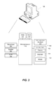
- FIG. 1 depicts a system for generating a time-compressed nonlinear video preview of a route
- FIG. 2 depicts a mobile device as one example of a route-previewing device
- FIG. 3 depicts a desktop computer as another example of a route-previewing device
- FIG. 4 depicts a server that may function as a preview-generating device and/or an imagery server
- FIG. 5 depicts the selection of a starting point of a route on a map displayed on a mobile device
- FIG. 6 depicts the selection of a destination point on the map of FIG. 5 ;
- FIG. 7 depicts a route plotted on a map between the starting and destination points of FIG. 6 ;
- FIG. 8 depicts segments of the route having three navigational decision points and wherein the segments of the route are categorized in terms of navigational difficulty as easy, medium and hard;
- FIG. 9 is a flowchart depicting a method of generating a time-compressed nonlinear video preview of the route
- FIG. 10 is another flowchart depicting a method of generating the video preview by splicing together slow-motion video and time-compressed video;
- FIG. 11 is a mobile device displaying the video preview
- FIG. 12 is a mobile device displaying arrows and labels superimposed on the video preview.
- FIG. 13 is a mobile device displaying panning of the video preview at a navigational decision point.
- the present technology provides a time-compressed nonlinear video preview of a route.
- This time-compressed nonlinear video preview provides detailed video content of navigational decision points while providing only minimum video content for the zones where there are no navigational decision points.
- the video preview may be viewed as a prelude to navigating the route permitting the user to familiarize himself with the route.
- the video preview emphasizes the key navigational decision points along the route.
- the video preview may be generated by a preview-generating server or other such computing device from street-level imagery accessed from a street-level imagery database in response to a request from a mobile device or other computing device running a route-preview application.
- the request includes a starting point and a destination point to define the route.
- an inventive aspect of the present technology is a computer-implemented method for providing navigation information.
- the method entails identifying a route, identifying navigational decision points along the route, and generating a time-compressed nonlinear video preview of the route wherein the video preview of the route comprises more video imagery of portions of the route containing navigational decision points than portions of the route without navigational decision points.
- Another inventive aspect of the present technology is a computer-readable medium comprising instructions in code which when loaded into a memory and executed by a processor of a computing device cause the computing device to identify a route, identify navigational decision points along the route and generate a time-compressed nonlinear video preview of the route wherein the video preview of the route comprises more video imagery of portions of the route containing navigational decision points than portions of the route without navigational decision points.
- a computing device that includes a user input device for receiving a starting point and a destination that defines a route, a data transceiver for transmitting the route to a preview-generating server that generates a video preview of the route and a processor operatively coupled to the memory for cooperating with the data transceiver to receive the video preview of the route, the processor being further configured to cooperate with a display to play the video preview of the route.
- Yet a further inventive aspect of the present technology is a system that includes a route-previewing device for receiving input defining a starting point and a destination point and for identifying a route based on the starting point and the destination point, a preview-generating device for receiving the route from the route-previewing device and for generating an image request for the route and a street-level imagery server for receiving the image request from the preview-generating device and for communicating imagery of the route to the preview-generating device in response to the image request.
- the preview-generating device generates a time-compressed nonlinear route preview from the imagery of the route and communicates the preview to the route-previewing device to enable the route-previewing device to display the preview.
- FIG. 1 is a schematic depiction of a computerized system for providing a video preview of a route to enhance a navigational experience of a user.
- the system 10 shown by way of example in FIG. 1 includes a route-previewing device 100 (e.g. a mobile device or other computing device) for receiving input defining a starting point and a destination point and for identifying a route based on the starting point and the destination point.
- the illustrated system 10 further includes a preview-generating device 200 (e.g. a server) for receiving the route from the route-previewing device and for generating an image request for the route.
- the illustrated system 10 further includes a street-level imagery server 300 for receiving the image request from the preview-generating device and for communicating imagery of the route to the preview-generating device in response to the image request.
- the preview-generating device 200 generates a time-compressed nonlinear route preview from the imagery of the route and communicates the preview to the route-previewing device 100 to enable the route-previewing device 100 to display the preview.
- the preview-generating device 200 and the imagery server 300 may be consolidated in a single server.
- the route-previewing device may generate its own preview by obtaining the imagery from the imagery server.
- a single computing device may store street-level imagery locally in its own memory and may generate its own preview based on this locally stored street-level imagery.
- the route-previewing device 100 may be a mobile device (or wireless communications device).
- the mobile device 100 may communicate via the Internet 310 with preview-generating server 200 and the imagery server 300 .
- the mobile device may transmit and receive data packets via wireless/mobile network infrastructure.
- the mobile device 100 may employ GSM/UMTS/LTE technologies to receive data packets comprising the preview video from the preview-generating server 200 .
- the data packets sent and received by the mobile device 100 are communicated through a wireless data network represented schematically in FIG. 1 by the GERAN/UTRAN network 330 and the LTE-SAE network 340 .
- a 4G device will communicate via the LTE (Long-Term Evolution-System Architecture Evolution) network whereas a 3G device will access the IP network via GERAN (GSM EDGE Radio Access Network) or UTRAN (Universal Terrestrial Radio Access Network for a UMTS radio access network).
- LTE data packets are handled by mobile management entity (MME) 360 whereas GSM/UMTS data packets are handled by serving GPRS support node (SGSN) 370 .
- MME mobile management entity
- SGSN serving GPRS support node
- a Policy Charging and Rules Function (PCRF) 395 provides Quality-of-Service (QoS) information to the packet data network gateway, dynamically manages data sessions, and also determines a charging policy for packets.
- QoS Quality-of-Service
- FIG. 2 is a depiction of a mobile device (or wireless communications device) as one example of a route-previewing device 100 that may be used to preview the time-compressed nonlinear video of the route.
- a mobile device is illustrated as an exemplary route-previewing device, it will be understood that the route-previewing device may be a desktop computer, laptop computer, notebook, tablet, or any other computing device.
- a mobile devices includes cell phones, smart phones, mobile phones, portable digital assistants, or any other such portable, mobile or handheld electronic communications devices. From the foregoing, it will be appreciated that the route-previewing device may be a wired device or a wireless device.
- a mobile device acting as the route-previewing device 100 has a processor 110 and a memory 120 , 130 .
- the memory of the mobile device 100 may include flash memory 120 and/or random access memory (RAM) 130 although other types or forms of memory may be used.
- the device may also include expandable memory in the form of a removable microSD memory card.
- the mobile device 100 may include a position-determining subsystem 190 (e.g. a GNSS receiver such as a GPS receiver) for determining a current location of the mobile device.
- a position-determining subsystem 190 e.g. a GNSS receiver such as a GPS receiver
- the mobile device 100 includes a user interface 140 for interacting with the mobile device and its applications.
- the user interface 140 may include one or more input/output devices, such as a display screen 150 (e.g. an LCD or LED screen or touch-sensitive display screen e.g. an Active-Matrix Organic Light-Emitting Diode touchscreen display or equivalent), and a keyboard or keypad 155 .
- a pure touch-screen device may provide a virtual keyboard onscreen and thus need not have a physical keyboard.
- the user interface may also optionally include any other input devices such as an optical jog pad, thumbwheel, trackball, track pad, etc.
- the mobile device 100 may include a wireless transceiver 170 for communicating with other devices.
- the transceiver 170 may be a radiofrequency (RF) transceiver for wirelessly communicating with one or more base stations over a cellular wireless network using cellular communication protocols and standards for both voice calls and packet data transfer such as GSM, CDMA, GPRS, EDGE, UMTS, LTE, etc.
- RF radiofrequency
- the computing device 100 is a wireless communications device
- the device may include a Subscriber Identity Module (SIM) card 112 for GSM-type devices or a Re-Usable Identification Module (RUIM) card for CDMA-type devices.
- SIM Subscriber Identity Module
- RUIM Re-Usable Identification Module
- the RF transceiver 170 may include separate voice and data channels.
- the mobile device 100 may optionally include one or more ports or sockets for wired connections, e.g. USB, HDMI, FireWire (IEEE 1394), etc. or for receiving non-volatile memory cards, e.g. SD (Secure Digital) card, miniSD card or microSD card.
- wired connections e.g. USB, HDMI, FireWire (IEEE 1394), etc.
- non-volatile memory cards e.g. SD (Secure Digital) card, miniSD card or microSD card.
- the mobile device 100 For voice calls, the mobile device 100 includes a microphone 180 , a speaker 182 and/or an earphone jack.
- the device may include a speech-recognition subsystem for transforming voice input in the form of sound waves into an electrical signal. The electrical signal is then processed by a speech-recognition module (digital signal processor) to determine voice commands from the voice input.
- a speech-recognition module digital signal processor
- the position-determining subsystem 190 may be a Global Positioning System (GPS) receiver (e.g. in the form of a chip or chipset) for receiving GPS radio signals transmitted from one or more orbiting GPS satellites.
- GPS Global Positioning System
- References herein to “GPS” are meant to include Assisted GPS and Aided GPS.
- GPS Global Positioning System
- GNSS global navigation satellite system
- any other satellite-based navigation-signal broadcast system would therefore include other systems used around the world including the Beidou (COMPASS) system being developed by China, the multi-national Galileo system being developed by the European Union, in collaboration with China, Israel, India, China, Saudi Arabia and South Korea, Russia's GLONASS system, India's proposed Regional Navigational Satellite System (IRNSS), and Japan's proposed QZSS regional system.
- Beidou COMPASS
- GLONASS GLONASS
- IRNSS Regional Navigational Satellite System
- QZSS QZSS regional system.
- a radiolocation subsystem that determines its current location using radiolocation techniques, as will be elaborated below.
- the location of the device can be determined using triangulation of signals from in-range base towers, such as used for Wireless E911.
- Wireless Enhanced 911 services enable a cell phone or other wireless device to be located geographically using radiolocation techniques such as (i) angle of arrival (AOA) which entails locating the caller at the point where signals from two towers intersect; (ii) time difference of arrival (TDOA), which uses multilateration like GPS, except that the networks determine the time difference and therefore the distance from each tower; and (iii) location signature, which uses “fingerprinting” to store and recall patterns (such as multipath) which mobile phone signals exhibit at different locations in each cell.
- a Wi-FiTM Positioning System may also be used as a positioning subsystem. Radiolocation techniques and/or WPS may also be used in conjunction with GPS in a hybrid positioning system.
- the mobile device 100 may include a Wi-FiTM transceiver 192 (e.g. IEEE 802.11a/b/g/n), a Bluetooth® transceiver 194 , and/or a near-field communications (NFC) chip 195 .
- the mobile device 100 may also optionally include a transceiver for WiMaxTM (IEEE 802.16), a transceiver for ZigBee® (IEEE 802.15.4-2003 or other wireless personal area networks), an infrared transceiver or an ultra-wideband transceiver.
- the mobile device may include other sensors like a digital compass 196 (magnetometer) and/or a tilt sensor or accelerometer 198 .
- the device may optionally include other sensors such as a proximity sensor, ambient light sensor, and gyroscope.
- the mobile device may include a digital camera 199 .
- FIG. 3 shows a schematic depiction of a desktop computer as another example of a route-previewing device 100 .
- the computing device e.g. desktop computer
- the computing device 100 includes a processor 110 and memory (including ROM 121 and RAM 130 ).
- the computing device 100 includes a data transceiver 170 (e.g. a modem such as a DSL modem or a coax cable modem) and a user interface 140 that includes a display 150 , a keyboard 155 and a mouse 156 .
- the computer may optionally include other components such as a microphone 180 , speaker 182 and Wi-Fi transceiver 192 .
- the computer may be connected to the Internet 310 via the data transceiver (modem) 170 to communicate with the preview-generating device 200 or, in other embodiments, with the street-level imagery server 300 .
- FIG. 4 shows a schematic depiction of certain components of a server which may be a preview-generating server 200 or an imagery server 300 (or a consolidated previewing-generating and imagery server).
- This server 200 , 300 includes a microprocessor 110 , memory (ROM 121 , RAM 130 ), a data transceiver (modem) 170 .
- the server may also include a user interface 140 that includes a display 150 , keyboard 155 and mouse 156 .
- the preview may be generated on the device or in cloud computing environment.
- the preview may be partially generated by the server 200 and partially generated by the device.
- the route-previewing device 100 receives user input via a keyboard, mouse, touch-screen, etc. specifying a route.
- This user input may be a starting point and a destination point.
- the starting point and destination point may be specified using coordinates of latitude and longitude, a street address, city name, postal code, or by selecting a point, POI or object on a map.
- FIG. 5 shows an example in which a user touches a first point on a map 400 displayed on a touch-sensitive screen of a mobile device. Touching the first point on the map on the touch-screen display causes a starting point 402 to be defined. In another embodiment, the starting point may be a current location of the device 100 as determined using the position-determining subsystem 190 .
- the user may touch a second point on the map to define a destination.
- the device 100 Based on the starting point and destination, the device 100 identifies the route. There may be multiple possible routes between the starting point and destination point 404 .
- the starting point 402 and destination point 404 define the route. This may be performed within a navigation application or a mapping application that provides route directions.
- the device 100 may select the shortest or fastest route, or the route with the least traffic, or it may request user input to select the route. Determining the route may be done locally or by sending the starting and destination points to a mapping server to obtain the route.
- FIG. 7 depicts a route 406 displayed on the map as determined by the mobile device 100 or by a server in communication with the mobile device. Instead of the dashed line as shown in FIG. 7 , the route 406 may be highlighted with a different colour or marked using any other suitable graphical technique such as superimposing a partially transparent line over the route.
- the server may be a map server, routing server or it may be the preview-generating server 200 .
- the route-previewing device 100 communicates the route (or alternatively the starting point and destination point) to the preview-generating device (server) 200 .
- the preview-generating server 200 identifies navigational decision points along the route. For example, the navigation decision points (NDP#1, NDP#2, NDP#3) are identified in FIG. 8 . Alternatively, this may be done by the route-previewing device 100 prior to sending the route to the server 200 .
- the navigational decision points may include intersections, forks in the road, on-ramps and off-ramps, turns, or any other critical point along the route where the navigation provides instructions to the user to turn, change lanes, enter an on-ramp or exit an off-ramp.
- the navigational decision points may be points where statistical traffic data indicates that there are frequent accidents or navigational errors.
- all navigational decision points are used (included) when generating the video.
- only a subset of all navigational decision points are included in the video.
- the server 200 may filter out navigational decision points based on user-specified parameters sent from the route-previewing device 100 .
- the parameters may specify that only turns onto different streets are to be treated as navigational decision points, and not for example on-ramps or off-ramps.
- the navigational decision points may be graded or ranked in terms of their navigational complexity (likelihood of making a navigational error).
- the highly complex points may be presented in very slow motion, the medium complexity points in slow motion, and the low complexity points at normal (real-world) or accelerated speed.
- the process of generating the video preview may commence.
- street-level imagery of the route must be obtained from the street-level imagery server 300 .
- the device 200 may request all available street-level images for the complete route although a more efficient approach would be for the device 200 to request only a subset of the available street-level images.
- the device 200 may, for example, request all available imagery for a navigational decision point but only a few sample or representative images along a segment of the route that contains no decision points. This latter technique reduces the amount of data that has to be transferred.
- generating the video comprises defining segments of the route, assigning a navigational complexity score to each segment of the route, and time-compressing the segments based on the score for each segment of the route.
- FIG. 8 shows how the route is divided up into segments that are categorized in terms of their navigational difficulty as easy, medium or hard. Any other categorization or ranking system may be employed to rate the segments in terms of their navigational complexity.
- each segment may be given a score of 1 to 5 with 1 being navigationally simple and 5 being navigationally complex.
- the degree of time-compression would be based on the scoring, e.g. a segment scored as 2 would thus be compressed more than a segment scored as 4.
- This scoring method is simply one way of ranking segments of a route to provide variable time-compression of each different segment of the route.
- the scoring method may include more or less scores and may be ranked in reverse order to the example given above.
- the preview-generating device 200 upon receipt of the images from the image server 300 generates a time-compressed nonlinear video preview of the route.
- the preview is time-compressed in the sense that the time to view the route preview video is shorter in time than the actual time required to drive the route. For example, if it takes 1 minute to drive a 1 km segment at a speed of 60 km/h, the real-world viewing time would be 1 minute but the preview may last only 30 seconds in which case the time compression would be 2:1. If the preview lasts only 10 seconds, the time compression would be 6:1.
- the time compression may be user-varied in response to user input.
- the route preview is nonlinear in the sense that navigationally challenging portions of the route are emphasized by showing them, for example, in slow-motion whereas navigationally simple portions of the route are skimmed over (i.e. presented quickly by a few representative images).
- the degree of nonlinearity may also be user-varied in response to user input.
- the device may extend or curtail the amount of video imagery presented at a navigational decision point in response to user input.
- the selected images for the route are spliced together to form a video.
- the video may be in any suitable format such as, but not limited to, AVI, MOV, WMV, MPEG-4.
- the method or process of generating the preview video may entail, as shown in FIG. 9 , a step 500 of identifying the route, a step 510 of identifying navigational decision points along the route, and a step 520 of generating a time-compressed nonlinear video preview of the route.
- the video preview of the route comprises more video imagery of portions of the route containing navigational decision points than portions of the route without navigational decision points. More video imagery means that there may be more video frames, a longer play time and/or higher resolution video frames.
- the method may, in one particular implementation depicted in the flowchart of FIG.
- the video may be downloaded to the device or streamed back to the device.
- the preview-generating device 200 may optionally add audible narration to the video to explain verbally what the user is seeing in the preview.
- the device 200 thus generates audible commentary to accompany the video (i.e. to be incorporated into the video as an audio sound track).
- the route-previewing device 100 may play the audible commentary with (or as part of) the video. For example, at a navigational decision point, the video may provide narration (spoken instructions) such as “You will then turn right on Main Street. Be careful to get into the rightmost turning lane.”
- the device may play the video preview in response to user input (e.g. a play video command) or the device may be programmed to automatically play the video preview as a prelude to navigating a route.
- FIG. 11 shows an example of a frame of a video preview 600 showing the route to be navigated.
- the device may also display a video control bar 610 may be displayed with functions such as pause, stop, fast-forward, rewind, etc.
- the video preview, or any part or segment thereof may be played during the navigation. For example, if a user is stationary at a traffic light, service station, rest stop, or parking spot, the user may request that the device provide a preview of the next section of the route.
- This request may be via manual input, touch input, or voice command such as “Show next preview” or “Show me the next section of the route”.
- the device would then display the portion of the video from the current location to the next decision point or beyond.
- the device only displays the preview if the device is stationary. The preview may thus be stopped if the car starts to move.
- the preview may be activated even if the navigation application is not providing navigation instructions or if the navigation application is not executing on the device. If the user was just driving normally and stopped at a traffic light or other location, the user could request a preview of the area beyond the intersection or around a corner.
- the device would play a short preview of what is around the corner or down the street. This could be implemented with a fast processor or by caching a preview for an upcoming decision point.
- the video imagery of the preview 600 may be superimposed with labels 620 (street names, addresses, POI names, landmark names, commercial entity names, etc.) and/or arrows 630 (showing how to navigate the decision point, e.g. where exactly to turn).
- labels 620 street names, addresses, POI names, landmark names, commercial entity names, etc.
- arrows 630 shown how to navigate the decision point, e.g. where exactly to turn.
- the slow-motion video imagery may include collateral imagery visible by panning side to side at navigational decision points.
- the video may slow down, pan left, then pan right (or vice versa), and then continue to advance slowly through the intersection.
- a navigational decision point such as an intersection
- the video may slow down, pan left, then pan right (or vice versa), and then continue to advance slowly through the intersection.
- FIG. 13 shows an example of a view of a forested area to the left of the route that becomes visible when panning to the left.
- displaying the slow-motion video at a navigational decision point may include providing both real-speed video imagery followed by a slow-motion replay of the same decision point.
- the video preview may present an intersection, turnoff or other decision point at a speed that represents the real-world speed at which a vehicle would travel through the decision point or it may present this decision point at an accelerated speed. The same intersection or decision point may then be replayed in slow motion.
- this technology enables a short preview video to be generated and presented to a user intending to navigate a route.
- the method generates a short preview video of the trip so that the user can preview the route before actually driving the route. This permits the user to note important landmarks, turns and intersections that the user will encounter along the route.
- the method may compress simple portions of the trip (e.g. uncomplicated highway sections) and elongate complex or noteworthy sections (e.g. intersections, turns, lane mergers or notable landmarks or points of interest).
- the user would enter a starting address and a destination address into the application on the device (or, alternatively, use the current location as the starting address).
- the device would transmit this data to the server which would then compile a video preview from street-level imagery.
- the device would playback the video preview (with optional audible instructions) showing how to get on the highway in, for example, 10 seconds.
- the preview then would for example devote another 10 seconds to show the simple highway section between the two cities, perhaps pausing or slowing along the way to emphasize or highlight sections where the user needs to be in a certain lane.
- the video preview would then, for example, slow down to show how to transfer onto the correct lane for getting on the expressway into Toronto.
- the video preview would then, for example, devote a full 10 seconds to show the approach to the off ramp, taking time to pan the camera left and right to show the surroundings.
- the remainder of the video would for example show the various intersections in downtown Toronto leading to the destination with the video slowing and panning at each required turn to familiarize the user with each turn while moving at time-compressed (“fast-forward”) speed though intersections where there is no turn to be made.
- this video may include audible instructions, arrows, textual labels, etc which may be overlaid on the video frames to provide further information to the user.
- the device could learn the user's familiarity with segments of the route.
- that segment of the route may be categorized by the device as easy or simple, permitting a greater compression of that segment than would ordinarily be done for a typical user.
- the degree of compression and/or nonlinearity may be automatically adjusted based on the user's location, language or other such factors. For example, the device may consider whether the route in within the user's home country or within a foreign country, whether the device language (user's language) is different from the local language (the local road signs). The device may also consider other such factors that may suggest some familiarity with the local roadway, local language and local traffic signage system.
- the video preview could obtain daytime or night-time imagery, seasonal imagery (winter imagery, summer imagery, etc.), or weather-specific imagery (sunny, rainy, cloudy, snowing, etc.) from the imagery server.
- Imagery that shows the street view as it would appear for a given time of day or night, a given season and for given weather conditions can enhance the navigational experience for the user by showing what would actually be visible along the route.
- the video preview could present two or more alternate routes to the destination or any detours that may be encountered along the route. Detours may be automatically suggested in response to the receipt of real-time traffic data, road construction reports, accident reports, weather alerts, etc).
- any of the methods disclosed herein may be implemented in hardware, software, firmware or any combination thereof.
- the method steps, acts or operations may be programmed or coded as computer-readable instructions and recorded electronically, magnetically or optically on a fixed or non-transitory computer-readable medium, computer-readable memory, machine-readable memory or computer program product.
- the computer-readable memory or computer-readable medium comprises instructions in code which when loaded into a memory and executed on a processor of a computing device cause the computing device to perform one or more of the foregoing method(s).
- a computer-readable medium can be any means that contain, store, communicate, propagate or transport the program for use by or in connection with the instruction execution system, apparatus or device.
- the computer-readable medium may be electronic, magnetic, optical, electromagnetic, infrared or any semiconductor system or device.
- computer executable code to perform the methods disclosed herein may be tangibly recorded on a computer-readable medium including, but not limited to, a floppy-disk, a CD-ROM, a DVD, RAM, ROM, EPROM, Flash Memory or any suitable memory card, etc.
- the method may also be implemented in hardware.
- a hardware implementation might employ discrete logic circuits having logic gates for implementing logic functions on data signals, an application-specific integrated circuit (ASIC) having appropriate combinational logic gates, a programmable gate array (PGA), a field programmable gate array (FPGA), etc.
Abstract
Description
Claims (19)
Priority Applications (4)
| Application Number | Priority Date | Filing Date | Title |
|---|---|---|---|
| US14/014,599 US9482547B2 (en) | 2013-08-30 | 2013-08-30 | Method and device for computer-based navigation |
| CA2859552A CA2859552C (en) | 2013-08-30 | 2014-08-18 | Method and device for computer-based navigation |
| EP14181429.3A EP2843368B1 (en) | 2013-08-30 | 2014-08-19 | Method and system for computer-based navigation |
| HK15108371.5A HK1207681A1 (en) | 2013-08-30 | 2015-08-28 | Method and device for computer-based navigation |
Applications Claiming Priority (1)
| Application Number | Priority Date | Filing Date | Title |
|---|---|---|---|
| US14/014,599 US9482547B2 (en) | 2013-08-30 | 2013-08-30 | Method and device for computer-based navigation |
Publications (2)
| Publication Number | Publication Date |
|---|---|
| US20150066368A1 US20150066368A1 (en) | 2015-03-05 |
| US9482547B2 true US9482547B2 (en) | 2016-11-01 |
Family
ID=51359291
Family Applications (1)
| Application Number | Title | Priority Date | Filing Date |
|---|---|---|---|
| US14/014,599 Active US9482547B2 (en) | 2013-08-30 | 2013-08-30 | Method and device for computer-based navigation |
Country Status (4)
| Country | Link |
|---|---|
| US (1) | US9482547B2 (en) |
| EP (1) | EP2843368B1 (en) |
| CA (1) | CA2859552C (en) |
| HK (1) | HK1207681A1 (en) |
Cited By (1)
| Publication number | Priority date | Publication date | Assignee | Title |
|---|---|---|---|---|
| CN114548333A (en) * | 2022-02-15 | 2022-05-27 | 湖南金丰林印刷包装机械科技有限公司 | Method and device for processing 5G and radio frequency tag combined goods path |
Families Citing this family (12)
| Publication number | Priority date | Publication date | Assignee | Title |
|---|---|---|---|---|
| US9482547B2 (en) * | 2013-08-30 | 2016-11-01 | Blackberry Limited | Method and device for computer-based navigation |
| US9599485B2 (en) | 2014-05-30 | 2017-03-21 | Apple Inc. | Navigation peek ahead and behind |
| US9489670B2 (en) * | 2015-01-15 | 2016-11-08 | Conversant Ip Management Inc. | Hybrid wireless short range payment system and method |
| US9903735B2 (en) | 2015-03-30 | 2018-02-27 | International Business Machines Corporation | Route stabilization scrolling mode |
| US11164272B2 (en) * | 2017-02-12 | 2021-11-02 | Tanner Michael Anderson | Mail carrier training method |
| DK201970121A1 (en) * | 2018-10-30 | 2020-06-04 | Aptiv Technologies Limited | Generation of optimal trajectories for navigation of vehicles |
| US11727800B2 (en) * | 2018-12-04 | 2023-08-15 | Mark43, Inc. | System and method for law enforcement incident reporting |
| JP7275556B2 (en) * | 2018-12-14 | 2023-05-18 | トヨタ自動車株式会社 | Information processing system, program, and information processing method |
| US10983690B2 (en) * | 2019-04-02 | 2021-04-20 | Motorola Mobility Llc | Methods and devices for precluding touch initiated control operations during three-dimensional motion |
| US11071916B2 (en) | 2019-04-24 | 2021-07-27 | Take-Two Interactive Software, Inc. | System and method for virtual navigation in a gaming environment |
| DE102019206250A1 (en) * | 2019-05-01 | 2020-11-05 | Siemens Schweiz Ag | Regulation and control of the running speed of a video |
| WO2022039718A1 (en) * | 2020-08-18 | 2022-02-24 | Google Llc | Navigation directions preview |
Citations (11)
| Publication number | Priority date | Publication date | Assignee | Title |
|---|---|---|---|---|
| JP2002257576A (en) | 2001-03-02 | 2002-09-11 | Mitsubishi Electric Corp | Route guide device and route guide method |
| US20070150188A1 (en) * | 2005-05-27 | 2007-06-28 | Outland Research, Llc | First-person video-based travel planning system |
| US20080312821A1 (en) | 2007-06-14 | 2008-12-18 | Mathias Muhlfelder | Method For Operating A Navigation System |
| US20090289937A1 (en) * | 2008-05-22 | 2009-11-26 | Microsoft Corporation | Multi-scale navigational visualtization |
| US20100094533A1 (en) | 2007-05-25 | 2010-04-15 | Chun-Hsien Wu | Method and apparatus for variable speed route simulation operation for navigation system |
| US20100161207A1 (en) * | 2008-12-24 | 2010-06-24 | In-Young Do | Mobile terminal and method for providing location-based service thereof |
| US20100169010A1 (en) * | 2008-12-29 | 2010-07-01 | Lg Electronics Inc. | Multi-device mapping functionality |
| EP2280244A1 (en) | 2009-07-27 | 2011-02-02 | HTC Corporation | Method for simulating navigation route, navigation apparatus and computer program product |
| US20110112750A1 (en) * | 2008-10-07 | 2011-05-12 | Robert Lukassen | Route preview |
| US20140129976A1 (en) * | 2012-11-05 | 2014-05-08 | Nokia Corporation | Method and apparatus for conveying efficient map panning over a mapping user interface |
| US20150066368A1 (en) * | 2013-08-30 | 2015-03-05 | Blackberry Limited | Method and device for computer-based navigation |
-
2013
- 2013-08-30 US US14/014,599 patent/US9482547B2/en active Active
-
2014
- 2014-08-18 CA CA2859552A patent/CA2859552C/en active Active
- 2014-08-19 EP EP14181429.3A patent/EP2843368B1/en active Active
-
2015
- 2015-08-28 HK HK15108371.5A patent/HK1207681A1/en unknown
Patent Citations (11)
| Publication number | Priority date | Publication date | Assignee | Title |
|---|---|---|---|---|
| JP2002257576A (en) | 2001-03-02 | 2002-09-11 | Mitsubishi Electric Corp | Route guide device and route guide method |
| US20070150188A1 (en) * | 2005-05-27 | 2007-06-28 | Outland Research, Llc | First-person video-based travel planning system |
| US20100094533A1 (en) | 2007-05-25 | 2010-04-15 | Chun-Hsien Wu | Method and apparatus for variable speed route simulation operation for navigation system |
| US20080312821A1 (en) | 2007-06-14 | 2008-12-18 | Mathias Muhlfelder | Method For Operating A Navigation System |
| US20090289937A1 (en) * | 2008-05-22 | 2009-11-26 | Microsoft Corporation | Multi-scale navigational visualtization |
| US20110112750A1 (en) * | 2008-10-07 | 2011-05-12 | Robert Lukassen | Route preview |
| US20100161207A1 (en) * | 2008-12-24 | 2010-06-24 | In-Young Do | Mobile terminal and method for providing location-based service thereof |
| US20100169010A1 (en) * | 2008-12-29 | 2010-07-01 | Lg Electronics Inc. | Multi-device mapping functionality |
| EP2280244A1 (en) | 2009-07-27 | 2011-02-02 | HTC Corporation | Method for simulating navigation route, navigation apparatus and computer program product |
| US20140129976A1 (en) * | 2012-11-05 | 2014-05-08 | Nokia Corporation | Method and apparatus for conveying efficient map panning over a mapping user interface |
| US20150066368A1 (en) * | 2013-08-30 | 2015-03-05 | Blackberry Limited | Method and device for computer-based navigation |
Non-Patent Citations (1)
| Title |
|---|
| European Patent Office, Extended European Search Report, Patent No. 2843368, Apr. 1 2015. |
Cited By (2)
| Publication number | Priority date | Publication date | Assignee | Title |
|---|---|---|---|---|
| CN114548333A (en) * | 2022-02-15 | 2022-05-27 | 湖南金丰林印刷包装机械科技有限公司 | Method and device for processing 5G and radio frequency tag combined goods path |
| CN114548333B (en) * | 2022-02-15 | 2023-11-14 | 湖南金丰林印刷包装机械科技有限公司 | 5G and radio frequency tag combined cargo path processing method and device |
Also Published As
| Publication number | Publication date |
|---|---|
| US20150066368A1 (en) | 2015-03-05 |
| EP2843368A3 (en) | 2015-04-29 |
| EP2843368A2 (en) | 2015-03-04 |
| CA2859552C (en) | 2023-08-01 |
| CA2859552A1 (en) | 2015-02-28 |
| HK1207681A1 (en) | 2016-02-05 |
| EP2843368B1 (en) | 2018-10-03 |
Similar Documents
| Publication | Publication Date | Title |
|---|---|---|
| CA2859552C (en) | Method and device for computer-based navigation | |
| US10760921B2 (en) | Start-of-route map navigation with suppression of off-route feedback | |
| US9891058B2 (en) | Method and apparatus for providing navigation guidance via proximate devices | |
| US9823077B2 (en) | Navigation application with several navigation modes | |
| US10126142B2 (en) | Methods and systems for obtaining navigation instructions | |
| US8874366B2 (en) | First waypoint distance | |
| US10876848B2 (en) | Methods and systems for generating routes | |
| US9476727B2 (en) | Method and apparatus for predicting destinations | |
| US20090177378A1 (en) | Navigation device and method | |
| US11677930B2 (en) | Method, apparatus, and system for aligning a vehicle-mounted device | |
| US11761772B2 (en) | Method and apparatus for providing speculative navigation routing in incomplete offline maps | |
| US20170146352A1 (en) | Wireless navigation apparatus, method, and system | |
| EP3663972A1 (en) | Method and apparatus for providing real time feature triangulation | |
| US20100268461A1 (en) | Navigation apparatus, data processing apparatus, and geographic map data application method | |
| JP2010210339A (en) | On-vehicle navigation device, and method and program of controlling the on-vehicle navigation device | |
| JP2012037475A (en) | Server device, navigation system and navigation device | |
| US20160076902A1 (en) | Colloquial or user-favored route based navigation instructions | |
| JP5032592B2 (en) | Route search device, route search method, route search program, and recording medium | |
| CN101995260A (en) | Navigation device, data processing device and geographic image information application method | |
| JP2009237432A (en) | Route guidance device for vehicle, and guidance route display method | |
| JP2017102172A (en) | Map image display system, map image display method, and computer program |
Legal Events
| Date | Code | Title | Description |
|---|---|---|---|
| AS | Assignment |
Owner name: BLACKBERRY LIMITED, CANADA Free format text: ASSIGNMENT OF ASSIGNORS INTEREST;ASSIGNORS:WALKER, DAVID RYAN;MCKENZIE, DONALD SOMERSET MCCULLOCH;REEL/FRAME:031116/0690 Effective date: 20130827 |
|
| AS | Assignment |
Owner name: BLACKBERRY LIMITED, ONTARIO Free format text: CHANGE OF NAME;ASSIGNOR:RESEARCH IN MOTION LIMITED;REEL/FRAME:034161/0093 Effective date: 20130709 |
|
| STCF | Information on status: patent grant |
Free format text: PATENTED CASE |
|
| MAFP | Maintenance fee payment |
Free format text: PAYMENT OF MAINTENANCE FEE, 4TH YEAR, LARGE ENTITY (ORIGINAL EVENT CODE: M1551); ENTITY STATUS OF PATENT OWNER: LARGE ENTITY Year of fee payment: 4 |
|
| AS | Assignment |
Owner name: MALIKIE INNOVATIONS LIMITED, IRELAND Free format text: ASSIGNMENT OF ASSIGNORS INTEREST;ASSIGNOR:BLACKBERRY LIMITED;REEL/FRAME:064104/0103 Effective date: 20230511 |
|
| AS | Assignment |
Owner name: MALIKIE INNOVATIONS LIMITED, IRELAND Free format text: NUNC PRO TUNC ASSIGNMENT;ASSIGNOR:BLACKBERRY LIMITED;REEL/FRAME:064271/0199 Effective date: 20230511 |