Calanque de Sugiton was our favorite destination of our trip. The trail is easier than Port Pin, most of it on a dirt or semi-paved road, which means it attracts more people than other less accessible inlets. The Calanque itself is more interesting that the others we saw because it has lots of rock formations for scrambling and exploring. If I could pick only one calanque to visit, this would be it.
You can take an all-terrain stroller almost all the way to the water and I saw other families doing this. But once at the beach, it could be dangerous for small children that wander, with lots of small and big rocks and cliffs to fall off. So with small children, I prefer Port Pin which has a shorter, easier trail and a bigger, safer beach. Get details for the Port Pin hike.
Note: In summer, this area is often closed to hikers for fire risk. Check the trail status here. Sometimes they close the trail after a certain number of guests enter the park, so best to go early in the day or visit in early spring or late fall.
| Location: | Calanques National Park, southern France |
| Trail start: | Avenue de Luminy, Le Redon, Marseille |
| Parking: | Street parking: 43°13’50.6″N 5°26’12.7″E Overflow lot: 43°14’00.9″N 5°25’58.2″E |
| Trail: | 6 km to Sugiton and back |
| Elevation: | highest point 160m, total climb 80, total descent 157m |
| Condition: | rocky, dirt path – no strollers |
| Skill: | moderate |
| Open: | closed in summer (check status), best early spring and late fall |
| Cost 2018: | free to enter park, parking for a fee |
| More info: | www.marseille-tourisme.com |
Location
Calanque de Sugition is located in the middle of the Calanques National Park near Marseille in southern France. The trail starts in a town called Le Redon, where you can park or take a bus.

Trail Overview
From the center of Le Redon (also called Domaine de Luminy), this trail heads south on a wide dirt road to Col de Sugition, the highest point of the trail where you can get a panorama view over the Calanques park. Then the trail descends about 150m of elevation on a semi-paved road almost all the way to the ocean. The last bit is on a narrow dirt path, leading to a small beach. This trail is about 3 km each way.
You could take an all-terrain stroller almost all the way to the beach and park it on the road before you hike down the last bit to the water. I saw a few families doing this. There are lots of other paths trails leading in all directions if you want to loop back a different way.
There are lots of paths criss-crossing this area. We saw this posted map reminding hikers to stay on the main marked paths as shown here.

Also the trail markers are totally crazy and we couldn’t make any sense of them. Good luck.

How to get there & parking
I had trouble finding info about the trail and parking, so I made this map to help you. From Cassis or Marseille, take the D559 local highway towards Marseille, turning right on Avenue de Luminy.

Keep following this road straight into the town until you reach the metered street parking shown in the middle of the map below. The trail starts on the road leading south from the metered parking.

If the street parking is full, drive back on that road to the roundabout, and turn west toward the sports center and follow the road to the overflow parking shown on the map below. If you park in the overflow lot, you will see dirt trails leading southwest of the parking. Some of these trails will eventually lead you to Sugiton, but make sure you follow the signs. You can follow a more direct route, by first taking the path east through the building complexes over to the street parking, then following the dirt road south to Sugiton.
This pic shows the street parking on the left and overflow lot on the right.

Trail Impressions
We started hiking from the overflow lot, which wandered through the countryside before joining the main trail/road to Sugition. It was so pretty, I’m glad we didn’t miss this part.

Looking down toward Sugiton.

Joining the road at Col de Sugition leading down to the beach.

Easy walking on this road.

Almost there, glad to see the water.


Exploring the beach
The paved road ends high above the beach. From there you can take one of the rocky dirt paths down to water. We started with the path at the very end of the road. It was a little tricky getting down and could be difficult with small children. Be careful!

Lots of people lounge on the cliffs, plenty of room to spread out.

Lots of fun places to climb around but be careful!

It would be good to have water shoes with some grip so you can explore better.


So so pretty!!!

Looking back at the little beach from the cliffs where we were climbing around.

There are two little beaches for swimming. This one is a bit better for children because it’s very shallow and a bit sheltered from the wind.

Here is the second beach a bit closer to the main path. Not so much room here.

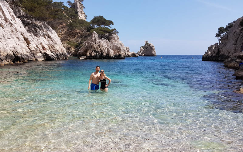
Gotta swim even if it’s so so cold!
On the way back, we took the second beach access path back up, which involved some stairs and lots of rocks.

On the way back, we took the dirt road directly back to the parking. It wasn’t as pretty as the way there and it was busier. But it was definitely easier and we were tired.

Want to see more? Check out our other Calanques posts.


2 Responses
Thank you so much for this article. It really helped me figure out how to get to Calanques de Sugiton. Last September we were on a Mediterranean cruise that stopped in Marseille for the day. Thanks to your helpful article we figured out how to get to Luminy and hike from there down to Calanques de Sugiton. It was spectacular!! It was a very unexpected highlight of our entire vacation. If you are interested you can see a video recap of our hike here – https://youtu.be/PEF6lthbi2U. Your directions were perfect! Thanks!
So glad I could help! Looking forward to watching your video.